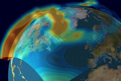
The ionosphere is the final layer of atmosphere before space. This highly dynamic region is constantly exposed to the full intensity of the Sun, harsh ultraviolet radiation breaking down molecules and atoms. Highly charged ions and free electrons therefore fill the ionospheric layers. Critical to terrestrial communications, the ionosphere also plays host to the largest lightshow on Earth, the Aurora. Now NASA-funded research has developed a live “4D Ionosphere” plugin for Google Earth. Now you can fly through the atmosphere’s uppermost reaches without even leaving your desk…
The ionosphere is highly important to us. Radio operators will be acutely aware about how the ionosphere influences radio wave propagation. Ever since Guglielmo Marconi’s experiments with trans-Atlantic radio communications in 1901 between England and the US, the ionosphere has influenced our ability to communicate over large distances, and without the aid of modern satellite technology. The ionosphere creates a charged, reflective barrier that radio waves can be bounced off (bypassing the blocking effect of the curvature of the Earth). However, radio signals are highly influenced by variations in the ionosphere and can be “blacked out” should a major solar storm pump charged particles into the magnetosphere and ionosphere. Even modern Global Positioning Satellite (GPS) signals are influenced by this atmospheric layer, reflecting and attenuating radio waves. As aircraft, ships and other modes of transport now depend on GPS positioning, it is essential that we fully comprehend the physics behind the ionosphere.
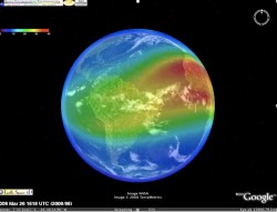
In the aim to have a better grasp of the state of the ionosphere, a “live” plugin for Google Earth has just been announced. Funded by NASA’s Living With a Star (LWS) program, it is hoped that this tool can be used by the public and professionals alike to see the current state of the electron content of the ionosphere. Once downloaded and running, the viewer can rotate the globe and see where electron density is high and where it is low. In dense regions, it is very hard for radio waves to propagate, signifying that radio quality will be poor, or blocked all together. In Google Earth, these regions are highlighted in red. The blue regions show “normal” radio propagation regions, expect good quality signal in those locations.
The reason why this new system has been dubbed “4D Ionosphere” is that you can view the ionosphere in three spatial dimensions, and the data is refreshed every ten minutes to give the extra time dimension.
- Download the .kml “4D Ionosphere” Google Earth plugin »
- View video tutorial of how to use “4D Ionosphere” (19MB .mp4 video) »
- Download Google Earth »
This isn’t the first time Google Earth has been used by organizations for space-based research. On February 24th, I reported that a plugin had been released to track the space debris currently orbiting our planet. Nancy also gave the new Google Sky a test drive in March, a great way to learn about astronomy through this user friendly interface.
I can see lots of applications for this tool already. Firstly I’d be very excited to compare the ionosphere during periods of high solar activity with periods when the Sun experiences solar minimum (like now). This would be especially exciting in Polar Regions in the auroral zone when high quantities of solar wind particles ignite aurorae. Also, there are possible applications for amateur radio (ham) operators who could use this as a means to forecast the strength of the radio signal during campaigns. I am however uncertain how accurate or how detailed these measurements will be, but it at least gives a very interesting look into the current state of this interesting region of the atmosphere.
Source: NASA


Hey! What happened to the nova in Sagittarius? I’ve been looking everywhere but cant fine any new info
Well, that’s interesting. Too bad I’m still one of the peasants still on a dial-up & so, the magnificence of this development will be forever lost to me (well, until I decide to get broadband….)
I’ve come across data sets of ionospheric electron density before and there are a lot of black patches. It’s not down to covering up secrets, it’s more a lack of data. I’m actually surprised that we have global coverage of ionospheric electron content at all. Will keep you posted if I find out any more 🙂
More censored black patches! More unrevealable secrets!
Hey that’s an idea Tammy… I’m not totally familiar with the effects of meteors on the ionosphere. Would this be a large-scale global effect? It might well be picked up by Google Earth! That would be fun. Fancy a virtual ionosphere observing campaign??? I think you’re on to something here! 🙂
Cheers, Ian
Very impressive article, Ian… And you’re right – there’s some very interesting applications out there just waiting to be explored.
Perhaps it would be fun if we both monitored some time during a meteor shower? Ham radio operators use the ionic meteor scatter to bounce signals further, so I’m thinkin’ this might actually show! Your comments on aurora are also very viable…
One thing is for sure, I’ve just sat here like Pavlov’s dog for the last couple of hours! 😉
…vag? sorry, i was totally away from the internet to attend NEAF. during that time, Nova Sgr went downhill and we’re back to just an ordinary little star in the midst of many. like most events, it’s there – and then gone.
When I tried to run the 4D Ionosphere tutorial, I got this error:
Couldn’t open the file “Ionosphere_WebShort_320x240.mp4” because an unknown error occurred. The number of the error is: -8971.
Help!
howdy, don!
i erased and redid everything this morning and it seems to be working fine from this end. why not try again? it may have been a fluke of the moment…
How do you get the time axis going (for the predictions)? It shows this feature in the video tutorial but I don’t see anywhere to active it. When I first load the .kml file, there appears for about 1/3 of a second a slider in the upper right that looks like the right slider to access the time dimension, but then it immediately disappears! Help!
Tammy, I tried it again to open the file “Ionosphere_WebShort_320×240.mp4” and got the same error (“Unknown error number -8971”) . I have the latest updates for Quicktime, running under XP/SP3.
I give up!
Google ionoshere?What purpose does this serve?I been looking at the colors on the globe and it means what?
Current and predicted communications conditions
* Red – high frequencies (HF) are unavailable (>22 MHz)
* Yellow – lowest usable frequency (LUF) and maximum usable frequency (MUF) range is 15-22 MHz
* Green – LUF-MUF range is 8-15 MHz
* Blue – LUF-MUF range is 3-8 MHz
Now,Green means that the range 8-15 is good or bad?Red is Bad for 22mhz and up?Then what is red good for in mhz?So vague.Make it simple.Red is for WHAT?And what the heck is:
Communication Alert: HF 08-15 MHz
If I tune there my radio explodes?Dumbest over thought program ever.