Caption: NASA Earth Observatory image by Jesse Allen
At 21:53 UTC on January 12, 2010 an earthquake with a magnitude 7.0 struck the Caribbean nation of Haiti. The US Geological Survey (USGS) says that it was the most violent earthquake to strike the impoverished country in a century, and death tolls are reported to be rising into the hundreds of thousands. “Porte-au-Prince is probably one of the worst constructed cities in the world, and even the presidential palace collapsed,” said Roger Bilham, from the University of Colorado-Boulder. “This is an earthquake many of us were expecting to occur sooner or later.”

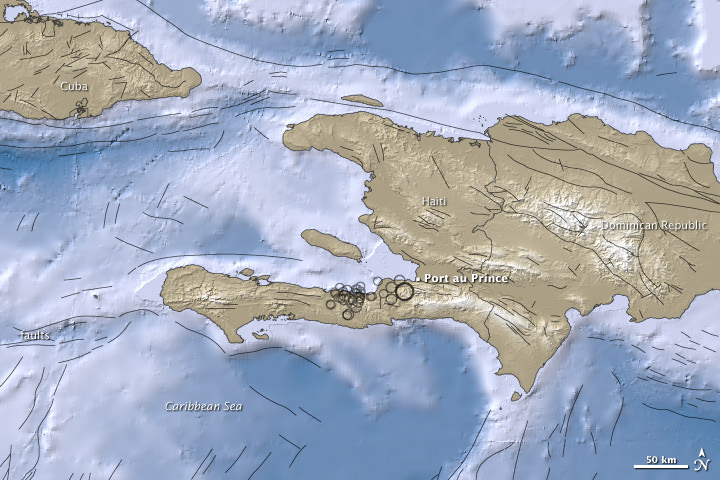
This image from the USGS shows all the seismic activity in the region, including areas in the ocean.
Dennis Mileti, also from CU-Boulder said three factors contributed to the severity of the Haitian event: the shallow location of the earth quake (only 8.3 kilometers or 5.2 miles underground) resulting in high shaking intensity; the low-quality construction of structures in the area; and the lack of earthquake preparedness and increased vulnerability resulting from Haiti being a poor country.
The epicenter of the earthquake was just 15 kilometers (10 miles) southwest of the Haitian capital of Port-au-Prince. Besides its strong magnitude, the earthquake’s shallow depth ensured that the densely populated capital would suffer violent shaking. More than 30 aftershocks rocked the area.
Reports say a majority if the infrastructure has collapsed, including schools, hospitals, government buildings – such as the presidential palace and the main prison — aid centers, and shantytowns.
The top map shows the region surrounding the 7.0-magnitude earthquake and the aftershock. Earthquake magnitudes are measures of earthquake size calculated from ground motion recorded on seismographs.
Ocean areas appear in shades of blue, and land areas appear in shades of brown. Both in water and on land, higher elevation appears in lighter colors. Black circles mark earthquake locations determined by the USGS, and circle sizes correspond with quake magnitudes. Black lines indicate fault lines.
The map was created using earthquake and plate tectonics data from the USGS Earthquake Hazard Program, elevation data from the Shuttle Radar Topography Mission (SRTM) courtesy of the University of Maryland’s Global Land Cover Facility, and ocean bathymetry data from the British Oceanogprahic Data Centre’s (BODC) General Bathymetric Chart of the Oceans (GEBCO).
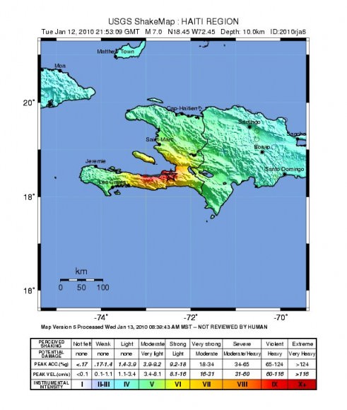
This “shake” map from the USGS shows the intensity of shaking felt across the region in Haiti.
The USGS said the earthquakes occurred along the boundary between the Caribbean and North America plates. This area is characterized as a strike-slip fault where the Caribbean plate moves eastward with respect to the North America plate.
But Haiti wasn’t the only place an earthquake has taken place recently. Check out this intriguing map of earthquakes in the past week.
Sources: NASA Earth Observatory, USGS, University of Colorado-Boulder, Nature,


Last Saturday there was a 6.5 mag. earthquake on the California coast, near Eureka. I heard about that one and decided to take a look at the NGS earthquake page. I noted at the time that the entire Pacific rim had an unusually large number of recent quakes… especially in Calif., Alaska and NW of Australia. Then this one struck Haiti.
The full moon on the 1st was a ‘blue’ moon… so I looked at its location when it reached its fullest.. and the anti pole node. Tides near the winter solstice are the highest of the year.
Oops.. USGS @ http://earthquake.usgs.gov/
What I’d really like to see.. is a map of Earth’s mag.field for the last coupla weeks… and compare that with Sol’s.
Umm… thanks for the updated info. Those last two maps mean a lot to moi… dint see them when I first viewed this story? Added later?
You ROCK! Nancy… thanks.
Now if my two cats start doing ‘loop the loops’… I’m outta here! HO! Of course it prowlay dint help that I gave em some catnip a while ago…
Aqua- one was added, the other was a victim of our recent bout of mysterious image disappearance. You have to hold your tongue just right for images to appear….or something like that! We haven’t quite figured out the problem yet.
Damn – what a terrible thing to happen. Hopefully the world can get it’s act together and get them some aid and assistance stat…
What a sad tragedy in Haiti. I hear relief workers and supplies are on the way. It’ll be a long hard road to recover from that one.
Aqua, you might be interested in this paper. (in case you don’t see it on that other thread)
Investigation of ULF magnetic pulsations, air conductivity changes, and infra red signatures associated with the 30 October Alum Rock M5.4 earthquake
http://www.nat-hazards-earth-syst-sci.net/9/585/2009/nhess-9-585-2009.html
The full paper in a 6mb pdf is available at the bottom of the page.
My heart goes out to the Haitian people. I know that Obama has authorized relief funds to be sent. Let’s hope the rest of the world with the resources to do so follows suit. (China)
Haiti has had its share of troubles through history, and is the poorest nation in the American hemisphere. The US has intervened in the country a number of times, the latest being the coup against Aristide. And now this, a little over a year after a hurricane.
LC
Aqua,
You can get Earthquake history data from the USGS for events all over the world. You can even sign up for email and RSS feeds to alert you when one happens if you like.
Earthquakes for the past 7 days: http://earthquakes.usgs.gov/earthquakes/recenteqsww/Quakes/quakes_big.php
Earthquakes for the past 8-30 days: http://neic.usgs.gov/neis/qed/
Addendum to my earlier comments. This from today’s (01.14.10) SpaceWeather.com. “The Moon is about to pass directly in front of the sun, producing an annular solar eclipse on Jan. 15th between 0500 and 0900 UT. Onlookers in Africa, the Middle East, India and Asia should be alert for crescent-shaped shadows and “ring of fire” suns.”
That makes one lunar eclipse and one solar eclipse in this lunar cycle – not in itself unusual. But watch for ground motion at the anti pole? http://earthquake.usgs.gov/ That would be the Pacific rim or the west coast(s) of America. (I hope I’m wrong!)
Good to see the USA stepping up efforts in Haiti! The administration has promised $150 million in aid.
Unfortunately, this is something which will be felt by the entire area for a long time. Seeing and knowing 2-3 million people are left out in the open each night. Children who’ve lost parents and are literally alone and likely in shock; with nobody really around to take care of them. Tragedy is an understatement.
It makes you thankful for what you have.
No doubt there will be thousands if not tens-of-thousands of refugees storming the Dominican Republic. Not to mention the loss of more lives for those who brave whatever floats, trying to get to the US.
The ’88 quake in Armenia resulted in lots of deaths thanks to corrupt Soviet era construction. There is still recovery going on from it. The concern there and anywhere else that’s quake prone is will new buildings and structures be built up to code? It’s human nature to go back to old ways and not heed warnings. The ’88 quake killed about 25,000 people. People are throwing out figures like 40,000 and higher for Haiti.