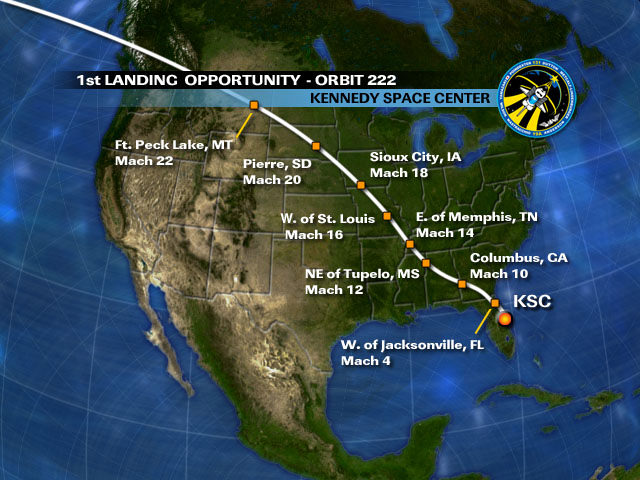
[/caption]
If the weather cooperates, space shuttle Discovery will attempt to land in Florida Monday morning using a so-called “descending node” where the trajectory will take it across the heart of the continental US. “The neat thing about the descending opportunities is it’s going to come across the country and folks will get a good opportunity, hopefully, to see the orbiter as it goes overhead,” said NASA entry flight director Bryan Lunney. This flight trajectoray hasn’t been used since before the Columbia disaster in 2003, to avoid flying over densely populated areas of the US. This descending node trajectory is favorable for adding extra crew time to the mission. The plan is for Discovery’s braking rockets to fire for three minutes and 11 seconds starting at 7:43:20 a.m. EDT Monday. This will slow the shuttle by about 217 mph for a landing at the Shuttle Landing Facility at Kennedy Space Center at 8:48:36 a.m. The second opportunity would be at 10:23:30 a.m.
But rain is in the forecast for Florida in Monday morning, so time will tell if the view will be available. As the shuttle crosses the Canadian border it would be only 43 miles high, providing a good view for viewers below.
According to Bill Harwood at CBS news, here is the flight path and expected speeds over each location, as marked on the map, above.
1. South of the Queen Charlotte Islands (western Canada)
2. Over British Columbia, northeast of Vancouver
3. Over southern Alberta province
4. Over Montana, flying over Fort Peck Lake (Mach 22)
5. Across the western border of North Dakota, then over northern South Dakota tracking northwest to southeast, directly over the capital of Pierre
6. Across Iowa directly over Sioux City and southwest of Des Moines and Council Bluffs, Iowa (Mach 18)
7. Over the heart of Missouri, between Kansas City and St. Louis (Mach 16)
8. Over the eastern border of Arkansas and Tennessee, east of Memphis (Mach 14)
9. Over NE Mississippi, northeast of Tupelo (Mach 12)
10. Over Alabama tracking northwest to southeast from Birmingham to Columbus, Georgia (Mach 10)
11. Over southwest Georgia south of Americus
12. Over Florida, almost directly over Jacksonville (Mach 4)
13. West of St. Augustine and Daytona Beach, onto KSC
Source: CBS, NASA


Nice map, too bad they couldn’t include useful information like the time the shuttle will be overhead instead of the speed.
here is where to get the exact shuttle location in real time:
http://spaceflight.nasa.gov then click “Realtime Data” on the bar.
Then click “Sighting Opportunities”
Then click the “start applet’ in the picture” , wait and click on the black dot of your continent and go from there.
fool around with all the info and have fun!
HERE is where to get the exact shuttle location in real time:
http://spaceflight.nasa.gov then click “Realtime Data” on the bar.
Then click “Sighting Opportunities”
Then click the “start applet’ in the picture” , U will get a B&W map of the world;
FIRST click on the black dot of your continent and go from there to select your city (or nearest metro area)
THEN click on the “Sat info” tab above the map and open the “Select Satellite:” drop-down and(for today and maybe tomorrow), choose KSC 222 etc for the Discovery re-entry paths
fool around with all the info and have fun!