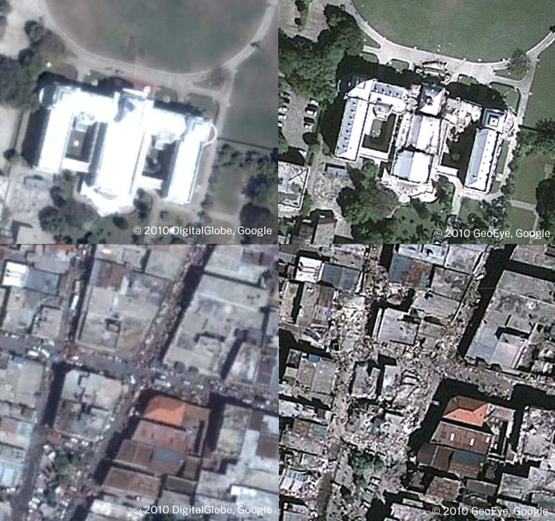
[/caption]
The folks at Google Earth and the satellite imaging company GeoEye have teamed up to make available the most recent Haiti photos — taken at approximately 10:27am EST on January 13, 2010. It is available as a KML overlay for Google Earth, and you can download the KML here and open it in Google Earth. You can also open the file in Google Maps. As you’ll see, the imagery shows a powerful glimpse into the destruction in Haiti. Above are before-and-after screenshots of the Presidential Palace and an area of Port-au-Prince.
Google said they will continue to automatically update the layer (you’ll only need to download it once) to make more imagery and data available.
If you don’t have Google Earth (what!) you can go to this page and see the images in an embedded KML viewer.
Google also has a listing of how you can help the relief efforts in Haiti.
Source: Google Lat Long Blog


My laptop is nearly six years old. It runs out of breath.
I am hearing and reading about a lot of concrete construction without rebar. Earthquakes don’t kill people, it is the stuff we build that falls in that kills people. Concrete construction without rebar in a fault zone is like building coffins combined with a roulette wheel — take your chances. A Richter 7.0 quake is really a medium-large quake. With proper construction there should be nowhere near this death toll, such as the 1994 Northridge quake about this magnitude. The problem comes down to “have and have-not.”
LC
@LC:
Absolutely it comes down to the haves and the have-nots. Let’s hope that when the international community helps rebuild Haiti, there’s no concession to cost. This area is prone to hurricanes and earthquakes, and this will happen in the future. The majority of the Haitian people were living on the edge prior to this disaster, this simply amplifies their dire living conditions. I hope those that are able contribute what they can, I know I have.