[/caption]
Today, Jan. 24, 2011 marks the 7th anniversary of the safe landing of the Opportunity Mars Exploration Rover (MER). Opportunity will soon celebrate another remarkable milestone – 2500 Sols, or Martian days, roving the red planet. Together with her twin sister Spirit, the NASA rovers surely rank as one of the greatest feats in the annals of space exploration.
“No one expected Spirit or Opportunity to go on this long,” says Ray Arvidson in an interview from Washington University in St. Louis. Arvidson is the deputy principal investigator for the Spirit and Opportunity rovers.
7 Years ago today on Jan. 24, 2004, NASA’s Opportunity rover daringly smashed into the Martian atmosphere at about 12,000 MPH on a one shot, do or die mission with no certainty as to the outcome. Thus began “The Six Minutes of Terror” as the plummeting probes heat shield endured temperatures exceeding 1400°C (2600 F) during the fiery entry, descent and landing phase (EDL).
The spectacular plunge was slowed by atmospheric friction on the heat shield and a complex pre-programmed combination of parachutes and retro rockets, and in the last moments by inflatable airbags designed to allow the robot to bounce about two dozen times and gently and gradually roll to a complete stop.

This high-resolution image captured by the Mars Exploration Rover Opportunity's panoramic camera on Sol 3 highlights the puzzling rock outcropping that scientists were eagerly planning to investigate after safely landing. Opportunity was on its lander facing northeast; the outcropping lies to the northwest. These layered rocks measure only 10 centimeters (4 inches) tall and are thought to be either volcanic ash deposits or sediments carried by water or wind. Data from the panoramic camera's near-infrared, blue and green filters were combined to create this approximate, true-color image. Image credit: NASA/JPL/Cornell
Ultimately, Opportunity survived intact just like her twin sister Spirit who landed safely three weeks earlier on Jan. 3, 2004. EDL was the culmination of a seven month interplanetary cruise of over 250 million miles from Earth. Both rovers were launched from Cape Canaveral, Florida in the summer of 2003 on board Delta 2 rockets. The dynamic duo landed on opposite sides of the Red planet.
Opportunity is now 84 months into the 3 month mission – still alive and blazing a trail of Exploration and Discovery across the Meridiani Planum region of Mars.
The amazing Martian robot has driven more than 16.5 miles (26.7 km) and snapped over 148,000 pictures. She has suffered remarkable few mechanical failures and they have only minimally impaired her ability to traverse across the surface and conduct science operations.
Both rovers survived far beyond the mere 3 month “warranty” proclaimed by NASA as the mission began with high hopes following the nail biting “Six Minutes of Terror”. At the time, team members and NASA officials hoped they might function a few months longer.
“The rovers are our priceless assets” says Steve Squyres, of Cornell University who is the Principal Scientific Investigator for the mission. Squyres and the entire rover team treat every day with a “sense of urgency” and as “a gift to science”.
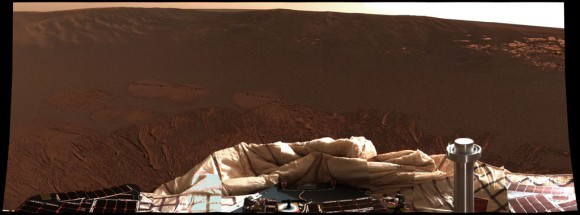
The interior of a crater surrounding the Mars Exploration Rover Opportunity at Meridiani Planum on Mars can be seen in this color image from the rover's panoramic camera. This is the darkest landing site ever visited by a spacecraft on Mars. The rim of the crater is approximately 10 meters (32 feet) from the rover. The crater is estimated to be 20 meters (65 feet) in diameter. Scientists are intrigued by the abundance of rock outcrops dispersed throughout the crater, as well as the crater's soil, which appears to be a mixture of coarse gray grains and fine reddish grains. Data taken from the camera's near-infrared, green and blue filters were combined to create this approximate true color picture, taken on the first day of Opportunity's journey. The view is to the west-southwest of the rover. Credit: NASA/JPL/Cornell
Since 2004, the rover’s longevity has surpassed all expectations and nobody on the science and engineering teams that built and operate the twins can believe they lasted so long and produced so much science.
“We have a new Opportunity overview article publishing shortly in the Journal of Geophysical Research (JGR). The Spirit overview paper appeared recently. In addition, there will be about 24 new scientific papers coming out in the new few months as JGR special issues covering more of the MER results. ”
The incredible longevity is “way beyond the wildest expectations of even the people who built the twin sisters” according to fellow Cornell University Professor Jim Bell. “To say the rovers have surpassed expectations is an understatement. We’ve blown them out of the water”. Bell is the lead scientist responsible for the rovers’ high resolution color imaging system called Pancam.
“After 7 years it is still very exciting,“ Arvidson told me. “I am delighted to come to work every day. It’s great to work on the engineering plan for driving and operating the rovers and then see the results the next day.”
Spirit and Opportunity have accomplished a remarkable series of scientific breakthroughs, far surpassing the wildest dreams of all the researchers and NASA officials. Indeed both Mars rovers are currently stationed at scientific goldmines.
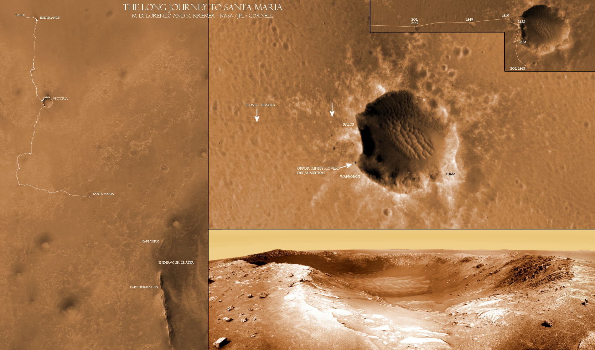
Opportunity is currently exploring the outskirts of the stadium sized ‘Santa Maria’ Carter – some 295 feet wide (90 m) – which holds deposits of water bearing minerals that will further elucidate the potential for habitability on the red planet.
The rover arrived at the western edge of the relatively fresh impact crater on Dec. 16, 2010 (Sol 2451). This intermediate stop on the rovers 19 km long journey from Victoria Crater to giant 22 km wide Endeavour Crater will provide important ground truth observations to compare with the orbital detection of exposures of hydrated sulfate minerals. Read more on Santa Maria in the next feature story.
Santa Maria is just 6 km from the western rim of Endeavour which shows spectral signatures of phyllosilicates, or clay bearing minerals, which formed in water about 4 billion years ago and have never before been directly analyzed on the Martian surface.
Phyllosilicates form in neutral aqueous conditions that could have been more habitable and conducive to the formation of life than the later Martian episodes of more harshly acidic conditions in which the sulfates formed that Opportunity has already been exploring during her 7 year long overland expedition.
Since the moment she landed inside ‘Eagle’ crater, Opportunity has been on a Martian crater tour her entire lifetime.
Opportunity “scored a 300-million mile interplanetary hole in one,” Steve Squyres said at that time, by improbably rolling to a stop smack inside the small 66 foot wide ‘Eagle’ crater (see map) after bouncing across the virtually flat and featureless dusty plains of Meridiani. She has been a lucky princess from the moment of her birth, spying layered sedimentary rocks in a bedrock outcrop from first light in her cameras a mere 26 feet or so away. That’s unlike any previous lander.

Seven days later she drove off the landing pad, drilled into the outcrops and collected the “ground truth” science data to prove that hematite was present and liquid water had indeed flowed at Meridiani as a lake or shallow sea on ancient Mars.
After completing her science campaign, she climbed up and over the rim, departed ‘Eagle’ and arrived at ‘Endurance’ about 3 months after landing day.
After numerous tests, Opportunity was commanded to slowly crawl down into the crater. She gradually descending about 30 vertical feet, frequently drilling into the sedimentary rocks and layers to reveal Mars watery past in unprecedented scientific detail for about six months.
In Dec. 2004, Opportunity departed for “Victoria” crater, which many believed would be her final destination. The robot nearly perished in a sand trap at Purgatory along the way during a nearly two year drive across the treacherous martian sand dunes.
Opportunity arrived in Sept. 2006 to unveil Victoria’s Secrets in color. The rover actually wound up spending two years driving to different vantage points around the rim of and then inside the half mile wide crater before departing in Sept 2008 for the unimaginable goal of giant ‘Endeavour’ crater.
The rover team hopes to reach the slopes of Endeavour sometime later in 2011 if all goes well – before her 8th anniversary !
See below some of the best images taken by Opportunity during her 7 Year Martian Trek

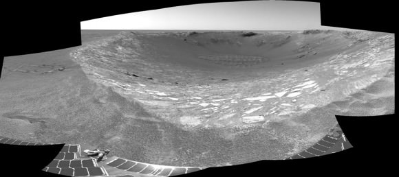
This view looking was taken by the navigation camera on June 6, 2004. That was two sols before Opportunity entered the crater, taking the route nearly straight ahead in this image. This view is a cylindrical projection with geometric seam correction. Credit: NASA/JPL
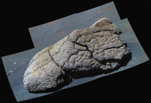
NASA's Mars Exploration Rover Opportunity examined a boulder called Wopmay before heading further east inside Endurance Crater. The frames combined into this false-color view were taken by Opportunity's panoramic camera during the rover's 251st martian day (Oct. 7, 2004). The coloring accentuates iron-rich spherical concretions as bluish dots embedded in the rock and on the ground around it. The rock is about one meter (3 feet) across. Credit: NASA/JPL/Cornell
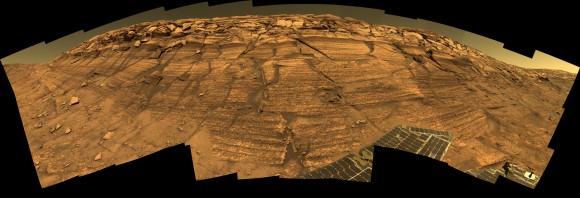
Opportunity captured this view of Burns Cliff after driving right to the base of this southeastern portion of the inner wall of Endurance Crater. The view combines frames taken by Opportunity's panoramic camera between the rover's 287th and 294th martian days (Nov. 13 to 20, 2004). The mosaic spans more than 180 degrees side to side. Because of this wide-angle view, the cliff walls appear to bulge out toward the camera. In reality the walls form a gently curving, continuous surface. Image credit: NASA/JPL/Cornell
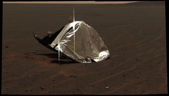
This image from the panoramic camera on NASA's Mars Exploration Rover Opportunity features the remains of the heat shield that protected the rover from temperatures of up to 2,000 degrees Fahrenheit as it made its way through the martian atmosphere. This two-frame mosaic was taken on Sol 335 (Jan. 2, 2005). The view is of the main heat shield debris seen from approximately 10 meters (about 33 feet) away from it. Many rover-team engineers were taken aback when they realized the heat shield had inverted, or turned itself inside out. The height of the pictured debris is about 1.3 meters (about 4.3 feet). The original diameter was 2.65 meters (8.7 feet), though it has obviously been deformed. The Sun reflecting off of the aluminum structure accounts for the vertical blurs in the picture.
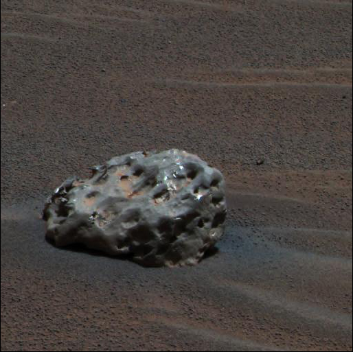
Opportunity finds an iron meteorite on Mars, the first meteorite of any type ever identified on another planet. The pitted, basketball-size object is mostly made of iron and nickel. Opportunity used its panoramic camera to take the images used in this approximately true-color composite on the Sol 339 (Jan. 6, 2005). Credit: NASA/JPL/Cornell
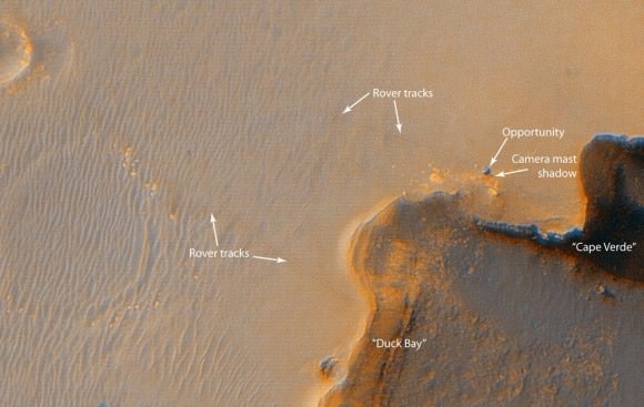
This image from the High Resolution Imaging Science Experiment on NASA's Mars Reconnaissance Orbiter shows the Mars Exploration Rover Opportunity near the rim of Victoria Crater. Victoria is an impact crater about 800 meters (half a mile) in diameter at Meridiani Planum near the equator of Mars. Five days before this image was taken, Opportunity arrived at the rim of Victoria, after a drive of more than 9 kilometers (over 5 miles). It then drove to the position where it is seen in this image. This view is a portion of an image taken by the High Resolution Imaging Science Experiment (HiRISE) camera onboard the Mars Reconnaissance Orbiter spacecraft on Oct. 3, 2006. Credit: NASA/JPL/UA

This Opportunity panorama reveals 2,500 ft-wide, 230 ft-deep Victoria Crater from the lip at Duck Bay alcove. Geologic layers reveal the history of Martian water here. The panorama was taken about 8 feet from the crater rim on Sol 952 (28 Sept 2006) as the rover sat between two steep promontories, Cape Verde and Cabo Frio. This vista exposes a thick stack of geologic layers which revealed the hidden watery secrets of the Martian environment farther back in time than any other location visited previously by the rovers. One can see a ½ mile to the distant cliff walls of the crater, above a windswept dune field in the center. This mosaic was assembled from navcam images and featured in Aviation Week & Space Technology magazine and on the Astronomy Picture of the Day (APOD) on 2 Oct. 2006 in high resolution. Credit: NASA/JPL/Cornell, Bernhard Braun, Marco Di Lorenzo, Kenneth Kremer. http://antwrp.gsfc.nasa.gov/apod/ap061002.html
Check out this spherical projection panorama of Opportunity descending inside Victoria Crater on Sol 1332. Credit: NASA/JPL/Cornell/Nasatech.net

This view of Victoria crater is looking north from Duck Bay towards the dramatic promontory called Cape Verde. The dramatic cliff of layered rocks is about 50 meters (about 165 feet) away from the rover and is about 6 meters (about 20 feet) tall. The taller promontory beyond that is about 100 meters (about 325 feet) away, and the vista beyond that extends away for more than 400 meters (about 1300 feet) into the distance. This is an approximately true color rendering of images taken by the panoramic camera (Pancam) on NASA's Mars Exploration Rover Opportunity during Sol 952 (Sept. 28, 2006) using the camera's 750-nanometer, 530-nanometer and 430-nanometer filters. Credit: NASA/JPL/Cornell
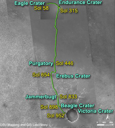
NASA's Mars Exploration Rover Opportunity reached the rim of Victoria Crater on Sept. 28, 2006, Sol 952. Opportunity drove 9.28 kilometers (5.77 miles) in the explorations that took it from Eagle Crater, where it landed in January 2004, eastward to Endurance Crater, which it investigated for about half of 2004, then southward to Victoria.

During four months prior to the fourth anniversary of its landing on Mars, Opportunity examined rocks inside an alcove called Duck Bay in the western portion of Victoria Crater. The main body of the crater appears in the upper right of this panorama, with the far side of the crater lying about 800 meters (half a mile) away. Bracketing that part of the view are two promontories on the crater's rim at either side of Duck Bay. They are Cape Verde, about 6 meters (20 feet) tall, on the left, and Cabo Frio, about 15 meters (50 feet) tall, on the right. This view combines many images taken by Opportunity's panoramic camera (Pancam) from the Sol 1,332 through 1,379. (Oct. 23 to Dec. 11, 2007).
Relive Opportunity’s landing:

I’ve said it before but I hope to visit them in their museum one day.
Mars Rover photos suffer from defects: skew, aspect ratio alterations, contrast defects and false colors. These defects were INSTALLED [at Pinegap AUS, per John Lear] so that Life is not shown on Mars which actually exists there quite plentifully.
Yes, Mars is well-known for its plentiful biosphere.
Foreign governments sneaking in those defects are an absolute disgrace. Maybe it is those evil conspirators modifying the images you are seeing television and through your computers. With such digital technology being so abused, it might be a really good idea to next invade Australia!
Didn’t you know they have already films much of the Mars landings for 2035 just so we don’t see any of these critters running about?
(Shush!! Don’t tell anyone, please, but didn’t you know your President Obama is really a caucasian ten year old girl! You heard it here first!)
WoooooBoogeyBoogey!!!
Please provide me with links explaining your theory – I’d love to see how Pine Gap is involved in all of this, given that they could have doctored the cameras in the US where the rovers were actually built.
Incidentally – why did they build the rovers and send them to Mars only to doctor the pictures to hide what is in them? Why not just not send the rovers at all? Actually don’t worry – have another bong.
I am just HANGING to see this thing get to Endeavour. What a spectacular achievement for mankind.