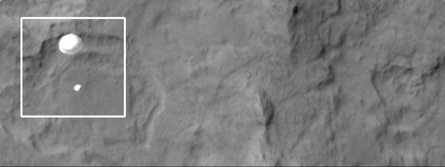
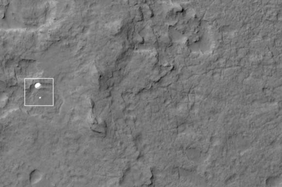
The HiRISE team has outdone themselves this time. Using their incredible instrument, the High Resolution Imaging Science Experiment, they have captured an absolutely amazing image of the Curiosity rover, descending on a parachute through Mars’ atmosphere.
“Nailed it!” Tweeted Christian Schaller of the HiRISE team. “My goodness, @MarsCuriosity you look pretty.”
Wow!
Link to original image (2.7 MB)
Schaller told Universe Today that the MSL Navigation team, the MRO Navigation team and the MRO FET (flight engineering team) “seriously rock. Seriously.”
The planning by those teams made this image possible.
Schaller is the software developer responsible for the primary planning tools the MRO and HiRISE targeting specialists and science team members use to plan their images.
“The Mars background looks a little blurry or smeared because we set up the timing to capture Curiosity, not the Martian surface,” Schaller said via email after the image was released at the press conference from JPL on Monday morning.
The image was set up so that as MSL was descending, MRO “slewed” the HiRISE field of view across the expected descent path. But obviously, MRO didn’t have to slew too much. “We were almost directly overhead, and had a very, very small angle to take the image,” said HiRISE team member Sarah Malkovich at the press conference. “MRO was essentially overhead.”
HiRISE Principal Investigator Alfred McEwen said before the landing that they expected only a 60% chance of success.
McEwen wrote the HiRISE website of the image:
The parachute appears fully inflated and performing perfectly. Details in the parachute such as the band gap at the edges and the central hole are clearly visible. The cords connecting the parachute to the backshell cannot be seen, although they were seen in the image of Phoenix descending, perhaps due to the difference in lighting angles.
The bright spot on the backshell containing MSL might be a specular reflection off of a shiny area. MSL was released from the backshell sometime after this image was acquired.
This view is one product from an observation made by HiRISE targeted to the expected location of MSL about 1 minute prior to landing. It was captured in HiRISE CCD RED1, near the eastern edge of the swath width (there is a RED0 at the very edge). This means that MSL was a bit further east or downrange than predicted.
The image scale is 33.6 cm/pixel.
MRO was 340 km away from Curiosity when the image was taken, and that is line of sight distance, said Malkovich. “HiRISE has taken over 120 pictures of Gale Crater in preparation for MSL’s mission, but I think this is the coolest one,” she said.
McEwen said more details and image products will be available and we will post them as soon as they are available.
This animation shows how HiRISE planned to capture MSL’s descent:
Malkovich said that the HiRISE team already has plans to take images of Curiosity sitting on the surface of Mars later this week that will be of higher resolution than the descent image.


Congratulations HiRISE Team !
Wowza!
Take a look at the Lawman
Beating up the wrong guy
Oh man! Wonder if he’ll ever know
He’s in the best selling show
Is there life on Mars?
It is an example of the remarkable time we live in.
LC
Ditto on lcrowell’s statement! I’m thinking of all the calculations required to time the arrival of both the MRO and Curiosity and then accurately point the camera’s aboard MRO… Wowie! That’s some trick pony! HO@!
If you want to get some feel for what it’s like to
be a flight controller watching telemetry from Curiosity, download
NASA’s next-generation mission operations software, Mission Control
Technologies (MCT). My team at NASA Ames Research Center recently made
it open source under the Apache 2.0 license. The demo version can be
downloaded and run with no computer knowledge, and does almost
everything that the full version does, except save the displays you
create. (Sorry, the demo version shows only fake data, though we are
working on a plugin to let you see a small amount of real ISS data.)
JPL’s Curiosity team will not be using MCT initially, because we had
it ready too late for their schedule, but MCT’s views are similar to the
views of the software that the Curiosity flight controllers are using,
so you can get some idea. We have even built the data adapter so MCT can
show Curiosity data, and have demonstrated it at JPL. On our web site
there is also a three-minute overview video and a Quick Start Guide. Be
sure to plug in the example plugins from the Plug Ins page! Find our web
site by searching the internet for “NASA open MCT”. Also check out our
blog, which is linked from our web site.