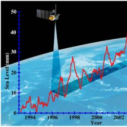
Artist illustration of NASA satellite measuring sea levels. Image credit: NASA/JPL. Click to enlarge.
For the first time, NASA has the tools and expertise to understand the rate at which sea level is changing, some of the mechanisms that drive those changes and the effects that sea level change may have worldwide.
“It’s estimated that more than 100 million lives are potentially impacted by a one-meter (3.3-foot) increase in sea level,” said Dr. Waleed Abdalati, head of the Cryospheric Sciences Branch at NASA’s Goddard Space Flight Center, Greenbelt, Md. “When you consider this information, the importance of learning how and why these changes are occurring becomes clear,” he added.
Although scientists have directly measured sea level since the early part of the 20th century, it was not known how many of the observed changes in sea level were real and how many were related to upward or downward movement of the land. Now satellites have changed that by providing a reference by which changes in ocean height can be determined regardless of what the nearby land is doing. With new satellite measurements, scientists are able to better predict the rate at which sea level is rising and the cause of that rise.
“In the last 50 years sea level has risen at an estimated rate of .18 centimeters (.07 inches) per year, but in the last 12 years that rate appears to be .3 centimeters (.12 inches) per year. Roughly half of that is attributed to the expansion of ocean water as it has increased in temperature, with the rest coming from other sources,” said Dr. Steve Nerem, associate professor, Colorado Center for Astrodynamics Research, University of Colorado, Boulder.
Another source of sea level rise is the increase in ice melting. Evidence shows that sea levels rise and fall as ice on land grows and shrinks. With the new measurements now available, it’s possible to determine the rate at which ice is growing and shrinking.
“We’ve found the largest likely factor for sea level rise is changes in the amount of ice that covers the Earth. Three-fourths of the planet’s freshwater is stored in glaciers and ice sheets or the equivalent of about 67 meters (220 feet) of sea level,” said Dr. Eric Rignot, principal scientist for the Radar Science and Engineering Section at NASA’s Jet Propulsion Laboratory, Pasadena, Calif. “Ice cover is shrinking much faster than we thought, with over half of recent sea level rise due to the melting of ice from Greenland, West Antarctica’s Amundsen Sea and mountain glaciers,” he said.
Additionally, NASA scientists and partner researchers now are able to measure and monitor the world’s waters globally in a sustained and comprehensive way using a combination of satellite observations and sensors in the ocean. By integrating the newly available satellite and surface data, scientists are better able to determine the causes and significance of current sea level changes.
“Now the challenge is to develop an even deeper understanding of what is responsible for sea level rise and to monitor for possible future changes. That’s where NASA’s satellites come in, with global coverage and ability to examine the many factors involved,” said Dr. Laury Miller, chief of the National Oceanic and Atmospheric Administration Laboratory for Satellite Altimetry, Washington, D.C.
NASA works with agency partners such as the National Oceanic and Atmospheric Administration and the National Science Foundation to explore and understand sea level change. Critical resources that NASA brings to bear on this issue include such satellites as:
— Topex/Poseidon and Jason, the U.S. portions of which are managed by JPL, which use radar to map the precise features of the oceans’ surface, measuring ocean height and monitoring ocean circulation;
— Ice, Cloud and Land Elevation Satellite (IceSat), which studies the mass of polar ice sheets and their contributions to global sea level change;
— Gravity Recovery And Climate Experiment (Grace), also managed by JPL, which maps Earth’s gravitational field, allowing us to better understand movement of water throughout the Earth.
Original Source: NASA News Release
