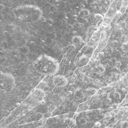
Dione’s icy surface. Image credit: NASA/JPL/SSI Click to enlarge
Dione’s icy surface is scarred by craters and sliced up by multiple generations of geologically-young bright fractures. Numerous fine, roughly-parallel linear grooves run across the terrain in the upper left corner.
Most of the craters seen here have bright walls and dark deposits of material on their floors. As on other Saturnian moons, rockslides on Dione (1,126 kilometers, or 700 miles across) may reveal cleaner ice, while the darker materials accumulate in areas of lower topography and lower slope (e.g. crater floors and the bases of scarps).
The terrain seen here is centered at 15.4 degrees north latitude, 330.3 degrees west longitude, in a region called Carthage Linea. North on Dione is up and rotated 50 degrees to the left.
The image was taken in visible green light with the Cassini narrow-angle camera on Oct. 11, 2005, at a distance of approximately 19,600 kilometers (12,200 miles) from Dione. The image scale is about 230 meters (760 feet) per pixel.
The Cassini-Huygens mission is a cooperative project of NASA, the European Space Agency and the Italian Space Agency. The Jet Propulsion Laboratory, a division of the California Institute of Technology in Pasadena, manages the mission for NASA’s Science Mission Directorate, Washington, D.C. The Cassini orbiter and its two onboard cameras were designed, developed and assembled at JPL. The imaging operations center is based at the Space Science Institute in Boulder, Colo.
For more information about the Cassini-Huygens mission visit http://saturn.jpl.nasa.gov . The Cassini imaging team homepage is at http://ciclops.org .
Original Source: NASA/JPL/SSI News Release
