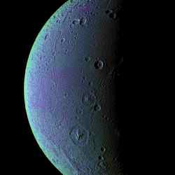
False colour view of Dione. Image credit: NASA/JPL/SSI Click to enlarge
This view highlights tectonic faults and craters on Dione, an icy world that has undoubtedly experienced geologic activity since its formation.
To create the enhanced-color view, ultraviolet, green and infrared images were combined into a single black and white picture that isolates and maps regional color differences. This “color map” was then superposed over a clear-filter image. The origin of the color differences is not yet understood, but may be caused by subtle differences in the surface composition or the sizes of grains making up the icy soil.
This view looks toward the leading hemisphere on Dione (1,126 kilometers, or 700 miles across). North is up and rotated 20 degrees to the right.
See Dione Has Her Faults (Monochrome) for a similar monochrome view.
All images were acquired with the Cassini spacecraft narrow-angle camera on Dec. 24, 2005 at a distance of approximately 151,000 kilometers (94,000 miles) from Dione and at a Sun-Dione-spacecraft, or phase, angle of 99 degrees. Image scale is 896 meters (2,940 feet) per pixel.
The Cassini-Huygens mission is a cooperative project of NASA, the European Space Agency and the Italian Space Agency. The Jet Propulsion Laboratory, a division of the California Institute of Technology in Pasadena, manages the mission for NASA’s Science Mission Directorate, Washington, D.C. The Cassini orbiter and its two onboard cameras were designed, developed and assembled at JPL. The imaging operations center is based at the Space Science Institute in Boulder, Colo.
For more information about the Cassini-Huygens mission visit http://saturn.jpl.nasa.gov . The Cassini imaging team homepage is at http://ciclops.org .
Original Source: NASA/JPL/SSI News Release
