Spectacular imagery of huge regions of flowing ice, monumental mountain ranges and a breathtakingly backlit atmospheric haze showing Pluto as we’ve never seen it before, were among the newest discoveries announced today, July 24, by scientists leading NASA’s New Horizons mission which sped past the planet for humanity’s first ever up-close encounter only last week.
New Horizon’s revealed Pluto be an unexpectedly vibrant “icy world of wonders” as it barreled by the Pluto-Charon double planet system last Tuesday, July 14, at over 31,000 mph (49,600 kph).
The scientists publicly released a series of stunning new images and science discoveries at Pluto that exceeded all pre-flyby expectations.
“The images of Pluto are spectacular,” said John Grunsfeld, NASA’s associate administrator for the Science Mission Directorate, at today’s media briefing.
“We knew that a mission to Pluto would bring some surprises, and now — 10 days after closest approach — we can say that our expectation has been more than surpassed. With flowing ices, exotic surface chemistry, mountain ranges, and vast haze, Pluto is showing a diversity of planetary geology that is truly thrilling.”
Over 50 gigabits of data were collected during the encounter and flyby periods of the highest scientific activity in the most critical hours before and after the spacecrafts closest approach to Pluto, its largest moon Charon and its quartet of smaller moons.
Data from the flyby is now raining back to Earth, but slowly due to limited bandwidth of an average “downlink” of only about 2 kilobits per second via its two transmitters.
“So far we’ve seen only about 5% of the encounter data,” said Jim Green, director of Planetary Science at NASA Headquarters in Washington.
At that pace it will take about 16 months to send all the flyby science data back to Earth.
Among the top highlights is the first view ever taken from the back side of Pluto, a backlit view that humans have never seen before.
It shows a global portrait of the planets extended atmosphere and was captured when NASA’s New Horizons spacecraft was about 1.25 million miles (2 million kilometers) from Pluto. It shows structures as small as 12 miles across.
“The silhouette of Pluto taken after the flyby and show a remarkable haze of light representing the hazy worlds extended atmosphere,” Alan Stern, principal investigator for New Horizons at the Southwest Research Institute (SwRI) in Boulder, Colorado, said at the media briefing.
“The image is the equivalent of the Apollo astronauts Earth-rise images.”
“It’s the first image of Pluto’s atmosphere!” said Michael Summers, New Horizons co-investigator at George Mason University in Fairfax, Virginia, at the briefing.
“We’ve known about the atmosphere for over 25 years,” and now we can see it. There are haze layers and it shows structure and weather. There are two distinct layers of haze. One at about 30 miles (50 kilometers) and another at about 50 miles (80 kilometers) above the surface.”
“The haze extend out about 100 miles! Which is five times more than expected.”
The image was taken by New Horizons’ high resolution Long Range Reconnaissance Imager (LORRI) while looking back at Pluto, barely seven hours after closest approach at 7:49 a.m. EDT on July 14, and gives significant clues about the atmosphere’s dynamics and interaction with the surface. It captures sunlight streaming through the atmosphere.
“The hazes detected in this image are a key element in creating the complex hydrocarbon compounds that give Pluto’s surface its reddish hue.”
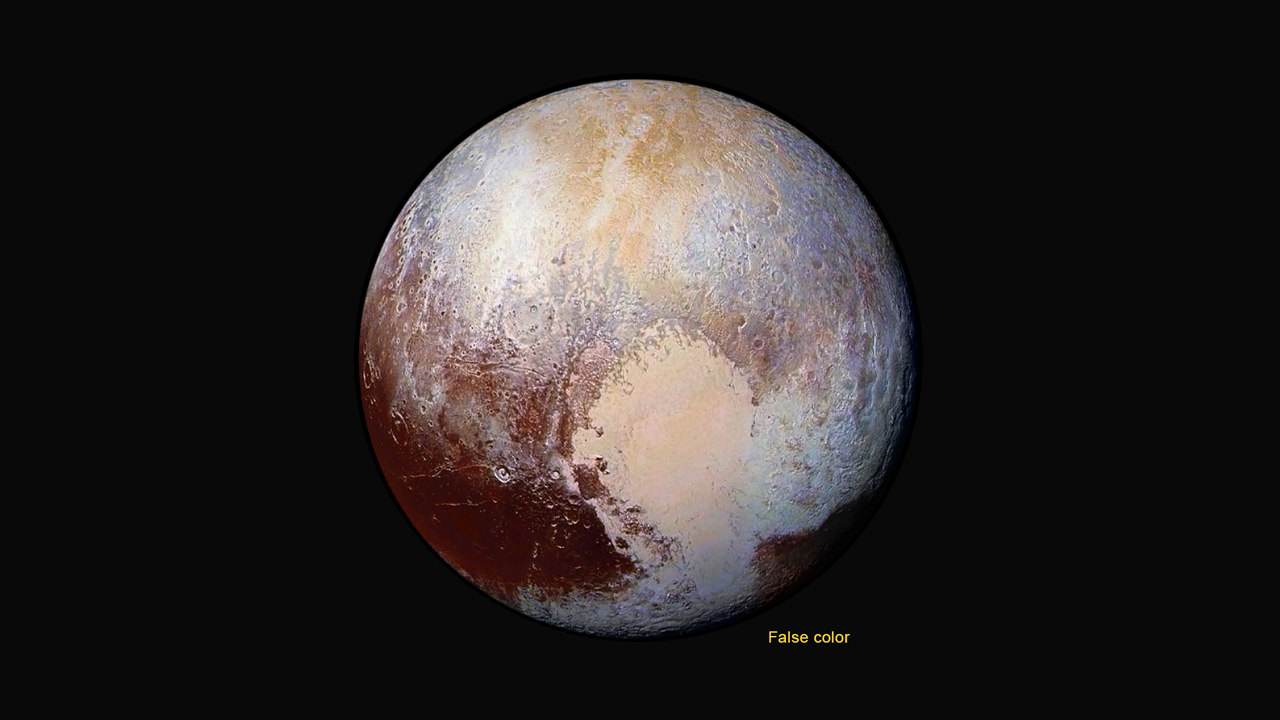
Methane (CH4) in the upper atmosphere break down by interaction of UV radiation and forms ethylene and acetylene which leads to more complex hydrocarbons known as tholins – which the team says is responsible for Pluto’s remarkable reddish hue.
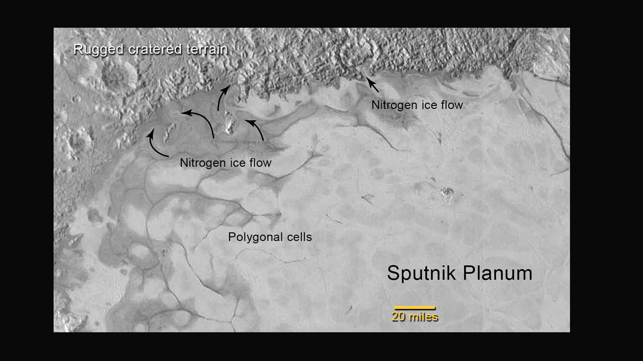
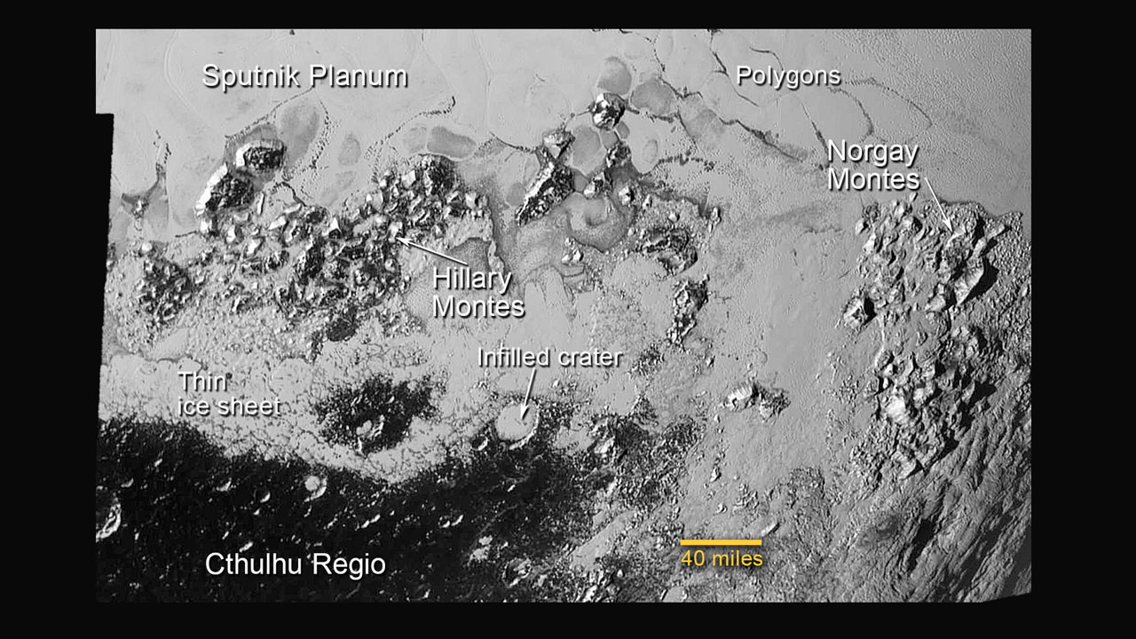
The team also released new LORRI images showing “extensive evidence of exotic ices flowing across Pluto’s surface and revealing signs of recent geologic activity, something scientists hoped to find but didn’t expect.”
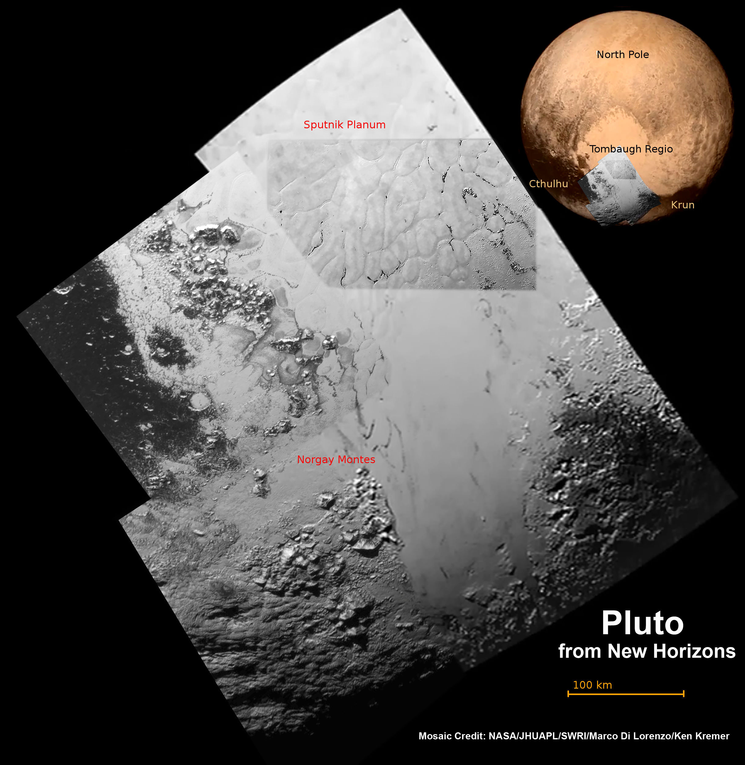
The images focuses on Sputnik Planum, a Texas-sized plain, which lies on the western, left half of Pluto’s bilobed and bright heart-shaped feature, known as Tombaugh Regio.

New imagery and spectral evidence from the Ralph instrument was presented that appears to show the flow of nitrogen ices in geologically recent times across a vast region. They appear to flow similar to glaciers on Earth. There are also carbon monoxide and methane ices mixed in with the water ices.
“We’ve only seen surfaces like this on active worlds like Earth and Mars,” said mission co-investigator John Spencer of SwRI. “I’m really smiling.”
“At Pluto’s temperatures of minus-390 degrees Fahrenheit, these ices can flow like a glacier,” said Bill McKinnon, deputy leader of the New Horizons Geology, Geophysics and Imaging team at Washington University in St. Louis.
“In the southernmost region of the heart, adjacent to the dark equatorial region, it appears that ancient, heavily-cratered terrain has been invaded by much newer icy deposits.”
“We see the flow of viscous ice that looks like glacial flow.”
If the spacecraft remains healthy as expected, the science team plans to target New Horizons to fly by another smaller Kuiper Belt Object (KBO) as soon as 2018.
Watch for Ken’s continuing coverage of the Pluto flyby. He was onsite reporting live on the flyby and media briefings for Universe Today from the Johns Hopkins University Applied Physics Laboratory (APL), in Laurel, Md.
Stay tuned here for Ken’s continuing Earth and planetary science and human spaceflight news.


Grrrreat!
Is there a lab on Earth that can duplicate that negative 390 degrees in a chamber of any real size? I’m thinking large enough to provide images of mixtures of materials of a large enough scale to replicate Pluto’s “glaciers”.
As I look at the new false color image, looking west of tombaugh reggio there appears to be three impact craters moving to the left, just above the dark equator. Could tombaugh reggio be the result of a massive impact, wherein the frozen surface liquified and refroze? Looking down and right from tombaugh reggio there appears to be somewhat of a spray pattern. Maybe it’s just me though.
“The image is the equivalent of the Apollo astronauts Earth-rise images.”
I’m not a lunar lander denier. Maybe just confused. When the Moon is tidally locked to the Earth how does it then rise from the moons perspective. Were those just feel good pictures that really don’t happen; Earth doesn’t rise on the Moon?
The orbital movement of the spacecraft created the illusion of the Earth rising.
The image was taken while standing on the Moon’s surface, so no.
Yes, our photo’s standing on the moon can’t be an Earth rise; only from the lunar orbiter!
It was taken from orbit… oops, my bad.
From Wikipedia: “An earthrise that might be witnessed from the surface of the Moon would be quite unlike moonrises on Earth. Because the Moon is tidally locked with the Earth, one side of the Moon always faces toward Earth. Interpretation of this fact would lead one to believe that the Earth’s position is fixed on the lunar sky and no earthrises can occur, however, the Moon librates slightly, which causes the Earth to draw a Lissajous figure on the sky. This figure fits inside a rectangle 15°48′ wide and 13°20′ high (in angular dimensions), while the angular diameter of the Earth as seen from Moon is only about 2°. This means that earthrises are visible near the edge of the Earth-observable surface of the Moon (about 20% of the surface). Since a full libration cycle takes about 27 days, earthrises are very slow, and it takes about 48 hours for Earth to clear its diameter.[14] During the course of the month-long lunar orbit, an observer would additionally witness a succession of “Earth phases”, much like the lunar phases seen from Earth. That is what accounts for the half-illuminated globe seen in the photograph.”
OK, I was thinking the moon rise was on the surface of the moon not from the spacecraft. And, the moon does rise if your in the right spot and stay long enough and survive. And, Ken’s point that it was a new perspective of a planet never seen in a photograph before.
Is there any indication that the atmosphere is elongated to point at Charon?
I’ll wager that the source of the nitrogen that formed the ice glaciers and the entire Tombaugh Regio, was scoured from the dark areas below during ‘seasonal’ changes. Whereas the northern summers and autumns are ~80 years long and the winter and springtimes are ~40 years long. Plenty of time for massive transport of gaseous materials to migrate… Why does the Tombaugh Regio appear where it does? Donno.. cept a comparison to Greenland or the Tibetan plateau might indicate higher elevation as culpret?