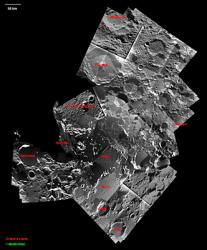
Mention the North Pole this time of year and perhaps what comes to mind are visions of snowy, candy cane-lined streets leading to a candle-lit workshop. But how about sun-drenched regolith dotted with craters cast in permanent shadows? Those are the types of images revealed in a new detailed map of the north pole — on the moon.
A mosaic created from data obtained by the SMART-1 spacecraft shows detailed features of the geography and illumination of the lunar north pole. These maps can be used by future explorers as an aid for traveling and traversing on the moon.
The lunar poles are of interest for science and the upcoming exploration of the moon mainly because of their exposure to sunlight. There are areas that are continually bathed in sunlight, but within craters in the same region are dark areas that rarely receive any light, and therefore could contain water ice. Both these aspects would be important for potential lunar base sites.
“Solar illumination makes these areas ideal for robotic outposts or lunar bases making use of solar power, ” said the European Space Agency’s Bernard Foing, who is Project Scientist for the SMART-1 Spacecraft.
Any water ice on the moon would be useful for the inhabitants of a lunar base.
The SMART-1 north pole map covers an area of about 800 by 600 km and shows the geographical locations of several craters. Of special interest is Peary Crater, the largest impact crater that is close to the lunar north pole. At this latitude the interior of the crater receives little sunlight, but SMART-1 was able to observe it during phases when the crater floor was sufficiently illuminated for imaging.
Also imaged was Crater Plaskett, located on the northern far side of the moon, about 200 kilometers from the north pole. Because of the location of this crater it receives sunlight at a low angle and it has been suggested as a lunar base that could be used for a possible analog to simulate conditions of a manned mission to Mars.
Foing also said that the discovery of water ice on the moon could help us understand Earth’s history as well. “If the layers of ice come from the volatiles deposited by comets or water-rich asteroids, we could better understand how, and how much, water and organic material was delivered to Earth over its history,” he said.
Using electric propulsion navigation, SMART-1 reached lunar orbit in November of 2004 and performed a year and a half of scienctific observations. The mission ended with a controlled impact on the moon’s surface in September of 2006.
The polar mosaics were presented and discussed at the 9th International Lunar Exploration Working Group (ILEWG) lunar conference in October 2007.
SMART-1 science investigations include studies of the chemical composition of the Moon, of geophysical processes such as volcanism, tectonics, cratering, and erosion, and high resolution studies in preparation for future steps of lunar exploration.
Original News Source: ESA Press Release

