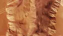
The photographs coming back from the Martian orbiters sure help you appreciate the very different terrain on the Red Planet. And here’s an example of one of the extreme places on Mars: the Valles Marineris the deepest, longest valley in the Solar System. The image was captured by ESA’s Mars Express spacecraft and reveals a region of the valley called Candor Chasma.
Take a look at a photograph of Mars, and it’s easy to spot Valles Marineris. It’s a 3,000 km-long (1,800 mile) gash carved in the side of the Red Planet. Planetary geologists think it formed around the same time as the nearby Tharsis Bulge – the volcanic region that houses Olympus Mons, the largest mountain in the Solar System.
It’s likely a rift valley, similar to the East African Rift Valley here on Earth. As the giant volcanoes formed, the Valles Marineris opened up as a crack in the ground. Flowing carbon dioxide could have weathered it further, eroding it and forcing the walls to cave in.
As I mentioned above, this is just a tiny portion of the whole rift. The canyon walls tower 8,500 metres (28,000 feet) above the floor below.
And if there was one place in the whole Solar System that I could travel to and see with my own eyes, it would be right here. So come on NASA, hurry up with that mission to Mars already.
Original Source: ESA News Release


Cool… wish I could come with you on that trip Fraiser!!!
It’s somewahat like the Grand Canyon, but larger
A magnificent picture, just plain awesome, I wanna go too!
You guys can have fun suffocating on Mars, I’ll stick with some place warm in the tropics 😛
A good place to look for evidence of past life.
To get a REAL good look, you’d
probably need something like an autonomous zeppelin or other
aircraft. A lander (or climber) alone
wouldn’t be as handy to survey all
that stuff.
“Jeff Says:
February 19th, 2008 at 7:20 pm
It’s somewahat like the Grand Canyon, but larger”
Not really. The Grand Canyon is a water erosion formation. Valles Marinaris is a rift. Quite different.
I wonder if the atmospheric pressure is significantly greater at the bottom of the chasm. If it were, might be a good place to put a manned base of some type.
Spoken like a true explorer Alan.
The great explorers all seem to look at things slightly differently than the rest of us.
A tourists view would probably be from the top looking down , while an explorer would be looking from the bottom up.
At the very least, it would be a magnificent view either way.
anyone ever read “Mars Earth Wars” by geologist Donald Patton? very fascinating & compelling theories about how all of this was formed including not only theses features of the Tharsis Bulge but also the Helles crater situated on the opposite side of the planet which just happens to be the largest known Impact Crater in the solar system.
Such a valley would lead to some quite extreme atmospheric conditions between bottom and top when combined with different lengths of sunlight and heating on the various surfaces. Any human “pod” or capsule would be subject to extreme heating and cooling, expansion of gases and sublimation of CO2. An interesting place to model!
There’s a lot of pressure difference between the bottom of Death Valley and the top of Mt. Whitney. Wonder what the pressure gradient would be from the bottom of Valles Marinaris and the mean surface of Mars?