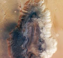
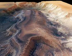
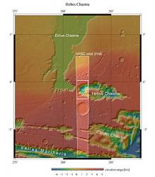
This breathtaking 3D landscape was constructed with high definition images taken by the High Resolution Stereo Camera (HRSC) on board ESA’s Mars Express orbiter. The new observations show Hebes Chasma, a strange mountain region nested inside the canyon, with channel-like fingers reaching out into the Martian landscape. The imaged region shows features down to a resolution of 15 meters per pixel, an awe-inspiring view… in stereo!

The HRSC is currently looking down onto the Red Planet’s surface, taking shots of the planet in full colour, in 3D and with a maximum resolution of two meters. The camera design allows it unrivalled pointing accuracy by combining images at different resolutions at each orbital pass. By imaging the landscape at three different wavelengths (i.e. three colours), a stereoscopic view of Mars features give observers an insight to how the canyon will look from different angles, in 3D models.
Hebes Chasma is a very prominent Mars feature just north of the huge Valles Marineris system (a.k.a. the “Grand Canyon of Mars”). Hebes is described as an enclosed trough, with a high, flat-top mountain range right in the centre. The canyon is over 8 km deep in places, and the central mountain ascends to this height, at the same level as the surrounding plains. There is evidence to suggest that liquid water once flowed here, possibly creating a vast moat around the mountain, leaving its top isolated when the canyon was full of water. If this natural formation was found on Earth in medieval times, I couldn’t think of a better defended castle if it was built on the apex of this 8 km high range…
A number of huge images have been released, and here are links to a few of the best:
- The entire Hebes Chasma at a resolution of 15 meters/pixel (1.2 MB .jpg)
- 3D anaglyph image of the canyon (1.6 MB .jpg) – Go make your 3D glasses!
- An oblique-angle reconstruction view of the central mountain range (1.6 MB .jpg)
I can’t wait to see more Mars features in stunning 3D projections…
Source: ESA


“I can’t wait to see more Mars features in stunning 3D projections…”
Yeah – I hope they make an IMAX 3D movie of all of this stuff…
They are stunning, can’t wait to see Mars’ surface fully modeled and have a poke around!
I can’t wait to see more Mars features in stunning 3D projections…
They have quite a few more. Just check the Mars Express Image Browser at http://www.esa.int/SPECIALS/Mars_Express/SEMVZF77ESD_0.html
and have fun.
I can’t wait to see the new Rolling Stones movie…
Absolutely stunning, and thanks to the BA for linking to this.
Minor quibble, though – in the final paragraph: “There is evidence to suggest that liquid water once flowed here, possibly creating a vast mote around the mountain, leaving its top isolated when the canyon was full of water.”
I think that should be “moat.”
It would be interesting to see spectrographic or radiometric data of some type across this structure. The apparent smooth shape of the central mountain suggests a batholithic like origin to me – i.e that it was formed by the upwelling of interior magma that did not reach the surface and was exposed by later fracturing and erosion of the overlying material. Erosion appears to have affected the lighter coloured country rock surrounding the Chasma differently than the darker central ‘mountain’. I wonder if that ‘mountain’ is composed of a harder ‘basaltic like’ material. Perhaps some future geologist will find a bit of the Martian mantle here!
Totally right, mote -> moat. Was typing too quick… corrected.
Thanks, Ian
No argument ,the pictures are out of this world, but please enlighten me and explain what on Earth (or Mars this time around ) exactly is a “MOTE” as I can only make out a feature that I would call a “MOAT” similar to barriers that were placed around medieval castles and similar structures.
Please keep the excellent art works coming.
Stunning is the word that comes to mind when looking at these photos.
I also enjoyed the comments posted by ScepticTim these insight to the possible origins of the structures is very informative.
Just the place to look for evidence of past life?
8 Kms is 26,000 feet deep. Adiabatic lapse rate means the atmosphere at the bottom will be some 70 degrees Centigrade warmer than at the rim. Add to that the difference in colour between the two sides, the sunlit side being white must be caused by the heating effects of the sun on that side. That in turn will displace a large atmospheric movement up that sunlit side, as it does on any mountain here on earth with many related effects. For these reasons alone, this must the bottom of the chasm the best possible location for a manned mission to Mars. If we are to find any sign of life on Mars, this must surely be the most likely location?
Again, look at the upper left rim where there is a object that has “sloughed” into the channel leading to the rim edge. Is that a meteorite that, having been just under the surface, is now about to slide into the chasm?
Again, the impact craters on the left have still got signs of the displacement of the surface surrounding the crater, but the ones on the right have lost all that displacement. Is the surface a mixture of ice and soil?
Such photographs are a wonderful way to define future observational missions.
I am glad to see ESA is releasing some really astounding stuff. I have complained to several ESA administers about the long delay in releasing pictures and info. but all I get is “policy”. NASA/JPL is most generous in releasing anything really new within day’s but ESA takes month’s. Don’t get me wrong for I am most appreciative of any information/items put out for revue but I feel it could come a little quicker through the “pipeline”.
Please learn the difference between a moat which surrounds a castle and a mote which is very small like a period.
Looks like fossilized bandersnatch to me.
Wonder why very few if any craters in the chasm and flat-top mountain vs the plains?
Too wild to believe. I have a ? What is the black smooth looking stuff. looks like volcanic glass or something blew up in there and spread it around. Even @ the high elevations. Crazy
I think I will sue for taking such nice pictures of Mars. It may jeopardize our relationship with the Martians.
Oh wait, I’m not from Hawaii.
Now THAT is where a rover needs to go! We’ve got to stop sending rovers to relatively boring places just because they offer safe landing. The bottom of a chasm like this is the place to find something, not the middle of a basically barron desert. We have a lot of smart creative people who can certainly figure out a way to get a robotic mission safely in there or in Valles Marineris. Higher temps, higher pressure, deeper and likely more “moist” . . . what are we wating for?
Just after the Spirit and Opportunity 3D pictures started coming out, JPL published instructions on how to make your own 3D images:
marsrovers.jpl.nasa.gov/spotlight/3d01.html
If you have any experience with photoshop, you can make really cool pictures in only a couple of minutes. You think your brain hurts when you first put on the 3D glasses? See what happens as you alter the depth of the image – ouch!
A wonderful place to see and visit, but we should take care what we do in there. I often think about future life on Mars. We should take care and keep the Red Planet as green as possible.
Hey now, it’s not April Fools Day yet. Too bad they didn’t catch the deepest point just below the range of the second picture.
IT IS SAD THAT WE HAVE SPENT BILLIONS IN FIGHTING EACH OTHER INSTEAD OF COMPLETING OUR DESTINY TO EXPLORE OTHER WORLDS AND GO WHERE MAN HAS NEVER BEEN BEFORE. INSTEAD OF FIGHTING OVER SCRAPS WE SHOULD BE EXPLORING THE INCREDIBLE BOUNTY THE UNIVERSE HAS TO OFFER MANKIND. WHERE IS THE SPIRIT OF EXPLORATION THAT OUR ANCESTORS HAD?
Wow! – Can you imagine the next Mars fps (first person shooter) computer game to be released, Doom 10.0?
I need a bigger monitor!
😉
tambo
It probably is volcanic.
I’d guess the only way a geological feature like this could be formed is through a smack from a large asteroid, there would be plenty of energy (heat) to melt/scorch the rock.
Thanks Ian for not taking my jibe re MOTE too seriously……………….keep up the great work
Stunning, stunning, stunning!
My word it’s beautiful!
I’m well and trruly gobsmacked! These images are amazing, breathtaking!
Thanks for all the knowledgable comments chaps!
Astounding, wonderful images!
Keep up the great work! 🙂