Northern Canada has been keeping a secret from the rest of the world. It’s home to “Resurrection,” a tectonic plate that has been much theorized but never found until now. A team of researchers used what amounts to a CAT scan of northern Canada and the mantle underneath it to find the missing plate.
Finding it could lead to better hazard prediction and also to finding mineral and hydrocarbon deposits. But better than that, it’s helping scientists piece together Earth’s history.
A missing tectonic plate is like a missing puzzle piece. Without it, our understanding of the big picture is compromised. Some scientists say it never existed in the first place, while others say it was subducted into the Earth’s mantle between 40 million and 60 million years ago. But now it appears it’s been found.
“We believe we have direct evidence that the Resurrection plate existed.”
Spencer Fuston, Geology Doctoral Student, University of Houston.
The paper presenting this new result is titled “Raising the Resurrection plate from an unfolded-slab plate tectonic reconstruction of northwestern North America since early Cenozoic time.” The authors are Spencer Fuston and Jonny Wu from the University of Houston College of Natural Sciences and Mathematics. The paper is published in the Geological Society of America Bulletin.
“Volcanoes form at plate boundaries, and the more plates you have, the more volcanoes you have,” said co-author Jonny Wu, assistant professor of geology in the Department of Earth and Atmospheric Sciences. “Volcanoes also affect climate change,” Wu said in a press release. “So, when you are trying to model the earth and understand how climate has changed since time, you really want to know how many volcanoes there have been on earth.”
Piecing together the history of the Earth is very challenging. Volcanic activity is heavily implicated in historical climate change and also in mass extinctions. The Earth’s worst mass extinction event, called the Permian-Triassic Extinction, or the Great Dying, was triggered by massive, sustained eruptions in Siberia about 252 million years ago. So a missing tectonic plate could be a missing clue in the mystery of Earth’s geologic past.
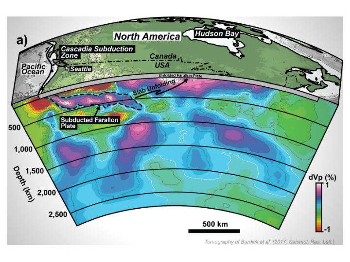
The University of Houston Center for Tectonics and Tomography developed a type of imaging called slab unfolding. There are many types of tomography, but they all image things in sections. Co-author Wu is part of the effort to develop a way to take 3D seismic tomography images and unfold them. The method places constraints on plate tectonic reconstructions. Wu and a separate team of researchers used the method to reconstruct the Philippine Sea and East Asian plate tectonics since 52 mya.
When a plate is subducted back to the mantle, it becomes a folded slab. Tomography can image those folded structures, and the slab unfolding technique can pull out the plate, then unfold them and stretch them back to their original shape.

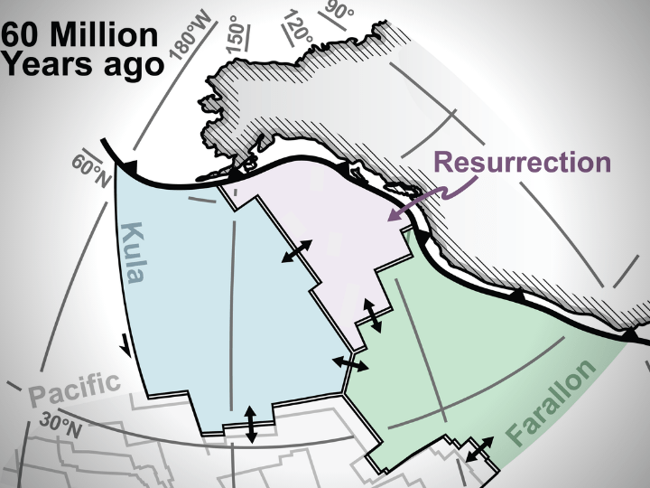
Now Wu and his colleague Fuston, a third-year geology doctoral student, have used slab unfolding to reconstruct the tectonic plates in the Pacific Ocean during the early Cenozoic Era. Geologists know that there were at least two plates in the Pacific, called Kula and Farallon. A third plate called Resurrection was proposed to explain a special type of volcanic belt along Alaska and Washington State. Until now, there was only weak evidence.
“We believe we have direct evidence that the Resurrection plate existed. We are also trying to solve a debate and advocate for which side our data support,” Fuston said.
“When ‘raised’ back to the earth’s surface and reconstructed, the boundaries of this ancient Resurrection tectonic plate match well with the ancient volcanic belts in Washington State and Alaska, providing a much sought after link between the ancient Pacific Ocean and the North American geologic record,” explained Wu.
More:
- Press Release: Lost and Found: UH Geologists ‘Resurrect’ Missing Tectonic Plate
- Research Paper: Raising the Resurrection plate from an unfolded-slab plate tectonic reconstruction of northwestern North America since early Cenozoic time
- Universe Today: What Cracked the Earth’s Outer Shell and Started its Plate Tectonics?

