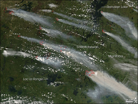

Wildfire season is underway in the northern hemisphere, and with hot and dry conditions in many areas this summer, fires have been plentiful. Regions affected include central Canada, California in the US, Southeastern Russia and Norway. While wildfires are a natural part of Earth’s environment when sparked by lightning strikes, these fires consume a million or more square kilometers per year. Wildfires can also be started from volcano eruptions, but humans also start many fires -sometimes accidentally, but mostly deliberately. Both NASA and ESA have Earth-watching satellites that have been keeping an eye on wildfires around the world. Above, the Moderate Resolution Imaging Spectroradiometer (MODIS) on NASA’s Aqua satellite captured this natural-color image of wildfires in Central Canada, in the Saskatchewan and Manitoba Provinces on June 30, 2008. Places where the sensor detected actively burning fires are marked in red; a strong wind was blowing east-southeast and spreading thick plumes of gray-brown smoke.


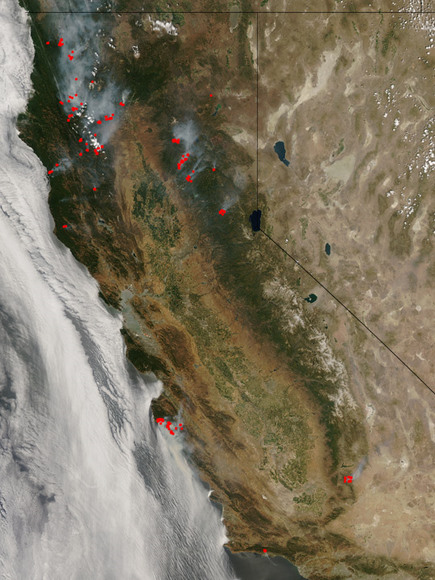
Thunderstorms in California brought lightning but little rain, starting several wildfires. This natural-color image was captured by MODIS on July 2, 2008, and it shows the location of actively burning fires marked in red. The highest concentration of fires is in Northern California, where reportedly 68 uncontained large fires were burning as of July 3. Meanwhile, Southern California was battling the state’s two largest blazes, shown in the lower half of this image.
These false-color images of the Santa Lucia Range Mountains near Big Sur, California, was captured by Advanced Spaceborne Thermal Emission and Reflection Radiometer (ASTER) on NASA’s Terra satellite on June 29, 2008. Vegetation is red, naturally bare ground is tan, burned ground is charcoal colored, and smoke is light blue. Clouds over the Pacific Ocean to the southwest are bright bluish white. Over 120,000 acres have been burned by the two large wildfires in this area.
With extremely hot weather conditions in Europe, Norway experienced its biggest forest fire in the last half century in June. ESA’s Envisat satellite images were used in the fire’s aftermath to get an overview of the damaged area for authorities and insurance companies. The Envisat Advanced Synthetic Aperture Radar (ASAR) image shows the burned area as a red cluster in the image center.
The fires (red dots) visible along the shoreline of Russia’s Khabarovsk Province at the upper left of this image are only a few of the forest fires responsible for the river of smoke spreading eastward over the Sea of Okhotsk and the Kamchatka Peninsula on July 2, 2008. This natural-color image of the area was captured by MODIS on NASA’s Aqua satellite. Like this image, many images area developed daily from orbiting satellites to to provide up-to-date satellite images of the Earth’s landmasses in near real time. The MODIS Rapid Response Team provides these images, many times with a few hours of being collected. This system is valuable resource for the international fire monitoring community, who use the images to track fires.
News sources: NASA’s Earth Observatory Natural Hazards site, ESA’s Observing the Earth site
The journey to Mars will subject astronauts to extended periods of exposure to radiation during…
Anthropogenic climate change is creating a vicious circle where rising temperatures are causing glaciers to…
Satellites often face a disappointing end: despite having fully working systems, they are often de-orbited…
Astronomers have known for some time that nearby supernovae have had a profound effect on…
How can we explore Saturn’s moon, Enceladus, to include its surface and subsurface ocean, with…
Have you ever wondered how astronomers manage to map out the Milky Way when it's…