An Ancient Martian Lake Was Larger Than Any Lake on Earth

The ESA’s Mars Express orbiter captured an image of the remains of a vast ancient lake on Mars. The remnant lake bed has been weathered and altered by the passing of billions of years. In the planet’s distant past, scientists say, it held enough water to fill Earth’s Caspian Sea almost three times over.

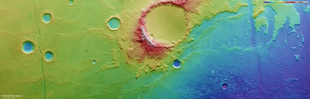
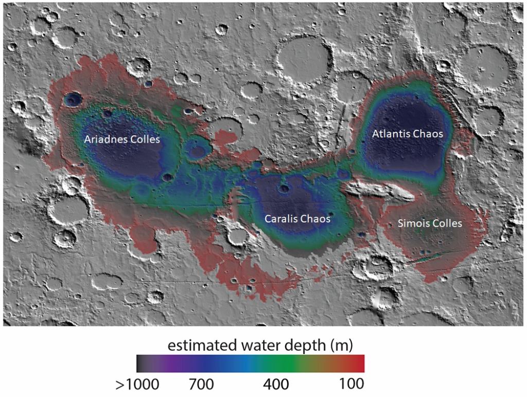
The leading image shows a region on Mars called Caralis Chaos.

At first glance, it just looks like a vague outline of a depression scrambled and scarred by time, with Mars’ ubiquitous impact craters sprinkled throughout the image. But for scientists who study planetary surface features, the image is rife with clues—clues that connect it to Mars’ warm and watery ancient past and to the ensuing episodes of change the planet underwent.

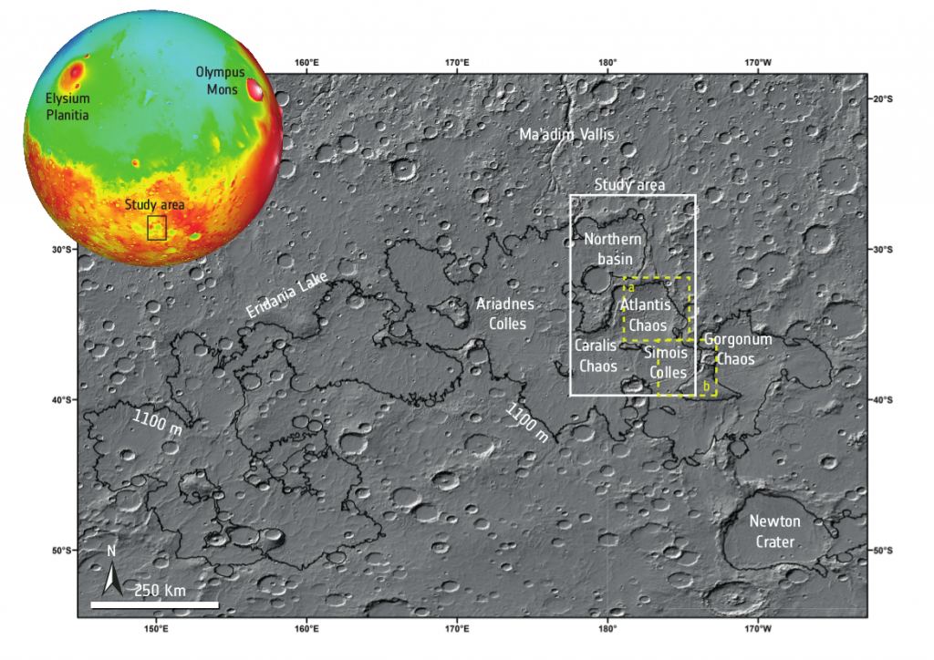
The following topographical map brings clarity.

Red is high elevation, and blue is low elevation. The lakebed boundaries curve up and away from the bottom centre of the frame towards the top right, skirting around the large central crater. This is one of several lakebeds in the region that were once joined into one vast lake named Lake Eridania. Image Credit: ESA/DLR/FU Berlin. Licence: CC BY-SA 3.0 IGO or ESA Standard Licence

The ancient lakebed consists of several basins surrounding and including the Caralis Chaos region. In the distant past, they were all joined into one big lake named Lake Eridania. It had a surface area of about 1.1 million square km. The largest non-ocean body of water on Earth is the Caspian Sea, with a surface area of 389,000 km.

This image puts the Caralis Chaos region into context. It's from a 2015 paper that focused on two parts of the Eridania Lake system: Atlantis Chaos and Simois Colles. Image Credit: Adeli et al. 2015.
This image puts the Caralis Chaos region into context. It’s from a 2015 paper that focused on two parts of the Eridania Lake system: Atlantis Chaos and Simois Colles. Image Credit: Adeli et al. 2015.

Liquid water was likely abundant on early Mars between about 4.1 and 3 billion years ago during the Noachian and Hesperian Periods. Mars may have even hosted a massive ocean that covered about one-third of its surface. Eridania Lake was likely a single lake until the late Noachian when Mars gradually lost its water. During that period, the lake was fragmented into multiple smaller lakes.

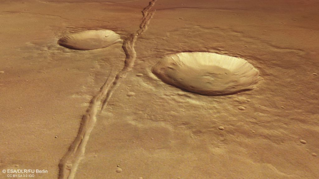
The ancient lakebed is now punctuated with mounds. Scientists think Mars’ dusty winds initially formed the mounds. Later, they were covered by water, then the water disappeared, and they were exposed to the wind again.

This perspective view shows the mounds on the floor of ancient Lake Eridani. Image Credit: ESA/DLR/FU CC BY-SA 3.0 IGO

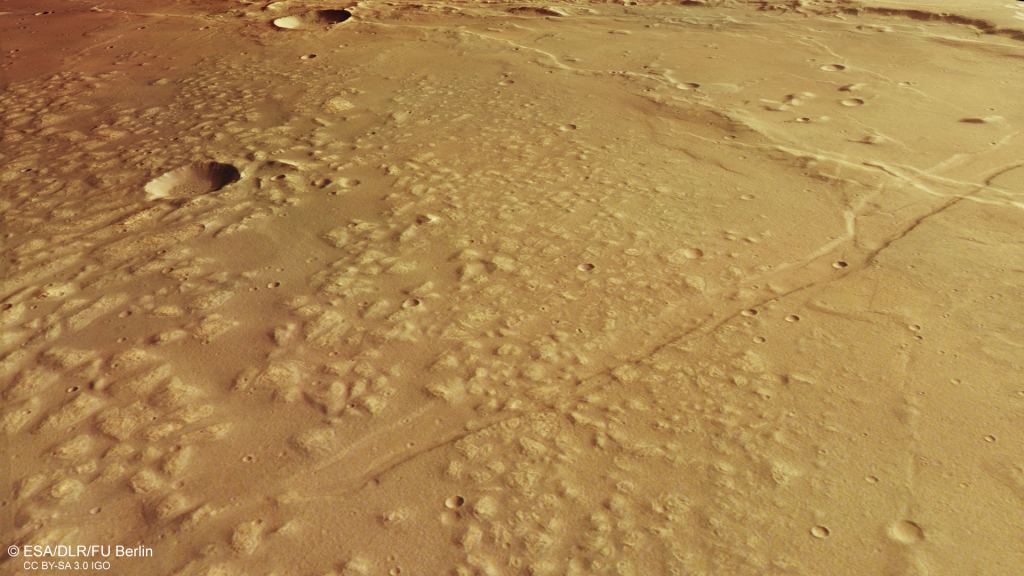
The floors of all of the basins that comprised Eridania Lake are covered by light-toned materials containing Fe/Mg-phyllosilicates. The region also has chloride, indicating that a playa region once existed here as the water receded. Some of the geological evidence in the region suggests that some surface water may have survived until long after the Noachian.
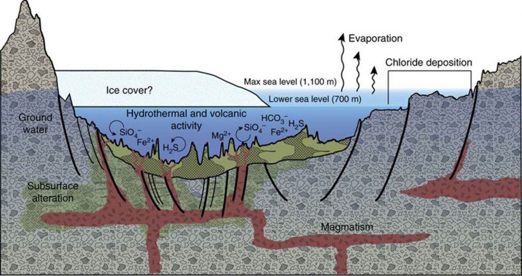
This diagram shows how volcanic activity may have caused the deposition of minerals on the floor of Lake Eridania. Chlorides were deposited along the shoreline by evaporation. Image Credit: By Jim Secosky chose this image NASA - https://www.jpl.nasa.gov/spaceimages/details.php?id=PIA22060, Public Domain, https://commons.wikimedia.org/w/index.php?curid=63303061
This diagram shows how volcanic activity may have caused the deposition of minerals on the floor of Lake Eridania. Chlorides were deposited along the shoreline by evaporation. Image Credit: By Jim Secosky chose this image NASA – https://www.jpl.nasa.gov/spaceimages/details.php?id=PIA22060, Public Domain, https://commons.wikimedia.org/w/index.php?curid=63303061

There’s also evidence of volcanic activity. Two large faults called fossae run through the region. Collectively, they’re known as Sirenum Fossae.

This image shows the extent and depth of ancient Lake Eridania. It also shows Sirenum Fossae, two large faults in the Martian surface. Image Credit: By Jim Secosky modified NASA image - https://photojournal.jpl.nasa.gov/figures/PIA22059_fig1.jpg, Public Domain, https://commons.wikimedia.org/w/index.php?curid=63330708
This image shows the extent and depth of ancient Lake Eridania. It also shows Sirenum Fossae, two large faults in the Martian surface. Image Credit: By Jim Secosky modified NASA image – https://photojournal.jpl.nasa.gov/figures/PIA22059_fig1.jpg, Public Domain, https://commons.wikimedia.org/w/index.php?curid=63330708

The region between the two faults is called a graben, a depressed portion of the crust. Sirenum Fossae was formed as Mars’ Tharsis region, a vast volcanic plateau that’s home to Olympus Mons and Tharsis Montes, rose up and put enormous pressure on the crust.

This is a perspective view of one of the Sirenum Fossae fault lines. Image Credit: ESA/DLR/FU CC BY-SA 3.0 IGO

These images all come from the ESA’s Mars Express Orbiter. It has been orbiting Mars since 2004, mapping its surface and minerals and studying the planet’s interior, subsurface, and atmosphere. It has been in orbit for more than 20 years. The ESA has extended its mission until at least the end of 2026 and has given it a provisional extension until 2028.