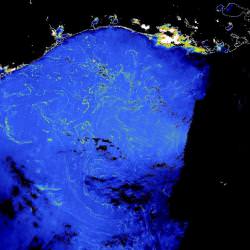
This strange looking photograph is actually the Gulf of Mexico, seen from space by ESA’s Envisat Earth imaging satellite. Specifically, the spacecraft has picked up huge lines of Sargassam seaweed floating in the warm waters off the coast of the US.
To make this observation, Envisat used the Medium Resolution Imaging Spectrometer (MERIS), which has the ability to see objects with large quantities of chlorophyll – in this case, seaweed. Since marine plants absorb half of the carbon dioxide emitted into the atmosphere, being able to track the density of marine vegetation is very important for climate research.
By using a new processing algorithm, researchers are now working to calculate global estimates of Sargassum biomass, to help keep track of its contribution to ocean productivity. This will also give them the ability to spot any changes in biomass, and better fine tune climate models.
Original Source: ESA News Release

