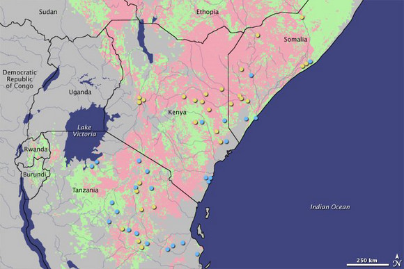
Responding to a deadly 1997 outbreak of the mosquito-borne disease Rift Valley fever, researchers had developed a “risk map,” pictured above, using NASA and National Oceanic and Atmospheric Administration measurements of sea surface temperatures, precipitation, and vegetation cover. As reported in a recent NASA-led study, the map gave public health officials in East Africa up to six weeks of warning for the 2006-2007 outbreak of the deadly Rift Valley fever in northeast Africa — enough time to lessen human impact.
On the map above, pink areas depict increased disease risk, while pale green areas reflect normal risk. Yellow dots represent reported Rift Valley fever cases in high-risk areas, while blue dots represent occurrences in non-risk areas. The researchers have detailed the map’s effectiveness in the Proceedings of the National Academy of Sciences.

During an intense El Niño event in 1997, the largest known outbreak of Rift Valley fever spread across the Horn of Africa. About 90,000 people were infected with the virus, which is carried by mosquitoes and transmitted to humans by mosquito bites or through contact with infected livestock. That outbreak prompted the formation of a working group — funded by the U.S. Department of Defense Global Emerging Infections Surveillance and Response System — to try to predict future outbreaks.
The working group didn’t start from scratch. The link between the mosquito life cycle and vegetation growth was first described in a 1987 Science paper by co-authors Kenneth Linthicum of the U.S. Department of Agriculture and Compton Tucker of NASA’s Goddard Space Flight Center. Later, a 1999 Science paper described a link between Rift Valley fever and the El Niño-Southern Oscillation, a cyclical, global phenomenon of sea surface temperature changes that can contribute to extreme climate events around the world.
Building on that research, Assaf Anyamba of NASA Goddard and the University of Maryland, and his colleagues, set out to predict when conditions were ripe for excessive rainfall — and thus an outbreak. They started by examining satellite measurements of sea surface temperatures. One of the first indicators that El Niño will boost rainfall is a rise in the surface temperature of the eastern equatorial Pacific Ocean and the western equatorial Indian Ocean. Perhaps the most telling clue is a measure of the mosquito habitat itself. The researchers used a satellite-derived vegetation data set that measures the landscape’s “greenness.” Greener regions have more than the average amount of vegetation, which means more water and more potential habitat for infected mosquitoes. The resulting risk map for Rift Valley fever, showing areas of anomalous rainfall and vegetation growth over a three-month period, is updated and issued monthly as a means to guide ground-based mosquito and virus surveillance.
As early as September 2006, the monthly advisory from Anyamba and colleagues indicated an elevated risk of Rift Valley fever activity in East Africa. By November, Kenya’s government had begun collaborating with non-governmental organizations to implement disease mitigation measures—restricting animal movement, distributing mosquito bed nets, informing the public, and enacting programs to control mosquitoes and vaccinate animals. Between two and six weeks later—depending on the location—the disease was detected in humans.
After the 2006-2007 outbreak, Anyamba and colleagues assessed the effectiveness of the warning maps. They compared locations that had been identified as “at risk” with the locations where Rift Valley fever was reported. Of the 1,088 cases reported in Kenya, Somalia, and Tanzania, 64 percent fell within areas delineated on the risk map. The other 36 percent of cases did not occur within “at risk” areas, but none were more than 30 miles away, leading the researchers believe that they had identified most of the initial infection sites.
The potential for mapping the risk of disease outbreaks is not limited to Africa. Previous research has shown that risk maps are possible whenever the abundance of a virus can be linked to extremes in climate conditions. Chikungunya in east Africa and Hantavirus and West Nile virus in the United States, for example, have been linked to conditions of rainfall extremes.
“We are coming up on almost 30 years of vegetation data from satellites, which provides us with a good basis for predicting,” said Linthicum, co-author on the 1987 paper, upon his return from a Rift Valley fever workshop in Cairo, Egypt last month. “At this meeting, it was clear that using this tool as a basis for predictions has become accepted as the norm.”
Sources: NASA and the Proceedings of the National Academy of Sciences


I know that somehow, some way, this will be touted as just another result of man-made “climate change”, whereby the entire Gaian ecosystem is about to collapse for eternity unless we draw lots to see which 90% of the human population will have to commit hari-kiri to reduce the CO2 we produce by breathing, as we hand absolute power to Algore and James Hansen.
Brought to you by the same folks who will also scream that the sky is falling if we actually let these regions use the best (and proven safe) method of controlling mosquito populations – DDT. The blood of tens of millions of people who have died from malaria is already on the hands of these fanatics, who tell us only they know how to save us from something they can’t even really prove is actually happening.
I’ve read books and articles about Mt. kilimanjaro,accountingly,there was periods when the mountain lost it’s mantle of glaciers several times in the last few thousand years, the last about about the same time NW Europe became much warmer, and the local peoples of that time did not begun to look back up to Mt Kilimanjaro as the year-roung lasting wonder until the climate cooled again.
The people who stopped the use of DDT in Africa really don’t care as long as they don’t live there.Since the banning of DDT, there are areas now considered TOO Dangerous to live in due to other deadly diseases spread by misquitos. This exodus from large former productive areas in recent times is not spread by the so-called ‘mass media’ and DDT opponents. You will have to hunt for the findings in articles, acturally local Newspapers in Africa and other articles from Africa itself, and these reports quite graphically explains about the serious exodus from the dangerous areas.The climate, geography, geology of Africa is very unique from the other continents. What may work or be bad for the other continents does not hold true for much of Africa. I’ve stated many times in other feeds, 98% of our climate is controlled by the Sun, 2% from Earth itself, and .015 by humans. The whole purpose of this pro-warming deal is Empire Building for the proponents of Global Warming, they want to build a much larger bureaucracy, a bureaucracy needs funds, funds equals power, power demands more funds and so on. I worked for the State of California 2 years ago at age 55, and know about how governments operate,and I was happy I had a boss who also came from the outside to modernize the sorry data processing they had in 1982 and got rid of the dogs who can’t learn new tricks. However, this is a United Nations affair, years ago, one of my close cousins worked for the United Nations until they decided to move back to California. My cousin said in 1980, there was ‘administrators’ or asst.admins or assistants to so and so who made >200k a year, most of these people were not seen at the office for months, all they need to say is they were doing ‘field work’ – some who were around had 2- 2 hour breaks and a 4 hour lunch,lol. I was kinda leary at first of having Reagon for president, but he had the b__s to tell the UN the US will no longer fund the United Nations unless they get their s___ together, and even then, will no longer give more than necessary.
The 10s’ of millions you talk about is true, over 100M has left or leaving the dangerous regions as they are now the domain of the misquitos. It is too bad there are such corrupt governments in Africa as most of the countries are resouce rich, in many respects, at the top of the list of some resources.
addendum, I should have said i worked for the State of California 24 years and retires in 2006 at age 55, otherwise, I stand by my conclusions.