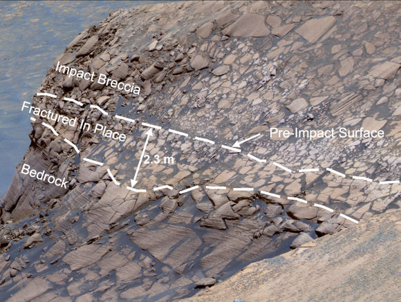
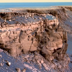
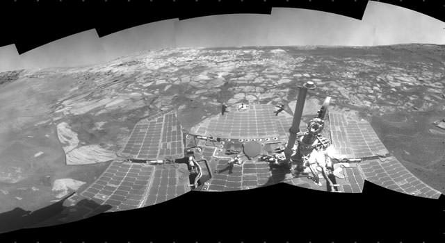
A sizable collaboration of researchers has unveiled an enormous set of data from NASA’s Opportunity rover today — data that testify to the rover’s lucky longevity, and paint a picture of climate events that have shaped Victoria Crater, shown in this NASA/JPL-Caltech image.
The climate history is vast and compelling, including dramatic floods and terrain-shaping winds spanning billions of years. The data appear in today’s issue of the journal Science.
Because of the Mars rovers’ ability to move from place to place and also because of their unexpected long lives, the mission scientists have been able to study Mars in situ in a way they weren’t anticipating.
“There’s no way Spirit and Opportunity could have made all of these discoveries without the longevity that they’ve had,” said principal investigator Steve Squyres, of Cornell University in Ithaca, N.Y. “Mars has been good to us, but more than anything else, I think their longevity is testimony to the excellence of the work that was done by the team that built these vehicles so many years ago.”

The Opportunity rover has been able to study in detail three different craters located over three miles apart. Data and images from the rover show similar patterns in sedimentary rocks in each crater, patterns that could only have been laid down by ancient water flow. According to Squyres and his team, this discovery means that water once covered the entire area and helped shape that region of the planet long ago.
The rover revealed that water repeatedly came and left billions of years ago. Wind persisted much longer, heaping sand into dunes between ancient water episodes. These activities still shape the landscape today. At Victoria, steep cliffs and gentler alcoves alternate around the edge of a bowl about 0.8 kilometers (half a mile) in diameter. The scalloped edge and other features indicate the crater once was smaller than it is today, but wind erosion has widened it gradually.

“What drew us to Victoria Crater is the thick cross-section of rock layers exposed there,” Squyres said. “The impact that excavated the crater millions of years ago provided a golden opportunity, and the durability of the rover enabled us to take advantage of it.”
Imaging the crater’s rim and interior, Opportunity inspected layers in the cliffs around the crater, including layered stacks more than 10 meters (30 feet) thick. Distinctive patterns indicate the rocks formed from shifting dunes that later hardened into sandstone, according to Squyres and 33 co-authors.
Instruments on the rover’s arm studied the composition and detailed texture of rocks just outside the crater and exposed layers in one alcove called “Duck Bay.” Rocks found beside the crater include pieces of a meteorite, which may have been part of the impacting space rock that made the crater.
Inside Duck Bay, the rover found that the lower layers showed less sulfur and iron, more aluminum and silicon. This composition matches patterns Opportunity found earlier at the smaller Endurance Crater, about 6 kilometers (4 miles) away from Victoria, indicating the processes that varied the environmental conditions recorded in the rocks were regional, not just local.
Squyres said there were specific minerals and specific patterns in the geochemistry of the crater walls. In all three craters, Eagle, Endurance and Victoria, the round, iron-rich spherules — BB-like structures — which the scientists nicknamed “blueberries,” were found embedded in the rock. The scientists have concluded that these were created from mineral deposits emerging from a watery solution inside the rock.
Opportunity gained more than 30 meters (98 feet) of elevation travelling from Endurance to Victoria, and the amount of “blueberries” decreased with the elevation. But once the rover entered Victoria crater, which is about 75 meters (246 feet) deep — and 750 meters in diameter — the spherules reappeared in the soil.
The spherules in rocks deeper in the crater are larger than those in overlying layers, suggesting the action of groundwater was more intense at greater depth.
Opportunity’s first observations showed interaction of volcanic rock with acidic water to produce sulfate salts. Dry sand rich in these salts blew into dunes. Under the influence of water, the dunes hardened to sandstone. Further alteration by water produced the iron-rich spherules, mineral changes and angular pores left when crystals dissolved away.
A rock from space blasted a hole about 600 meters (2,000 feet) wide and 125 meters (400 feet) deep. Wind erosion chewed at the edges of the hole and partially refilled it, increasing the diameter by about 25 percent and reducing the depth by about 40 percent.
Since leaving Victoria Crater about eight months ago, Opportunity has been on its way to study a crater named Endeavour that is about 20 times bigger than Victoria. The rover has driven about one-fifth of what could be a 16-kilometer (10-mile) trek to this new destination.
Sources: NASA and an e-mail exchange with Steve Squyres.


What a rich variety of geology in just this small region on Mars. Kudos to Steve Squires and his team in piecing together this geologic panorama. Thanks, Nancy, for your personal work on presenting this fascinating overview of the geology being performed at this site 🙂
Can’t wait to see movie(s) made from the assemblage images! A virtual ‘Walk-about’ on Mars~
Ahem… assemblage OF images…..
from the article:
“… because of their unexpected long lives, the mission scientists have been able to study Mars in situ in a way they weren’t anticipating…”
– as david suzuki would affirm, when scientists have been let off of their leashes and allowed to mess around, it has in the past led to some of our greatest scientific discoveries.