[/caption]
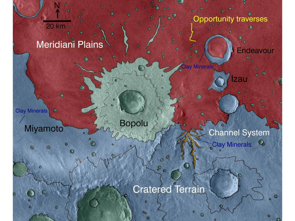
NASA is using its powerful science surveyor orbiting more than 241 kilometers above Mars to target the surface explorations of the long lived Opportunity rover to compelling science targets on the ground. Opportunity is currently on a long term trek to the giant crater named Endeavour, some 22 kilometers in diameter, which shows significant signatures of clays and water bearing sulfate minerals which formed in the presence of flowing liquid water billions of years ago.
An armada of orbiters and rovers from Earth are carrying out a coordinated attack plan to unlock the mysteries of the red planet, foremost being to determine whether life ever arose on Mars.
On Dec. 15 (Sol 2450), Opportunity arrived at Santa Maria crater which is just 6 km distant from the western rim of Endeavour. Over the past 2 years, the rover has traversed more than two thirds of the 19 km distance from Victoria crater -her last big target – to Endeavour.
High resolution spectral and imaging mappers aboard NASA’s Mars Reconnaissance Orbiter (MRO) are enabling researchers on the rover team to prioritize targets and strategically guide Opportunity to the most fruitful locations for scientific investigations.
The on board CRISM mapping spectrometer has detected clay minerals, or phyllosilicates, at multiple locations around Endeavour crater including the western rim closest to Opportunity. CRISM is the acronym for Compact Reconnaissance Imaging Spectrometer for Mars. Images from MRO’s HiRISE camera are utilized to scout out the safest and most efficient route. See maps above and below.
“This is the first time mineral detections from orbit are being used in tactical decisions about where to drive on Mars,” said Ray Arvidson of Washington University in St. Louis. Arvidson is the deputy principal investigator for the Spirit and Opportunity rovers and a co-investigator for CRISM.
Clay minerals are a very exciting scientific find because they can form in more neutral and much less acidic aqueous environments which are more conducive to the possibility for the formation of life. They have never before been studied up close by science instruments on a landed mission.
Opportunity may soon get a quick taste of water bearing sulfate minerals at Santa Maria because spectral data from CRISM suggest the presence of sulfate deposits at the southeast rim of the crater. Opportunity has previously investigated these sulfate minerals at other locations along her circuitous traverse route – but which she discovered without the help of orbital assets.
“We’ve just pulled up to the rim of Santa Maria, and the workload is very high,” Steve Squyres informed me. Squyres, of Cornell University, is the Principal Scientific Investigator for NASA’s Spirit and Opportunity Mars rovers.
Opportunity drove to within about 5 meters of the crater rim on Dec. 16 (Sol 2451). JPL Mars rover driver Scott Maxwell tweeted this message ; “Today’s NAVCAM mosaic of Santa Maria Crater. Woo-hoo! Glorious and beautiful!” and this twitpic
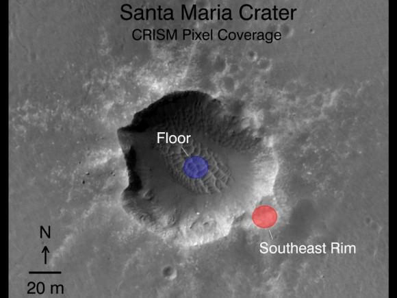
Opportunity just arrived at the western side of Santa Maria Crater, some 90 meters wide, on 15 December 2010. Researchers are using data collected by a powerful mineral mapping spectrometer (CRISM) aboard NASA’s Mars Reconnaissance Orbiter (MRO) to direct the route which Opportunity is traversing on Mars during the long term journey to Endeavour crater. Spectral observations recorded by CRISM indicates the presence of water-bearing sulfate minerals at the location shown by the red dot on the southeast rim crater whereas the crater floor at the blue dot does not. This image was taken by the the High Resolution Imaging Science Experiment (HiRISE) camera also on MRO. Credit: NASA/JPL-Caltech/Univ. of Arizona
The rover will conduct an extensive science campaign at Santa Maria by driving to different spots over the next several weeks and gathering data to compare observations on the ground to those from CRISM in orbit.
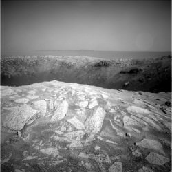
Santa Maria crater appears to be relatively fresh and steep walled and was likely created by a meteor strike only a few million years ago. Endeavour is an ancient crater with a discontinuous rim that is heavily eroded at many points. By exploring craters, scientists can look back in time and decipher earlier geologic periods in Mars history.
Scientists believe that the clay minerals stem from an earlier time period in Martian history and that the sulfate deposits formed later. Mars has experiences many episodes of wet environments at diverse locations in the past and climate-change cycles persist into the present era.
After the upcoming Solar Conjunction in February 2011, Opportunity will depart eastwards for the last leg of the long march to Endeavour. She heads for a rim fragment dubbed Cape York which spectral data show is surrounded by exposures of water bearing minerals. Cape York is not yet visible in the long distance images because it lies to low. See maps below.
Thereafter, Opportunity alters direction and turns south towards her next goal –
Cape Tribulation – which is even more enticing to researchers because CRISM has detected exposures of the clay minerals formed in the milder environments more favorable to life. Cape Tribulation has been clearly visible in rover images already taken months ago in early 2010.
Opportunity could reach Endeavour sometime in 2011 if she can continue to survive the harsh environment of Mars and drive at her current accelerated pace. Opportunity arrived at Mars in January 2004 for a planned 90 day mission. The rover has far surpassed all expectations and will soon celebrate 7 earth years of continuous operations on the red planet. Virtually all the data from Spirit and Opportunity are relayed back to Earth via NASA’s Mars Odyssey orbiter.
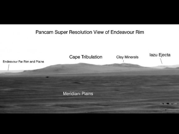
Opportunity used its panoramic camera in a super-resolution technique to record this view of the horizon on Sol 2298 (July 11, 2010) which shows the western rim of Endeavour Crater, including the highest ridge informally named “Cape Tribulation”. CRISM data revealed exposures of clay minerals at Cape Tribulation.
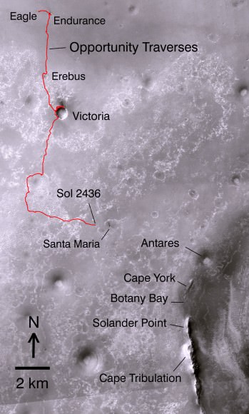
Opportunity’s Path on Mars Through Sol 2436
The red line shows where Opportunity has driven from the place where it landed in January 2004 — inside Eagle Crater, at the upper left end of the track — to where it reached on the 2,436th Martian day, or sol, of its work on Mars (Nov. 30, 2010). The map covers an area about 15 kilometers (9 miles) wide. North is at the top. Subsequent drives brought Opportunity to Santa Maria Crater, which is about 90 meters (295 feet) in diameter. After investigating Santa Maria the rover heads for Endeavour Crater. The western edge of 22-kilometer-wide (14-mile-wide) Endeavour is in the lower right corner of this map. Some sections of the discontinuous raised rim and nearby features are indicated with informal names on the map: rim segments “Cape York” and “Solander Point”; a low area between them called “Botany Bay”; “Antares” crater, which formed on sedimentary rocks where the rim was eroded down; and rim fragment “Cape Tribulation,” where orbital observations have detected clay minerals. The base map is a mosaic of images from the Context Camera on NASA’s Mars Reconnaissance Orbiter.

Why does the description leave me feeling like S&O went in blind? (Yes, landing ellipses and all that. Still…) Anyway, I’m definitely happy with where Opportunity is headed.
To apply something I learned from a Mars crater paper, the central cone upthrust from a high speed impactor comes from something like ~ 1/10 of the crater diameter. That makes sense I think, since if it is a hypervelocity impactor is it claimed in my text books that the impactor is ~ 1/20 the crater diameter. It looks all shock impact energy driven.
Now there doesn’t look to be an upthrust cone in the center of Endeavour. But I can hypothesize that the rim material comes from upthrust. The exposed rim clay materials test that nicely, so I’ll accept that for the time being. Then it would be reasonable to assume they too would come from such depths, also consistent with the apparent energy scaling.
In this case the clays can come from layers ~ 2 km down, or much later than the (IIRC) carbonate upthrust I read on coming from ~ 6 km down. (A ~ 60 km diameter crater, with central cone.) The later mineral indicated seas and later hydrothermal activity. Which clicks nicely with the presence of one of the major methane sources nearby, apparently carbonates, CO2, pressure, and water, makes for such production.
Hopefully the “near surface” clays indicate something about the extent in space and time of Mars hydrological cycle. If the current large methane release indicates major supplies of liquid water at depth, and the pressure isn’t prohibitive, they could be populated with bacteria.
[I dunno. IIRC the proposed Goldilocks zone for bacterial survival on Earth under the LHB is ~ 1 km, and with Mars gravity at ~ 0.4 g it would scale to “only” ~ 2 km depth as for pressure alone. But it could have been the crust temperature raise with depth that set the limit. I need to go study that now. :-o]
It would be good to know if these putative populations, or their fossil traits, are accessible at lesser depths and in more extensive samples.
Fabulous article on Mars and Opportunity and the map is superb !
I do have some questions tho:
In Opportunity’s Santa Maria crater rim photo, the ‘blueberries’ are very noticible, and right on top of rocks right at the rim. They must have been distributed there after the crater was formed. How ?
They would be eroded out for sure, and possibly scattered by impacts now and then. (Unless the winds moves them too, dunno where the cut off is for wind transport on Mars.)
Yeah, I mean, I always thought blueberries are pretty solid but looking, for example, at rover tracks here:
http://marsrover.nasa.gov/gallery/all/1/n/2451/1N345782322EFFB0IEP1905R0M1.JPG
makes me wonder as they appear ‘smashed’ by rover’s wheels.
Good thought, good catch, but I can’t tell if they are smashed.
AFAIU blueberries appear as pure hematite, an iron oxide. I believe dust of that oxide “cement” together, and can do so rather loosely.
Here in Sweden they can be found in the many marshes that former post ice age lakes now forms, iron leech out of the rocks and can form oily looking skins on them and deposit as sometimes berry formed hematite associated with limonite (an iron oxide mineral).
I believe I have seen such, unless I confuse them with man made iron pellet (perhaps likely). They were not particularly hard – but the ref I found on “bog ore” found them hard.
So I dunno about the density of them.
I should also mention, as a historical curiosity, that “bog ore” was of great importance during the early iron and merchant ages of Sweden. It made it easier to come by the element and get to purified melts, especially in parts where there were no known mines.
In the Opportunity Navcam camera view of Santa Maria Crater, what is the object in the sky to the right? Judging from the lighting, the sun is to the far right in the photo (the south) and we’re looking west to east. Is that one of Mar’s moons?
I think it may be a lighting flare in the camera lens. There also looks to be some ‘hot pixels’ as well
Surely lots of blueberries there 🙂
Is Oppy going to drive by itself during solar conjunction or is it going to sleep at that time?
Imagine what all those little blueberries rolling around the surface during a supercell dust devil or planet wide dust storm might do? ………… Set in motion, how fast might a typical blueberry travel? How much does a typical blueberry weigh, on Mars? or Earth? Exposure might be like getting hit by several B-B Gatling guns at once?
Instead of sending men back to the moon and building up a program why not send these rovers to the moon along with these lunar probes that every country is sending? They seem to work out really well.
Why not send rovers to somewhere really interesting instead, say, Io?