Image credit: NASA
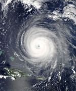
NASA’s Aqua satellite took this overhead view of Hurricane Isabel on September 14, 2003 while it was 650 km north of Puerto Rico. The image was acquired using Aqua’s Moderate Resolution Imaging Spectroradiometer (MODIS). Isabel is currently a category 4 hurricane, with winds as high as 220 km/h – this is about 15 km/h slower than they were on the weekend. Residents, businesses, and even the military are taking precautions in case Isabel doesn’t lose strength and hits the coast of the North America.
The Moderate Resolution Imaging Spectroradiometer (MODIS) instrument onboard NASA’s Aqua satellite captured this image of Hurricane Isabel September 14, 2003. In this image Hurricane Isabel is approximately 400 mi north of Puerto Rico.
*** Note: We’re tracking more satellite photos of the hurricane in the Universe Today forums. Click here to see the updates each day.

i reallt want to jnow what will happen to earth if we hit son? what is the temp. of the son./
yes same here i always wonder when is earth is going to be so close to the sun and what will sun do to the earth.??/