[/caption]
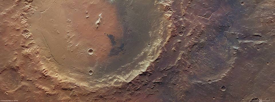
In the southern highlands of Mars, Eberswalde crater to be exact, ESA’s Mars Express exploration has pinpointed an area which once held a lake. Although it may have been some 4 billion years ago, the geologic remains – called a delta – are still evident in the new images. This region of dark sediments are a shadowed reminder that Mars once had water.
Formed by an asteroid strike, Eberswalde crater has nearly eroded away with time. After it formed, it was partially obliterated by another impact which shaped 140 km diameter crater Holden. Although this second strike buried Eberswalde with ejecta, 115 square kilometers of delta area and feeder channels survived. These channels once were the arteries that pumped water along the surface to pool in the crater’s interior, forming a lake. As they carried water, they also carried sediments and – just as on Earth – left their mark. With time, the water dried up and even more sediments were carried along by the wind, exposing the area in vivid relief.
NASA’s Mars Global Surveyor spacecraft spied the delta in earlier missions, giving even further solidification that Mars was once a wet world. While Eberswalde crater and Holden crater were once a part of a list of possible landing sites for the Mars Science Laboratory, Gale crater was selected as the Curiosity’s landing site, given its high mineral and structural diversity related to water. But don’t count this wonderful, wet confession of a lake out forever. Thanks to high mineral diversity and suggestive structure, we’re sure to visit the delta of Eberswalde and Holden again, from orbit or with another landing mission.
Original Story Source: ESA News.


The Martian landscape is tremendously intriguing ..to say the least.
This opens up a whole nother window about planets that may of held life or has life on it at the moment somewhere in the universe.
Its fascinating that the dark sediments in the image coalesced into the ‘colony like’ formation of dark sand dunes in Holden crater. Which are also evident throughout mars where water may have pooled. Why is it that this dark sediment / material creates sand dunes, what keeps it separate from the more predominant minerals on the planet?
Studies abound regarding the shape of the dunes and how Martian winds form them but little is known regarding their composition. Volcanic Basalt with Sulphates are the best guesses I have read. We do know that they trap CO2 in some way leading to the seasonal dark blooms observed in the polar regions, but I cant find any explanation for what process would lead to this.
In these images its obvious that Water flows carried these minerals to their location where they coalesced into the sand dunes. But did the sand dunes appear while the water was present or did they form after the water dissipated. ? Geographically they appear wherever the hydrology of water flows would end, thus they are perfectly placed to ‘trap’ any water outflows.
I will ‘speculate’ that these dunes may be the best chance of finding Martian life if it ever existed, by citing their prevalence at the last places water would have remained and the dynamics of their composition. The dark surface traps heat and provides one of the most stable and sheltered natural formations we have observed on mars. The observed seasonal blooms could indicate the presence of biology that expels accumulated C02 during the Martian winter.
We have detected seasonal Methane releases on mars, the ONLY seasonal dynamic system we have observed are the sand dunes. I do wish more observations and study was directed towards this.
http://www.universetoday.com/74091/mars-methane-gets-even-more-mysterious/
Orphan alert! The ESA source text was considering the Curiosity mission. This article was not.