[/caption]
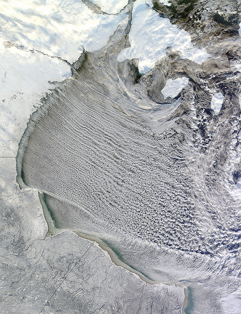
I love looking at unusual cloud formations, and these have to be some of the most intriguing. These long, horizontal rolls of clouds are called “cloud streets” and NASA’s Terra satellite had a “drive by” of these clouds, observing them over Hudson Bay, Canada on November 20, 2011 at 12:25 p.m. EST (17:25 UTC). These rows of clouds stretch from northwest to southeast over the Hudson Bay.
Cloud streets are long lines or bands of cumulus clouds that usually form within the lower one to three kilometers of the atmosphere, and come from eddies in the atmosphere.
According to NASA’s Earth Observatory and the Goddard Space Flight Center Flickr page, cloud streets form when cold air blows over warmer waters, while a warmer air layer—or temperature inversion—rests over top of both. The comparatively warm water of Hudson Bay gives up heat and moisture to the cold air mass above, and columns of heated air—thermals—naturally rise through the atmosphere. As they hit the temperature inversion like a lid, the air rolls over like the circulation in a pot of boiling water. The water in the warm air cools and condenses into flat-bottomed, fluffy-topped cumulus clouds that line up parallel to the wind.
Hudson Bay is a large body of saltwater located in northeastern Canada. Also in the image, are several snow-covered islands in Hudson Bay. The larger island to the north is South Hampton Island, and the smaller island east is Coats Island, and further east is Mansel Island.


The comparatively warm water of Hudson Bay gives up heat and moisture to the cold air mass above, and columns of heated air thermals naturally rise through the atmosphere.
AWESOME ! That looks just so cool ! Amazing !
Beautiful!
“Comparatively warm” is right. Hehe ain’t nothing just “warm” about Nunavut at any time of year!