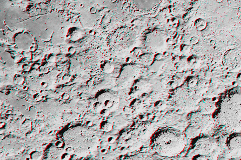
[/caption]
Love 3-D images? Interested in maps? Want to explore the Moon? Then a new Kickstarter project may be just what you are looking for. Jeffrey Ambroziak, creator of a specialized 3-D map projection method, will be producing what he calls the first true 3-D map of the Moon, and he is offering space enthusiasts the chance to get either digital or paper copies of the map, created from recently released data from the Lunar Reconnaissance Orbiter. Interest in the project has skyrocketed, and while the goal of $5,000 has already been reached by more than double that amount, Ambroziak is now thinking of what more he can offer to backers of his PopView 3D Moon Map.
“We’re at a place now where you can do some interesting research on your own, and it doesn’t necessarily require a large institution,” Ambroziak said by phone. “I love the idea of using Kickstarter to give interested and passionate space aficionados the opportunity to work with us.”
The maps will include not only 3-D views of the Moon’s surface, but on the “front side” will be “National Geographic-style” graphics and information.
Ambroziak said the backers who fund his project will be instrumental choosing the mapping locations and the information that is included.
“This will be very a very collaborative effort to pick the things we will put on the front of the map and the areas that we actually map in 3-D,” he told Universe Today. “As the Kickstarter project description makes clear, we are going to leverage the knowledge of all involved to produce a map that is as informative as it is innovative while letting everyone experience our excitement as the project takes shape. And in the end, everyone gets a copy of the map!”
Ambroziak added, “In the current age with NASA’s budget cuts and the space agency looking towards private enterprise more, there is now a place for interested people to create very interesting and useful space products. We spend billions of dollars to gather incredibly beautiful data of the Moon and Mars and much of it just sits around. We are looking to do our part to bring this data to life, and I’m proof of that you don’t have to sit around and wait for NASA to make an image from LROC data. We don’t have to wait anymore, we can do it ourselves.”
Ambroziak has been overwhelmed that his project is so popular. “I love the idea of the feedback that I’m getting already from people who are so excited about this project,” he said. Most gratifying was a top level pledge of $1,200 from former astronaut and shuttle pilot William Readdy, pledged $1200 to the project who wished Ambroziak “godspeed” in the effort. “It’s pretty neat when astronauts see the importance of what is being attempted,” Ambroziak said.
His patented Ambroziak Infinite Perspective Projection (AIPP) is a map projection method used for three-dimensional stereo visualization of geographic data, which allows viewers to see precise representation of data in 3-D, no matter what angle or distance the image is being viewed. He detailed the method in his book, Infinite Perspectives: Two Thousand Years of Three-Dimensional Mapmaking, (Princeton Architectural Press, 1999) and has previously created 3-D maps of Antarctica and Mars, which have been displayed at museums such as the Peabody Museum of Natural History.
I asked Ambroziak how far along he was with the project.
“I have downloaded all of the LROC imagery and digital elevation information,” he said. “I have further processed the image data to stretch out the contrast, computed shadows from the digital elevation model, and mixed the computed shadows back into the imagery to improve appearances. AIPP is then applied as desired to create 3D images. Specifically, imagery and digital elevation data is combined in accordance with a few chosen AIPP parameters (vertical exaggeration, view plane elevation, etc.) to produce the AIPP map.”
But that is only the technical part of the project, as the “front side” of the maps will be more artistic.
“I will be able to poll the backers for their preferred area of interest,” he said. “In short, you back the project, you have a say in the mapping of the Moon! Ultimately, I would like to perform a systematic mapping of the entire surface of the Moon in accordance with the USGS quad-map nomenclature and format. This is just the first step. This is Kickstarter – not start and then end.”
Check out the Kickstarter page for the “prizes” or incentives are for the various levels of funding. They range from getting a digital copy emailed to you, to complete posters, to an invitation to dinner for you and a guest with the Ambroziak, with food and drinks on him.


Just passing by, then, I found this site! The picture is really good and I guess that is the most recent picture from Moon Facts.
Facts About Earth
Numerous post with onle-liners that have absolutely no content: SPAM ALERT!
whoa whoa whoa whoa
this pic is awesome O_O
Much thanks Hoborg.