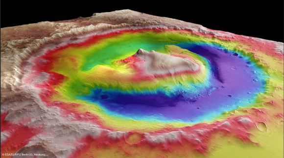
Here’s an intriguing look at Gale Crater, the landing spot for the Mars Science Laboratory’s Curiosity rover. This image was taken by the High Resolution Stereo Camera (HRSC) on the Mars Express spacecraft and it is color-coded based on variations in terrain. The lower elevation, shown in purple is the target landing area, but scientists and engineers want to get the rover as close as they can to the big mountain, Mount Sharp — which rises 5.5 km above the crater floor — where all the interesting geologic features are.
Orbiting spacecraft have already identified minerals and clays there that suggest water may have once filled the area, and as Curiosity slowly makes its ascent of the mountain region, it will analyze samples of these materials with its onboard laboratory in search of the building blocks of life.
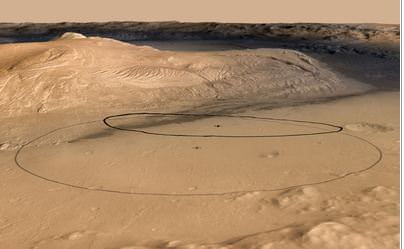
The crater itself is 154 km wide, and Curiosity is aiming for a target landing ellipse that is 20 x 7 km. Initially, the rover had a target landing ellipse of 20 X 25 km, but by combining elevation data from the HRSC on Mars Express, image data from the Context Camera on NASA’s Mars Reconnaissance Orbiter, and color information from Viking Orbiter imagery, the target ellipse was adjusted to a smaller area.
Mars Express will be an integral part of Curiosity’s landing, providing tracking and communication data for the spacecraft.
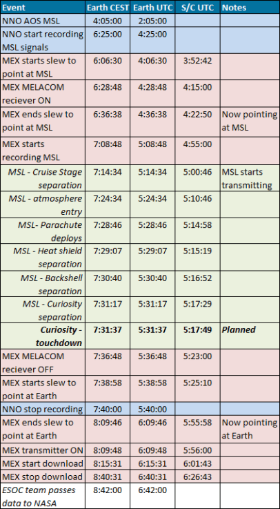
The highlight of ESA’s support for NASA’s Curiosity landing happens at 06:29 on Monday, 6 August, when the Mars Express Lander Communication (MELACOM) system is switched on.
Recording of the radio signals transmitted by the Mars Science Laboratory (MSL) is planned to begin at 07:09 and end at 07:37 (all times shown as ground event time in CEST).
ESA’s ground tracking station in New Norcia, Australia, will also listen and record signals from the NASA mission at the same time.
At 08:15, Mars Express will contact Earth via ESA’s 35 m deep space station at New Norcia, and begin transmitting the recorded information, which should take about 11 minutes to download; signals will take nearly 14 minutes to cover the 248 million km distance to Earth.
The transfer will be complete by about 08:26; the data will be transferred in real time to ESOC, and made immediately available to NASA’s MSL mission team at the Jet Propulsion Lab in California.
Here’s a graph from ESA of the timeline:
source: ESA


For those with a lot of tense about the 7 minutes of terror