Here’s a complete animation of Hurricane Sandy from October 23-31, as seen by GOES-13, a geosynchronous satellite that is in orbit nearly 36,000 km (23,000 miles) above Earth. This huge storm was costly in terms of death and destruction. The death toll currently stands at 160 (88 in the U.S., 54 in Haiti, 11 in Cuba), with damage estimates ranging from $10 – $55 billion.
Below is a timelapse animation which shows the full hemisphere view from GOES-13, showing the development of Hurricane Sandy as it begins over Central America and begins its path up through the Caribbean and the east coast of the U.S.
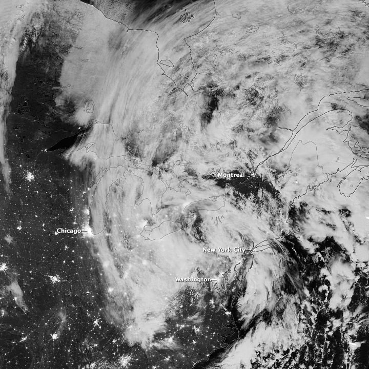
The Visible Infrared Imaging Radiometer Suite (VIIRS) on the Suomi NPP satellite acquired this image of the storm around 3:13 a.m. Eastern Daylight Time (7:13 Universal Time) on October 31. Credit: NASA/NOAA
This image from the Suomi NPP satellite shows remnants of Hurricane Sandy as it moved inland in the early morning hours of October 31, 2012. As the center of the system passed Pennsylvania, its maximum sustained winds were 40 miles (64 kilometers) per hour. This image is from the “day-night band” on VIIRS, which detects light wavelengths from green to near-infrared. The Moon lit the tops of the clouds.
Sandy’s clouds stretched from Hudson Bay to Chicago and Washington. Clusters of lights gave away the locations of some cities throughout the region; but along the East Coast, clouds mostly obscured the lights, many of which were blacked out due to the storm. On October 31, the Wall Street Journal reported that several million customers in multiple states were without electricity.
You can see more satellite images of Sandy’s traverse at the NASA Earth Observatory website.


Time for a proofread? This huge satellite didn’t cause death and destruction, really
I have read news articles claiming that “nobody predicted” this historic tidal storm surge.
Perhaps they should check into the episode of the Weather Channel’s TV program
“It Can Happen Here”, entitled “What if a hurricane struck NYC?”.
In that program, produced several years ago (which admittedly describes the effects of a much stronger hurricane in a somewhat sensationalistic fashion), geology Professor David Coch (of New York City’s Queens College) very accurately and precisely predicted the devastating consequences to NYC that would be produced by a hurricane taking the track that Sandy took,…. especially with regard to potential tidal flooding.
In that program, Professor Koch outlines the fact that we have an “L” shaped coastline, with the corner of the “L” being NY Harbor. Therefore, any hurricane coming inland into the New Jersey coast to our south, as Sandy did, would cause strong winds and waves to come in from the southeast off the ocean. This would push enormous amounts of water into the corner of the “L” (that is, into New York harbor), as well as -at the same time- pushing sea water surges down Long Island Sound into the East River. All of which would mean that the sea water would have no place to go except the streets, the subways, and the tunnels of low lying areas of NYC, causing devastating tidal flooding.
Which is exactly what happened.
IF Mayor Bloomberg had understood and heeded the realities of this kind of storm track and scenario (which was very accurately predicted by many forecasters days in advance) —instead of relying on the erroneous and reckless decision of the Weather Bureau NOT to issue any hurricane warnings for this so-called “hybrid: storm (with 94 mile winds!)
….THEN….
we would have had a much earlier and a much more orderly evacuation – instead of a last minute rush to action by the Mayor and the City on Sunday (the day before the storm).
We of course need to harden our infrastructure. But …both the Weather Bureau and the Mayor’s advisors absolutely also need to get their act together for future situations like this, as they begin to occur more and more frequently….
As possible supplement to an eye-opening comment, read this yesterday in the Daily Mail:
“Will New York build $6 BILLION sea barriers to shield itself from another Superstorm Sandy?”
http://www.dailymail.co.uk/news
Hey guys, I just thought that I’d come on over and share some images I have captured of the experience we went through here on Staten Island, NY. My family and I are okay and we’re working on getting things back to normal. Many have lost everything and have nothing left. If anyone have and news on resources please feel free on leaving a comment on any two of the links I am providing. All comments and encouragements are grateful!
(Day 1) Hurricane Sandy Hits Staten Island, NY.- Major Damages – By Jay Rodriguez – http://goo.gl/9VplQ
(Day 2) Hurricane Sandy on Staten Island, NY – Day 2 – By Jay Rodriguez – NY & NJ – http://goo.gl/vCEGv