[/caption]
When was the Sun discovered? Obviously the Sun is such an important feature in our lives, and the absolute necessity to all life on Earth. It’s kind of impossible to say when the Sun was discovered, since the first life forms on Earth probably relied on its energy. Humans have been well aware of the Sun for tens of thousands of years, and before modern astronomy had no idea what it was.
So perhaps a better question might be, when did we realize that the Sun is a star?
The Sun is incredibly important to our lives. When the Sun is in the sky, we have day. And when the Sun is below the horizon, we have night. Our biological clocks are programmed on it, and we life our lives by this routine. Ancient peoples thought the Sun was some kind of deity, and many civilizations – like the Inca in South America – worshipped it.
The Greek philosopher Anaxagoras first proposed that the Sun was a burning ball of fire, larger than a Greek Island, and not the chariot of a god. And other astronomers were able to calculate the distance to the Sun with surprising accuracy. In the modern scientific era Lord Kelvin proposed that the Sun was ball of hot liquid that was slowly cooling. But it wasn’t until the early 20th century that scientists were finally able to figure out what the source of the Sun’s energy is.
Ernest Rutherford proposed that the Sun’s heat came from radioactive decay, and it was Albert Einstein who used his famous mass-energy equation (E=mc2) to suggest that the Sun was converting mass into energy. And finally, the theoretical concept of fusion was created in the 30s by Subrahmanyan Chandrasekhar and Hans Bethe. They were able to calculate the actual fusion reactions in the Sun that convert hydrogen into helium.
I would say then, that the Sun was really discovered in the 1930s, when astrophysicists finally understood the mechanisms working inside the Sun that gave off so much energy.
We have written many articles about the Sun for Universe Today. Here’s an article about how big the Sun is, and here’s an article about the Sun’s future.
If you’d like more information about the Sun, check out NASA’s website for the SOHO spacecraft mission.
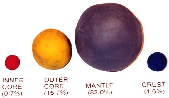
My son recently came back from a science day camp with one of the coolest things. It was a model of the Earth that he had created out of modeling clay. It showed the internal structure of the Earth, and because he built it, he was able to remember all of the layers of the Earth. Very cool. So here’s a good way to learn the Earth layers for kids.
To make your own, you need some modeling clay of different colors. You start by making a ball about 1.2 cm across. This represents the Earth’s inner core. Then you make a second ball about 3 cm across. This ball represents the Earth’s outer core. Then you make a third ball about 6 cm across. This ball represents the Earth’s mantle. And finally, you make some flattened pieces of clay that will be the Earth’s crust. To make it extra realistic, make some pieces blue and others green.
Take inner core and surround it with the outer core, and then surround that by the mantle. Cover the entire mantle with a thin layer of blue, and then put on some green continents on top of the blue.
If you’ve been really careful, you should be able to take a sharp knife and slice your Earth ball in half. You should be able to see the Earth’s layers inside, just like you’d see the real Earth’s layers. And you can see that the mantle is thicker underneath the Earth’s continents than it is under the oceans.
[/caption]
Here’s a question: how big is Earth? Let’s take a look at how big our planet is.
First, the equatorial diameter of Earth is 12,756 km. In other words, if you dug a tunnel on the equator that went straight down and went right through the center of the Earth, it would be about 12,756 km long. Just for comparison, that’s about 1.9 times the diameter of Mars. And only .09% the diameter of Jupiter.
The volume of Earth is 1.08 x 10¹² km3. Written another way, that’s 1.08 trillion cubic kilometers of rock and metal. Again, it’s about 6.6 times more volume than Mars.
The surface area of Earth is 510,072,000 square kilometers. Of that, 29.2% is covered by land and 70.8% is covered by water. Just for comparison, that’s 3.5 times as much surface area as Mars.
The mass of Earth is 5.97 x 1024 kg. Here that is written out: 5,970,000,000,000,000,000,000,000 kg. Yeah, that’s a really big number. And yet, it’s only 0.3% the mass of Jupiter (and Jupiter is mostly lightweight hydrogen).
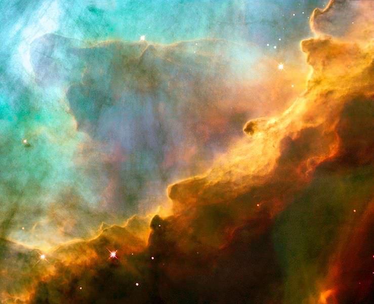
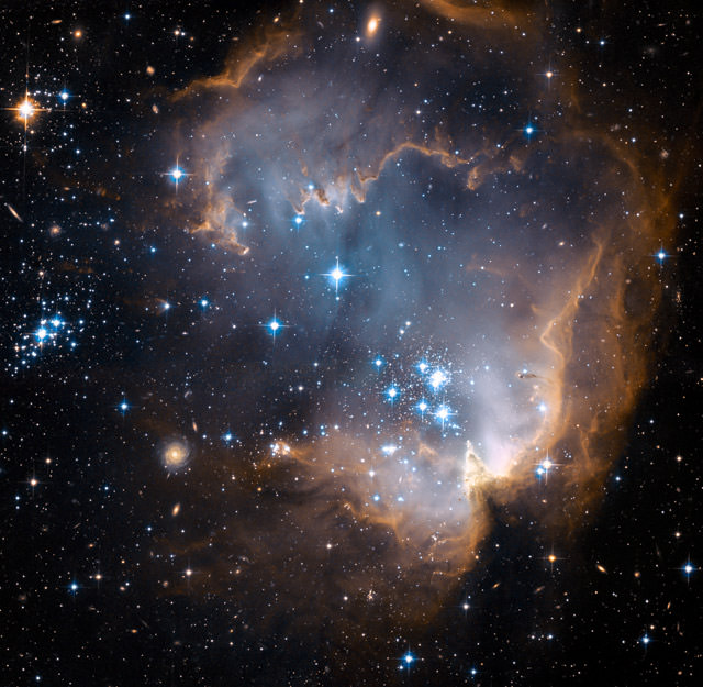
Here are some cool nebula pictures taken by the Hubble Space Telescope.
[/caption]
This is a cool picture of the Omega Nebula, which is also known as the Swan Nebula, or M 17. It’s located in the constellation Sagittarius, located about 5,000 light-years from Earth.
Cat's Eye Nebula
This is picture of the Cat’s Eye Nebula, a planetary nebula in the constellation Draco. This used to be a star similar to our Sun, but then it died and became a white dwarf, puffing off its outer layers into space.
Carina Nebula
This is the Carina Nebula, a star forming nebula in the Carina Constellation. It holds Eta Carinae, one of the most massive stars ever discovered, which is expected to detonate as a supernova in the next few hundred thousand years.
Bubble Nebula. Image credit: Hubble
This is the Bubble Nebula, also known as NGC 7635. This nebula glows because of a hot central star that’s providing radiation and exciting the nebula atoms.
Full view of the Trifid Nebula. Credit: ESO
This is a picture of the Trifid Nebula taken by the European Southern Observatory. This nebula was cataloged M 20 by Charles Messier as part of his famous catalog. It’s called the “Trifid Nebula”, because it appears to be broken up into three parts.
[/caption]
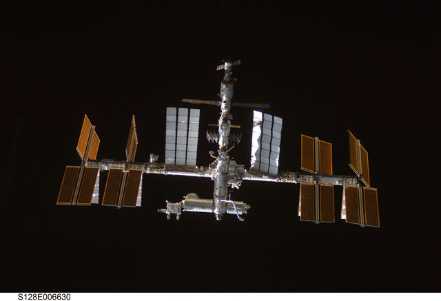
Now that it’s mostly complete, the International Space Station is the brightest human-built object in space. It’s easy to see with your own eyes, the trick is knowing when to step outside and look up to see the station go overhead. If you do get your timing right, you’ll see the station as a bright star moving quickly in the sky. It only take a couple of minutes to pass through the sky above your house. Want to see the station for yourself? Here are some resources for International Space Station viewing.
The best place to go is NASA’s Human Spaceflight tracking page. This shows you the current location of the International Space Station, the Hubble Space Telescope, and any space shuttles currently in orbit.
So that shows you where the space station and shuttles are right now, but how will you know when they’re going to be passing over your part of the Earth?
NASA has a page for sighting opportunities. You can either choose your location from a list of common locations around the world, or you download an application that lets you pick your specific spot on Earth. It will then tell you the exact times ISS will be passing overhead.
If you’ve got an iPhone, check out the ISS Visibility App. This tool will calculate the next times you’ll be able to see the ISS pass overhead.
You can also use a great service called Heavens Above. This will also show you the current location of satellites, as give you times when ISS will be passing overhead.
An astronomical unit is a method that astronomers use to measure large distances in the Solar System. 1 astronomical unit, or 1 au, is the average distance from the Sun to the Earth.
The Earth’s orbit around the Sun is actually elliptical. It varies from 147 million km to 152 million km. So the measurement of an astronomical unit is just the Earth’s average distance from the Sun. That’s where the more precise measurement of 1 AU to KM (149,598,000 km) comes from.
Here are some other distances in the Solar System:
Mercury: 0.39 AU
Venus: 0.72 AU
Mars: 1.5 AU
Jupiter: 5.2 AU
Saturn: 9.6 AU
Uranus: 19.2 AU
Neptune: 30.1 AU
Pluto: 39.5 AU
Eris: 67.7 AU
Oort Cloud: 50,000 AU
Alpha Centauri: 275,000 AU
We have written many articles about large distances in space. Here’s an article that explains how far space is, and here’s an article about the distance to stars.
Looking for a picture of Earth from Space? Here is a collection.
[/caption]
Here’s a spectacular image of the earth with the full coverage of the Pacific Ocean. This image was obtained by the Galileo spacecraft on December 12, 1990 while on its way to planet Jupiter 1.6 million miles from the Earth.
The Blue Marble from Apollo 17
This is a spectacular full view of our planet earth. It was taken by the Apollo 17 during their journey to the moon in December 7, 1972. The south polar ice cap of Antarctica can be clearly seen in the image. This region constitutes 70% of the world’s freshwater. This photo of the earth was the first to feature the south polar ice cap.
A Stormy Atlantic
Here’s an image of different storms and hurricanes forming at the Atlantic Ocean. This image was generated using the data provided by the Geostationary Operational Environmental Satellite (GOES) satellite on September 3, 2008.
Earth - Western Hemisphere
Here’s a nice view of the earth particularly focusing on the Western Hemisphere. Earth is the third planet from the sun and is the only place in the universe where life is known to exist.
The Earth-Moon System
This is a nice view of the planet earth and the moon in one frame as seen from the Galileo spacecraft 6.2 million kilometers away.
Picture of Earth from Space
Here’s a picture of Earth from Space as well as the Moon. These images were taken separately and then stitched together on computer to show them together.
Earth from Space
This picture was taken by the Space Shuttle, and shows the Earth from high orbit. You can see how the clouds rise up into the atmosphere.
Earth from space
Here’s another picture of Earth. Again, this was taken from the space shuttle.
NASA satellite map of the Earth
This is a satellite map that shows all of the Earth.
This is the classic “Blue Marble” photo of Earth.
Earth from Space at Night
Earth from Space at Night
Here’s a photo of the entire Earth, seen from space at night. You can easily see cities and towns in North America, Asia and Europe. And you can also see vast regions of the Earth which are totally dark.
Chicago at night
Here’s a photo of the city of Chicago at night. It might look upside down, but that’s because it was captured from the International Space Station as it was passing over the city.
Tokyo at night
This night space image shows the city of Tokyo at night. The blue green glow in the photograph comes from the mercury vapor lighting that lines the streets of the city.
London at night
This space pic from night shows the city of London. You can see the brightest areas are the most densely populated, and the less dense areas are dimmer. You can see the ring road that surrounds London, as well as the path of the Thames river.
Los Angeles at night
Here’s one of the brightest cities in the world. It’s Los Angeles from space, seen at night.
A Crescent Earth at Midnight
Here’s an amazing picture of the earth in crescent. This breathtaking view of our planet was obtained by the Geostationary Operational Environmental Satellite (GOES-8) on June 22, 1996. GOES is primarily assigned in monitoring the weather particularly the development of storms and hurricanes in different parts of the earth.
Earth at Twilight
This is an amazing still photo of the earth taken during its transition from day to night. This beautiful photo was taken from the International Space Station in June 2001.
All Is Illuminated
This spectacular image of the crescent earth was captured by the Optical Spectroscopic and Infrared Remote Imaging System (OSIRIS) camera on board the Rosetta spacecraft in November 2007.
Houston, Texas at Night
Here’s a nice view of Houston, Texas at night as seen from the International Space Station on February 28, 2010. This photo was taken by the crew member of the Expedition 22 mission. Houston, Texas is the world’s energy capital.
Earth from Orbit
Manicouagan Reservoir. Credit: NASA
Here’s an image of the Manicougan Reservoir situated at Canadian Shield in the province of Quebec. This was taken from the International Space Station in December 1983. Manicougan Reservoir covers an area of about 1,942 km².
Sunset
This image of the sunset on earth was captured from the International Space Station by an Expedition 13 astronaut in August 10, 2006. Expedition 13 mission was able to accomplish a total of 2,886 orbits.
Expedition 11 Earth Observation Photos
This photo shows the Central Gulf Coast obtained from the International Space Station by an Expedition 11 astronaut in September 10, 2005.
Into the Eye of the Storm
This is a photo of the eye of Hurricane Alberto taken in August 19, 2000 during the Terra orbit 3571. Hurricane Alberto is a Category 3 hurricane in the Atlantic that lasted for 19.75 days.
Hurricane Emily and the Moon
This beautiful view of the eye of Hurricane Emily and the moon was captured from the International Space Station in July 16, 2005. Hurricane Emily is a Category 5 hurricane having a maximum wind speed of 160 mph.
Earth from the Space Shuttle
Sunrise in Space
This photo of the earth’s atmosphere during sunrise was taken in July 2005 by a Discovery crew member during the STS-114 mission. STS-114 mission was the first Return to Flight mission after the unfortunate loss of the Columbia space shuttle.
Onboard View - Space Shuttle Endeavour
This image of the earth was taken from the space shuttle Endeavor during the STS-59 mission in April 12, 1994. The image particularly shows the shuttle’s payload bay and the region of the Andes Mountains in Bolivia.
Sinai Peninsula and the Mediterranean Sea
Here’s a stunning image of the Sinai Peninsula and the Mediterranean Sea as seen from the space shuttle Atlantis. A crew member of the STS-125 mission took this photo during the mission’s first flight in space.
View of the Journey Home
Here’s a unique photo of the earth’s atmosphere taken by the crew members of Atlantis’ STS-125 mission during its preparation for landing on May 20, 2009.
STS-39 view of the Aurora Australis
Here’s a great view of the Aurora Australis taken in May 1991 by the STS-39 crew member onboard the space shuttle.
Here are some cool pictures of islands… from space!
[/caption]
This is a picture of South Georgia Island, one of the southernmost islands in the world, off the tip of South America. It was used as a whaling base and now has no permanent inhabitants, other than some scientists. In this picture, taken by NASA’s Terra satellite, the entire island is covered in snow. Here are some more island pictures.
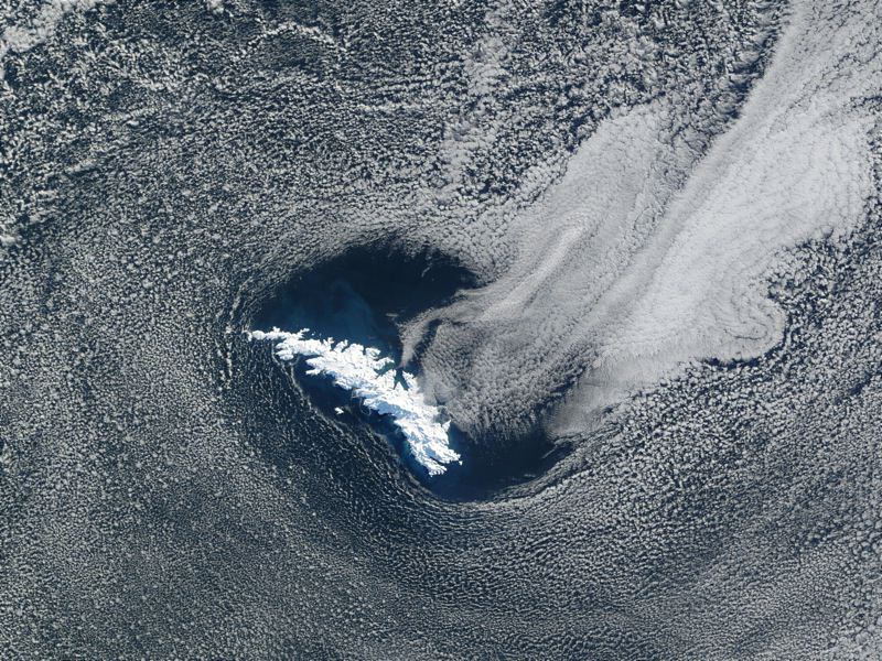
Surtsey Island
This is a picture of Surtsey Island, captured by the IKONOS satellite. This volcanic island is one of the newest in the world, breaking through the surface of the ocean in 1963. The volcanoes that formed the island erupted for about 4 years and then stopped, and now erosion from the ocean is wearing it back down again.
Ascension Island
Next in our pictures of islands is Ascension Island. You can see the airstrip down on the lower right side of the island, and a cinder cone above it. The northern part of the island has lava flows and you can see individual clouds above the island. Ascension Island is one of the space shuttle’s alternative landing sites.
Palm Island
Here’s a picture of a completely man made island. This is Palm Island, off the coast of Dubai in the United Arab Emirates. Now complete, it has palm fronds surrounded by a circular breakwater. There will eventually be more than 100 luxury hotels, marinas, water theme parks, and many houses.
Akpatok Island
This is a picture of Akpatok Island, in Northern Quebec, which is accessible only by air. The picture was taken by a Landsat satellite.
NASA has the absolute best resources on the web for pictures of space. We write so many articles about space here on Universe Today, so we’ve learned all the best places to look to get the latest and greatest NASA pictures.
Before we go right to some sites, here’s a general tip that you can use when you’re looking for NASA pictures. Use Google, but have it search for images within NASA’s sites. For example, let’s say that you’re looking for an astronomy picture of Mars, but you want it to be a NASA image. Search in Google for: mars picture site:nasa.gov. You can also switch over to the images tab and see lots and lots of images from NASA. You should be able to find the one you’re looking for.
Perhaps the best place to start is NASA’s Featured Images and Galleries. This is linked from the main NASA page and features current pictures as well as classics from the past. It also links you to other NASA image gallery sites.
Another classic is the Astronomy Picture of the Day. Keep in mind that although it’s endorsed by NASA, the pictures featured in Astronomy Picture of the Day are owned and copyright by the original photographers. So you can’t just use their pictures without asking permission first.
There’s a fairly new service out called NASA Images. It’s got a huge catalog of NASA pictures, with cool tools that let you organize and download your favorites.
The NASA Image Exchange is a huge database of NASA pictures. You can search by object, or by spacecraft and use other constraints to find the exact image you’re looking for.
The Johnson Digital Image Collection has photographs from all of NASA’s human spaceflight, from the original Mercury and Gemini flights, though the Apollo landings, right up until the space shuttle missions.
We have also recorded many episodes of Astronomy Cast about space, and we talk about NASA pictures all the time. Listen to this, Episode 88: The Hubble Space Telescope.
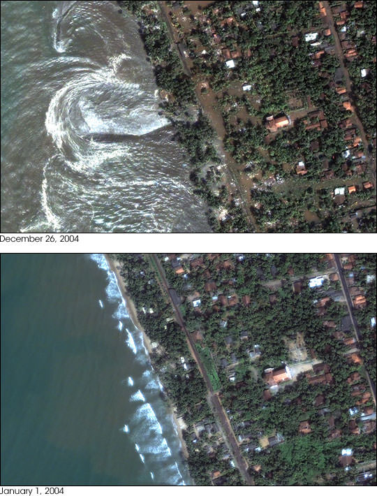
Tsunamis are some of the most devastating natural disasters. The recent Boxing Day Tsunami was generated by an enormous earthquake off the coast of Indonesia on December 26, 2004. Coastlines in Asia were inundated with enormous tsunami surges, killing more than 200,000 people.
Here are some Tsunami pictures capture by satellite that show before and after images of the regions affected by the tsunami.
[/caption]
This photograph shows the devastation that happened in Sri Lanka on December 26th. This picture was taken by the DigitalGlobe Quickbird satellite, and shows how the whole coastline was inundated with water. Devastation in Indonesia
Perhaps the most devastation from the tsunami occurred in Indonesia. This is an image of the town of Lhoknga, Indonesia. It was completely wiped off the map by the tsunami, except for the white mosque in the center of town.
Northern Sumatra
This photograph, captured by NASA’s Terra satellite shows how the whole northwest coast of the island of Sumatra was hit hard by the tsunami. It looks like the vegetation was just scraped back from the edge of the island.