Colima Volcano

Volcano Colima

[/caption]
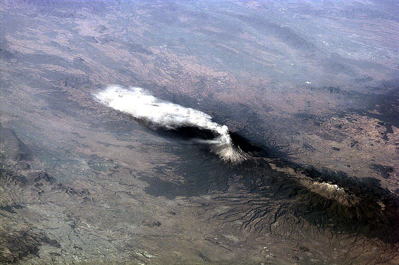
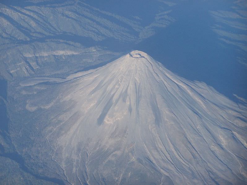
Colima is the name of a state in Mexico, as well as a city. But we’re going to be talking about another feature in Mexico, Colima’s Volcano. Colima is the most active volcano in Mexico, having erupted more than 40 separate times since records were first kept in 1576. The volcano stands at an elevation of 4,330 meters.

Geologists believe that Colima has been active for about 5 million years. Back in the Pleistocene era (between 11,000 and 1.8 million years ago), a huge earthquake triggered a landslide on the volcano, releasing 25 cubic kilometers of debris that traveled 120 km, reaching the Pacific Ocean. Major collapse events like this are believed to happen every few thousand years.

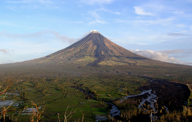
In the Colima volcano complex there are actually two different volcanoes. The older, dormant volcano is known as Nevado de Colima, and it stands at an elevation of 4330 meters. The younger, active volcano is known as the Volcan de Colima – Colima Volcano.

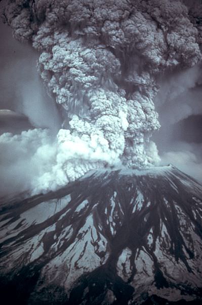
Colima has the potential to be a devastating volcano. There are about 300,000 people living within 40 km of the volcano. It has been chosen by scientists as a “Decade volcano”, and has been singled out for careful study to predict if and when a major eruptive event is happening. There have been several evacuations of the region over the last decade, since a large eruption or lava flow could affect an 11-kilometer radius around the volcano. In a 1999 eruption, Colima blasted out material that reached a distance of 5 km. Fortunately, lava flows from the volcano have never reached inhabited areas.

We have written many articles about volcanoes for Universe Today. Here’s an article about Popocatepeti, another volcano in Mexico. And here’s an article about Paricutin, a volcano that appeared in a cornfield in Mexico.

Want more resources on the Earth? Here’s a link to NASA’s Human Spaceflight page, and here’s NASA’s Visible Earth.

We have also recorded an episode of Astronomy Cast about Earth, as part of our tour through the Solar System – Episode 51: Earth.

Popocatepetl Volcano

Popocatepetl seen from space

[/caption]
Popocatepetl is a famous volcano. It is one of the most active volcanoes in Mexico, and the second tallest mountain in the country with an elevation of 5,426 meters (it’s the third tallest active volcano in the Northern Hemisphere). It’s located about 70 km southeast from Mexico City, so it can be seen on clear days from the city – especially when it’s erupting clouds of ash many km into the air. It has had more than 20 major eruptions since the arrival of the Spanish in 1519.

The name Popocatepetl comes from the Aztec word for smoking mountain. More than 30 million people live within view of the mountain, including Mexico City and the Pueblo, and hundreds of thousands would be at risk during a major eruption. Pyroclastic flows could endanger villages and towns built up on the volcano’s flanks, and although it has been relatively safe in the last century, it has had several plinian eruptions over the last 10,000 years.

The peak of Popocatepetl is clad is glaciers, and has a steep-walled 450-meter-deep crater at the top. From most vantages, the peak of the mountain looks very symmetrical; although, it does have a side peak called Ventorillo to the northwest. Geologists have determined that three previous major cones were destroyed during the Pleistocene era (between 11,000 and 1.8 million years ago).

Most of the eruptions on Popocatepetl have been mild-to-moderate Vulcanian steam and ash emissions, with some larger explosive eruptions in 1519 and 1663. In 1920, there were some explosive eruptions and a small lava plug at the crater at the top of the volcano. There have been some additional ash cloud events in the 1920s through the 1940s, but the volcano has been largely quiet since then.

We have written many articles about volcanoes for Universe Today. Here’s an article about Paricutin, a famous volcano in Mexico that appeared in a farmer’s cornfield. And here’s a list of famous volcanoes around the world.

Want more resources on the Earth? Here’s a link to NASA’s Human Spaceflight page, and here’s NASA’s Visible Earth.

We have also recorded an episode of Astronomy Cast about Earth, as part of our tour through the Solar System – Episode 51: Earth.

Soufriere Hills

Soufriere Hills

[/caption]
The Soufriere Hills volcano is an active complex stratovolcano on the Caribbean island of Montserrat. It was dormant for many years, but returned to activity in 1995 with a series of eruptions that forced the evacuation of 2/3rds of the entire island. The volcano has been continuously erupting, and has now destroyed about half the surface of the island, including the airport.

Soufriere Hills is a typical subduction volcano, created by the subduction of the Atlantic Plate underneath the Caribbean Plate. The largely andesitic volcano takes up the southern half of the island of Montserrat, rising to an elevation of 1050 meters. The summit area consists of a series of lava domes. One of the largest is English crater, measuring about 1 km across, which formed about 4,000 years ago when the summit collapsed. Previous to the 1995 eruption, Soufriere Hills was largely silent; there was an eruption in the 17th century that produced the Castle Peak lava dome.

And so, the eruption that began on July 18, 1995 was the first to hit the volcano since the 17th century. But then it started to erupt regularly with pyroclastic flows and mudflows. An eruption on June 25 killed 19 people, and completely destroyed the island’s airport. Needless to say, the island’s tourist industry was completely wiped out, and most of the inhabitants were evacuated away from the island.

Soufriere Hills is continuing to erupt regularly. A devastating eruption occurred on July 2008 without any warning, shooting out pyroclastic flows that reached the capital city of Plymouth. An ash column rose up into the air to an altitude of 12 km.

We have written many articles about volcanoes for Universe Today. Here’s an article about Mount Pelee that killed 30,000 people on the island of Martinique, and here’s an article about other famous volcanoes.

Want more resources on the Earth? Here’s a link to NASA’s Human Spaceflight page, and here’s NASA’s Visible Earth.

We have also recorded an episode of Astronomy Cast about Earth, as part of our tour through the Solar System – Episode 51: Earth.

Rincon De La Vieja

Rincon de la Vieja volcano

[/caption]
Rincon de la Vieja is an active andesitic complex volcano in Costa Rica, located about 25 km from the city of Liberia. The main summit of the volcano complex stands 1916 meters above sea level, and it’s protected in the Rincon de la Vieja Volcano National Park. It’s one of 7 active volcanoes in Costa Rica. Another name for Rincon de la Vieja is the “Colossus of Guanacaste”.

Seen from the air, Rincon del la Vieja is clearly an active volcano. There are a total of 9 major eruptive centers. You can see several large craters, with the youngest craters located in the southeast region. The last major magmatic eruption in the region happened about 3,500 years ago when about 0.25 cubic km of material was released in a plinian eruption. All the rest of the eruptions have come from the prominent crater that contains a 500-meter-wide acid lake.

There have been a total of 16 major eruptions since historical records began. The most recent event was in February, 1998, but for most of the time, the volcano just spews gasses and ash.

There are many hot bools and bubbling mud on the slopes of the volcano, and these just add to the reasons tourists visit the park. Hikers can climb up the crater, birdwatch, go river rafting, and do many other activities. Climbing to the top of Rincon del la Vieja volcano is an 8 km hike through two types of forest. The last 2 km is up a 50-degree slope. There are several lodges and hotels in the area for tourists.

We have written many articles about volcanoes for Universe Today. Here’s an article about many famous volcanoes, and here’s an article about another volcano in Costa Rica, Arenal.

Want more resources on the Earth? Here’s a link to NASA’s Human Spaceflight page, and here’s NASA’s Visible Earth.

We have also recorded an episode of Astronomy Cast about Earth, as part of our tour through the Solar System – Episode 51: Earth.

Mount Mazama

Crater Lake in Oregon. Image credit: Zainubrazvi

[/caption]
It’s not a mountain any more, but geologists refer to Mount Mazama as a peak in Oregon that used to exist before a catastrophic eruption destroyed the entire mountain and collapsed it into a giant caldera. The water-filled caldera is known Crater Lake, the deepest lake in the United States.

Mount Mazama started growing about 400,000 years ago, and it was made up of lava flows mixed with pyroclastic material. After that base was created, it switched to more explosive eruptions about 75,000 years ago. Then Mount Mazama started cone building eruptions until about 50,000 years ago. At its largest point, Mazama’s peak probably had an elevation of 3,400 meters.

Mazama started its devastating eruptions around 5677 BC with a large release of ash and pyroclastic flows. But the most devastating eruption happened 1-200 years later, when almost 60 cubic kilometers of magma was ejected out of the volcano. This emptied the magma chamber beneath the mountain, and caused it to collapse into a deep caldera. This is why Crater Lake is so deep.

Hundreds of square kilometers around the mountain were destroyed by ejected ash and deadly pyroclastic flows. One flow reached a point 64 km away down the Rogue River Valley. Ash from the explosion settled over a 1.3 million square km region of what is now the United States and Canada.

Geologists believe that there will be more volcanic activity in the future. Lava will probably make Crater Lake more shallow and eventually divide it into multiple lakes. But Mount Mazama probably won’t ever reform at the same size and structure before its detonation.

The name for Mount Mazama came from a climbing club from Portland. The were the Mazamas, and named the missing mountain after their group.

We have written many articles about volcanoes for Universe Today. Here’s a list of some of the most famous volcanoes in the world, and here’s an article about nearby Mount St. Helens.

Want more resources on the Earth? Here’s a link to NASA’s Human Spaceflight page, and here’s NASA’s Visible Earth.

We have also recorded an episode of Astronomy Cast about Earth, as part of our tour through the Solar System – Episode 51: Earth.

Mount Mayon

Mount Mayon

[/caption]
Mount Mayon, also known as the Mayon Volcano is an active stratovolcano on the island of Luzon in the Philippines. It’s located about 15 kilometers northwest of Legazpi City. Its current elevation is 2,463 meters.

This volcano is located on a convergent boundary between the Eurasian and Philippine Plate. The lighter continental plate floats over top of the oceanic plate, forcing it down, and allowing magma to well up from the Earth’s interior. This makes Mayon a very active volcano; in fact, it’s the most active volcano in the Philippines, having erupted 47 times in the last 400 years. The first recorded eruption was in 1616, and the last major eruption was on October 1st, 2006.

The most devastating eruption happened on February 1, 1814 when ash and tephra rained down around the volcano, burying a nearby town to a depth of 9 meters. 2,200 people died.

Mayon Volcano has a perfect cone shape, and hasn’t suffered any major slides or collapses of its cone (Mount St. Helens used to have a perfect cone shape too). Climbing Mount Mayon takes about 2 days to climb, with the final ascent up a 40-degree slope of volcanic cinder and lava sand.

We have written many articles about volcanoes for Universe Today. Here’s an article about Mount Pinatubo which is also in the Philippines, and here’s one about Mount Tambora.

Want more resources on the Earth? Here’s a link to NASA’s Human Spaceflight page, and here’s NASA’s Visible Earth.

We have also recorded an episode of Astronomy Cast about Earth, as part of our tour through the Solar System – Episode 51: Earth.

Mount Fuji

Summit of Mount Fuji

[/caption]
The iconic Mount Fuji is the highest mountain in Japan, and an active stratovolcano that last erupted in 1708. It can be seen from the city of Tokyo on a clear day off to the west. It stands at an elevation of 3,776 meters and is surrounded by 5 lakes.

Mount Fuji probably started erupting several hundred thousand years ago. The interior of the mountain is an andesite core that erupted first. over top of that is a basalt layer that probably erupted a few hundred thousand years ago. About 100,000 years ago, a new layer called “Old Fuji” covered that. And now the newest layer is known as, surprisingly, “New Fuji”, forming about 10,000 years go. Fuji is located at the point where the Eurasian Plate, the Okhotsk Plate and the Philippine Plate meet.

The last recorded eruption of Mount Fuji was on December 16, 1707. Eruptions lasted until January 1, 1708, with cinders and ash raining down on villages surrounding the mountain. And since then, the mountain has been quiet.

It’s believed that Mount Fuji was first climbed by a monk in 663, and the first foreigner was Sir Rutherford Alcock in September 1860. Today an estimated 200,000 people climb Mount Fuji every year. The ascent takes about 8 hours, and the descent takes just 2-3 hours to come back down.

We have written many articles about volcanoes for Universe Today. Here’s an article about other famous volcanoes, and here’s an article about Mount Pinatubo.

Want more resources on the Earth? Here’s a link to NASA’s Human Spaceflight page, and here’s NASA’s Visible Earth.

We have also recorded an episode of Astronomy Cast about Earth, as part of our tour through the Solar System – Episode 51: Earth.

Mount Stromboli

Mount Stromboli

[/caption]
Mount Stromboli is an active volcano on a small island off the north coast of Sicily – one of three active volcanoes in Italy. The volcano itself rises 924 meters above sea level, but it actually rises 2,000 meters from the floor of the ocean. It is one of the most active volcanoes in the world, erupting almost continuously for the last 2,000 years.

The eruptions of Stromboli are seen best at night, when chunks of lava blasted out of the volcano trace bright red arcs in the sky. In fact, it’s such an iconic type of eruption that geologists have named an entire class of eruptions after Mount Stromboli. Whenever you get a volcano blasting out blobs of hot lava, gas and rocks in arcs from its volcanic vent, that’s a strombolian eruption. This kind of eruption has been seen in volcanoes worldwide.

The largest (recent) eruption on Mount Stromboli happened in 1930, and resulted in the deaths of several people and the destruction of several homes. Large eruptions like this happen every decade or so. With such regular and predictable volcanic activity, tours used to go up the side of Mount Stromboli at night; the best time to see the beautiful arcs of lava. But in 2007 two new craters opened up on the island, and made the volcano less predictable. Tourists have been banned from going up to the summit to watch the volcano.

You might be surprised to know that there are 400 to 750 people living on the island of Stromboli, in the shadow of the volcano.

We have written many articles about volcanoes for Universe Today. Here’s an article about Mount Etna, and here’s an article about Mount Vesuvius; the two other active volcanoes in Italy.

Want more resources on the Earth? Here’s a link to NASA’s Human Spaceflight page, and here’s NASA’s Visible Earth.

We have also recorded an episode of Astronomy Cast about Earth, as part of our tour through the Solar System – Episode 51: Earth.

Mount Pelee

Mount Pelee

[/caption]
Mount Pelee, on the island of Martinique in the Caribbean is one of those volcanoes with such a famous and devastating eruption, that a whole class of eruptions has been named after it. In 1902, it was the source of the worst volcanic disaster of the 20th century when a pyroclastic flow blasted down its flanks and killed more than 30,000 people destroying the town of Saint-Pierre.

The volcano has an elevation of 1,397 meters, and is part of a chain of volcanoes that stretch from Puerto Rico to Venezuela. This is the point where the Caribbean Plate Meets the Atlantic Oceanic crust belonging to the South American Plate. With all this tectonic action, there are many active volcanoes in the region. Mount Pelee is a common stratovolcano, composted of many layers of lava flows and fragmented volcanic debris. The current cone formed in the last 3000 years after a previous cone collapsed in an eruption similar to Mount St. Helens.

Inhabitants of Martinique could see evidence that Mount Pelee was awakening in 1900 when activity on the volcano increased. There were relatively minor steam eruptions, and there were several minor blasts of cinders and ash. There were several larger eruptions, but these were just setting the stage for the big eruption on May 8, 1902. Observers saw the side of Mount Pelee detonate, with a dense black cloud of ash shooting out horizontally. This sent a pyroclastic flow down the slopes of the volcano, reaching and destroying the town of Saint-Pierre within a minute.

Vulcanologists have named an entire class of eruptions after what happened on Mount Pelee. Pelean eruptions describe when a volcano has a horizontal explosion on its flanks, sending out pyroclastic flows. They’re some of the most dangerous eruptions in the world.

We have written many articles about volcanoes for Universe Today. Here’s an article about pelean eruptions, and here’s an article about Mount Pinatubo.

Want more resources on the Earth? Here’s a link to NASA’s Human Spaceflight page, and here’s NASA’s Visible Earth.

We have also recorded an episode of Astronomy Cast about Earth, as part of our tour through the Solar System – Episode 51: Earth.

Famous Volcanoes

Mount St. Helens eruption in 1981

[/caption]
At any time there are about 20 volcanoes actively erupting around the world, and about 50-70 volcanoes have erupted in the last year or so. There are a total of 550 volcanoes that have erupted in all of recorded history. Some of these active volcanos are extremely famous, often because of a tremendous loss of life. Here’s a list of some famous volcanoes:

Caribbean

  • Mount Pelee – A stratovolcano on the island of Martinique that killed more than 30,000 people during an eruption in 1902.
  • Soufriere HillsA dormant volcano that returned to life in 1995 forcing the evacuation of the island of Montserrat.

Volcanoes in Costa Rica

  • Arenal Volcano
  • Barva Volcano
  • Irazu Volcano
  • Poas Volcano
  • Rincon de la Vieja
  • Turrialba Volcano

Volcanoes in Guatemala

  • Fuego
  • Pacaya
  • Santa Maria

Ecuador

  • Cotopaxi – A very active volcano in Ecuador, popular with hikers.
  • Chimborazo – This dormant stratovolcano is the highest point in Ecuador, and actually the most distant point from the center of the Earth.
  • Cayambe – Another dormant stratovolcano in Ecuador. It’s the third tallest peak in the country.

Greece

  • Thera – The volcano that devastated the island of Santorini; one of the most powerful volcano eruptions in recorded history.

Indonesia

  • Krakatoa – This used to be an island in the Sunda Strait near the island of Java. It exploded in 1883 creating one of the largest eruptions in recorded history.
  • Mount Tambora – A stratovolcano on the island of Sumbawa in Indonesia. It exploded in 1815 producing the most powerful eruption in recorded history.
  • Mount Merapi – An active volcano in Indonesia, on the island of Java near the city of Yogyakarta. It’s so active that ash is almost constantly coming out the top of the volcano, and it has had several recent devastating eruptions.

Italy

  • Mount Etna – An active volcano on the Island of Sicily. It’s in an almost constant state of eruption, with huge ash clouds visible from the island.
  • Mount Vesuvius – A dangerous volcano near Italian city of Naples. It’s most famous for the devastating eruption in AD 79 that destroyed the towns of Pomeii and Herculaneum.
  • Mount Stromboli – An active volcano just off the coast of Sicily. It has been constantly erupting for the last 2,000 years or so.

Japan

  • Mount Fuji – The iconic Japanese stratovolcano – the highest point in Japan.

Mexico

Philippines

  • Mount Pinatubo – An active stratovolcano in the Philippines that erupted in 1991, producing the second most powerful eruption in the 20th century.
  • Mount Mayon – This stratovolcano in the Philippines has one of the most perfect cones of all the volcanoes in the world.

United States (Hawaii volcanoes)

  • Mauna Loa – This active shield volcano is the second tallest volcano in the world, but it’s the biggest volcano in the world, with the most volume. It has erupted within the last century.
  • Hualalai – The third most active volcano in Hawaii.
  • Kilauea – An active volcano on the eastern side of the Island of Hawaii. It’s in an almost constant state of eruption, and one of the most active volcanoes in the world.
  • Kohala – The oldest of the 5 volcanoes on the Big Island of Hawaii.
  • Mauna Kea – The tallest volcano in the world, located on the Big Island of Hawaii.
  • Mount St. Helens – An active volcano in Washington State. It detonated in 1980, destroying thousands of square km of forest and killed 57 people.
  • Mount Mazama – This is the name for the stratovolcano that exploded more than 7000 years ago, creating what is now Crater Lake in Oregon.
  • Mount Rainier – An active stratovolcano that dominates the skyline over Seattle. 150,000 people live on mudflows that erupted out of the volcano 5,000 years ago.

Want more resources on the Earth? Here’s a link to NASA’s Human Spaceflight page, and here’s NASA’s Visible Earth.

We have also recorded an episode of Astronomy Cast about Earth, as part of our tour through the Solar System – Episode 51: Earth.

Reference:
USGS Volcano Hazards Program