Mount Merapi

Mount Merapi

[/caption]
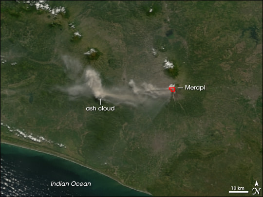
Mount Merapi is an active volcano in Indonesia, on the island of Java near the city of Yogyakarta. The volcano is so active that smoke can be seen coming out of the peak almost every day of the year. Mount Merapi has been erupting regularly since 1548.

Mount Merapi is located in the subduction zone, where the Indo-Australian Plate is going under the Eurasian Plate. Geologists estimate that the volcano started forming 400,000. It was largely built up by basaltic lava flows, but the lava flows have become more viscous in the last 10,000 years or so. With the thicker lava, Merapi has had more explosive eruptions and the formation of lava domes. Merapi has minor eruptions every 2 years or so, and major eruptions every few decades.

Even though it’s an extremely active volcano, thousands of people live on its flanks. Hot gas killed 43 people in 1994, and 13 villages and 1400 people were killed by pyroclastic flows during an eruption in 1930. A series of earthquakes struck Mount Merapi in April/May 2006, the most powerful one on May 27th killed 5,000 people. An eruption on June 14, 2006 spewed out a cloud of volcanic ash that covered a village several kilometers away.

We have written many articles about volcanoes for Universe Today. Here’s an article about Mount Pinatubo, and here’s an article about Mount Tambora.

Want more resources on the Earth? Here’s a link to NASA’s Human Spaceflight page, and here’s NASA’s Visible Earth.

We have also recorded an episode of Astronomy Cast about Earth, as part of our tour through the Solar System – Episode 51: Earth.

Mount Tambora

Mount Tambora

[/caption]
Mount Tambora is an active stratovolcano on Sumbawa island in Indonesia. It once measured 4,300 meters tall, making it one of the tallest mountains in Indonesia. It’s most famous for an enormous eruption in 1815, when the volcano detonated in the most powerful eruption in recorded history. After 150 cubic kilometers were blasted out of the volcano, and the caldera collapsed, Tambora had dropped down to 2,700 meters.

Tambora had only 3 eruptions over the previous 5,000 years, and none were very severe. But in 1812, Mount Tambora became much more active, culminating in a series of eruptions in April, 1815. On the evening of April 10th, 1815, witnesses saw three huge columns of flame rising up from the volcano. Pumice rocks rained down around the volcano, followed by clouds of ash a few hours later.

Geologists have estimated that Mount Tambora erupted with a force of 7 on the Volcanic Explosivity Index; that’s 4 times more powerful than the 1883 Krakatoa eruption. The ash cloud reached Borneo and Sulawasi islands, located 1,300 kilometers away. Historians argue how many deaths caused by the eruption itself, but estimates range from 10,000 killed by the eruption outright to almost 100,000 when you include the disease and starvation after the eruption.

The effects from the Mount Tambora eruption were felt around the world. It released so much sulphur into the atmosphere that the entire planet was cooled. The following year was known as the year without a summer. Snow fell in Quebec in the middle of summer, and persistent fog obscured much of the Northeastern US. Average annual temperatures dropped by 0.4 to 0.7 degrees C. It created the worst famine in the 19th century.

We have written many articles about volcanoes for Universe Today. Here’s an article about Mount St. Helens, and here’s another about Mount Pinatubo.

Want more resources on the Earth? Here’s a link to NASA’s Human Spaceflight page, and here’s NASA’s Visible Earth.

We have also recorded an episode of Astronomy Cast about Earth, as part of our tour through the Solar System – Episode 51: Earth.

Mauna Kea

Mauna Kea. Image credit: USGS

[/caption]
The shield volcano Mauna Kea is the tallest volcano on Earth, rising to a summit of 4,205 meters above sea level. It’s one of the 5 volcanoes that make up the Big Island of Hawaii. Mauna Kea means “white mountain” in the Hawaiian language because its summit is regularly covered in snow during the winter.

Scientists believe that Mauna Kea began erupting about 1 million years ago. It’s fed by magma from the Hawaiian hotspot; a volcanic vent that continues to pump out magma while the Pacific Plate slowly moves over top of it. This has created a chain of islands thousands of kilometers long called the Hawaiian archipelago. It’s believed that Mauna Kea transitioned from an active volcano to a post-shield stage of volcanic evolution about 200,000 to 250,000 years ago. The last eruption was thought to have occurred about 4000-5000 years ago.

Because of its high altitude, the peak of Mauna Kea is an excellent spot for astronomical observing. The summit of the volcano is above 40% of the Earth’s atmosphere, and 90% of the water vapor, allowing for extremely clear skies. Some of the largest, most powerful telescopes in the world are located atop Mauna Kea, including the Keck observatories, and the Gemini North telescope.

During the winter, Mauna Kea is coated in a thin layer of snow, and there are regions on the mountain where you can ski or snowmobile. And scientists have discovered evidence that large glaciers formed during the last period of world wide glaciation – about 11,000 years ago.

We have written many articles about volcanoes for Universe Today. Here’s an article about Mauna Loa, and here’s an article about Kilauea.

Want more resources on the Earth? Here’s a link to NASA’s Human Spaceflight page, and here’s NASA’s Visible Earth.

We have also recorded an episode of Astronomy Cast about Earth, as part of our tour through the Solar System – Episode 51: Earth.

Mauna Loa

Mauna Loa. Image credit: USGS

[/caption]
Earth’s largest volcano is Mauna Loa, located on the Big Island of Hawaii. Although it only rises 4 km above the surface of the Pacific Ocean, that’s just the tip of the iceberg. Mauna Loa descends another 5 km down to the sea floor, which has been pushed down another 8 km by the mass of Mauna Loa. When you add that all up, the summit of Mauna Loa is 17 km above its base. It’s not the tallest volcano on Earth, though, it’s actually 37 meters shorter than Mauna Kea.

Half of the island of Hawaii is made up by Mauna Loa, and it amounts to 85 percent of all the other Hawaiian islands combined. Scientists believe that Mauna Loa has been erupting for at least 700,000 years, and may have emerged above sea level 400,000 years ago. Furthermore, Mauna Loa is one of the world’s most active volcanoes having erupted 33 times since detailed records began in 1843. Its most recent eruption was in 1984, and it’s almost certain to erupt again in the near future.

As with all of the Hawaiian volcanoes, Mauna Loa gets its magma from the Hawaiian hotspot. This is a chamber of magma that has created all the islands in the Hawaiian archipelago. The slow movement of the Pacific Plate has created a succession of volcanic islands that stretch thousands of km across the ocean. Nearby Mauna Kea is dormant, Mauna Loa is active and the smaller Kilauea is in an almost constant state of eruption.

Mauna Loa is a shield volcano. This means it has wide, gently sloping flanks. The basalt lava that erupts out of Mauna Loa and the other Hawaiian Islands has a high viscosity, and can flow for dozens of kilometers. Explosive eruptions on shield volcanoes are rare. Scientists have detected a magma chamber about 3 km below the surface of Mauna Loa, and smaller chambers beneath rift zones on the volcano’s flanks.

We have written many articles about volcanoes for Universe Today. Here’s an article about Kilauea, and here’s an article about Krakatoa.

Want more resources on the Earth? Here’s a link to NASA’s Human Spaceflight page, and here’s NASA’s Visible Earth.

We have also recorded an episode of Astronomy Cast about Earth, as part of our tour through the Solar System – Episode 51: Earth.

Mount Pinatubo

Mount Pinatubo is an active stratovolcano on the island of Luzon in the Philippines, and the site of one of the most powerful recent eruptions. In June 1991, the volcano produced the second largest terrestrial eruption of the 20th century (after Novarupta), and the largest eruption in living memory. At least 800 people lost their lives in the eruption, but this was lower than it could have been because of an organized evacuation effort.

Pinatubo is located in the Cabusilan Mountain range, located on the west coast of the Island of Luzon. It’s a stratovolcano made up of successive layers of andesite and dacite. Its richly forested slopes were home to several thousand indigenous people. Before the eruption, it rose to an elevation of 1745 meters, but now it’s only 1485 meters tall.

Scientists had many warnings that Pinatubo was about to erupt, and this allowed such a thorough evacuation. On July 16, 1990, a magnitude 7.8 earthquake struck about 100 km north of Pinatubo. And then in March/April 1991, molten rock was detected rising to the surface from more than 32 kilometers beneath Pinatubo. This triggered more small earthquakes through April, May and early June.

On June 12, 1991, millions of cubic meters of magma reached the surface, beginning several days of eruptions. Even more magma reached the surface on June 15th, ejecting more than 5 cubic kilometers of material. An ash cloud rose 35 kilometers into the air, covering the surrounding region in meters of ash. Dangerous pyroclastic flows of hot ash, rock and water surged down the sides of the volcano, destroying everything in their path. The huge eruption gouged out a caldera 2.5 km across.

The eruption was so significant that the ash darkened the atmosphere, and caused worldwide temperatures to drop by 0.5 degrees C.

We have written many articles about volcanoes for Universe Today. Here’s an article about Mount St. Helens, and here’s an article about Krakatoa.

Want more resources on the Earth? Here’s a link to NASA’s Human Spaceflight page, and here’s NASA’s Visible Earth.

We have also recorded an episode of Astronomy Cast about Earth, as part of our tour through the Solar System – Episode 51: Earth.

Mount St. Helens

Eruption of Mount St. Helens

[/caption]
The most powerful and devastating volcanic eruption in the history of the United States was the explosion of Mount St. Helens. This active stratovolcano, located in Skamania County, Washington detonated on May 18, 1980, killing 57 people, destroying hundreds of homes, and flattening hundreds of square kilometers of forest. The eruption tore off the top of the mountain, reducing its height from 2,950 meters to 2,550 meters.

Mount St. Helens is just one volcano in the Cascade Range of mountains that stretch down the west coast of North America. There are many other famous volcanoes in this region, like Mount Ranier, Mount Hood, and Mount Shasta. Helens is a large eruptive cone made up of several layers of lava rock interlaced with ash, pumice and other deposits. There are layers of basalt and andesite, and several domes of dacite lava have broken through.

Scientists believe that Mount St. Helens started forming about 40,000 years ago, and it’s considered the most active volcano in the Cascade Range. Before its eruption, St. Helens was the 5th-highest peak in Washington state; it was nicknamed the Mount Fuji of America. It measures about 10 km across the base and rose about 1,500 meters above the surrounding landscape.

And so, on May 18, 1980, Mount St. Helens erupted catastrophically, after nearly 2 months of local earthquakes and steam eruptions – scientists measured more than 10,000 minor earthquakes leading up to the eruption. But it was a magnitude 5.1 earthquake on May 18th that caused the volcano’s bulging north flank to slide away in the largest landslide in recorded history. This released a huge blast of hot gas, steam and rock debris that swept downhill from the summit. This pyroclastic flow melted snow and ice on the mountain, which added to the torrent of material streaming down the river valleys leading from the volcano. A plume of ash rose 19 kilometers into the air, covering 57,000 square kilometers of the Western United States.

Mount St. Helens is still active, and scientists have discovered dozens of extrusions of thick, pasty lava. A new dome is taking shape. It’s now about 1,100 meters in diameter and 250 meters tall.

We have written many articles about volcanoes for Universe Today. Here’s an article about Kilauea in Hawaii, and here’s an article about Krakatoa.

Want more resources on the Earth? Here’s a link to NASA’s Human Spaceflight page, and here’s NASA’s Visible Earth.

We have also recorded an episode of Astronomy Cast about Earth, as part of our tour through the Solar System – Episode 51: Earth.

References:
http://vulcan.wr.usgs.gov/Volcanoes/MSH/May18/summary_may18_eruption.html
http://vulcan.wr.usgs.gov/Volcanoes/MSH/Publications/Bulletin1859/eruption_may18_1980.html

Kilauea Volcano

Lava fountain in Hawaii.

[/caption]
The Hawaiian Island chain is a long string of islands that actually stretches for thousands of km. All of these islands were formed by the movement of the Pacific plate above a volcanic hotspot. As the plate is constantly slowly moving, it allowed volcanic islands to form and then carried them away so they would become extinct. There are 5 shield volcanoes on the Big Island of Hawaii, with Kilauea being the newest and most active.

Kilauea is located on the Eastern edge of the Big Island of Hawaii. It rises only 1,247 km above sea level; a fraction of its neighbor Mauna Loa, which rises to 4,169 km. It’s classified as part of a family of low, broad volcanoes known as shield volcanoes. The basaltic lava that erupts out of shield volcanoes has a low viscosity which can flow for dozens of kilometers. While the other volcanoes on the island are extinct or dormant, Kilauea is in an almost constant state of eruption.

Scientists used to think that Kilauea was a satellite volcano of the larger Mauna Loa, but better research has shown that Kilauea has its own magma plumbing system, starting more than 60 km below the surface of the Earth. Kilauea has almost continuous activity during the 19th century, and there were 34 eruptions since 1952. In January 1983, eruptions began along the east rift zone and haven’t stopped since.

Kilauea is one of the most accessible volcanoes in the world. You can drive right up to it, park, and walk down a short trail to peer into the volcano crater. There’s even a lodge on the ridge that gives an amazing view of the volcano. One of the best ways to view Kilauea is by boat. Tours will take visitors just offshore, where hot lava is pouring out of Kilauea and into the Pacific Ocean. This creates huge plumes of steam.

The inhabitants of the Hawaiian Islands believed that the goddess of volcanoes, Pele, lived in Kilauea. They thought that eruptions happened when their goddess was angry, and they developed many tribal chants to try and calm her down. Several unique lava formations are named after her, like Pele’s tears (small drops of lava that cooled in mid air during an eruption), and Pele’s hair (strands of volcanic glass).

We have written many articles about volcanoes for Universe Today. Here’s an article about Mount Vesuvius, and here’s an article about Mount Etna.

Want more resources on the Earth? Here’s a link to NASA’s Human Spaceflight page, and here’s NASA’s Visible Earth.

We have also recorded an episode of Astronomy Cast about Earth, as part of our tour through the Solar System – Episode 51: Earth.

Reference:
USGS Volcano Information Page: Kilauea

Krakatoa

Illustration of the Krakatoa eruption.

[/caption]
Perhaps the most famous volcanic eruption in recent history is the explosion of the volcano Krakatoa in 1883. On August 27 a series of four explosions almost entirely destroyed the island. People as far away as Perth in Western Australia could hear the detonation, and it’s estimated that 120,000 people died from the eruption. In fact, the entire climate of Earth was affected for several years after the eruption, as global temperatures dipped for 5 years.

What’s left of Krakatoa is a small group of islands located in the Sunda Strait, which divides Sumatra from the Island of Java. It’s located directly above the subduction zone of the Eurasian Plate and the Indo-Australian Plate, where the plates make a change in direction. It’s believed that the volcano’s caldera collapsed in 416 AD, forming a 7-km wide caldera. The remnants of this eruption formed Verlaten and Lang Islands. Three volcanoes (Rakata, Danan and Perbuwatan) came together to form the pre-1883 Krakatau island.

Krakatau was made up of one or more stratovolcanoes that went through 5 major periods. The first was an early growth phase, followed by the formation of the caldera. Then the caldera collapsed, and was destroyed during the 1883 eruption. A new growth phase began in December 27, and even now Krakatoa is growing by more than 12 cm/year.

The destruction of Krakatoa began on May 20, 1883 when a mild ash and steam eruptions started up. There were similar eruptions for about 3 months, and at times several vents were erupting at the same time. On August 11, large ash columns rose from the main crater of Perbuwatan. These small eruptions intensified over time, leading to the August 27th explosion that caused the collapse of the caldera.

Although the eruption of Krakatau was devastating, scientists think that many people lost their lives from the giant tsunami generated by the eruption. The largest wave reached 40 meters and killed around 34,000 people. In one case, a ship was carried 2.5 kilometers inland and dumped into the forest.

Scientists measuring the strength of volcanic eruptions using a scale called the Volcanic Explosivity Index (VEI). The eruption at Krakatau measured VEI 6 on the scale, and ejected 16 cubic kilometers of material. Anything within 16 km was covered with 16 meters of ash. Even towns located more than 450 km away were coated with a few cm of ash.

We have written many articles about volcanoes for Universe Today. Here’s an article on Mount Etna, and here’s an article on Mount Vesuvius.

Want more resources on the Earth? Here’s a link to NASA’s Human Spaceflight page, and here’s NASA’s Visible Earth.

We have also recorded an episode of Astronomy Cast about Earth, as part of our tour through the Solar System – Episode 51: Earth.

References:
http://vulcan.wr.usgs.gov/Volcanoes/Indonesia/description_krakatau_1883_eruption.html
http://hvo.wr.usgs.gov/volcanowatch/2003/03_05_22.html

Universe Today is Hiring… a Researcher

Universe Today has a new position open for a researcher, and we were wondering if anyone out there on the Internets is interested in applying.

We’re looking for a researcher who can help support the blogging team to find space and astronomy news stories and aggregate them together. This means tracking thousands of RSS feeds, watching twitter feeds until your eyes bleed, and lurking through many many discussion forums. You’ll cosy up to NASA press officers and university researchers, deriving hidden meaning from their slightest innuendo. And then, like a mighty hunter, you’ll return to Universe Today HQ with a bag filled with breaking space news to keep the bloggers busy.

Are you the right person for the job? Ask yourself:

  • Do you love space and astronomy?
  • Do you love to make lists? Do you have lists of your lists?
  • Do you have a burning need to know everything? Does it annoy you that somebody out there might know something that you don’t?
  • Do you have a strong opinion of what’s interesting, and what’s boring. What’s cool and what’s lame?
  • Are your friends tired of you telling them cool stuff you’ve found out? (we’ll never tire of it)
  • Do you already have a fully stuffed RSS reader pulling in stories from all directions like a hungry black hole?

I’m thinking that this’ll be a part-time job – 20 hours/week? And you’ll be able to work from the comfort of your own home – in any country. Oh, and it doesn’t pay very well. But it does pay.

So, if that’s you, send in an email to [email protected] and tell me your story.

Basalt

Lava fountain in Hawaii.

[/caption]
Basalt is a hard, black volcanic rock with less than 52% silica. Because of this low silica content, basalt has a low viscosity (thickness), and so it can flow for long distances after erupting from a volcano. During an eruption, a basalt lava flow can easily move more than 20 km away from a vent. Basalt is the most common rock type in the Earth’s crust. In fact, most of the ocean floor is made up of basalt.

Basalt is made up of dark colored materials like pyroxene and olivine, but it also contains lighter minerals like feldspar and quartz. These crystals form because the lava cools slowly after erupting out of a volcano. Although a lava flow might look cool shortly after an eruption, it might take months or even years to cool all the way through. The crystals are bigger in the middle of a cooled lava flow because that part had longer to cool. If a lava flow cools quickly, like when it falls into a lake or ocean, it becomes a glass-like rock called obsidian. This is because the crystals in the rock don’t have time to form.

Shield volcanoes are made up entirely of basalt lava eruptions. A good example of this are the volcanoes Mauna Loa and Mauna Kea on the Big Island of Hawaii. Over hundreds of thousands of years, they have built up tall volcanoes that are extremely wide because of the fast flowing basalt lava.

Geologists have found large outpourings of lava covering hundreds of kilometers of land called flood basalt. The largest of these is known as the Siberian Traps in northern Russia. This is a region of 1.5 million square kilometers covered by basalt.

We have written many articles about volcanoes for Universe Today. Here’s an article about obsidian, and here’s an article about different types of lava.

Want more resources on the Earth? Here’s a link to NASA’s Human Spaceflight page, and here’s NASA’s Visible Earth.

We have also recorded an episode of Astronomy Cast about Earth, as part of our tour through the Solar System – Episode 51: Earth.