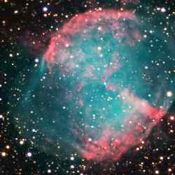
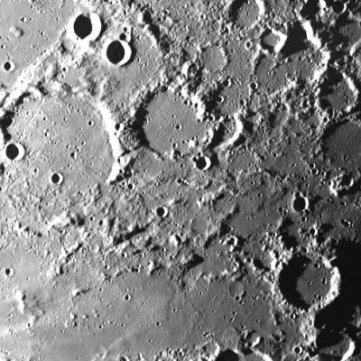
Image credit: R Jay GaBany. Click to enlarge

Space and astronomy news
Image credit: R Jay GaBany. Click to enlarge

Hayabusa descending on Itokawa before landing. Image credit: JAXA Click to enlarge
Hayabusa attempted its first soft-landing on Itokawa for the purpose of touch down and sample collection on November 20-21, 2005. Below is the data information with the related advance report on its status.
Hayabusa started descending at 9:00pm on Nov. 19th, 2005 (JST) from 1km in altitude. The guidance and navigation during the process of approach was operated normally, and at 4:33am on Nov. 20th, the last approach of vertical descent was commanded from ground, of which soft-landing was successfully achieved almost on the designated landing site of the surface. Deviation from the target point is now under investigation but presumed within a margin of 30cm.
The velocity at the time of starting descent was 12cm/sec. At the altitude 54m at 5:28am, wire-cutting of target marker was commanded, after which, at 5:30am at altitude 40m, the spacecraft autonomously reduced its own speed by 9cm/sec to have substantially separated the target marker. It means that Hayabusa’s speed became 3 cm/sec. Separation and freefall of the marker was confirmed from the image as well as from descending velocity of the spacecraft at the time of reducing the speed. The marker is presumed to have landed on southwest of MUSES Sea.
Hayabusa then switched its range measurement from Laser Altimeter (LIDAR) to Laser Range Finder (LRF) at the altitude 35m and moved to hovering by reducing descending speed to zero at 25m above the surface, below where Hayabusa, at 5:40am at altitude 17m, let itself to freefall, functioning itself to the attitude control mode adjustable to the shapes of the asteroid surface. At this point, the spacecraft autonomously stopped telemetry transmission to the earth (as scheduled) to have changed to transmission with beacon mode more efficient for Doppler measurement by switching to low gain antenna (LGA) coverable larger area.
Since then, checking of the onboard instruments was not possible on a real time basis (as scheduled), but as a result of analyzing the data recorded onboard and sent back to the earth in the past two days, Hayabusa seemed to have autonomously judged to abort descending and attempted emergency ascent because its Fan Beam sensors for obstacle checking detected some kind of catch-light. Allowable margin is set for Hayabusa for its attitude control, in the case the spacecraft takes off the ground by accelerating the velocity on its own. Under such circumstances, the then spacecraft’s attitude was out of the margin, because of which continuing of safe descent was consequently chosen. As a result, Hayabusa did not activate its Touch Down Sensor function.
At the timepoint of Nov. 21, Hayabusa was judged not to have landed on the surface. According to the replayed data, however, it was confirmed that Hayabusa stayed on Itokawa by keeping contact with the surface for about 30 minutes after having softly bounced twice before settling. This can be verified by the data history of LRF and also by attitude control record.
This phenomenon took place during switching interval from Deep Space Network (DSN) of NASA to Usuda Deep Space Center, because of which the incident was not detected by ground Doppler measurement. The descending speed at the time of bouncing twice was 10cm/sec. respectively. Serious damage to the spacecraft has not been found yet except heating sensor that may need checking in some part of its instrument.
Hayabusa kept steady contacting with the surface until signaled from ground to make emergency takeoff at 6:58am (JST). The Touch Down Sensor supposed to function for sampling did not work because of the reason above stated, for which reason firing of projector was not implemented in spite of the fact that the spacecraft actually made landing. The attitude at landing is so presumed that the both bottom ends of +X axis of sampler horn and either the spacecraft or tip end of the solar panels was in contact with the surface. Hayabusa became the world-first spacecraft that took off from the asteroid. Really speaking, it is the world-first departure from an celestial body except the moon.
After departure from the asteroid by ground command, Hayabusa moved into safe mode due to the unsteady communication line and the conflict with onboard controlling and computing priority. The comeback from safety mode to normal 3-axis control mode needed full two days of Nov. 21 and 22. Owing to this reason, replaying of the data recorded on 20th is still midway, which means the possibility to reveal much more new information through further analysis of the data. As of now, the detailed image of the landing site to know its exact location has not been processed yet. Hayabusa is now on the way to fly over to the position to enable landing and sampling sequence again. It’s not certain yet if or not descent operation will be able to carry out from the night of Nov. 25 (JST). We will announce our schedule in the evening of Nov. 24.
Descending and landing operation will all depend upon availability of DSN of NASA. We would like to express our sincere gratitude for cooperation of NASA for tracking networks including backup stations.
Original Source: JAXA News Release

The lunar surface taken by SMART-1. Image credit: ESA Click to enlarge
While the Earth is tilted at an angle of about 23 degrees, the moon’s tilt is just over 1 degree. Because of this, the summits of some lunar crater rims are sunlit over very long periods. In some locations, there are “peaks of eternal light,” or pics de lumiere eternelle, as the French astronomer Camille Flammarion called them at the end of the nineteenth century.
NASA’s Clementine spacecraft orbited the moon for three months in 1994. It identified some spots in the north polar region that are illuminated all the time during the summer, and others that are illuminated 80 percent of the time. This was not a big surprise, because we know that on Earth the poles receive a lot of sunlight during the summer. A question that the European Space Agency wanted to answer with the SMART-1 mission was whether there is enough solar light to still illuminate these places in winter.
SMART-1 mapped the polar areas on the moon, and we recently found an illuminated site about 15 kilometers from the north pole. Even though most of the moon is dark in that region, there’s a crater wall tall enough for sunlight to strike its rim.
Such perpetually lit areas would be good places to start our exploration of the moon. If you didn’t want to rely on complex power systems, you could install solar power stations at the peaks and use the energy to run small rovers and landers. Such systems are easier to design than electrical and mechanical systems that must withstand the extreme variation of temperature between lunar day and night. Branching out from there, you could build a spider web of facilities and habitats, with the core feeding energy to surrounding areas.
A peak of eternal light would be a good place to retreat to in winter, where we could maintain low level operations. In the spring and summer, we could reach out to other parts of the moon, extending hundreds of kilometers from the core.
The peaks provide some temperature stability. On the moon’s equator, the temperature can vary from minus 170 degrees C to plus 110 degrees C. The peaks have less variation, and an average temperature of minus 30 degrees C. A solar collector placed on a peak could provide enough energy to maintain a habitat with a very comfortable temperature of 20 degrees C.
With such a stable environment, you could do life science experiments to test how life adapts on another world. We could see how bacteria withstand the radiation environment. We could develop plant growth experiments in preparation for human bases.
But we also want to know if different organisms can survive and proliferate in the extreme conditions of the moon. By experimenting with different temperatures, artificial pressure, and other factors, we could figure out whether we even needed to develop lunar greenhouses. Do we need to recreate an exact copy of Earth conditions, or can we just adapt aspects of lunar conditions and make use of local resources?
Some astronomers are interested in the peaks of eternal light. You could build a very large observatory, at some distance from a peak of eternal light, that could observe the universe unattended. Because there’s no atmosphere on the moon, sunlight does not get scattered, so you can make observations even during part of the daytime.
Finally, just as the moon’s axis of rotation produces peaks of eternal light, there are also places, like the bottoms of some craters near the poles, that are in permanent shadow. We are very interested in such craters because they may contain water ice. That could be a valuable resource for future bases on the moon.
So a peak of eternal light would be a good central base from which to begin our lunar activities. It could provide a source of solar power for exploration, astronomical observations, life science experiments, and the investigation of possible water in the dark craters.
To extend beyond a few hundred kilometers from the peaks, however, we would need to develop nuclear power systems. That would provide enough energy to allow us to grow from a little refuge to a global village on the moon.
Original Source: NASA Astrobiology
I’m #126, I’m #126! Okay, according to Feedster’s Top 500 blogs on the Internet, Universe Today is #126. Not bad when you consider there are millions of blogs out there. And especially considering that Universe Today isn’t really a blog. In fact, I think I just got suckered into promoting Feedster. 🙂
But I want to take a moment out of my self-congratulation and point your browsers towards my RSS feed, which I suppose is Universe Today’s most blogesque feature. If you’re reading this article from the website, or in my email newsletter, you really should consider switching over to the RSS feed. I make a compelling case on this page. Don’t worry, I’ll keep putting out both web and email editions, but it’s such a better way to get news.
See you in the top 100!
Fraser Cain
Publisher
Universe Today
P.S. And you should listen to my Podcast too. Okay… I’m done.

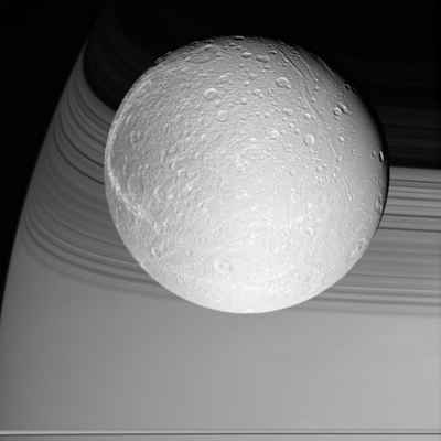
Saturn’s Moon Dione. Image credit: NASA/JPL/SSI Click to enlarge
Cassini prepared for its rendezvous with Dione on Oct. 11, 2005, capturing the brilliant, cratered iceball in front of its shadow-draped planet.
The terrain seen here becomes notably darker toward the west, and is crosscut by the bright, fresh canyons that form wispy markings on Dione’s trailing hemisphere. Dione is 1,126 kilometers (700 miles) across.
The image was taken in visible light with the Cassini wide-angle camera at a distance of approximately 24,500 kilometers (15,200 miles) from Dione and at a Sun-Dione-spacecraft, or phase, angle of 22 degrees. The image scale is about 2 kilometers (1 mile) per pixel.
The Cassini-Huygens mission is a cooperative project of NASA, the European Space Agency and the Italian Space Agency. The Jet Propulsion Laboratory, a division of the California Institute of Technology in Pasadena, manages the mission for NASA’s Science Mission Directorate, Washington, D.C. The Cassini orbiter and its two onboard cameras were designed, developed and assembled at JPL. The imaging operations center is based at the Space Science Institute in Boulder, Colo.
For more information about the Cassini-Huygens mission visit http://saturn.jpl.nasa.gov. The Cassini imaging team homepage is at http://ciclops.org .
Original Source: NASA/JPL/SSI News Release

NASA’s Mars Exploration Rover Spirit. Image credit: NASA/JPL-Caltech. Click to enlarge
Spirit, the untiring robotic “wonder child” sent by NASA to explore the eerily earthlike fourth planet from the sun, has completed one martian year–that’s almost two Earth years–on Mars. Designed to last only 90 martian days (sols), the six-wheeled marvel the size of a golf cart has pursued a steady course of solar-driven geologic fieldwork, bringing back some 70,000 images and a new understanding of Mars as a potential habitat.
During Spirit’s martian year, the seasons have changed from summer to winter and back again. In its orbit around the Sun, Mars has returned to where it was when the rover first landed. Having survived seven times its expected lifetime and traveling over 3 miles (about 5,000 meters), Spirit is still going strong.
Hill Climbing with Spirit
“When we first took a look around after landing,” noted Cornell geologist and principal investigator Steve Squyres, “the ‘Columbia Hills’ seemed impossibly far away. Given its longer life, though, Spirit reached them and became the first explorer to climb a mountain on another planet. ‘Husband Hill’ is about as tall as the Statue of Liberty, but for a little rover, that was a heck of a climb.”
To achieve that feat, Spirit’s handlers painstakingly plotted a path up the slopes to keep the rover alive during the colder months of the martian year. A few months into the mission, winter was fast approaching and the Sun was ever lower above the northern horizon.
“We followed a circuitous path uphill, using the higher, uneven terrain to tilt the solar panels toward the Sun, keep the communications antenna facing Earth, and avoid rocks along the way,” said rover driver Chris Leger at NASA’s Jet Propulsion Laboratory.
While keeping warm in the winter, Spirit’s uphill battle also centered on what NASA sent both rovers to find: signs of past water on Mars. If water persisted for long periods of time in martian history, the red planet might have once had a life-supporting environment. At first, Spirit’s studies showed plenty of volcanic rocks, but few signs of minerals formed by water.
“Only by climbing did Spirit find what we were seeking,” said Ray Arvidson, deputy principal investigator from Washington University in St. Louis. “With Spirit’s engineering stamina, we finally found rocks in the ‘Columbia Hills’ that either formed in, or were altered by, water. Perhaps best of all, the hills hold the highest sulfur content ever found on Mars: sulfate salts, deposited by water.”
Besides finding these prized signs of past water on Mars, Spirit has discovered at least five distinct classes of rocks. Among these are molten rocks blasted upward and outward during meteorite impacts, materials formed during violent volcanic explosions, and lava flows. Beyond these large features, Spirit has taken a close look at grain-sized rock particles as well. “At a small scale, the geology of ‘Husband Hill’ looks like it’s been put in a blender,” said Squyres.
“All of this variety churned up in the rock record shows how volatile Mars was in the past,” Arvidson says. “Rocks in one layer say volcanoes were exploding, in another that lava was flowing, in another that water was seeping. And then imagine that some massive geologic force uplifted the whole of ‘Columbia Hills,’ exposing all of these layers to millions of years of wind erosion, gravity-driven landslides, and meteorite impacts.”
Seeing this rich geologic record on the north side of the Columbia Hills, Arvidson says, heightens the science team’s anticipation of what more they will learn about the history of the hills during Spirit’s trek down the other side.
Raising Spirit’s Energy
For Spirit’s continued journey, engineers are delighted with the unlikely role the martian wind has played in increasing the rover’s staying power. A peak threat of wind is the planet-encircling dust storms that can arise in martian spring through early summer, blocking out sunlight needed for power. “Luckily,” said project scientist Joy Crisp, “we haven’t yet seen a global dust storm since the rovers landed on Mars, but we have seen a lot of dust devils.”
Dust devils occur when the wind whirls over the surface, stirring dust up like a miniature tornado and traveling up to 13 feet per second (4 meters per second). It turns out the dust devils are primarily a lunchtime affair, mostly occurring between 11 a.m. and 3 p.m. at each rover site. For both rovers, these noontime winds have been very favorable.
While dozens of dust devils have passed before Spirit’s cameras, some have made contact, sweeping dust from the rover’s solar panels. The solar panels are then able to take in more sunlight and convert it into electricity, keeping Spirit “alive” for even longer.
Keeping Spirit Alive
While no one can predict how long Spirit will last, the rover’s stamina throughout the long martian year encourages hope. The science team is busy even now plotting new destinations to strive toward. If the “Columbia Hills” were once a distant dream, new far-off horizons beckon just as much. Getting there will stretch the rover’s capabilities as much as the imagination. Team member Jim Rice calls one such distant target, a rough and rugged terrain to the south, “the Promised Land.”
One thing is sure. No matter what the future holds, Spirit is already there.
Original Source: NASA News Release

The Earth. Image credit: NASA Click to enlarge
A surprising new study by an international team of researchers has concluded Earth’s continents most likely were in place soon after the planet was formed, overturning a long-held theory that the early planet was either moon-like or dominated by oceans.
The team came to the conclusion following an analysis of a rare metal element known as hafnium in ancient minerals from the Jack Hills in Western Australia, thought to be among the oldest rocks on Earth. Hafnium is found in association with zircon crystals in the Jack Hills rocks, which date to almost 4.4 billion years ago.
“These results support the view that the continental crust had formed by 4.4-4.5 billion years ago and was rapidly recycled into the mantle,” the researchers wrote in Science Express. Led by Professor Mark Harrison of the Australian National University, the team also included University of Colorado Assistant Professor Stephen Mojzsis and researchers from the University of California, Los Angeles and Ecole Normale Superieure University in France.
The researchers used hafnium as a “tracer” element, using isotopes to infer the existence of early continental formation on Earth dating to Hadeon Eon, which took place during the first 500 million years of Earth’s history, said Mojzsis, an assistant professor of geological sciences at CU-Boulder. Mojzsis also is a member of CU-Boulder’s Center for Astrobiology.
“The evidence indicates that there was substantial continental crust on Earth within its first 100 million years of existence,” said Mojzsis. “It looks like the Earth started off with a bang.”
A 2001 study led by Mojzsis published in the journal Nature showed evidence for the presence of water on Earth’s surface roughly 4.3 billion years ago. “The view we are taking now is that Earth’s crust, oceans and atmosphere were in place very early on, and that a habitable planet was established rapidly,” said Mojzsis.
The work was supported in part by a grant from NASA’s Exobiology Program.
Original Source: CU-Boulder News Release
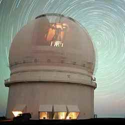
CFHT Observatory. Image credit: CFHT Click to enlarge
The genius of Albert Einstein, who added a “cosmological constant” to his equation for the expansion of the universe but later retracted it, may be vindicated by new research.
The enigmatic dark energy that drives the accelerating expansion of the universe behaves just like Einstein’s famed cosmological constant, according to the Supernova Legacy Survey (SNLS), an international team of researchers in France and Canada that collaborated with large telescope observers at Oxford, Caltech and Berkeley. Their observations reveal that the dark energy behaves like Einstein’s cosmological constant to a precision of 10 per cent.
“The significance is huge,” said Professor Ray Carlberg of the Department of Astronomy and Astrophysics at U of T. “Our observation is at odds with a number of theoretical ideas about the nature of dark energy that predict that it should change as the universe expands, and as far as we can see, it doesn’t.” The results will be published in an upcoming issue of the journal Astronomy & Astrophysics.
“The Supernova Legacy Survey is arguably the world leader in our quest to understand the nature of dark energy,” said study co-author Chris Pritchet, a professor of physics and astronomy at the University of Victoria in British Columbia, Canada.
The researchers made their discovery using an innovative, 340-million pixel camera called MegaCam, built by the Canada-France-Hawaii Telescope and the French atomic energy agency, Commissariat ? l’?nergie Atomique. “Because of its wide field of view ? you can fit four moons in an image ? it allows us to measure simultaneously, and very precisely, several supernovae, which are rare events,” said Pierre Astier, one of the scientists with the Centre National de la Recherche Scientifique (CNRS) in France.
“Improved observations of distant supernovae are the most immediate way in which we can learn more about the mysterious dark energy,” adds Richard Ellis, a professor of astronomy at the California Institute of Technology. “This study is a very big step forward in quantity and quality.”
Study co-author Saul Perlmutter, a physics professor at the University of California, Berkeley, says the findings kick off a dramatic new generation of cosmology work using supernovae. “The data is more beautiful than we could have imagined 10 years ago ? a real tribute to the instrument builders, the analysis teams and the large scientific vision of the Canadian and French science communities.”
The SNLS is a collaborative international effort that uses images from the Canada-France-Hawaii Telescope, a 3.6-metre telescope atop Mauna Kea, a dormant Hawaiian volcano. The current results are based on about 20 nights of data, the first of over nearly 200 nights of observing time for this project. The researchers identify the few dozen bright pixels in the 340 million captured by MegaCam to find distant supernovae, then acquire their spectra using some of the largest telescopes on earth?the Frederick C. Gillett Gemini North Telescope on Mauna Kea, the Gemini South Telescope on the Cerro Pach?n mountain in the Chilean Andes, the European Southern Observatory Very Large Telescopes (VLT) at the Paranal Observatory in Atacama, Chile, and the Keck telescopes on Mauna Kea. The SNLS is one component of a massive 500-night program of imaging being undertaken as the CFHT Legacy Survey.
“Only the world’s largest optical telescopes ? those from eight to 10 metres in diameter ? are capable of studying distant supernovae in detail by examining the spectrum,” said Isobel Hook, an astronomer in the Department of Astrophysics at Oxford University.
The current paper is based on about one-tenth of the imaging data that will be obtained by the end of the survey. Future results are expected to double or even triple the precision of these findings and conclusively solve several remaining mysteries about the nature of dark energy.
The research was funded by the Canada-France-Hawaii Telescope, the Commissariat ? l’?nergie Atomique (CEA), Centre National de la Recherche Scientifique, Institut National des Sciences de l’Univers du CNRS, the Natural Sciences and Engineering Research Council of Canada, the National Research Council of Canada’s Herzberg Institute of Astrophysics, the Gemini Observatory, the Particle Physics and Astronomy Research Council, the W. M. Keck Observatory and the European Southern Observatory.
Original Source: U of T News Release
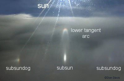
Subhorizon halos. Image credit: Don Davis. Click to enlarge
Thanksgiving is the biggest travel holiday of the year in the United States. Millions of people board airplanes and fly long hours to visit friends and family.
Do you dread the trip? Think of it as a sky watching opportunity. There are some things you can see only through the window of an airplane. Atmospheric optics expert Les Cowley lists a few of his favorites:
“Both sides of the aircraft have their own sights,” says Cowley. “On the side opposite the sun, the main thing to look for is the glory. Clouds below the aircraft are required. They are the canvas on which the glory is ‘painted.'”
“Look toward the antisolar point, the place in the clouds directly opposite the sun,” he instructs. “There, if the aircraft is low enough, you will find the shadow of the plane. Surrounding the shadow is the glory–a bright white glow surrounded by one or more shimmering rings of color.”
“These rings are formed when light is scattered backwards by individual water droplets in the cloud. The more uniform the size of the cloud droplets, the more rings you will see. They swell and contract as you travel over clouds with smaller or larger droplets.”
No clouds beneath you?
“In that case,” says Cowley, “another optical effect might be visible, especially over arid regions or pine forests. This is the opposition effect, a bright patch of light moving along the ground below you. The brightening, which is always directly opposite the sun, marks the point where the shadows of objects, like trees or soil granules, are hidden beneath those objects. The area consequently looks brighter, and slightly more yellow, than the surroundings.” (Click here to view an image of the opposition effect, photographed by Eva Seidenfaden flying over Uzbekstan.)
Turning to the sunward side of the aircraft…
“That is the realm of ice halos,” says Cowley. Ice halos are rings and arcs of light caused by ice crystals in high clouds. “They are often rainbow-colored,” he notes, “but they are not rainbows.”
From the ground you look up to see these halos. From an airplane you look down.
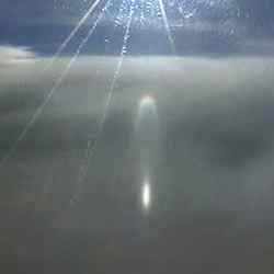
“You might be able to see subhorizon halos invisible from low ground,” says Cowley. “The brightest, sometimes blindingly bright, is the subsun. This is a direct reflection of the sun from millions of flat plate-shaped ice crystals floating in the clouds beneath you and acting together as a giant mirror. As the aircraft moves the subsun drifts along the clouds, sometimes growing, sometimes contracting, sometimes wobbling as crystals with different tilts are sampled. Sometimes a column of light will extend upward from the subsun toward the real sun–this is a lower sun pillar.”
“Sunrise and sunset from high altitudes are special,” Cowley adds. “The speed of the aircraft can make them faster or slower than usual. Furthermore, the sun is extra-flattened because its light is refracted almost twice the normal amount by its passage into the dense lower atmosphere and then out again to you. On a night flight, you might catch the moonrise; its distortions and flattening are greater for the same reason.”
“And if none of these things are visible on your particular flight, ignore fellow passengers and crane your head to see some of the sky above you. It is dark and a deep violet blue–darker than you will ever see on the ground. A large part of Earth’s atmosphere is beneath and there are far fewer molecules to scatter the sun’s light and turn the sky blue. You are not far from space.”
Happy Thanksgiving!
Original Source: NASA News Release
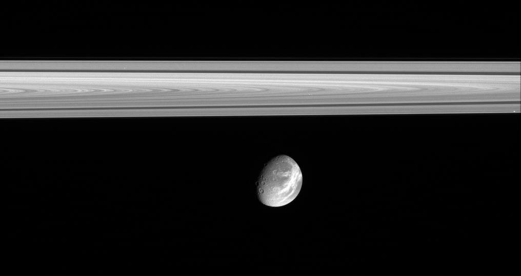
Saturn’s moon Dione. Image credit: NASA/JPL/SSI Click to enlarge
The soft appearance of Dione’s wispy terrains belies their true nature. They are, in fact, complex systems of crisp, braided fractures that cover the moon’s trailing hemisphere.
(See Dione’s Surprise for a closer view of the fractures.)
This view shows the western potion of the wispy terrain on Dione (1,126 kilometers, or 700 miles across). The craters Dido and Antenor can be seen near the terminator at lower left. In the rings above, the dark Cassini Division between the A and B rings is visible.
The image was taken in visible light with the Cassini narrow-angle camera on Oct. 9, 2005, at a distance of approximately 1.8 million kilometers (1.1 million miles) from Dione and at a Sun-Dione-spacecraft, or phase, angle of 52 degrees. The image scale is 11 kilometers (7 miles) per pixel.
The Cassini-Huygens mission is a cooperative project of NASA, the European Space Agency and the Italian Space Agency. The Jet Propulsion Laboratory, a division of the California Institute of Technology in Pasadena, manages the mission for NASA’s Science Mission Directorate, Washington, D.C.
The Cassini orbiter and its two onboard cameras were designed, developed and assembled at JPL. The imaging operations center is based at the Space Science Institute in Boulder, Colo. For more information about the Cassini-Huygens mission visit http://saturn.jpl.nasa.gov . The Cassini imaging team homepage is at http://ciclops.org .
Original Source: NASA/JPL/SSI News Release