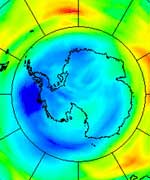
Atlas Launches Secret Payload

An Atlas IIAS rocket lifted off tonight, successfully carrying a national security payload into orbit.

The mission, called AC-167, was provided for the National Reconnaissance Office (NRO) by International Launch Services (ILS), using a Lockheed Martin-built Atlas vehicle. Liftoff was at 7:17 p.m. Tuesday EDT (23:17 today GMT) from Cape Canaveral?s Pad 36A, with payload separation into transfer orbit 73 minutes later.

Tonight?s flight was the eighth mission of the year for ILS, as well as the fifth Atlas launch. It also was the 73rd consecutive successful flight for the Atlas family in any launch configuration. This also marks the 30th and final flight for an Atlas IIAS model and the 63rd flight and final flight of any Atlas II version. In addition, this was the final flight after 47 years of the Rocketdyne MA-5A engine, which powered the Atlas II booster.

?The Atlas family has launched government payloads for more than 40 years,? said ILS President Mark Albrecht. ?We?re always proud to have a role in assisting in the security of our nation.?

Albrecht also pointed out the perfect record of not only the Atlas IIAS vehicles, but of the entire Atlas II line, which began flying in December 1991. ?This is an awesome accomplishment, being the only U.S. expendable launch vehicle series to have had 100 percent success throughout its entire lifespan,? he said. ?The Atlas team is an incredible group of people who make Mission Success for our customers a way of life.?

This is the second ILS launch this month, following the Aug. 5 successful flight of a Proton Breeze M vehicle, with the Amazonas satellite for Hispasat of Spain and Hispamar of Brazil.

ILS is a joint venture of Atlas builder Lockheed Martin and the Proton?s builder, Khrunichev State Research and Production Space Center of Russia. ILS is headquartered in McLean, Va., a suburb of Washington, D.C.

ILS has established itself as the indisputable launch services leader by offering the industry’s two best launch systems: Atlas and Proton. With a remarkable launch rate of 66 missions since 2000, the Atlas and Proton launch vehicles have consistently demonstrated the reliability and flexibility that have made them the vehicles of choice. Since the beginning of 2003, ILS has signed more new commercial contracts than all its competitors combined. For more information and highlights of the mission, visit www.ilslaunch.com.

Original Source: ILS News Release

Arriving This Week: The Ozone Hole

Image credit: ESA
The smudges of dark blue on this Envisat-derived ozone forecast trace the start of what has unfortunately become an annual event: the opening of the ozone hole above the South Pole.

“Ever since this phenomenon was first discovered in the mid-1980s, satellites have served as an important means of monitoring it,” explained Jos? Achache, ESA Director of Earth Observation Programmes. “ESA satellites have been routinely observing stratospheric ozone concentrations for the last decade.

“And because Envisat’s observations are assimilated into atmospheric models, they actually serve as the basis of an operational ozone forecasting service. These models predict the ozone hole is in the process of opening this week.”

Envisat data show 2004’s ozone hole is appearing about two weeks later than last year’s, but at a similar time period to the average during the last decade. The precise time and range of Antarctic ozone hole occurrences are determined by regional meteorological variations.

The ozone hole typically persists until November or December, when increasing regional temperatures cause the winds surrounding the South Pole to weaken, and ozone-poor air inside the vortex is mixed with ozone-rich air outside it.

The ozone hole of 2002 was an exception to this general pattern, when a late September slowdown of the polar vortex caused the ozone hole to split in two and dissipate early. Envisat’s predecessor mission, ERS-2, monitored the process.

“Envisat carries an instrument called the Scanning Imaging Absorption Spectrometer for Atmospheric Cartography (SCIAMACHY), based on a previous instrument flown aboard ERS-2, called the Global Ozone Monitoring Experiment (GOME),” said Henk Eskes of the Royal Netherlands Meteorological Institute (KNMI). “The two instruments give us a combined data set that stretches over ten years, one that Envisat adds to every day with fresh observations.

“This data set presents a very good means of eventually identifying long-term trends in ozone. Whether or not the ozone layer is starting to recover is a hotly debated topic at the moment.”

The stratospheric ozone layer protects life on Earth from harmful ultraviolet (UV) radiation. The ozone thinning represented here is ultimately caused by the presence of man-made pollutants in the atmosphere such as chlorine, originating from man-made pollutants like chlorofluorocarbons (CFCs).

Now banned under the Montreal Protocol, CFCs were once widely used in aerosol cans and refrigerators. CFCs themselves are inert, but ultraviolet radiation high in the atmosphere breaks them down into their constituent parts, which can be highly reactive with ozone.

Just because they were banned does not mean these long-lived chemicals have vanished from the air, so scientists expect the annual South Polar ozone hole to continue to appear for many years to come.

During the southern hemisphere winter, the atmospheric mass above the Antarctic continent is kept cut off from exchanges with mid-latitude air by prevailing winds known as the polar vortex. This leads to very low temperatures, and in the cold and continuous darkness of this season, polar stratospheric clouds are formed that contain chlorine.

As the polar spring arrives, the combination of returning sunlight and the presence of polar stratospheric clouds leads to splitting of chlorine into highly ozone-reactive radicals that break ozone down into individual oxygen molecules. A single molecule of chlorine has the potential to break down thousands of molecules of ozone.

ESA’s ten-instrument Envisat spacecraft carries three instruments to measure the atmosphere; the results here come from SCIAMACHY, which provides global coverage of the distribution of ozone and other trace gases, as well as aerosols and clouds.

KNMI processes SCIAMACHY data in near-real time as the basis of an operational ozone forecasting service. This is part of a suite of atmospheric information services provided by a project called TEMIS (Tropospheric Emission Monitoring Internet Service) that also includes UV radiation monitoring and forecasting.

TEMIS is backed by ESA as part of the Agency’s Data User Programme, intended to establish viable Earth Observation-based services for communities of users.

The TEMIS atmospheric ozone forecast seen here has atmospheric ozone measured in Dobson Units (DUs), which stands for the total thickness of ozone in a given vertical column if it were concentrated into a single slab at standard temperature and atmospheric pressure ? 400 DUs is equivalent to a thickness of four millimetres, for example.

Envisat results to be revealed
Launched in March 2002, ESA’s Envisat satellite is an extremely powerful means of monitoring the state of our world and the impact of human activities upon it. Envisat carries ten sophisticated optical and radar instruments to observe and monitor the Earth’s atmosphere, land, oceans and ice caps, maintaining continuity with the Agency’s ERS missions started in 1991.

After two and a half years in orbit, more than 700 scientists from 50 countries are about to meet at a special symposium in Salzburg in Austria to review and discuss early results from the satellites, and present their own research activities based on Envisat data.

Starting next Monday, the Envisat Symposium will address almost all fields of Earth science, including atmospheric chemistry, coastal studies, radar and interferometry, winds and waves, vegetation and agriculture, landslides, natural risks, air pollution, ocean colour, oil spills and ice.

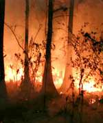
There are over 650 being presented at the Symposium, selected by peer review. Presentations will include results on the Prestige oil spill, last year’s forest fires in Portugal, the Elbe flooding in 2002, the evolution of the Antarctic ozone hole, the Bam earthquake and pollution in Europe.

Numerous demonstrations are planned during the week in the ESA Exhibit area. An industrial consortium exhibit on the joint ESA-European Commission Global Monitoring for Environment and Security (GMES) initiative is also planned.

Original Source: ESA News Release

Astronomer Fred Whipple Dies

Dr. Fred Lawrence Whipple, the oldest living American astronomer and one of the last giants of 20th century astronomy, passed away yesterday at the age of 97 following a prolonged illness. He was Phillips Professor of Astronomy Emeritus at Harvard University and a Senior Physicist at SAO.

“Fred Whipple was one of those rare individuals who affected our lives in many ways. He predicted the coming age of satellites, he revolutionized the study of comets and as Director of the Smithsonian Astrophysical Observatory, he helped form the Harvard-Smithsonian Center for Astrophysics,” says Charles Alcock, current Director of the Harvard-Smithsonian Center for Astrophysics (CfA).

A discoverer of six comets, Whipple may be best known for his comet research. Five decades ago, he first suggested that comets were “icy conglomerates,” what the press called “dirty snowballs.” His dirty snowball theory caught the imagination of the public even as it revolutionized comet science.

Whipple’s change of concept from the generally accepted “flying sandbank” model was “one of the most important contributions to solar system studies in the 20th century,” says Dr. Brian Marsden, director of the Minor Planet Center located at SAO. “I think many people would agree that that was a really shining moment in his scientific career.” A 2003 survey by The Astrophysical Journal showed that Whipple’s 1950 and 1951 scientific papers on the “icy conglomerate” model were the most cited papers in past 50 years.

Whipple’s comet work continued for a lifetime. In 1999, he was named to work on NASA’s Contour mission, becoming the oldest researcher ever to accept such a post.

Never one to limit his work to one area of research, Whipple also contributed to more earthly challenges. During World War II, Whipple co-invented a cutting device that converted lumps of tinfoil into thousands of fragments known as chaff. Allied aircraft would release chaff to confuse enemy radar. Whipple was particularly proud of this invention, for which President Truman awarded him a Certificate of Merit in 1948.

Whipple also strongly influenced the early era of spaceflight. Mindful of the damage to spacecraft from meteors, in 1946 he invented the Meteor Bumper, a thin outer skin of metal. Also known as the Whipple Shield, this mechanism explodes a meteor on contact, preventing the spacecraft from receiving catastrophic damage. Improved versions of it are still in use today.

Whipple and a handful of other scientists had the foresight to envision the era of artificial satellites. Only Whipple had both the imagination and the managerial skill to organize a worldwide network of amateur astronomers to track these then hypothetical objects and to determine their orbits. When Sputnik I was successfully launched on 4 October 1957, Whipple’s group was the only one prepared. Cambridge fast became a nerve center of the earliest part of the space age. Whipple and some of his staff were even featured on the cover of Life magazine for their satellite tracking prowess.

Later, also under his leadership, SAO developed an optical tracking system for satellites using a network of Baker-Nunn cameras. That network achieved spectacular success. “It tracked satellites so well that astronomers were able to determine the exact shape of the Earth from its gravitational effects on satellite orbits,” says Dr. Myron Lecar of SAO.

For his work on the network, Whipple received from President John F. Kennedy in 1963 the Distinguished Federal Civilian Service award. “I think that was my most exciting moment, when I was able to invite my parents and my family to the Rose Garden for the award ceremony,” Whipple said in a 2001 interview.

Born in Red Oak, Iowa, on November 5, 1906, Whipple studied at Occidental College and earned his undergraduate degree in mathematics at the University of California at Los Angeles, prior to moving to Berkeley to obtain his Ph.D. degree in 1931. He then moved to Harvard College Observatory in Cambridge, Massachusetts.

Whipple directed the Smithsonian Astrophysical Observatory (SAO) from 1955 to 1973, before it joined with the Harvard College Observatory to form the Harvard-Smithsonian Center for Astrophysics (CfA).

“Fred Whipple was a truly extraordinary person among extraordinary people. He was gifted with great scientific imagination, superb analytical skills, and excellent management acumen,” says Dr. Irwin Shapiro, who served as CfA director from 1983 to 2004.

In the late 1960s, Whipple selected Mount Hopkins in southern Arizona as the site for a new SAO astronomical facility. Whipple was part of the group that initiated a novel and low-cost approach to building large telescopes first realized in the construction of the Multiple Mirror Telescope, a joint project of SAO and the University of Arizona. Mt. Hopkins Observatory was renamed Fred Lawrence Whipple Observatory in 1981.

Dr. George Field, the first CfA director, says of Whipple, “He will be remembered by a generation of scientists for his leadership and for his keen insight. He was admired by his friends and colleagues for his integrity, and for doggedly pursuing his research into his nineties.”

In 1946 Whipple married Babette F. Samelson, by whom he had two daughters, Sandra and Laura. He also had a son, Earle Raymond, by his first marriage.

Headquartered in Cambridge, Mass., the Harvard-Smithsonian Center for Astrophysics (CfA) is a joint collaboration between the Smithsonian Astrophysical Observatory and the Harvard College Observatory. CfA scientists, organized into six research divisions, study the origin, evolution and ultimate fate of the universe.

Original Source: Harvard-Smithsonian Center for Astrophysics News Release

New Class of Planets Found

Astronomers announced today the first discovery of a new class of planets beyond our solar system about 10 to 20 times the size of Earth – far smaller than any previously detected. The planets make up a new class of Neptune-sized extrasolar planets.

In addition, one of the new planets joins three others around the nearby star 55 Cancri to form the first known four-planet system.

The discoveries consist of two new planets. They were discovered by the world renowned planet-hunting team of Drs. Paul Butler and Geoffrey Marcy of the Carnegie Institute of Washington and University of California, Berkeley, respectively; and Barbara McArthur of the University of Texas, Austin. Both findings were peer- reviewed and accepted for future publication in the Astrophysical Journal. NASA and the National Science Foundation funded the research.

“NASA, along with our partner NSF, is extremely proud of this significant planetary discovery,” said Al Diaz, Associate Administrator of NASA’s Science Mission Directorate. “The outcome of the tremendous work of the project scientists is a shining example of the value of space exploration.”

“These Neptune-sized planets prove that Jupiter-sized, gas giants aren’t the only planets out there,” Marcy said. Butler added, “We are beginning to see smaller and smaller planets. Earth-like planets are the next destination.”

Future NASA planet-hunting missions, including Kepler, the Space Interferometry Mission and the Terrestrial Planet Finder, will seek such Earth-like planets. Nearly 140 extrasolar planets have been discovered.

Both of the new planets stick very close to their parent stars, whipping around them in a matter of days. The first planet, discovered by Marcy and Butler, circles a small star called Gliese 436 about every two-and-one-half days at just a small fraction of the distance between Earth and the Sun, or 4.1 million kilometers (2.6 million miles). This planet is only the second known to orbit an M dwarf, a type of low-mass star four-tenths the size of our own sun. Gliese 436 is located in our galactic backyard, 30 light-years away in the constellation Leo.

The second planet, found by McArthur, speeds around 55 Cancri in just under three days, also at a fraction of the distance between Earth and the sun, at approximately 5.6 million kilometers (3.5 million miles). Three larger planets also revolve around the star every 15, 44 and 4,520 days, respectively. Marcy and Butler discovered the outermost of these in 2002. It is still the only known Jupiter-like gas giant to reside as far away from its star as our own Jupiter. The 55 Cancri is about 5 billion years old, a bit lighter than the sun, and is located 41 light-years away in the constellation Cancer. “55 Cancri is a premier laboratory for the study of planetary system formation and evolution,” McArthur said.

Because the new planets are smaller than Jupiter, it is possible they are made of rock, or rock and ice, rather than gas. According to the scientists, the planets may have, like Earth, formed through gradual accumulation of rocky bodies. “A planet of Neptune’s size may not have enough mass to hold onto gas, but at this point we don’t know,” Butler said.

Both discoveries were made using the “radial velocity” technique, in which a planet’s gravitational tug is detected by the wobble it produces in the parent star. Butler, Marcy and collaborators, including Dr. Deborah Fischer of San Francisco State University and Dr. Steven Vogt of the University of California, Santa Cruz, discovered their “Neptune” after careful observation of 950 nearby stars with the W.M. Keck Observatory in Mauna Kea, Hawaii. They were able to spot such a relatively small planet, because the star it tugs on is small and more susceptible to wobbling.

McArthur and collaborators Drs. Michael Endl, William Cochran and Fritz Benedict of the University of Texas discovered their “Neptune” after obtaining over 100 observations of 55 Cancri from the Hobby- Eberly Telescope at McDonald Observatory in West Texas. Combining this data with past data from Marcy, Fischer and Butler from the Lick Observatory in California, and archival data from NASA’s Hubble Space Telescope, the team was able to model the orbit of 55 Cancri’s outer planet. This, in turn, allowed them to clearly see the orbits of the other three inner planets, including the new Neptune-sized one.

Original Source: NASA News Release

Station Will Get a Better View

Development phase completion of the European-built observation module, or “cupola”, for the International Space Station will be marked by a ceremony at the Alenia Spazio facility in Turin, Italy on Monday 6 September.

The cupola, currently scheduled for launch in January 2009, is an observation and control tower for the ISS, with windows that will provide a panoramic view for observing and guiding operations on the outside of the station.

The pressurised module will accommodate command and control workstations and other hardware, enabling crewmembers to control the station?s robotic arm – for attaching and assembling various station elements – and to communicate with other crewmembers in other parts of the station or outside during spacewalk activities. The cupola will also be used for observational applications in the areas of Earth observation and space science.

The cupola project is the outcome of a bilateral barter agreement between the European Space Agency and NASA, under which ESA is providing the cupola for the ISS in exchange for Shuttle transportation of European equipment and experiments to the station.

The completion of the cupola marks the end of the development phase of the project, which began with the signing of the cupola contract between ESA and Alenia Spazio on 8 February 1999. Under the contract, Alenia Spazio acted as prime contractor for production, responsible for coordinating six other firms: CASA (Spain), APCO (Switzerland), SAAB Ericsson and Lindholmen Development (Sweden), EADS Space Transportation (Germany) and Verhaert (Belgium).

The 1.8-tonne cupola is now ready to be transported to the Kennedy Space Center at Cape Canaveral, Florida. There, it will go through a final set of checks before being put into storage for four years, at the end of which it will be prepared for launch.

Original Source: ESA News Release

X-43 Receives Guinness World Record

Guinness World Records has recognized the world speed record set by NASA’s hypersonic X-43A aircraft in an experimental flight over the Pacific Ocean earlier this year. The unpiloted, 12- foot-long aircraft achieved Mach 6.83 — almost seven times the speed of sound — or nearly 5,000 mph, while its supersonic-combustion ramjet (scramjet) engine propelled the craft for 11 seconds during the flight on March 27.

The accomplishment will be included in the 2006 Guinness World Records book, set for release this time next year, as follows:

“On 27 March 2004, NASA’s unmanned Hyper-X (X-43A) airplane reached Mach 6.83, almost seven times the speed of sound. The X-43A was boosted to an altitude of 29,000 m (95,000 ft) by a Pegasus rocket launched from beneath a B52-B aircraft. The revolutionary ‘scramjet’ aircraft then burned its engine for around 11 seconds during flight over the Pacific Ocean.”

If NASA researchers have their way, the record won’t stand long. The final flight in the Hyper-X program is scheduled to take place in October, when another X-43A aircraft will attempt to fly at Mach 10 — ten times the speed of sound — or 7,200 mph.

The flight was part of NASA’s Hyper-X program, designed to demonstrate advanced high-speed propulsion system concepts to overcome one of the greatest aeronautical research challenges – air-breathing hypersonic flight. The advantage of air-breathing flight is that the vehicle — whether it is aircraft or spacecraft ?scoops the air its engines need from the atmosphere rather than carrying heavy, bulky tanks, as rockets do.

The challenge is to introduce fuel, ignite it and produce positive thrust while highly compressed air rushes through the engine in mere milliseconds — roughly analogous to lighting a match and keeping it burning in a hurricane-force wind.

Compared to rocket-powered vehicles like the Space Shuttle, scramjets promise more airplane-like operations for increased affordability, flexibility and safety for ultra high-speed flights within the atmosphere and into Earth orbit.

The X-43A flight easily set a world speed record for an air-breathing engine aircraft. The previous known record was held by a ramjet-powered missile, which achieved slightly more than Mach 5. A ramjet operates by subsonic combustion of fuel in a stream of air compressed by the forward speed of the aircraft itself, as opposed to a normal jet engine, in which the compressor section (the fan blades) compresses the air. A scramjet (supersonic-combustion ramjet) is a ramjet engine in which the airflow through the whole engine remains supersonic.

The highest speed attained by a rocket-powered airplane, NASA’s X-15 aircraft, was Mach 6.7.The fastest air-breathing, manned vehicle, the SR-71, achieved slightly more than Mach 3.2. The X-43A more than doubled the top speed of the jet-powered SR-71.

Guinness World Records? science editor David Hawksett has already expressed a n interest in attending the fall flight.

“Operating an atmospheric vehicle at almost Mach 7 is impressive enough, but to be able to use oxygen from the air, instead of a fuel tank, as it screams into the engine intakes at 5,000 mph is a mind-boggling technical achievement. It?s wonderful to see scramjet technology finally begin to take off,” said Hawksett.

The Hyper-X program is conducted by NASA’s Aeronautics Research Mission Directorate with the NASA Langley Research Center, Hampton, Va., as lead center with responsibility for hypersonic technology development and the NASA Dryden Flight Research Center, Edwards, Calif., responsible for flight research and testing.

Guinness World Records issued a certificate to NASA documenting the X-43A accomplishment, and will feature the story on its web site: http://www.guinnessworldrecords.com/

For more information on NASA’s Aeronautics Research Mission Directorate programs, including Hyper-X, on the Internet, visit: http://www.aeronautics.nasa.gov/

Original Source: NASA News Release

Here’s an article about the biggest airplane in the world.

Plankton’s Glow Seen from Space

For the first time, scientists may now detect a phytoplankton bloom in its early stages by looking at its red “glow” under sunlight, due to the unique data from two NASA satellites. According to a study conducted in the Gulf of Mexico, this phenomenon can forewarn fishermen and swimmers about developing cases of red tides that occur within plumes of dark-colored runoff from river and wetlands, sometimes causing “black water” events.

Dark-colored river runoff includes nitrogen and phosphorus, which are used as fertilizers in agriculture. These nutrients cause blooms of marine algae called phytoplankton. During extremely large phytoplankton blooms where the algae is so concentrated the water may appear black, some phytoplankton die, sink to the ocean bottom and are eaten by bacteria. The bacteria consume the algae and deplete oxygen from the water that leads to fish kills.

Chuanmin Hu and Frank Muller-Karger, oceanographers at the College of Marine Science of University of South Florida, St. Petersburg, Fla., used fluorescence data from NASA’s Moderate Resolution Imaging Spectroradiometer (MODIS) instruments aboard both NASA’s Terra and Aqua satellites. MODIS detects the glow or phytoplankton fluorescence, from the plant’s chlorophyll. The human eye cannot detect the red fluorescence.

The ability to detect glowing areas of water helps researchers identify whether phytoplankton are present in large dark water patches that form off the coast of Florida. Without these data, it is impossible to differentiate phytoplankton blooms from plumes of dark river runoff that contain few individual phytoplankton cells.

Because colored dissolved organic matter that originates in rivers can absorb similar amounts of blue and green color signals as plants do, traditional satellites that simply measure ocean color cannot distinguish phytoplankton blooms within such patches.

Although satellites cannot directly measure nutrients in lakes, rivers, wetlands and oceans, remote sensing technology measure the quantities of plankton. Scientists can then calculate how much nutrient might be needed to grow those amounts of plankton.

Hu and others used this technique to study the nature and origin of a dark plume event in the fall of 2003 near Charlotte Harbor, off the south Florida coast. Moderate concentrations of one of Florida’s red tide species, were found from water samples.

“Our study traces the black water patches near the Florida Keys to some 200 kilometers (124 miles) away upstream,” said Hu. “These results suggest that the delicate Florida Keys ecosystem is connected to what happens on land and in two remote rivers, the Peace and Caloosahatchee, as they drain into the ocean. Extreme climate conditions, such as abnormally high rainfall in spring and summer 2003, may accelerate such connections,” he added.

These findings are based on scientific analyses of several things. Data used include satellite ocean color from MODIS and Sea-viewing Wide Field-of-view Sensor (SeaWiFS), and wind data from NASA’s QuikSCAT satellite. U.S. Geological Survey, National Oceanic and Atmospheric Administration (NOAA), Florida?s Fish and Wildlife Research Institute, and other organizations provided rain, river discharge, and field survey information.

By knowing which way the winds blow and the currents flow, Hu and colleagues can predict where black water may move.

Red tides occur every year off Florida and are known to cause fish kills, coral stress and mortality, and skin and respiratory problems in humans. Previous studies show that prolonged “black water” patches cause water quality degradation and may cause coral death. The use of remote sensing satellites provides effective means for monitoring and predicting such events.

The link between coastal runoff and black water events is an example of how land and ocean ecosystems are linked together. “Coastal and land managers over large areas need to work together, to alleviate more black water events from taking place in the future,” said Muller-Karger.

This study appeared in a recent issue of the American Geophysical Union’s Geophysical Research Letters. Coauthors of the article include Gabriel Vargo and Merrie Beth Neely from University of South Florida and Elizabeth Johns from NOAA’s Atlantic Oceanographic and Meteorological Laboratory.

NASA’s Science Directorate works to improve the lives of all humans through the exploration and study of Earth’s system, the solar system and the Universe.

Original Source: NASA News Release

What Impact Would Set the World on Fire?

Image credit: Josh O?Conner and wildlandfire.com
Scientists conclude that, 65 million years ago, a 10-kilometer-wide asteroid or comet slammed into what is now the Yucat?n peninsula, excavating the Chicxulub impact crater and setting into motion a chain of catastrophic events thought to precipitate the extinction of the dinosaurs and 75 percent of animal and plant life that existed in the late Cretaceous period.

“The impact of an asteroid or comet several kilometers across heaps environmental insult after insult on the world,” said Dr. Daniel Durda, a senior research scientist at Southwest Research Institute? (SwRI?). “One aspect of the devastation wrought by large impacts is the potential for global wildfires ignited by material ejected from the crater reentering the atmosphere in the hours after the impact.”

Large impacts can blast thousands of cubic kilometers of vaporized impactor and target sediments into the atmosphere and above, expanding into space and enveloping the entire planet. These high-energy, vapor-rich materials reenter the atmosphere and heat up air temperatures to the point that vegetation on the ground below can spontaneously burst into flame.

“In 2002, we investigated the Chicxulub impact event to examine the extent and distribution of fires it caused,” said Durda. This cosmic collision carved out a crater some 40 kilometers (25 miles) deep and 180 kilometers (112 miles) across at the boundary between two geologic periods, the Cretaceous, when the dinosaurs ruled the planet, and the Tertiary, when mammals took supremacy.

“We noted that fires appeared to be global, covering multiple continents, but did not cover the entire Earth,” Durda continued. “That suggested to us that the Chicxulub impact was probably near the threshold size event necessary for igniting global fires, and prompted us to ask ‘What scale of impact is necessary for igniting widespread fires?'”

In a new study, Durda and Dr. David Kring, an associate professor at the University of Arizona Lunar and Planetary Laboratory, published a theory for the ignition threshold for impact-generated fires in the August 20, 2004, issue of the Journal of Geophysical Research. Their research indicates that impacts resulting in craters at least 85 kilometers wide can produce continental-scale fires, while impact craters more than 135 kilometers wide are needed to cause global-scale fires.

To calculate the threshold size impact required for global ignition of various types of vegetation, Durda and Kring used two separate, but linked, numerical codes to calculate the global distribution of debris reentering the atmosphere and the kinetic energy deposited in the atmosphere by the material. The distribution of fires depends on projectile trajectories, the position of the impact relative to the geographic distribution of forested continents and the mass of crater and projectile debris ejected into the atmosphere.

They also examined the threshold temperatures and durations required to spontaneously ignite green wood, to ignite wood in the presence of an ignition source (such as lightning, which would be prevalent in the dust-laden energetic skies following an impact event) and to ignite rotting wood, leaves and other common forest litter.

“The Chicxulub impact event may have been the only known impact event to have caused wildfires around the globe,” Kring noted. “The Manicouagan (Canada) and Popigai (Russia) impact events, however, may have caused continental-scale fires. The Manicouagan impact occurred in the late Triassic, and the Popigai impact event occurred in the late Eocene, but neither has been firmly linked yet to the mass extinction events that occurred at those times.”

Kring is currently at the International Geological Congress in Florence, Italy, giving a keynote address on the Chicxulub impact event and its relationship to the mass extinctions at the Cretaceous-Tertiary boundary period. Durda is available for comment at the SwRI offices in Boulder, Colo.

Original Source: SWRI News Release

Mars Express View of Eos Chasma

This image, taken by the High Resolution Stereo Camera (HRSC) on board ESA’s Mars Express spacecraft, shows the southern part of Valles Marineris, called Eos Chasma.

The images was taken during orbit 533 in June 2004, and is centred at Mars longitude 322? East and latitude 11? South. The image resolution is approximately 80 metres per pixel.

Between surrounding plains and the smooth valley floor, a height difference of about 5000 metres has been measured.

The plain to the south, above Eos Chasma, is covered by several impact craters with diameters of around 20 kilometres and drainage channels.

To the east on this plain, isolated regions with cracked surfaces become more prominent. The direction of flow of the drainage channels in this area of the plain is ambiguous, as the channels to the north-east drain towards the south-east, and those in the south-west normally flow to the north-west.

The northern part of Eos Chasma?s valley floor is a rough area with angular hills reaching almost 1000 metres. In contrast, the southern part reveals a smooth topography with distinct flow structures.

In some areas of the southern slope, at least two terrace levels can be observed. Some haze in the valley hints at the presence of aerosols (airborne microscopic dust or liquid droplets).

Original Source: ESA News Release

Wallpaper: Hurricane Frances

This photo of Hurricane Frances was taken by Astronaut Mike Fincke aboard the International Space Station as he flew 230 statute miles above the storm at about 9 a.m. CDT Friday, Aug. 27, 2004. At the time, Frances was located 820 miles east of the Lesser Antilles in the Atlantic Ocean, moving west-northwest at 10 miles per hour, with maximum sustained winds of 105 miles per hour. Fincke, the NASA ISS Science Officer and Flight Engineer, and Expedition 9 Commander Gennady Padalka are in the fifth month of a six-month flight aboard the Station.

Original Source: NASA News Release