How Deforestation in Brazil is Affecting Local Climate

Image credit: NASA
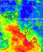
NASA satellite data are giving scientists insight into how large-scale deforestation in the Amazon Basin in South America is affecting regional climate. Researchers found during the Amazon dry season last August, there was a distinct pattern of higher rainfall and warmer temperatures over deforested regions.

Researchers analyzed multiple years of data from NASA’s Tropical Rainfall Measuring Mission (TRMM). They also used data from the Department of Defense Special Sensor Microwave Imager and the National Oceanic and Atmospheric Administration’s Geostationary Operational Environmental Satellites.

The study appeared in a recent issue of the American Meteorological Society’s Journal of Climate. Lead authors, Andrew Negri and Robert Adler, are research meteorologists at NASA’s Goddard Space Flight Center (GSFC), Greenbelt, Md. Other authors include Liming Xu, formerly of the University of Arizona, Tucson, and Jason Surratt, North Carolina State University, Raleigh.

“In deforested areas, the land heats up faster and reaches a higher temperature, leading to localized upward motions that enhance the formation of clouds and ultimately produce more rainfall,” Negri said.

The researchers caution the rainfall increases were most pronounced in August, during the transition from dry to wet seasons. In this transition period, the effects of land cover, such as evaporation, are not overwhelmed by large-scale weather disturbances that are common during the rest of the year. While the study, based on satellite data analysis, focused on climate changes in the deforested areas, large increases in cloud cover and rainfall were also observed in the naturally un-forested savanna region and surrounding the urban area of Port Velho, Brazil, particularly in August and September.

Recent studies by Dr. Marshall Shepherd cited similar findings, including an average rain-rate increase of 28 percent downwind of urban areas and associated changes in the daily timing of cloud formation and precipitation. He is also a research meteorologist at GSFC.

This research confirmed the Amazon savanna region experienced a shift in the onset of cloudiness and rainfall toward the morning hours. The shift was likely initiated by the contrast in surface heating across the deforested and savanna region.

The varied heights of plants and trees in the region change the aerodynamics of the atmosphere, creating more circulation and rising air. When the rising air reaches the dew point in the cooler, upper atmosphere, it condenses into water droplets and forms clouds.

Negri acknowledged other factors are involved. The savanna in this study is approximately 100 kilometers (62 miles) wide, the perfect size to influence precipitation, such as rain showers and thunderstorms. Earlier studies hypothesized certain land surfaces, such as bands of vegetation 50 to 100 kilometers (31-62 miles) wide in semiarid regions, could result in enhanced precipitation.

This research is in agreement with the recent and sophisticated computer models developed by the Massachusetts Institute of Technology. The models concluded small-scale circulations, including the mixing and rising of air induced by local land surfaces, could enhance cloudiness and rainfall. Many earlier studies that relied on models developed in the 1990s or earlier concluded widespread deforestation of the Amazon Basin would lead to decreased rainfall.

“The effects here are rather subtle and appear to be limited to the dry season. The overall effect of this deforestation on annual and daily rainfall cycles is probably small and requires more study,” Negri said. Future research will use numerical models for investigating the linkage between deforested land surface and the cloud-precipitation components of the water cycle.

NASA’s Earth Science Enterprise is dedicated to understanding the Earth as an integrated system and applying Earth System Science to improve prediction of climate, weather, and natural hazards using the unique vantage point of space.

Original Source: NASA News Release

Opportunity Checks the Edge of the Crater

Image credit: NASA/JPL
NASA’s Mars Opportunity rover began its latest adventure today inside the martian crater informally called Endurance. Opportunity will roll in with all six wheels, then back out to the rim to check traction by looking at its own track marks.

“We’re going in, but we’re doing it cautiously,” said Jim Erickson, deputy project manager for the Mars Exploration Rovers at NASA’s Jet Propulsion Laboratory, Pasadena, Calif. Barring any surprises, Opportunity will enter the stadium-sized crater Wednesday for two to three weeks of scientific studies.

“NASA has made a careful decision. The potential science benefits of sending Opportunity into the crater are well worth the calculated risk the rover might not be able to climb back out,” said JPL’s Dr. Firouz Naderi, manager of NASA’s Mars Exploration Program. “Inside the Endurance crater waits the possibility for the most compelling science investigations Opportunity could add to what it has already accomplished. We have done the ground testing necessary to evaluate the likelihood of exiting the crater afterwards.”

“Spirit and Opportunity are well into their bonus periods after successfully completing their three-month primary missions in April,” Naderi said. “Both rovers are starting new chapters. Spirit is within a stone’s throw of Columbia Hills, and Opportunity is entering the crater.”

Dr. Steve Squyres of Cornell University, Ithaca, N.Y., the rovers’ principal investigator, said, “We expect the science return of going a short way into Endurance to be very high.” The target for inspection within the crater is an exposure of rock layers beneath a layer that corresponds to rocks Opportunity previously examined in the shallower Eagle crater, where the rover landed in January.

The sulfur-rich layer seen in Eagle yielded evidence that a body of gently flowing water once covered the area. The underlying rock layers come from an earlier period. Opportunity’s observations from the rim of Endurance already have shown their composition differs from the Eagle crater’s layers.

“If there was a change in rock type, there was a change in environment,” Squyres said. “This unit will tell us what came before the salty water environment the Eagle crater unit told us about. We want to get to the contact between the two units to see how the environment changed. Is it gradual? Is it abrupt?” Even if the lower layers formed under dry conditions, they may have been exposed to water later. The water’s effect on them could have left telltale evidence of that interaction.”

One section of the target outcrop is only five to seven meters (16 to 23 feet) from the crater rim in an area dubbed Karatepe. The rover team’s plan is to get there, examine the rocks for several days, and then exit the crater. Reaching lower-priority targets, like at the bottom of the crater, would entail driving on sand, with a higher risk of not getting out again.

The strategy for driving on the crater’s inner slope is to keep wheels on rock surfaces instead of sand, said JPL rover-mobility engineer Randy Lindemann. The team ran trials with a test rover on a surface specifically built to simulate Karatepe’s surface conditions. “The tests indicate we have a substantial margin of safety for going up a rocky slope of 25 degrees,” Lindemann said. Opportunity’s observations from the rim at the top of the planned entry route show a slope of less than 20 degrees.

Spirit, launched one year ago Thursday, has driven more than 3.2 kilometers (2 miles) inside the Gusev Crater. A trench it dug in May exposed soil with relatively high levels of sulfur and magnesium, reported Dr. Johannes Brueckner, of Max-Planck-Institut fuer Chemie, Mainz, Germany. Spirit’s alpha particle X-ray spectrometer showed concentrations of these two elements varied in parallel at different locations in the trench, suggesting they may be paired as a magnesium sulfate salt.

Squyres said, “The most likely explanation is water percolated through the subsurface and dissolved out minerals. As the water evaporated near the surface, it left concentrated salts behind. I’m not talking about a standing body of water like we saw signs of at Eagle crater, but we also have an emerging story of subsurface water at Gusev,” he said.

JPL, a division of the California Institute of Technology in Pasadena, manages the Mars Exploration Rover project for NASA’s Office of Space Science, Washington, D.C.

For images and information about the Mars project on the Internet, visit http://marsrovers.jpl.nasa.gov & http://athena.cornell.edu.

Original Source: NASA/JPL News Release

Early Earth was Warm, Despite Less Energy From the Sun

Image credit: Stanford
If a time machine could take us back 4.6 billion years to the Earth’s birth, we’d see our sun shining 20 to 25 percent less brightly than today. Without an earthly greenhouse to trap the sun’s energy and warm the atmosphere, our world would be a spinning ball of ice. Life may never have evolved.

But life did evolve, so greenhouse gases must have been around to warm the Earth. Evidence from the geologic record indicates an abundance of the greenhouse gas carbon dioxide. Methane probably was present as well, but that greenhouse gas doesn’t leave enough of a geologic footprint to detect with certainty. Molecular oxygen wasn’t around, indicate rocks from the era, which contain iron carbonate instead of iron oxide. Stone fingerprints of flowing streams, liquid oceans and minerals formed from evaporation confirm that 3 billion years ago, Earth was warm enough for liquid water.

Now, the geologic record revealed in some of Earth’s oldest rocks is telling a surprising tale of collapse of that greenhouse — and its subsequent regeneration. But even more surprising, say the Stanford scientists who report these findings in the May 25 issue of the journal Geology, is the critical role that rocks played in the evolution of the early atmosphere.

“This is really the first time we’ve tried to put together a picture of how the early atmosphere, early climate and early continental evolution went hand in hand,” said Donald R. Lowe, a professor of geological and environmental science who wrote the paper with Michael M. Tice, a graduate student investigating early life. NASA’s Exobiology Program funded their work. “In the geologic past, climate and atmosphere were really profoundly influenced by development of continents.”

The record in the rocks
To piece together geologic clues about what the early atmosphere was like and how it evolved, Lowe, a field geologist, has spent virtually every summer since 1977 in South Africa or Western Australia collecting rocks that are, literally, older than the hills. Some of the Earth’s oldest rocks, they are about 3.2 to 3.5 billion years old.

“The further back you go, generally, the harder it is to find a faithful record, rocks that haven’t been twisted and squeezed and metamorphosed and otherwise altered,” Lowe says. “We’re looking back just about as far as the sedimentary record goes.”

After measuring and mapping rocks, Lowe brings samples back to Stanford to cut into sections so thin that their features can be revealed under a microscope. Collaborators participate in geochemical and isotopic analyses and computer modeling that further reveal the rocks’ histories.

The geologic record tells a story in which continents removed the greenhouse gas carbon dioxide from an early atmosphere that may have been as hot as 70 degrees Celsius (158 F). At this time the Earth was mostly ocean. It was too hot to have any polar ice caps. Lowe hypothesizes that rain combined with atmospheric carbon dioxide to make carbonic acid, which weathered jutting mountains of newly formed continental crust. Carbonic acid dissociated to form hydrogen ions, which found their way into the structures of weathering minerals, and bicarbonate, which was carried down rivers and streams to be deposited as limestone and other minerals in ocean sediments.

Over time, great slabs of oceanic crust were pulled down, or subducted, into the Earth’s mantle. The carbon that was locked into this crust was essentially lost, tied up for the 60 million years or so that it took the minerals to get recycled back to the surface or outgassed through volcanoes.

The hot early atmosphere probably contained methane too, Lowe says. As carbon dioxide levels fell due to weathering, at some point, levels of carbon dioxide and methane became about equal, he conjectures. This caused the methane to aerosolize into fine particles, creating a haze akin to that which today is present in the atmosphere of Saturn’s moon Titan. This “Titan Effect” occurred on Earth 2.7 to 2.8 billion years ago.

The Titan Effect removed methane from the atmosphere and the haze filtered out light; both caused further cooling, perhaps a temperature drop of 40 to 50 degrees Celsius. Eventually, about 3 billion years ago, the greenhouse just collapsed, Lowe and Tice theorize, and the Earth’s first glaciation may have occurred 2.9 billion years ago.

The rise after the fall
Here the rocks reveal an odd twist in the story — eventual regeneration of the greenhouse. Recall that 3 billion years ago, Earth was essentially Waterworld. There weren’t any plants or animals to affect the atmosphere. Even algae hadn’t evolved yet. Primitive photosynthetic microbes were around and may have played a role in the generation of methane and minor usage of carbon dioxide.

As long as rapid continental weathering continued, carbonate was deposited on the oceanic crust and subducted into what Lowe calls “a big storage facility … that kept most of the carbon dioxide out of the atmosphere.”

But as carbon dioxide was removed from the atmosphere and incorporated into rock, weathering slowed down — there was less carbonic acid to erode mountains and the mountains were becoming lower. But volcanoes were still spewing into the atmosphere large amounts of carbon from recycled oceanic crust.

“So eventually the carbon dioxide level climbs again,” Lowe says. “It may never return to its full glorious 70 degrees Centigrade level, but it probably climbed to make the Earth warm again.”

This summer, Lowe and Tice will collect samples that will allow them to determine the temperature of this time interval, about 2.6 to 2.7 billion years ago, to get a better idea of how hot Earth got.

New continents formed and weathered, again taking carbon dioxide out of the atmosphere. About 3 billion years ago, maybe 10 or 15 percent of the Earth’s present area in continental crust had formed. By 2.5 billion years ago, an enormous amount of new continental crust had formed — about 50 to 60 percent of the present area of continental crust. During this second cycle, weathering of the larger amount of rock caused even greater atmospheric cooling, spurring a profound glaciation about 2.3 to 2.4 billion years ago.

Over the past few million years we have been oscillating back and forth between glacial and interglacial epochs, Lowe says. We are in an interglacial period right now. It’s a transition — and scientists are still trying to understand the magnitude of global climate change caused by humans in recent history compared to that caused by natural processes over the ages.

“We’re disturbing the system at rates that greatly exceed those that have characterized climatic changes in the past,” Lowe said. “Nonetheless, virtually all of the experiments, virtually all of the variations and all of the climate changes that we’re trying to understand today have happened before. Nature’s done most of these experiments already. If we can analyze ancient climates, atmospheric compositions and the interplay among the crust, atmosphere, life and climate in the geologic past, we can take some first steps at understanding what is happening today and likely to happen tomorrow.”

Original Source: Stanford News Release

Opportunity’s Exit Strategy

Image credit: NASA/JPL
The Opportunity rover continues to cruise around the rocky rim of Endurance Crater, which is about stadium-sized in diameter. The false color image (banner) was taken by the navigation camera on May 21, 2004. This crater excavated by the impact of a tiny asteroid or a piece of a comet is about 130 meters (430 feet) wide and, from the highest point on the rim, more than 20 meters (66 feet) deep, 10 times as deep as Eagle.

An exposure of outcrop in a cliff high on the inner wall across from the rover’s current position reveals a stack of layers 5 to 10 meters (16 to 33 feet) tall. Other exposures around the inner slope of the crater may be more accessible than the cliff, and chunks from the same layers may have been thrown out onto surrounding ground by the crater-forming impact.

Team members are analyzing images like these in detail while searching for the safest route to enter and exit the steep crater. In addition to slope, good entry and exit paths are sought where stable rock predominates over loose sand which may cause slippage or loss of wheel traction. The best current candidate is a portion of Endurance called Karatepe.

In the Mars simulation environment on Earth, called the JPL sandbox or ‘Mars Yard’, mobility experts, scientists and engineers are testing the rover’s slip limits at a twenty-five degree tilt.

Inside Endurance Crater are multiple layers of exposed rocks that might provide information about a much longer period of environmental history. From the viewpoints around the rim, Opportunity’s miniature thermal emission spectrometer is returning data for mapping the mineral composition of the rocks exposed in the crater’s interior.

At Eagle Crater, an outcrop of bedrock only about the height of a street curb yielded evidence that the site was once covered by a body of salty water deep enough to splash in. “That was the last dying gasp of a body of water,” principal investigator Steve Squyres said. “The question that has intrigued us since we left Eagle Crater is what preceded that. Was there a deep body of water for a long time? Was there a shallow, short-lived playa? We don’t know.”

Although the stack of rock layers at Endurance is more than 10 times thicker than the bedrock exposure at Eagle Crater, it is still only a small fraction of the 200-meter-thick (650-foot-thick) stack seen from orbit at some other locations in Mars’ Meridian Planum region.

A close-up look at the Endurance Crater rocks could help with interpreting the other exposures seen from orbit. “It’s possible that the whole stack was deposited in water — some particles washed in by flowing water and others chemically precipitated out of the water,” said Dr. Phil Christensen of Arizona State University, Tempe, lead scientist for the rover’s spectrometer. “An alternative is that wind blew sand in.”

Brian Cooper, leader of JPL’s squad of rover drivers for Spirit and Opportunity, said the initial view of the crater doesn’t settle accessibility questions yet. “The slope right in front of us averages 18 to 20 degrees. Getting into the crater is no problem, but we have a lot more work to do to assess whether we could get back out. That depends on soil properties and slippage, as well as slope.” The planned circuit around the rim will also require careful navigation. “If you don’t go close enough to the lip, you can’t look in, but if you go too far, you could fall in,” he said. “We’re going to have a very interesting few weeks.”

When the rover tried to exit its much smaller (20 meter diameter) Eagle Crater–the mission’s initial landing site–the exit slope proved steep enough to lose wheel traction until a backup plan to maneuver through loose sand friction with six-wheel contacts.

When NASA sent astronauts to the lunar surface more than 30 years ago, it was decided not to allow them to enter craters as fresh and steep as Endurance, but Opportunity may be able to do what no human has done before on another planet.

Original Source: Astrobiology Magazine

Venus Returns, Right on Schedule

Sky watchers from around the globe had the opportunity to witness a rare transit of Venus across the surface of the Sun – an event that hasn’t happened for 122 years. Observatories and amateur astronomers made their equipment available to the public so they could watch the black disk of Venus make the transit for themselves. Most of the Americas had a poor view of the transit this time around, but they’ll have a front seat when the next one occurs in 8 years.

Resources for the Venus Transit

If you’re lucky, you’ve got a front row view of Venus as it transits across the face of the Sun. That means you’re in Europe, Africa or Asia, you’ve got the proper equipment to filter the Sun, and the weather is cooperating. If you’re like me, you lack all three. Don’t worry, though, the Internet is coming to our rescue.

Astronomers and spacecraft are going to be watching the show and broadcasting what they see in real time so anyone with an Internet connection can stay tuned as the transit progresses.

For starters, educate yourself about the transit, including safety tips and the locations of groups viewing it live. There’s great information from ASTRONET, the European Southern Observatory and NASA.

Next, tune into some spacecraft. You can see the view from SOHO, TRACE, and IMAGE. Finally, settle in with a ground-based observatory. Here’s a complete list of more than 100 observatories broadcasting from Astronet.

The show begins at 0513 UTC (aka Greenwich Mean Time). That’s the same as 1:13 am EDT or 10:13 pm PDT (June 7). The whole transit will take about 6 hours to complete.

Let me know how the transit goes for you. Did you make a special trip, or just look from your backyard? Or, like me, do you have to watch it through the Internet?

And send in your pictures, either of Venus, or of you and your friends out in the sunshine, enjoying the show. 🙂

Good luck!

Fraser Cain
Publisher
Universe Today

Gas Clouds in the Whirlpool Galaxy

Image credit: NRAO
Astronomers studying gas clouds in the famous Whirlpool Galaxy have found important clues supporting a theory that seeks to explain how the spectacular spiral arms of galaxies can persist for billions of years. The astronomers applied techniques used to study similar gas clouds in our own Milky Way to those in the spiral arms of a neighbor galaxy for the first time, and their results bolster a theory first proposed in 1964.

The Whirlpool Galaxy, about 31 million light-years distant, is a beautiful spiral in the constellation Canes Venatici. Also known as M51, it is seen nearly face-on from Earth and is familiar to amateur astronomers and has been featured in countless posters, books and magazine articles.

“This galaxy made a great target for our study of spiral arms and how star formation works along them,” said Eva Schinnerer, of the National Radio Astronomy Observatory in Socorro, NM. “It was ideal for us because it’s one of the closest face-on spirals in the sky,” she added.

Schinnerer worked with Axel Weiss of the Institute for Millimeter Radio Astronomy (IRAM) in Spain, Susanne Aalto of the Onsala Space Observatory in Sweden, and Nick Scoville of Caltech. The astronomers presented their findings to the American Astronomical Society’s meeting in Denver, Colorado.

The scientists analyzed radio emission from Carbon Monoxide (CO) molecules in giant gas clouds along M51’s spiral arms. Using telescopes at Caltech’s Owens Valley Radio Observatory and the 30-meter radio telescope of IRAM, they were able to determine the temperatures and amounts of turbulence within the clouds. Their results provide strong support for a theory that “density waves” explain how spiral arms can persist in a galaxy without winding themselves so tightly that, in effect, they disappear.

The density-wave theory, proposed by Frank Shu and C.C. Lin in 1964, says that a galaxy’s spiral pattern is a wave of higher density, or compression, that revolves around the galaxy at a speed different from that of the galaxy’s gas and stars. Schinnerer and her colleagues studied a region in one of M51’s spiral arms that presumably has just overtaken and passed through the density wave.

Their data indicate that gas on the trailing edge of the spiral arm, which has most recently passed through the density wave, is both warmer and more turbulent than gas in the forward edge of the arm, which would have passed through the density wave longer ago.

“This is what we would expect from the density-wave theory,” Schinnerer said. “The gas that passed through the density wave earlier has had time to cool and lose the turbulence caused by the passage,” she added.

“Our results show, for the first time, how the density wave operates on a cloud-cloud scale, and how it promotes and prevents star formation in spiral arms,” Aalto said.

The next step, the scientists say, is to look at other spiral galaxies to see if a similar pattern is present. That will have to wait, Schinnerer said, because the radio emission from CO molecules that provides the information on temperature and turbulence is very faint.

“When the Atacama Large Millimeter Array (ALMA) comes on line, it will have the ability to extend this type of study to other galaxies. We look forward to using ALMA to test the density-wave model more thoroughly,” Schinnerer said. ALMA is a millimeter-wave observatory that will use 64, 12-meter-diameter dish antennas on the Atacama Desert of northern Chile. Now under construction, ALMA will provide astronomers with an unprecedented capability to study the Universe at millimeter wavelengths.

The Whirlpool Galaxy was discovered by the French comet-hunter Charles Messier on October 13, 1773. He included it as object number 51 in his now-famous catalog of astronomical objects that, in a small telescope, might be mistaken for a comet. In 1845, the British astronomer Lord Rosse discovered the spiral structure in the galaxy. For amateur astronomers using telescopes in dark-sky locations, M51 is a showpiece object.

The National Radio Astronomy Observatory is a facility of the National Science Foundation, operated under cooperative agreement by Associated Universities, Inc.

Original Source: NRAO News Release

Cassini’s Orbital Entry Spot

Image credit: NASA/JPL/Space Science Institute
The path that lies ahead for the Cassini -Huygens mission is indicated in this image which illustrates where the spacecraft will be just 27 days from now, when it arrives at Saturn and crosses the ring plane 25 minutes before performing its critical orbital insertion maneuver.

The X indicates the point where Cassini will pierce the ring plane on June 30, 2004, going from south to north of the ring plane, 25 minutes before the main engine fires to begin orbital insertion. The indicated point is between the narrow F-ring on the left and Saturn?s tenuous G-ring which is too faint to be seen in this exposure.

The image was taken on May 11, 2004 when the spacecraft was 26.3 million kilometers (16.3 million miles) from Saturn. Image scale is 158 kilometers (98 miles) per pixel. Moons visible in this image: Janus (181 kilometers, 113 miles across), one of the co-orbital moons; Pandora (84 kilometers, 52 miles across), one of the F ring shepherding moons; and Enceladus (499 kilometers, 310 miles across), a moon which may be heated from within and thus have a liquid sub-surface ocean.

The Cassini-Huygens mission is a cooperative project of NASA, the European Space Agency and the Italian Space Agency. The Jet Propulsion Laboratory, a division of the California Institute of Technology in Pasadena, manages the Cassini-Huygens mission for NASA’s Office of Space Science, Washington, D.C. The imaging team is based at the Space Science Institute, Boulder, Colorado.

For more information about the Cassini-Huygens mission, visit http://saturn.jpl.nasa.gov and the Cassini imaging team home page, http://ciclops.org.

Original Source: CICLOPS News Release

Transit of Venus Starts Soon

Image credit: NASA
Want to see the 2004 Transit of Venus? Be prepared to wake up early.

On Tuesday morning, June 8th, for the first time since 1882, Venus will pass directly between Earth and the Sun. For six hours the planet’s black silhouette will crawl across the face of our star. It might be a pretty sight, or not. No one can say for sure because no one alive today has seen a transit of Venus.

If you live near the east coast of North America, you can see the crossing. The transit will be underway at dawn and visible for as much as two hours after sunrise.

Before you read the rest of this story, a reminder: Never look at the Sun without eye protection. The early morning Sun rising through the mist, reddened and dimmed by distant clouds, is so tempting; it seems safe to stare. Don’t! Even a low-hanging Sun can cause eye damage. Proper transit-watching techniques are discussed below.

The transit begins at 1:13 a.m. EDT (in the middle of the night) and ends at 7:26 a.m. EDT. If you can see the Sun before 7:26 a.m. EDT, then you can see the transit. Sky watchers east of the Mississippi River are favored. The transit will not be visible at all from Mexico, British Columbia and the following US states: Arizona, California, Colorado, Idaho, Nevada, New Mexico, Montana, Oregon, Texas, Utah, Washington, Wyoming.

A transit of Venus isn’t like a solar eclipse. The Sun won’t be blotted out or even noticeably dimmed. Venus is too small; the disk of the planet covers only 0.1% of the Sun.

Although Venus is tiny, you can probably see it without magnification. Try looking through a safe solar filter, for example, #13 or #14 welder’s glass or special “eclipse glasses” designed for solar viewing. (Do NOT use stacked sunglasses, metallized candy wrappers or compact disks; these are unsafe filters often recommended in error.) Seen through a good filter, the Sun looks like a glowing disk, about the size of the Moon, marked with a black speck–Venus.

The view is much better through a telescope. But beware: sunlight focused through a telescope can blind you instantly. There are two ways to to safely observe using a telescope:

Solar projection is one way. Align your telescope with the Sun. Do not look through the telescope or its finder scope; use shadows on the ground to effect the alignment. The shadow of a telescope looks skinniest when it is pointing directly at the Sun. Once the Sun is in the field of view, an image will shoot out of the eyepiece. Hold a white screen behind your ‘scope and, voila: a picture of the Sun. Adjust the focus of the telescope (or the distance between the eyepiece and the screen) until Venus looks crisp and round.

Solar filters are another way. Capping your telescope with a suitable sun-filter can reduce the intensity of sunlight to safe levels. Then you can look right through the eyepiece. If you’re not sure what filter is safe, contact the vendor of your telescope to ask for advice.

In addition to Venus, you’ll likely see one or two sunspots. These are planet-sized islands of magnetism floating on the Sun’s surface. Compare the two: Venus’ silhouette is dark and round like a planet. Sunspots are not so dark; and they are delightfully irregular.

A moment of special interest is “third contact” at 7:07 a.m. EDT. This is when Venus’ silhouette touches the Sun’s limb and starts its 20-minute egress from the solar disk. Third contact is the beginning of the end of the transit.

Moments before third contact, watch out for the infamous “black drop effect.” The black of space beyond the Sun’s limb will seem to reach in and touch Venus, merging with the planet to form an elongated black drop. You can recreate the black drop effect with your thumb and index finger: Hold the two in front of one eye and narrow the distance between them. Just before they touch, a shadowy bridge will spring across the gap. According to John Westfall, writing for Sky & Telescope magazine in June 2004, “this is simply the result of how two fuzzy bright-to-dark gradients add together.” The black drop effect was troublesome to 18th and 19th century astronomers who tried to measure the solar system by timing transits of Venus.

Troublesome then, fun and challenging now.

If you plan to try observing Venus on June 8th, you might want to practice on June 6th or 7th. Set up your telescope in a place where you’ll have a clear view of the Sun rising over the eastern horizon. Can you project an image of sunspots onto a wall or screen? If so, you’re ready for Venus.

And if you oversleep … mark your calendar for the next transit of Venus: June 6, 2012. Good luck!

Original Source: NASA Science Article

Opportunity Will Enter the Crater

Image credit: NASA/JPL
NASA has decided the potential science value gained by sending Opportunity into a martian impact crater likely outweighs the risk of the intrepid explorer not being able to get back out.

Opportunity has been examining the rim of stadium-sized “Endurance” crater since late May. The rover team used observations of the depression to evaluate potential science benefits of entering the crater and the traversability of its inner slopes.

The soonest Opportunity could enter Endurance is early next week. It will drive to the top of a prospective entry-and-
exit route on the southern edge of the crater and make a final check of the slope. If the route is no steeper than what recent testing runs at NASA’s Jet Propulsion Laboratory, Pasadena, Calif., suggest a rover can climb, controllers plan to radio Opportunity the command to go into the crater.

“This is a crucial and careful decision for the Mars Exploration Rovers’ extended mission,” said Dr. Edward Weiler, NASA’s Associate Administrator for Space Science. “Layered rock exposures inside Endurance Crater may add significantly to the story of a watery past environment that Opportunity has already begun telling us. The analysis just completed by the rover team shows likelihood that Opportunity will be able to drive to a diagnostic rock exposure, examine it, and then drive out of the crater. However, there’s no guarantee of getting out again, so we also considered what science opportunities outside the crater would be forfeited if the rover spends its remaining operational life inside the crater.”

At a rock outcrop in a small impact feature nicknamed, “Eagle Crater,” where Opportunity first landed, the rover found small-scale rock textures and evaporite mineral compositions testifying that a body of salty water covered the site long ago.

The wet environment may have been a suitable habitat for life, if it ever existed on Mars. However, only the uppermost layer of the region’s layered crust was exposed at Eagle Crater, not deeper layers that could reveal what the environment was like earlier.

The rock layer seen at Eagle Crater appears at Endurance Crater, too. At Endurance, though, it lies above exposures of thicker, older layers, which are the main scientific temptation for sending Opportunity inside the crater.

“Answering the question of what came before the evaporites is the most significant scientific issue we can address with Opportunity at this time,” said Dr. Steve Squyres of Cornell University, Ithaca, N.Y., principal investigator for the science instruments on both rovers. “We’ve read the last chapter, the record of the final gasps of an evaporating body of water. What came before? It could have been a deep-water environment. It could have been sand dunes. It could have been a volcano. Whatever we learn about that earlier period will help us interpret the upper layer’s evidence for a wet environment and understand how the environment changed.”

Richard Cook, project manager at JPL for the rovers, said that reaching one exposure of the older rock layers inside Endurance requires driving only about 5 to 7 meters (16 to 23 feet) into the 130-meter-diameter (140-yard-diameter) crater. The rover is on the rim at that site, which had been dubbed “Karatepe.”

“We’ll take an incremental approach, edging our way down to the target,” Cook said. The plan is to use the tools on Opportunity’s robotic arm to analyze the exposed layers for several days, then drive in reverse back up the slope and exit the crater. The slope between the rim and the layered outcrop at Karatepe is about 25 degrees.

“We have done testing that says we can do 25 degrees, provided the wheels are on a rock surface and not loose sand,” Cook said. Engineers and scientists on the rover team built a test surface mimicking the rocks and sand seen in Opportunity’s images of Endurance Crater. The surface was tilted to 25 degrees, and a test rover climbed it. If portions of the route to the outcrop turn out to be between 25 and 30 degrees, the team plans to proceed slowly and use Opportunity to assess the amount of traction the rover is getting.

Opportunity and its twin, Spirit, successfully completed their primary three-month missions on Mars in April.

JPL, a division of the California Institute of Technology in Pasadena, manages the Mars Exploration Rover project for NASA’s Office of Space Science, Washington. Images and additional information about the project are available from JPL at:

http://marsrovers.jpl.nasa.gov