New Discoveries About Gravitational Lenses

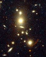
Image credit: Hubble
Many examples are known where a galaxy acts as a gravitational lens, producing multiple images on the sky of a more distant object like a bright quasar hidden behind it. But there has been a persistent mystery for over 20 years: Einstein’s general theory of relativity predicts there should be an odd number of images, yet almost all observed lenses have only 2 or 4 known images. Now, astronomer Joshua Winn of the Harvard-Smithsonian Center for Astrophysics (CfA) and two former CfA colleagues, David Rusin (now at the University of Pennsylvania) and Christopher Kochanek (The Ohio State University), have identified a third, central image of a lensed quasar. Radio observations of the system known as PMN J1632-0033 in the constellation Ophiuchus uncovered a faint central image, which can be used to investigate the properties of the lensing galaxy and the supermassive black hole expected to lie at its center.

“Finding this central image is interesting in its own right, but is even more important for what it can tell us about the lensing galaxy. This offers us a new tool for studying galaxies so far away that, even to the Hubble Space Telescope, they’re just faint smudges,” said Winn.

Quasars are extremely distant and bright objects believed to be powered by supermassive black holes. They shine brightly by converting the gravitational energy of matter falling into the black hole into light and other types of radiation, such as radio waves.

In gravitational lensing, light rays from a quasar which pass close to a galaxy are bent by the galaxy’s gravitational field, much as they would be bent when passing through a glass lens. The denser the center of a galaxy, and the stronger its gravity, the fainter the central image will be. Yet this central image, whose light has passed closest to the middle of the lensing galaxy, can tell us much about that galaxy’s core. That opportunity makes finding such central images particularly desirable.

In the system PMN J1632-0033, a radio-loud quasar at redshift z=3.42 (a distance of about 11.5 billion light-years) is being lensed by an elliptical galaxy at redshift z~1 (about 8 billion light-years away). Two images of the quasar were known to exist, and a third, very faint radio source was suspected to be the central image. However, that third source was right on top of the lensing galaxy, and so might have been intrinsic to the lensing galaxy itself.

By observing the radio “color,” or spectrum, of all three images using the National Science Foundation’s Very Large Array and Very Long Baseline Array, Winn and his colleagues provided compelling evidence that the third source is indeed the quasar’s central image. Its spectrum is essentially identical to the other two images, except at low frequencies where some of the radio energy was absorbed by the lensing galaxy.

The geometry and properties of the quasar’s three images already are telling us about the core of the lensing galaxy. For example, its central black hole weighs less than 200 million solar masses. Also, its surface density (amount of matter as projected against the plane of the sky) at the location of the central image is more than 20,000 solar masses per square parsec. (For comparison, the surface density of the Milky Way near our sun is about 50 solar masses per square parsec.) Both figures for the lensing galaxy agree with expectations based on detailed observations of galaxies hundreds of times closer to the Earth.

“Almost all of our knowledge about galaxy centers comes from studying very nearby galaxies. The remarkable thing about central images is that you can get similar information about the cores of galaxies hundreds of times farther away, and billions of years younger than our neighboring galaxies,” said Winn.

This research is available online at http://arxiv.org/abs/astro-ph/0312136 and will be published in the February 12, 2004 issue of the journal Nature.

Headquartered in Cambridge, Mass., the Harvard-Smithsonian Center for Astrophysics is a joint collaboration between the Smithsonian Astrophysical Observatory and the Harvard College Observatory. CfA scientists, organized into six research divisions, study the origin, evolution and ultimate fate of the universe.

Original Source: Harvard CfA News Release

Rosetta Attached to Its Launch Hardware

Image credit: Arianespace
Preparations for Flight 158 entered a new phase this week as the mission’s Rosetta payload made its initial contact with hardware from the Ariane 5 launcher.

This activity occurred in the Spaceport’s S3B clean room, where Rosetta was positioned on a cone-shaped adapter that serves as the interface structure between the deep-space probe and Ariane 5.

Rosetta is now ready for its transfer to the Ariane 5 Final Assembly building, where the probe will be encapsulated in its protective payload fairing and then installed atop the launch vehicle.

Liftoff of Flight 158 is set for the early morning hours of February 26 from the Spaceport’s ELA-3 launch complex. Instead of a typical launch window used for missions geostationary satellite payloads, Flight 158 has two specific launch slots: one at 49 seconds past 4:16 a.m., and the other at 49 seconds past 4:36 a.m.

Duration of Flight 158 also is unusual for an Ariane 5 mission. After a standard separation of the two solid booster stages and burnout of the central core stage, the Ariane 5’s EPS upper stage will enter a prolonged ballistic phase, followed by its ignition at almost 2 hours after liftoff. Rosetta will be separated from the stage approximately 14 minutes later, embarking on an Earth escape trajectory that will lead to its encounter with comet Churyumov-Gerasimenko in 2014.

Rosetta uses a cubic-shaped spacecraft bus built by Astrium in Germany, and has a liftoff mass of about 3,000 kg. The comet-intercept was under responsibility of the European Space Agency and will include the deployment of a small lander to the surface of Churyumov-Gerasimenko.

Original Source: Arianespace News Release

Close Examination of Bedrock Reveals More Clues

Image credit: NASA/JPL
Scientists are excited to see new details of layered rocks in Opportunity Ledge. In previous panoramic camera images, geologists saw that some rocks in the outcrop had thin layers, and images sent to Earth on sol 17 (Feb. 10, 2004) now show that the thin layers are not always parallel to each other like lines on notebook paper. Instead, if you look closely at this image from an angle, you will notice that the lines converge and diverge at low angles. These unparallel lines give unparalleled clues that some “moving current” such as volcanic flow, wind, or water formed these rocks. These layers with converging and diverging lines are a significant discovery for scientists who are on route to rigorously test the water hypothesis. The main task for both rovers in coming weeks and months is to explore the areas around their landing sites for evidence in rocks and soils about whether those areas ever had environments that were watery and possibly suitable for sustaining life. This is a cropped image taken by Opportunity’s panoramic camera on sol 16 (Feb. 9, 2004).

JPL, a division of the California Institute of Technology in Pasadena, manages the Mars Exploration Rover project for NASA’s Office of Space Science, Washington, D.C.

Original Source: NASA/JPL

Cities on Fertile Land Affect Climate

Image credit: NASA
While cities provide vital habitat for human beings to thrive, it appears U.S. cities have been built on the most fertile soils, lessening contributions of these lands to Earth’s food web and human agriculture, according to a study by NASA researchers and others.

Though cities account for just 3 percent of continental U.S. land area, the food and fiber that could be grown there rivals current production on all U.S. agricultural lands, which cover 29 percent of the country. Marc Imhoff, NASA researcher and lead author of a current paper, and co-author Lahouari Bounoua, of NASA and University of Maryland, College Park, added that throughout history humans have settled in areas with the best lands for growing food.

“Urbanization follows agriculture — it’s a natural and important human process,” said Imhoff.Throughout history, highly productive agricultural land brought food, wealth and trade to an area, all of which fostered settlements.

“Urbanization is not a bad thing. It’s a very useful way for societies to get together and share resources,” said Bounoua. “But it would be better if it were planned in conjunction with other environmental factors.” Studies like this one, which appears in the current issue of Remote Sensing of Environment, may lead to smarter urban-growth strategies in the future.

The researchers used two satellites offering a combination of daytime and nighttime Earth observation data and a biophysical computer model to derive estimates of annual Net Primary Productivity (NPP). NPP measures plant growth by describing the rate at which plants use carbon from the atmosphere to build new organic matter through photosynthesis. NPP fuels Earth’s complex food web and quantifies amounts of carbon dioxide, a greenhouse gas, which plants remove from the atmosphere.

Nighttime-lights data from the Defense Meteorological Satellite Program and a vegetation-classification map created at NASA’s Goddard Institute of Space Studies, New York, were used to portray urban, peripheral and non-urban areas across the United States. In this way, the researchers calculated the extent and locations of U.S. urban and agricultural land.

In addition, observations from the Advanced Very High Resolution Radiometer instrument, aboard the National Oceanic and Atmospheric Administration’s polar orbiting satellites, were used to calculate the Normalized Difference Vegetation Index. This index is a measure of plant health, based on the principle that plants absorb solar radiation in the red part of the spectrum of sunlight used for photosynthesis during plant growth. These data were then entered into a Stanford University computer model to derive NPP.

The computer model created a potential pre-urban American landscape, which was used to compare and estimate the reduction of NPP due to current urban-land transformation.

For the continental United States, when compared to the pre- urban landscape, modern cities account for a 1.6 percent annual decline in NPP. This loss offsets the gain in NPP of 1.8 percent annually from increased farmlands. The result is striking, given the small area that cities cover, relative to agricultural areas.

A reduction of this magnitude has vastly unknown consequences for biological diversity, but it translates to less available energy for the species that make up Earth’s complex food web. The loss of highly fertile lands for farming also puts pressure on other means to meet the food and fiber needs of an increasing population. On the local scale, urbanization can increase NPP, but only where natural resources are limited. It brings water to arid areas, and “urban heat islands” extend the growing season around the urban fringe in cold regions. These benefits, however, do not offset the overall negative impact of urbanization on NPP.

NASA scientists developed the city lights map, and the U.S. Geological Survey used a technique to create the Normalized Difference Vegetation Index data. Research partners include the University of Maryland’s Earth System Science Interdisciplinary Center, the World Wildlife Fund, and the Center for Conservation Biology at Stanford University.

Original Source: NASA News Release

Wallpaper: Olympus Mons

Image credit: ESA
View from overhead of the complex caldera (summit crater) at the summit of Olympus Mons on Mars, the highest volcano in our Solar System.

Olympus Mons has an average elevation of 22 km and the caldera has a depth of about 3 km. This is the first high-resolution colour image of the complete caldera of Olympus Mons.

The image was taken from a height of 273 km during orbit 37 by the High Resolution Stereo Camera (HRSC) on ESA?s Mars Express on 21 January 2004. The view is centred at 18.3?N and 227?E. The image is about 102 km across with a resolution of 12 m per pixel. South is at the top.

This complementary 3D view shows the Olympus Mons volcano in its entirety, to put the caldera images in context. It has been derived from the Mars Orbiter Laser Altimeter (MOLA) topographic data superimposed with the Mars Orbiter Camera (MOC) wide-angle image

Original Source: ESA News Release

New Instruments for Fast Changing Objects

Image credit: ULTRACAM
Although there are numerous telescopes – both large and small – examining the night sky at any one time, the heavens are so vast and so densely populated with all manner of exotic objects that it is extremely easy to overlook a significant random event. Fortunately, a new generation of scientific instruments is now enabling UK astronomers to prepare for the unexpected and become leaders in so-called “Time Domain Astrophysics”.

Exciting new observations of many different, time-variable celestial objects, ranging from black hole X-ray binaries to flare stars and Saturn’s moon Titan will be presented at a Royal Astronomical Society Specialist Discussion Meeting on Friday, 13 February (details below). The meeting will also feature presentations on several ground-breaking UK instruments which make these observations possible.

The Universe around us is constantly changing. Sometimes, the map of the heavens is rewritten by sudden, violent events such as gamma ray bursts (GRBs) and supernovae. Sometimes, a wandering near-Earth asteroid or a gravitational lensing event makes its unpredictable appearance. Most frequently, a star will undergo a modest fluctuation in optical brightness or energy output.

Observing such apparitions and variations can unlock the secrets of a wide variety of the most intriguing and important astronomical objects. Unfortunately, it has proved surprisingly difficult to undertake the type of observations that are required using conventional telescopes and their instruments to solve many outstanding puzzles.

In order to understand these types of phenomena, it is necessary to conduct long term monitoring programmes or to be able to react within minutes to chance discoveries made by other observatories or spacecraft.

“A new generation of facilities, designed and built in the UK, is poised to give the nation’s astronomers a world-leading position in what is dubbed the ‘Time Domain’,” said Professor Mike Bode of Liverpool John Moores University, co-organiser with Professor Phil Charles (Southampton University) of the Royal Astronomical Society meeting about the latest technological breakthroughs in observational astronomy.

This new generation includes the “ULTRACAM” high speed camera, which is being used on various front-rank telescopes around the world. A collaboration between Sheffield and Warwick Universities and the Astronomy Technology Centre, Edinburgh, ULTRACAM can observe changes in brightness lasting only a few thousandths of a second. It has been used to explore the environments of objects as diverse as the atmosphere of Saturn’s smog-shrouded moon, Titan, to the last gasps of gas spiralling into black holes.

Another pioneering instrument is “Super WASP”, a novel telescope comprising effectively five wide-angle cameras. Led by astronomers from a consortium of UK universities, including Queens Belfast, Cambridge, Leicester, Open, and St Andrews, as well as the Isaac Newton Group on La Palma in the Canary Islands, the first Super WASP began operations on La Palma in November 2003.

With its very wide field of view, the telescope can image at any one time an area of sky equivalent to around 1,000 times that of the full Moon. In this way, it is able to observe hundreds of thousands of stars per night, looking for changes in brightness, and discovering new objects. In particular, Super WASP will play a key role in the search for planets in other star systems as they cross the face of their parent star and the flashes of light that may accompany the most dramatic, and enigmatic, explosions since the Big Bang – the so-called Gamma Ray Bursters. In the course of its work, Super WASP will also discover countless asteroids in our own Solar System.

The third of the new facilities is the Liverpool Telescope (LT) on La Palma, pioneering the next-generation robotic telescopes that is being built in Birkenhead by Telescope Technologies Ltd. With its 2m (6.6ft) diameter main mirror, which makes it the largest robotic telescope dedicated to research ever built, the LT started science operations in January 2004. It is owned and operated as a “space probe on the ground” by Liverpool John Moores University (JMU), and supported by funding from JMU, the Particle Physics and Astronomy Research Council, the European Union, the Higher Education Funding Council and the generous benefaction of Mr Aldham Robarts.

Although only operational for just under a month, the LT has already observed a wide range of objects from comets and asteroids, through exploding stars (novae and supernovae) to the variations in light of the centres of active galaxies where it is thought that supermassive black holes may be lurking.

The RAS meeting will also be presented with a vision of the future in which a network of giant robotic telescopes like the LT would be sited around the globe. This robotic telescope network (“RoboNet”) would act as a single, fast-reacting telescope, able to observe objects anywhere on the sky at any time and to follow them 24 hours a day if necessary.

Taking advantage of developments in internet technology, the network will be automatically and intelligently controlled by software developed by the e-STAR project (a collaboration between Exeter University and JMU). e-STAR links the telescopes via “intelligent agents” directly to archives and databases, so that follow-up observations of objects that are seen to vary can automatically be undertaken without human intervention.

Plans are already being considered for a prototype RoboNet based around the LT and its (primarily educational) clones, the Faulkes Telescopes, in Hawaii and Australia. This would lead next to the establishment of a dedicated network in the southern hemisphere searching for planets around other stars. The REX (the Robotic Exo-planet discovery network) project, led by the University of St Andrews, holds out the best prospects for the detection of Earth-like planets around other stars prior to the launch of vastly more expensive space-based observatories in the next decade.

Original Source: RAS News Release

Ozone Destroying Molecule Found

Image credit: NASA
Using measurements from a NASA aircraft flying over the Arctic, Harvard University scientists have made the first observations of a molecule that researchers have long theorized plays a key role in destroying stratospheric ozone, chlorine peroxide.

Analysis of these measurements was conducted using a computer simulation of atmospheric chemistry developed by scientists at NASA’s Jet Propulsion Laboratory (JPL), Pasadena, Calif.

The common name atmospheric scientists use for the molecule is “chlorine monoxide dimer” since it is made up of two identical chlorine-based molecules of chlorine monoxide, bonded together. The dimer has been created and detected in the laboratory; in the atmosphere it is thought to exist only in the particularly cold stratosphere over Polar Regions when chlorine monoxide levels are relatively high.

“We knew, from observations dating from 1987, that the high ozone loss was linked with high levels of chlorine monoxide, but we had never actually detected the chlorine peroxide before,” said Harvard scientist and lead author of the paper, Rick Stimpfle.

The atmospheric abundance of chlorine peroxide was quantified using a novel arrangement of an ultraviolet, resonance fluorescence-detection instrument that had previously been used to quantify levels of chlorine monoxide in the Antarctic and Arctic stratosphere.

We’ve observed chlorine monoxide in the Arctic and Antarctic for years and from that inferred that this dimer molecule must exist and it must exist in large quantities, but until now we had never been able to see it,” said Ross Salawitch, a co-author on the paper and a researcher at JPL.

Chlorine monoxide and its dimer originate primarily from halocarbons, molecules created by humans for industrial uses like refrigeration. Use of halocarbons has been banned by the Montreal Protocol, but they persist in the atmosphere for decades. “Most of the chlorine in the stratosphere continues to come from human-induced sources,” Stimpfle added.

Chlorine peroxide triggers ozone destruction when the molecule absorbs sunlight and breaks into two chlorine atoms and an oxygen molecule. Free chlorine atoms are highly reactive with ozone molecules, thereby breaking them up, and reducing ozone. Within the process of breaking down ozone, chlorine peroxide forms again, restarting the process of ozone destruction.

“You are now back to where you started with respect to the chlorine peroxide molecule. But in the process you have converted two ozone molecules into three oxygen molecules. This is the definition of ozone loss,” Stimpfle concluded.

“Direct measurements of chlorine peroxide enable us to better quantify ozone loss processes that occur in the polar winter stratosphere,” said Mike Kurylo, NASA Upper Atmosphere Research Program manager, NASA Headquarters, Washington.

“By integrating our knowledge about chemistry over the polar regions, which we get from aircraft-based in situ measurements, with the global pictures of ozone and other atmospheric molecules, which we get from research satellites, NASA can improve the models that scientists use to forecast the future evolution of ozone amounts and how they will respond to the decreasing atmospheric levels of halocarbons, resulting from the implementation of the Montreal Protocol,” Kurylo added.

These results were acquired during a joint U.S.-European science mission, the Stratospheric Aerosol and Gas Experiment III Ozone Loss and Validation Experiment/Third European Stratospheric Experiment on Ozone 2000. The mission was conducted in Kiruna, Sweden, from November 1999 to March 2000.

During the campaign, scientists used computer models for stratospheric meteorology and chemistry to direct the ER-2 aircraft to the regions of the atmosphere where chlorine peroxide was expected to be present. The flexibility of the ER-2 enabled these interesting regions of the atmosphere to be sampled.

Original Source: NASA News Release

Both Rovers on the Move

Image credit: NASA/JPL
NASA’s Spirit rover has begun making some of its own driving decisions while its twin, Opportunity, is presenting scientists with decisions to make about studying small spheres embedded in bedrock, like berries in a muffin.

Both rovers are on the move. Late Sunday, Spirit drove about 6.4 meters (21 feet), passing right over the rock called “Adirondack,” where it had finished examining the rock’s interior revealed by successfully grinding away the surface. The drive tested the rover’s autonomous navigation ability for the first time on Mars.

“We’ve entered a new phase of the mission,” said Dr. Mark Maimone, rover mobility software engineer at NASA’s Jet Propulsion Laboratory, Pasadena, Calif. When the rover is navigating itself, it gets a command telling it where to end up, and it evaluates the terrain with stereo imaging to choose the best way to get there. It must avoid any obstacles it identifies. This capability is expected to enable longer daily drives than depending on step-by-step navigation commands from Earth. Tonight, Spirit will be commanded to drive farther on a northeastward course toward a crater nicknamed “Bonneville.”

Over the weekend, Spirit drilled the first artificial hole in a rock on Mars. Its rock abrasion tool ground the surface off Adirondack in a patch 45.5 millimeters (1.8 inches) in diameter and 2.65 millimeters (0.1 inch) deep. Examination of the freshly exposed interior with the rover?s microscopic imager and other instruments confirmed that the rock is volcanic basalt.

Opportunity drove about 4 meters (13 feet) today. It moved to a second point in a counterclockwise survey of a rock outcrop called “Opportunity Ledge” along the inner wall of the rover’s landing-site crater. Pictures taken at the first point in that survey reveal gray spherules, or small spheres, within the layered rocks and also loose on the ground nearby.

NASA now knows the location of Opportunity’s landing site crater, which is 22 meters (72 feet) in diameter. Radio signals gave a preliminary location less than an hour after landing, and additional information from communications with NASA’s Mars Odyssey orbiter soon narrowed the estimate, said JPL’s Tim McElrath, deputy chief of the navigation team.

As Opportunity neared the ground, winds changed its course from eastbound to northbound, according to analysis of data recorded during the landing. “It’s as if the crater were attracting us somehow,” said JPL’s Dr. Andrew Johnson, engineer for a system that estimated the spacecraft’s horizontal motion during the landing. The spacecraft bounced 26 times and rolled about 200 meters (about 220 yards) before coming to rest inside the crater, whose outcrop represents a bonanza for geologists on the mission.

JPL geologist Dr. Tim Parker was able to correlate a few features on the horizon above the crater rim with features identified by Mars orbiters, and JPL imaging scientist Dr. Justin Maki identified the spacecraft’s jettisoned backshell and parachute in another Opportunity image showing the outlying plains.

As a clincher, a new image from Mars Global Surveyor’s camera shows the Opportunity lander as a bright feature in the crater. A dark feature near the lander may be the rover. “I won’t know if it’s really the rover until I take another picture after the rover moves,” said Dr. Michael Malin of Malin Space Science Systems, San Diego. He is a member of the rovers’ science team and principal investigator for the camera on Mars Global Surveyor.

Opportunity’s crater is at 1.95 degrees south latitude and 354.47 degrees east longitude, the opposite side of the planet from Spirit’s landing site at 14.57 degrees south latitude and 175.47 degrees east longitude.

The first outcrop rock Opportunity examined up close is finely-layered, buff-colored and in the process of being eroded by windblown sand. “Embedded in it like blueberries in a muffin are these little spherical grains,” said Dr. Steve Squyres of Cornell University, Ithaca, N.Y., principal investigator for the rovers’ scientific instruments. Microscopic images show the gray spheres in various stages of being released from the rock.

“This is wild looking stuff,” Squyres said. “The rock is being eroded away and these spherical grains are dropping out.” The spheres may have formed when molten rock was sprayed into the air by a volcano or a meteor impact. Or, they may be concretions, or accumulated material, formed by minerals coming out of solution as water diffused through rock, he said.

The main task for both rovers in coming weeks and months is to explore the areas around their landing sites for evidence in rocks and soils about whether those areas ever had environments that were watery and possibly suitable for sustaining life.

JPL, a division of the California Institute of Technology in Pasadena, manages the Mars Exploration Rover project for NASA’s Office of Space Science, Washington, D.C. Images and additional information about the project are available from JPL at http://marsrovers.jpl.nasa.gov and from Cornell University at http://athena.cornell.edu.

Original Source: NASA/JPL News Release

NASA Switches Around Upcoming Station Crews

Image credit: NASA
NASA and its International Partners have assigned new crews to fly to the International Space Station this year. As Expedition 9, NASA astronaut Edward Michael “Mike” Fincke and Russian cosmonaut Gennady Padalka will be the next crew to live aboard the complex. NASA astronaut Leroy Chiao and Russian cosmonaut Salizhan S. Sharipov will serve as Expedition 10.

Fincke and Padalka are set for launch April 18 on a six-month mission. Padalka will serve as Expedition 9 commander and Soyuz commander, and Fincke will be the NASA Space Station science officer and flight engineer. They have been training together as a Space Station crew since March 2002.

Chiao and Sharipov will serve as backup for Expedition 9 and as the prime crew for Expedition 10. They’re scheduled to launch to the Space Station in October. Chiao will serve as the expedition commander and NASA science officer, and Sharipov will serve as Soyuz commander and flight engineer. Astronaut William S. McArthur Jr. and cosmonaut Valery I. Tokarev will serve as the Expedition 10 backup crew.

Russia proposed the new assignment to International Space Station partners through the Multilateral Crew Operations Panel (MCOP). The MCOP agreed to the exchange this week. The decision is still subject to internal review by each partner agency, and NASA anticipates that process to be completed soon.

In November 2003, McArthur and cosmonaut Tokarev were named as Expedition 9 commander and flight engineer.

In mid-January, astronaut Chiao was named as the Expedition 9 commander due to a temporary medical issue related to McArthur’s qualification for that long-duration flight.

Following Chiao’s assignment to fly with Tokarev, NASA and its partners continued to evaluate available crew resources for upcoming flights and decided it was optimal to keep teams together. Since Fincke and Padalka had trained together for years, as had Chiao and Sharipov, the partners made the decision to modify the crew assignments.

“As we’ve continued to evaluate the best use of crew training and resources, we altered our plans to accommodate a change in the Expedition 9 and 10 crews,” Chief Astronaut Kent Rominger said. “Fortunately, the partnership has a pool of highly qualified crew members available, which gives us the flexibility to deal with unexpected circumstances. After a very thorough evaluation by our partners, I’m confident that these assignments make the very best use of our crew resources and skills and will ensure the flights’ full success.”

European Space Agency Astronaut Andre Kuipers will also launch aboard the Soyuz with Fincke and Padalka in April. Kuipers will spend about a week aboard the Station conducting scientific experiments under a commercial agreement between the European Space Agency and Russia. Kuipers will return to Earth with Expedition 8 crewmembers Mike Foale and Alexander Kaleri.

Fincke, a U.S. Air Force lieutenant colonel, is a native of Emsworth, Pa. He will be making his first space flight. Fincke has trained as a backup Station crewmember for two previous missions, Expeditions 4 and 5.

Padalka also has trained as a backup Station crewmember with Fincke for Expedition 4. Padalka will be making his second space flight, having completed 198 days aboard the Russian Mir Space Station in February 1999.

Biographies of Chiao and Sharipov can be found online at:

http://www.jsc.nasa.gov/Bios/

For more information about NASA on the Internet, visit:

http://www.nasa.gov

Original Source: NASA News Release

Canada Developing New Polar Satellite

Image credit: CSA
Canada will transform the future of space-based data delivery and lead cutting-edge scientific research about space weather with the launch of its first multi-purpose satellite mission, today announced Stephen Owen, Minister of Public Works and Government Services, on behalf of Lucienne Robillard, Industry Minister and Minister responsible for Canada Economic Development for Quebec Regions and the Canadian Space Agency.

Called CASSIOPE, this mission will require the building of an innovative satellite platform adaptable for a wide range of assignments, including science, technology, Earth observation, geological exploration and high capacity information delivery. MacDonald, Dettwiler and Associates (MDA) of Richmond, B.C., the prime contractor for CASSIOPE, will lead a Canadian industrial team to develop both the space and ground infrastructure and will operate the spacecraft.

“This mission is a vivid example of the strong economy the Government of Canada is striving to achieve for the 21st century, an economy with exciting applications on Earth and in space. This economy will provide well-paying and meaningful work for Canadians,” said Minister Robillard.

“The CASSIOPE mission demonstrates the compounding value of public-private sector partnership in driving leading-edge technologies and science in support of Canadian priorities,” said Minister Owen. “CASSIOPE will enhance the Canadian space industry’s leadership in information delivery from space and showcase our capacity to design innovative small and micro-satellites. It will also contribute to Canada’s longstanding expertise in atmospheric science.”

The Government of Canada is investing more than $140 million in the development of key technologies and stands to derive a substantial return on its investment if these technologies result in commercial success. The Canadian Space Agency (CSA) is providing $63 million and Technology Partnerships Canada (TPC) $77.2 million.

“Our investment in the design of these new space satellites will increase Canadian knowledge and expertise, diversify our space industry and enhance the timely delivery of Canadian payloads on a more frequent basis,” said CSA President Marc Garneau.

Scheduled for launch in 2007, CASSIOPE will initiate the pilot-phase of a new information delivery service called Cascade that will allow very large amounts of information to be delivered to decision-makers anywhere in the world. Future missions could provide a groundbreaking commercial digital package delivery service, creating a veritable Courier-in-the-Sky to customers ranging from resource exploration companies to trade markets.

CASSIOPE will also include an innovative scientific probe carrying a suite of eight scientific instruments, called ePOP, developed by a scientific team led by the University of Calgary. This $10.3 million CSA-funded payload will collect new data and details on space storms in the upper atmosphere and their potentially devastating impacts on radio communications, GPS navigation, and other space-based technologies.

Original Source: CSA News Release