Satellite Photo of Hurricane Isabel

Image credit: NASA

NASA’s Aqua satellite took this overhead view of Hurricane Isabel on September 14, 2003 while it was 650 km north of Puerto Rico. The image was acquired using Aqua’s Moderate Resolution Imaging Spectroradiometer (MODIS). Isabel is currently a category 4 hurricane, with winds as high as 220 km/h – this is about 15 km/h slower than they were on the weekend. Residents, businesses, and even the military are taking precautions in case Isabel doesn’t lose strength and hits the coast of the North America.

The Moderate Resolution Imaging Spectroradiometer (MODIS) instrument onboard NASA’s Aqua satellite captured this image of Hurricane Isabel September 14, 2003. In this image Hurricane Isabel is approximately 400 mi north of Puerto Rico.

*** Note: We’re tracking more satellite photos of the hurricane in the Universe Today forums. Click here to see the updates each day.

Coldest Temperature Ever Created

Image credit: NASA/JPL

Researchers from NASA and MIT have cooled sodium gas to the lowest temperature ever recorded – one-half billionth degree above absolute zero. At absolute zero temperature (-273 degrees Celsius), all molecular motion would stop completely since the cooling process has extracted all energy from the material. The gas needed to be confined in a magnetic field; otherwise it would stick to the walls of the container and be impossible to cool down. The researchers used a similar methodology that led to the Nobel Prize for Physics in 2001with the discovery of Bose-Einstein condesates (where the molecules move together in an orderly way at low temperatures).

NASA-funded researchers at the Massachusetts Institute of Technology (MIT), Cambridge, Mass., have cooled sodium gas to the lowest temperature ever recorded, one-half-billionth degree above absolute zero. This absolute temperature is the point, where no further cooling is possible.

This new temperature is six times lower than the previous record and marks the first time a gas was cooled below one nanokelvin (one billionth of a degree). At absolute zero (-273? Celsius or -460? Fahrenheit), all motion stops, except for tiny atomic vibrations, since the cooling process has extracted all energy from the particles.

By improving cooling methods, scientists have succeeded in getting closer to absolute zero. “To go below one nanokelvin is like running a mile below four minutes for the first time,” said Dr. Wolfgang Ketterle, a physics professor at MIT and co-leader of the research team.

“Ultra-low temperature gases could lead to vast improvements in precision measurements by allowing better atomic clocks and sensors for gravity and rotation,” said Dr. David E. Pritchard, MIT physics professor, pioneer in atom optics, atom interferometry, and co-leader of the team.

In 1995, a group at the University of Colorado, Boulder, Colo., and a MIT group led by Ketterle, cooled atomic gases to below one microkelvin (one millionth degree above absolute zero). In doing so, they discovered a new form of matter, the Bose-Einstein condensate, where the particles march in lockstep instead of flitting around independently. The discovery was recognized with the 2001 Nobel Prize in Physics, which Ketterle shared with his Boulder colleagues Drs. Eric Cornell and Carl Wieman.

Since the 1995 breakthrough, many groups have routinely reached nanokelvin temperatures; with three nanokelvin as the lowest temperature recorded. The new record set by the MIT group is 500 picokelvin or six times lower.

At such low temperatures, atoms cannot be kept in physical containers, because they would stick to the walls. Also, no known container can be cooled to such temperatures. To circumvent this problem, magnets surround the atoms, which keeps the gaseous cloud confined without touching it. To reach the record-low temperatures, the researchers invented a novel way of confining atoms, which they call a “gravito-magnetic trap.” The magnetic fields acted together with gravitational forces to keep the atoms trapped.

All the researchers are affiliated with the MIT physics department, the Research Laboratory of Electronics and the MIT-Harvard Center for Ultracold Atoms, funded by the National Science Foundation. Ketterle, Leanhardt and Pritchard co-authored the low-temperature paper, scheduled to appear in the September 12 issue of Science. NASA, National Science Foundation, the Office of Naval Research and the Army Research Office funded the research.

Ketterle conducts research under NASA’s Fundamental Physics in Physical Sciences Research Program, part of the agency’s Office of Biological and Physical Research, Washington. NASA’s Jet Propulsion Laboratory, Pasadena, Calif., a division of the California Institute of Technology, Pasadena, manages the Fundamental Physics program.

Original Source: NASA News Release

First Public Mars Images Released

Image credit: NASA/JPL

For the past few weeks, NASA has been letting the public select targets for the Mars Global Surveyor spacecraft, and the first image was released today. The location was the summit crater of a giant volcano called Pavonis Mons – the walls and floor of the crater are covered with thick dust. It was suggested by U.S. Marine Lance Corporal Robert F. Sanders, of Jacksonville, N.C. from the hundreds of selections submitted so far. Mars Global Surveyor has taken 120,000 images of the planet’s surface in high detail, but this is only 3% of the entire planet.

If you were given a chance to aim the camera on NASA’s Mars Global Surveyor Mars Orbiter and take a picture of something on the red planet, what would you shoot?

Now we know, after NASA released today the first picture selected from hundreds of public suggestions. The photo reveals a thick layer of dust blanketing the floor and wall of the summit crater atop a tall volcano called Pavonis Mons.

“It’s such a thrill to see it,” said U.S. Marine Lance Corporal Robert F. Sanders, of Jacksonville, N.C., who suggested the crater close up as a photo target for the Mars Global Surveyor camera. “I spent hours coming up with suggestions, but I didn’t know whether any of them would be accepted.”

The resulting picture shows details as small as a large SUV in a strip of ground about 9 kilometers (5.6 miles) long within the summit crater of Pavonis Mons.

“We’ve received hundreds of really good ideas since we began accepting public suggestions last month,” said Dr. Ken Edgett, staff scientist for Malin Space Science Systems, which operates the Mars Orbital Camera. “We were excited last week, when the predicted ground track intersected a publicly suggested location for the first time.” Accepted targets are not imaged until the spacecraft’s regular orbiting pattern goes directly over them.

The captioned image and an accompanying wide-angle view for context are available on the Internet from NASA’s Jet Propulsion Laboratory, Pasadena, Calif., at http://photojournal.jpl.nasa.gov/catalog/PIA04735. They are also available from Malin Space Science Systems, San Diego, at http://www.msss.com/mars_images/moc/2003/09/12/.

The camera on Mars Global Surveyor has returned more than 120,000 pictures since the spacecraft began orbiting Mars on Sept. 12, 1997. Still, its high-resolution images have covered only about three percent of the planet’s surface. Three percent of Mars, while seemingly small, represents a huge amount of “real estate,” or nearly 5 million square kilometers (about 3 million square miles), that has been observed at spectacular resolution.

Information about how to submit suggestions is available on the Internet at the Mars Orbiter Camera Target Request Site, at http://www.msss.com/plan/intro.

“Taking public suggestions enhances the science return,” Edgett said. “Every suggestion we get has the potential for discovery.”

“As Mars Global Surveyor continues its legacy of SUV-scale exploration, we’re excited to offer for the first time an innovative approach for direct public participation in Mars exploration,” said Dr. Jim Garvin, NASA’s lead scientist for Mars. “Increasing the breadth of science activities, by working together with the public to uncover the mysteries of Mars, is an important part of NASA’s mission to inspire the next generation of explorers.”

Information about Mars Global Surveyor is available on the Internet at http://mars.jpl.nasa.gov/mgs.

JPL, a division of the California Institute of Technology, Pasadena, manages Mars Global Surveyor for NASA’s Office of Space Science in Washington. JPL’s industrial partner is Lockheed Martin Space Systems, Denver, which developed and operates the spacecraft. Malin Space Science Systems and the California Institute of Technology built the Mars Orbiter Camera. Malin Space Science Systems operates the camera from facilities in San Diego.

Original Source: NASA/JPL News Release

Galileo Will Plunge Into Jupiter on September 21

Image credit: NASA/JPL

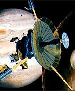
Time is running out for NASA’s Galileo spacecraft. After eight years of loyal service imaging Jupiter and its moons, NASA controllers have aimed it at the gas giant. On September 21, 2003, Galileo will crash into Jupiter and be destroyed; this will prevent any chance the spacecraft will unintentionally crash into Europa and contaminate the liquid ocean. NASA is planning a series of live press conferences to explain the end of the mission and discuss Galileo’s discoveries.

Following eight years of capturing dramatic images and surprising science from Jupiter and its moons, NASA’s Galileo mission draws to a close September 21 with a plunge into Jupiter’s atmosphere. Following eight years of capturing dramatic images and surprising science from Jupiter and its moons, NASA’s Galileo mission draws to a close September 21 with a plunge into Jupiter’s atmosphere.

NASA has scheduled a Space Science Update (SSU) at 2 p.m. EDT, Wednesday., September 17, in the James E. Webb Auditorium at NASA headquarters, 300 E St. S.W., Washington. Panelists will discuss the historic mission, engineering challenges, science highlights and plans for Galileo’s impact with Jupiter’s atmosphere.

The SSU will be carried live on NASA Television with two-way question-and-answer capability from participating agency centers. NASA TV is broadcast on AMC-9, transponder 9C, C-Band, located at 85 degrees west longitude. The frequency is 3880 MHz. Polarization is vertical, and audio is monaural at 6.80 MHz. Audio of the SSU is available on voice circuit from the Kennedy Space Center at: 321/867-1220.

SSU participants:

# Dr. Colleen Hartman, director, Solar System Exploration Division, NASA Headquarters.
# Dr. Claudia Alexander, Galileo project manager, NASA Jet Propulsion Laboratory (JPL), Pasadena, Calif.
# Dr. Michael J.S. Belton, Team Leader, Galileo Solid State Imaging Team, Emeritus Astronomer, National Optical Astronomy Observatories, Tucson, Ariz.
# Dr. Don Williams, principal investigator, Galileo heavy ion counter, The Johns Hopkins University, Applied Physics Laboratory, Laurel, Md.
# Jim Erickson, Mars Exploration Rover Mission Manager and former Galileo project manager, JPL.

The spacecraft was put on a collision course with Jupiter’s atmosphere to eliminate any chance of impact of the moon Europa, which Galileo discovered is likely to have a subsurface ocean. The team expects the spacecraft to transmit a few hours of science measurements in real time, leading up to impact on Sunday, September 21. The maneuver is necessary, since onboard propellant is nearly depleted. Without propellant, the spacecraft would not be able to point its antenna toward Earth nor adjust its flight path, so controlling the spacecraft would no longer be possible.

From 4:00 to 5:00 p.m. EDT, September 21, JPL will provide live commentary from the mission control room and footage of the countdown clock as Galileo nears its final moments. The televised special will feature two panels. One will include former project managers, and the other former project scientists.

Live satellite interview opportunities with project personnel are available Friday, September 19. To book a time, please contact Jack Dawson at: 818/354-0040.

Launched by the Space Shuttle Atlantis in 1989, the mission produced a string of discoveries while circling Jupiter, the solar system’s largest planet, 34 times. Galileo was the first spacecraft to directly measure Jupiter’s atmosphere with a probe and the first to conduct long-term observations of the Jovian system from orbit.

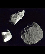
Galileo found evidence of subsurface liquid layers of salt water on Jupiter’s moons Europa, Ganymede and Callisto, and it detected extraordinary levels of volcanic activity on Io. Galileo was the first spacecraft to fly by an asteroid and the first to discover the moon of an asteroid. Galileo’s prime mission ended six years ago after two years orbiting Jupiter. NASA extended the mission three times to take advantage of Galileo’s unique science capabilities.

The September 17 SSU and September 21 end of mission event will be Web cast live at:

http://www.jpl.nasa.gov/webcast/galileo/
Additional information about the mission and Galileo’s discoveries is available at:

http://galileo.jpl.nasa.gov
For information about NASA on the Internet, visit:

http://www.nasa.gov

Original Source: NASA News Release

Iraq Oil Fire Seen From Space

Image credit: ESA

The European Space Agency’s Envisat environmental satellite captured this image of a burning oil pipeline in northern Iraq. The immense black cloud stretched over thousands of square kilometres in the valley between the Tigris and Euphrates rivers. The pipeline transfers oil from Kirkuk to Baija, and another photo from Envisat shows how the area looked before the fire.

A burning oil pipeline in northern Iraq produced an immense cloud of black smoke that stretched across thousands of square kilometres, in this image acquired by Envisat?s Medium Resolution Imaging Spectrometer.

The smoke cloud is visible in the centre of this image of the alluvial plain occupied by the valley of the river Tigris (flowing from the top centre of the image) and the Euphrates (flowing from the top left corner).

The Medium Resolution Imaging Spectrometer (MERIS) on ESA?s Envisat environmental satellite acquired the image on 30 August, the same day as the media reported a fire affecting a segment of oil pipeline near the town of Hawija.

The pipeline transports crude oil from the oil-rich city of Kirkuk ? seen here in grey, on the Tigris River – to Baija, where the country?s largest oil refinery is located. For comparison the second MERIS image shows the same area three days earlier, before the pipeline had been damaged.

The dense cloud of smoke has an extent comparable to the Iranian lake Urmia (which has an area of 4700 square kilometres), seen in turquoise colour towards the top right of the image. Authorities stated it took two days to bring the fire under control.

These three-band MERIS images have a resolution of 1200 metres and were processed by Hamburg-based Brockmann Consult.

Original Source: ESA News Release

NASA Starts Packing up Columbia Debris

With the Columbia accident investigation largely complete, workers at the Kennedy Space Center have begun packing up the 84,000 pieces of debris from the disaster. Unlike the debris from Challenger, which was packed away into two abandoned missile silos after the 1986 disaster, the material from Columbia will probably be made available for research. It may also show up in the Smithsonian Air and Space Museum in Washington, but NASA hasn’t decided if it’s appropriate or not. Officials expect to have the hanger clear of debris by the end of September.

NASA Proposes to Search for Smaller Asteroids

Image credit: NASA/JPL

Five years ago NASA began a program to discover 90% of potential Earth-crossing asteroids larger than 1 km. 60% of the 1,000 to 1,200 large Near Earth Asteroids have already been found, and the search should be complete by 2008. But objects below 1 km can still be devastating, so NASA is proposing a new survey to track hundreds of thousands of these smaller objects. The new report proposes that NASA spend $236 million over the course of 20 years to find 90% of these smaller, but still devastating, objects. Another option would be to build a space-based tracking system which would increase the cost to $397 million but cut the search time down to just seven years.

NASA has released a technical report on potential future search efforts for near-Earth objects after a year of analysis by scientists working on this issue. This Science Definition Team was chartered to study what should be done to find near-Earth objects less than 1 kilometer in size. While impacts by these smaller objects would not be expected to cause global devastation, impacts on land and the tsunamis resulting from ocean impacts could still cause massive regional damage and still pose a significant long-term hazard.

In 1998 NASA commenced its part of the “Spaceguard” effort, with the goal of discovering and tracking over 90% of the near-Earth objects larger than one kilometer by the end of 2008. An Earth impact by one of these relatively large objects would be expected to have global consequences and, over time scales of a few million years, they present the greatest impact hazard to Earth. Approximately 60% of the estimated 1,000 to 1,200 large near-Earth objects have already been discovered, about 45% since NASA efforts started, and each of the five NASA-supported search facilities continue to improve their performance, so there has been good progress toward eliminating the risk of any large, undetected impactor.

To understand the next steps to discovering the population of potentially hazardous asteroids and comets whose orbits can bring them into the Earth’s neighborhood, NASA turned to this Science Definition Team of 12 scientists. The Team, chaired by Dr. Grant Stokes of the MIT Lincoln Laboratory, was asked to study the feasibility of extending the search effort to the far more numerous, perhaps hundreds of thousands, of near-Earth objects whose diameters are less than one kilometer.

NASA considers the Science Definition Team’s findings to be preliminary, and a much more in-depth program definition, refining objectives and estimating costs, would need to be conducted prior to any decision to continue Spaceguard projects beyond the current effort to 2008.

Original Source: NASA News Release

Satellites Help Forecasters Predict Hurricanes

Image credit: NASA

Weather forecasters are turning to data from a fleet of satellites to help predict how conditions might turn into hurricanes that could ravage the coastal areas of Eastern North America. Tropical storms typically appear off the coast of Africa from June to November; some of these will turn into hurricanes depending on many factors. Satellites can now spot many of the warning signs, including a sea surface temperature of at least 27.8 degrees Celsius, rotating winds above the ocean, air temperature, humidity, and finally rainfall intensity.

Every year, from June 1 to November 30, the Atlantic Ocean becomes a meteorological mixing bowl, replete with all the needed ingredients for a hurricane recipe. Forecasters who seek to monitor and understand hurricanes are increasingly turning to a cadre of NASA satellites and instruments, including several from NASA’s Jet Propulsion Laboratory, Pasadena, Calif., that serve up a feast of information on these awesome storms.

Typically, during the peak of hurricane season, from late August to mid-September, tropical cyclones of interest to U.S. coastal regions form around the Cape Verde Islands off Africa. NASA satellites are critical for helping forecasters determine if all of the ingredients are coming together to create a hurricane. If a hurricane forms, it is critical to know how strong it may be, and which coastal communities or sea lanes will be at risk.

NASA provides researchers and forecasters with space-based observations, data assimilation and computer climate modeling. NASA-sponsored measurements and modeling of global sea surface temperature, precipitation, winds and sea surface height have also improved understanding of El Ni?o and La Ni?a events, which respectively tend to suppress and enhance Atlantic and Gulf hurricane development.

Thirty years ago, meteorologists were unable to see the factors in hurricane formation and could only spot a hurricane with still pictures from the Television Infrared Operational Satellite – Next-generation (Tiros-N) spacecraft. Over the past 10 years, visible and infrared satellite sensors were the workhorses for monitoring hurricanes. Today, multiple NASA satellites exploit everything from radar pulses to microwaves for the purpose of enhancing forecasts, providing data to researchers several times a day.

The first ingredient in the hurricane recipe is a sea surface temperature of at least 27.8 degrees Celsius (82 degrees Fahrenheit). Unlike traditional infrared satellite instruments, the Aqua satellite’s Advanced Microwave Scanning Radiometer E and the Tropical Rainfall Measuring Mission’s microwave imager can detect sea surface temperatures through clouds. This valuable information can help determine if a tropical cyclone is likely to strengthen or weaken. The joint U.S.-French Jason-1 satellite altimeter, managed by JPL, provides data on sea surface height, a key measurement of ocean energy available to encourage and sustain hurricanes.

Another necessary ingredient is rotating winds over the ocean’s surface, precursors to tropical cyclone development. The NASA-provided and JPL-built and managed SeaWinds instruments aboard Japan’s Midori 2, and NASA’s Quick Scatterometer (QuikScat) satellites can detect these winds before other instruments, providing even earlier notice of developing storms to forecasters and scientists.

Air temperature and humidity are also important factors. The JPL-managed Atmospheric Infrared Sounder experiment suite aboard the Aqua satellite obtains measurements of global temperature and humidity throughout the atmosphere. This may lead to improved weather forecasts, improved determination of cyclone intensity, location and tracks, and the severe weather associated with storms, such as damaging winds.

Rainfall intensity is the final ingredient, and the precipitation radar provided by Japan for the Tropical Rainfall Measuring Mission satellite provides computed tomography (CAT) scan-like views of rainfall in the massive thunderstorms of hurricanes. The mission’s instruments probe young tropical systems for rainfall intensity and the likelihood of storm development. The mission also sees “hot towers” or vertical columns of rapidly rising air that indicate very strong thunderstorms. These towers are like powerful pistons that convert energy from water vapor into a powerful wind- and rain-producing engine. Once a storm develops, the mission provides an inside view of how organized and tightly spiraled rain bands are, key indicators of storm intensity.

The Tropical Rainfall Measuring Mission provides tropical cyclone intensity information from the safe distance of space, allowing the National Oceanic and Atmospheric Administration’s National Hurricane Center and the Department of Defense Joint Typhoon Warning Center to turn to it, QuikScat and other NASA satellites for early assessment of storms in the open ocean.

The hurricane monitoring capabilities enabled by these satellites are funded by NASA’s Earth Science Enterprise, which is dedicated to understanding Earth as an integrated system and applying Earth system science to improve prediction of climate, weather and natural hazards using the unique vantage point of space.

Original Source: NASA/JPL News Release. Here are some hurricanes pictures.

NASA Approves Mirror for James Webb Telescope

Image credit: NASA

NASA announced today that it has selected a beryllium-based mirror technology for the 6.5 mirror on the James Webb Space Telescope – the successor to the Hubble Space Telescope. The primary mirror will actually be made up of 18 hexagonal-shaped segments, giving it 2.5 times more surface area than Hubble’s mirror; but it will be one-third the weight. Construction of the mirror will begin next year, and the telescope is expected to launch some time after 2011.

NASA today announced a major milestone in the development of the James Webb Space Telescope (JWST), the selection of a beryllium-based mirror technology for the telescope’s 6.5-meter primary mirror.

The JWST prime contractor, Northrop Grumman, Redondo Beach, Calif., recommended that NASA select the mirror technology, supplied by Ball Aerospace & Technologies Corporation, Boulder, Colo., for the JWST primary mirror.

Northrop Grumman made the recommendation following a detailed process that took advantage of insights from a panel of experts representing the contractor team, NASA and the science community. Two mirror technologies, beryllium and ultra low-expansion glass, were tested, and their implementation plans were thoroughly reviewed during a six-month evaluation. Technical performance, manufacturing schedule, facilities, staffing, and cost were factors taken into consideration.

The production of the beryllium-based mirrors will begin within the next year. The mirrors will be incorporated into optical assemblies, mounted on the telescope structure, and subjected to a series of tests at cryogenic temperatures, individually and as an integrated system.

The Observatory design features a 6.5-meter aperture primary mirror, comprised of 18 hexagonal shaped segments. The telescope will be 2.5 times the diameter, yet weigh only one-third as much, as the mirror on the Hubble Space Telescope. JWST will be orders of magnitude more sensitive than ground-based infrared telescopes.

After launch in 2011, JWST will peer into the infrared at great distances to see the first stars and galaxies formed in the universe billions of years ago. A flagship mission in NASA’s Origins Program, JWST will search for answers to astronomers’ fundamental questions about the birth and evolution of galaxies, the size and shape of the universe, and the mysterious life cycle of matter.

NASA’s Goddard Space Flight Center, Greenbelt, Md., manages the JWST project for NASA Headquarters’ Office of Space Science, Washington. The project consists of an international team involving NASA, the European Space Agency, Canadian Space Agency, industry and academia.

Northrop Grumman is prime contractor leading a team including Ball Aerospace, Eastman Kodak Company, Rochester, N.Y.; and Alliant Techsystems, Magna, Utah. The major beryllium mirror subcontractors to Ball Aerospace are Tinsley Laboratories, Richmond, Calif.; Axsys Technologies, Cullman, Ala.; and Brush Wellman Inc., Elmore, Ohio.

Original Source: NASA News Release

Titan Launches Secret Satellite

The US Air Force launched a secret satellite cargo early Tuesday morning on board a Titan IV-B rocket. The satellite is believed to be an Advanced ORION signals intelligence satellite for the National Reconnaissance Office. The Air Force was so secretive about the launch that they were unwilling to release information about its costs, purpose, or even who built it.