Progress Docks with Station

Image credit: NASA

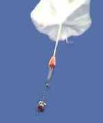
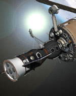
The Russian Progress cargo ship launched last week caught up and docked with the International Space Station on Saturday. It delivered nearly three tons of food, fuel, water, supplies and scientific gear for the next crew to inhabit the station. The Progress 12 automatically linked up with the Zvezda Service Module at 0340 GMT (11:40 pm EDT Friday). Another Progress ship currently docked with the station will undock on Thursday to make room for the Soyuz that will launch with the Expedition 7 astronauts on October 20.

An unpiloted Russian resupply craft successfully docked to the International Space Station tonight, delivering nearly three tons of food, fuel, water, supplies and scientific gear to the Expedition 7 crew aboard the complex and for the next crew to launch in October.

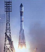
The Progress 12 vehicle automatically linked up to the aft end of the Zvezda Service Module at 10:40 p.m. CDT (0340 GMT), two days after its launch from the Baikonur Cosmodrome in Kazakhstan. As the Progress neared the Space Station for docking, Expedition 7 Commander Yuri Malenchenko and NASA ISS Science Officer Ed Lu were inside Zvezda, monitoring its approach. At the time of contact and capture, the Station was flying over Central Asia at an altitude of 240 statute miles. After conducting leak checks to insure a tight seal between the Progress and the ISS, Malenchenko and Lu will open the hatch to the ship and then begin unloading the supplies.

Stowed in the Progress are replacement parts for Station systems, tools, a satellite telephone and Global Positioning System hardware, next generation laptop computers, educational demonstrations, science experiment gear and office supplies. The Progress also carried to the ISS science equipment for European Space Agency (ESA) Astronaut Pedro Duque of Spain, who is set to launch Oct. 18 from Baikonur on the Soyuz TMA-3 craft with Expedition 8 Commander Mike Foale and Expedition 8 Soyuz Commander and Flight Engineer Alexander Kaleri. Duque will spend eight days aboard the Space Station conducting science experiments under a commercial contract between ESA and the Russian Aviation and Space Agency. Duque will return to Earth on Oct. 28 with Malenchenko and Lu.

The new Progress also carries personal items and hardware for Foale and Kaleri, who are scheduled to spend almost 200 days aboard the ISS.

Another Progress vehicle currently docked to the Pirs Docking Compartment will undock from the ISS on Sept. 4, to clear the way for the arrival of Foale, Kaleri and Duque in the Soyuz TMA-3 on Oct. 20.

Information on the crew’s activities aboard the Space Station, future launch dates, as well as Station sighting opportunities from anywhere on the Earth, is available on the Internet at:

http://spaceflight.nasa.gov/

Details on Station science operations can be found on an Internet site administered by the Payload Operations Center at NASA’s Marshall Space Flight Center in Huntsville, Ala., at:

http://scipoc.msfc.nasa.gov/

The next ISS status report will be issued on Friday, Sept. 5, or earlier, if events warrant

Original Source: NASA Status Report

Farewell Mars

It’s been a couple of days since Mars made its closest approach so it’s time for the news media to completely and utterly forget about it and move onto something new. The reality, though, is that Mars is going to remain bright and close for several months. It’ll still incredible in many small telescopes well into September and even October. Even better than that, it will be visible higher in the sky at earlier times. Instead of waiting for it to rise through the murk at the horizon, you can just wait until it gets dark and then, bang, there it is.

If you tried to attend an event, I know everywhere was busy. I’ve heard stories of two-hour lineups just for a chance to look through a telescope. Yikes. Some astronomy clubs have chosen to organize their events in September, so take another look at my list of Mars 2003 events.

Fraser Cain
Publisher
Universe Today

P.S. I’ve had complaints from AOL subscribers that they aren’t receiving the newsletter – I suspect some aggressive SPAM-filter. If you’re on AOL, can you let me know if you’re receiving this?

How Huygens Will Land on Titan

Image credit: ESA

One significant event in the Cassini mission will be when the Huygens probe is deployed to Saturn’s largest moon Titan in early 2005. A team of scientists from the European Space Agency recently tested how their probe will perform on the long drop through Titan’s atmosphere by dropping a replica here on Earth. The mock-up was dropped from an altitude of 33 km on a balloon and it used a parachute to slow its return to Earth. ESA controllers use the descent time to calibrate the instrumentation that will communicate with the real Huygens probe when it makes its visit to Titan.

You need to have thought of almost every eventuality when landing on a distant moon in a remote corner of the Solar System. You must have tested your spacecraft to its limits to be sure it will withstand the extreme conditions expected on Titan, a moon of Saturn.

Moreover, you have to gather in advance as much information as you can about the way your instruments will work in those conditions. It is only when the scientific instruments work properly that you can say your mission has been successful.

Descending through poisonous gas
In early 2005, ESA’s Huygens probe will descend through the cloak of noxious gases surrounding Titan, Saturn’s largest and most mysterious moon. An Italian-led team of European scientists and engineers have ingeniously tackled the challenges of testing the reliability, behaviour, and response of some of the probe’s instruments in actual operation ? not simulations.

Using a combination of balloon and parachute, the team had a creative way of testing a full-scale replica of the Huygens space probe ? they dropped it from 33 kilometres above the Earth! The air we breathe on Earth is very different from the poisonous smog of Titan, but Jean-Pierre Lebreton, ESA Huygens Project Scientist, says that the way in which the properties of our atmosphere change are similar to the behaviour of Titan?s atmosphere.

On 6 June 2003, the scientists gathered at the Italian Space Agency’s Trapani balloon-launch facility in Sicily. To launch the 500-kilogram gondola carrying the mock-up Huygens space probe, they used a helium balloon that fully inflated to a diameter of 100 metres (corresponding to a total volume of 400 000 cubic metres) at its maximum altitude. When the balloon reached a height of 33 kilometres, a release mechanism opened and dropped the probe.

The on-board parachute deployed to slow the probe’s fall from 40 metres per second to just 4 metres per second. At that speed, the probe floated gently back to Earth, taking about 30 minutes to complete its journey beneath the ten-metre-wide parachute. This parachute was designed to provide a fall speed very close to the one expected at Titan.

“Altimeter 1, are you receiving me?”
The flight allowed scientists to collect data under conditions which are as representative as possible in Europe of the future flight to millions of kilometres away from the Earth. In this way, they can really begin to understand the instrument characteristics very well. Scientists call this process calibration.

Not only are these training exercises important to understand the behaviour of the instruments and the data, they also contribute to building team spirit for when the real thrills start at Titan!

This drop was the fourth test flight of the Huygens instruments on Earth (the first such test took place in Spain during 1995, the following two were done in Sicily). This flight was the first to have a fully equipped Huygens mock-up, including the complete Huygens Atmospheric Structure Instrument (H-ASI) provided by Italy. Once on Titan, the purpose of H-ASI will be to study the temperature, pressure, electrical properties, and the winds in this exotic atmosphere.

A mock-up of one of the two Huygens altimeters, mounted on the replica probe was also tested during this balloon flight. The altimeters measure the probe’s height from the ground. “We have analysed the data. From what we have seen so far, the altimeter worked well,” says Lebreton. “The test makes me very confident that the two altimeters on Huygens will work well at Titan.”

“One of the other exciting and comforting aspects of this test flight was to see how good the probe was at stabilising itself during the descent when atmospheric turbulences disturbed the fall, thanks to its special parachute design. We can then confidently expect we will have a flawless drop through Titan?s atmosphere in early 2005,” says Enrico Flamini, ASI Project Manager for Huygens, responsible for this test campaign.

The scientists are now considering a final drop during 2004 over Antarctica. This location is the one on Earth that best resembles Titan’s atmospheric conditions, in terms of pressure, electrical properties, and temperatures. Titan’s temperatures can drop to about ?180?C!

Original Source: ESA News Release

Progress Supply Ship Launches for the Station

Image credit: RSA

An unmanned Progress 12 supply ship launched from the Baikonur Cosmodrome in Kazakhstan to deliver a new cargo of 2.7 tonnes of food, fuel and water to the International Space Station. The Progress lifted off at 0148 GMT Friday (9:48 pm EDT Thursday) and reached orbit 10 minutes later. The station’s previous Progress, filled with trash, was undocked to make room for the new cargo ship and commanded to re-enter the Earth’s atmosphere and burn up.

An unmanned Russian Progress vehicle successfully blasted off from the Baikonur Cosmodrome in Kazakhstan tonight to deliver almost three tons of food, fuel, water, and supplies to the residents of the International Space Station.

The Progress 12 craft lifted off right on time from its Central Asian launch pad at 8:48 p.m. CDT (148 GMT Aug. 29) as the ISS sailed over the south Atlantic Ocean east of South America at an altitude of 240 statute miles. Less than 10 minutes later, the Progress settled into its preliminary orbit and its solar arrays and navigational antennas were successfully deployed.

Aboard the ISS, Expedition 7 Commander Yuri Malenchenko and NASA ISS Science Officer Ed Lu were already in their sleep period as the Progress climbed to orbit.

The new Progress is scheduled to dock to the aft port of the Zvezda Service Module on Saturday night at 10:45 p.m. CDT (345 GMT Aug. 31). Another Progress ship that arrived at the ISS in February filled with discarded items and trash was undocked yesterday and commanded to deorbit, burning up in the Earth?s atmosphere.

Progress 12 is loaded with supplies for Malenchenko and Lu and science gear for European Space Agency astronaut Pedro Duque of Spain, who is set to launch October 18 from Baikonur on the Soyuz TMA-3 craft with Expedition 8 Commander Mike Foale and Expedition 8 Soyuz Commander and Flight Engineer Alexander Kaleri. Duque will spend eight days aboard the ISS conducting science experiments under a commercial contract between ESA and the Russian Aviation and Space Agency. Duque will return to Earth on Oct. 28 with Malenchenko and Lu.

Among the supplies aboard the Progress is a satellite phone and Global Positioning System locator hardware which Malenchenko, Lu and Duque would use in the unlikely event they land off-course, as did the Expedition Six crew back in May.

The new Progress also carries personal items and hardware for Foale and Kaleri, who are scheduled to spend almost 200 days aboard the ISS.

Another Progress vehicle currently docked to the Pirs Docking Compartment will undock from the ISS on September 4 to clear the way for the arrival of Foale, Kaleri and Duque in the Soyuz TMA-3 on October 20.

Information on the crew’s continuing activities on the Space Station, future launch dates and Station sighting opportunities from anywhere on Earth is available at:

http://spaceflight.nasa.gov/

Details on Station science operations can be found on an Internet site administered by the Payload Operations Center at NASA’s Marshall Space Flight Center in Huntsville, Ala., at:

http://scipoc.msfc.nasa.gov/

The next ISS status report will be issued on Saturday, August 30 following the Progress 12 docking, or sooner if events warrant.

Original Source: NASA Status Report

Earth-Based Telescopes Search for Martian Water

Image credit: UKIRT

Astronomers are searching for evidence of past water on Mars from the comfort of an observatory in Hawaii. They’re using the United Kingdom Infrared Telescope (UKIRT) to map the spectral signature given off of minerals on the Red Planet’s surface. They’re looking for minerals, such as hydrated clay, which would indicate the past presence of liquid water. NASA’s two Mars Exploration Rovers will be searching for similar signs on Mars when they arrive in January 2004.

As Mars makes its closest approach in almost 60,000 years, two Australian astronomers have used the United Kingdom Infrared Telescope (UKIRT) in Hawai`i to look for signs that the planet once had liquid water – and so may have hosted life.

Dr. Jeremy Bailey of the Anglo-Australian Observatory and the Australian Centre for Astrobiology (ACA) at Macquarie University in Sydney, and Sarah Chamberlain, a PhD student at the ACA, have produced what is Bailey says is “perhaps the sharpest image of Mars ever made from the ground.”

But the real gold lies in the spectral data they obtained.

The scientists are applying the same remote-sensing technique that geologists use to map minerals on the Earth’s surface.

Minerals absorb some wavelengths from sunshine and reflect others. Each mineral has its own ‘spectral signature’ – the set of wavelengths it reflects.

“We’re looking particularly for the signatures of minerals, such as hydrated clay minerals, that would indicate the past presence of liquid water,” said Bailey.

Similar prospecting by NASA’s Mars Odyssey spacecraft has shown that there is a vast amount of hydrogen below the surface of Mars. The consensus has been that this is probably water ice.

But did Mars ever have liquid water? And if so, how much? It’s still contentious.

NASA’s Mars Global Surveyor has found sizeable deposits of a mineral called crystalline (grey) hematite, which forms only in the presence of liquid water.

NASA’s two Mars Exploration Rovers, due to land on the Martian surface in January 2004, and the UK lander Beagle 2, due to land in December this year, will also be looking for signs that Mars has had liquid water.

“While spacecraft can get up close, ground-based observations still have a role, as they allow us to use larger and more powerful instruments,” said Bailey.

UKIRT, with a 3.8-m diameter aperture, is the world’s largest telescope devoted specifically to infrared observations.

UKIRT is funded by PPARC, the UK Particle Physics and Astronomy Research Council. The Anglo-Australian Observatory is funded by the UK Government, through PPARC, and the Australian Government.

Observations: Jeremy Bailey (Anglo-Australian Observatory and Australian Centre for Astrobiology, Macquarie University) and Sarah Chamberlain (Australian Centre for Astrobiology, Macquarie University). Data processing: Chris J. Davis, Joint Astronomy Centre, Hawai’i.

Original Source: Joint Astronomy Centre News Release

Infrared Ring Around a Young Star

Image credit: ESO

A new image taken by the European Southern Observatory’s Very Large Telescope (VLT) shows an infrared halo around a nascent star. The image also shows jets of gas emanating from the region and colliding with the surrounding cloud. Although these rings have been theorized before, this is the first time one has actually been seen. The dust in the surrounding cloud is collapsing under its own gravity and will eventually form a true star.

A small and dark interstellar cloud with the rather cryptic name of DC303.8-14.2 is located in the inner part of the Milky Way galaxy. It is seen in the southern constellation Chamaeleon and consists of dust and gas. Astronomers classify it as a typical example of a “globule”.

As many other globules, this cloud is also giving birth to a star. Some years ago, observations in the infrared spectral region with the ESA IRAS satellite observatory detected the signature of a nascent star at its centre. Subsequent observations with the Swedish ESO Submillimetre Telescope (SEST) at La Silla (Chile) were carried out by Finnish astronomer Kimmo Lehtinen. He revealed that DC303.8-14.2 is collapsing under its own gravity, a process which will ultimately result in the birth of a new star from the gas and dust in this cloud.

Additional SEST observations of the millimetre emission of carbon monoxide (CO) molecules demonstrated a strong outflow from the nascent star. A small part of the gas that falls inward onto the central object is re-injected into the surrounding via this outward-bound “bipolar stream”.

The structure of DC303.8-14.2
The left panel in PR Photo 26a/03 shows the DC303.8-14.2 globule as it looks in red light. This image was obtained at wavelength 700 nm and has been reproduced from the Digitized Sky Survey (DSS) [1]. It covers a sky region of 20 x 20 arcmin2, or about 50% of the area of the full moon. The dust particles in the cloud reflect the light from stars, causing the cloud to appear brighter than the adjacent sky.

The brightness distribution over the cloud depends mostly on three factors connected to the dust. The first is the distribution of dust grains in the cloud, the way the dust density changes with the distance from the centre of the cloud. The second is the relative amount of light that is reflected by the dust particles. The third indicates the dominant direction in which the dust particles scatter light; this is dependent on the geometry of the grains and their preferred spatial alignment. Accurate observations of the brightness distribution over the surface of a globule allow an investigation of these properties and thus to learn more about the structure and composition of the cloud.

From the image obtained in red light (left panel in PR Photo 26a/03) it appears, somewhat surprisingly, that the brightest area of DC303.8-14.2 is not where there is most dust. Instead, it takes the form of a bright ring around the centre. This rim corresponds to a region where the intensity of the light from stars behind the cloud is reduced by a moderate factor of 3 to 5 when passing through the cloud and where the light-scattering efficiency of the dust grains in the cloud is the highest.

Observing with ISAAC on the VLT
In order to study the structure of DC303.8-14.2 in more detail, Kimmo Lehtinen and his team of Finnish and Danish astronomers [2] used the near-infrared imaging capabilities of the ISAAC multi-mode instrument on the 8.2-m VLT ANTU telescope at the ESO Paranal Observatory (Chile). Under good observing conditions, they obtained a mosaic image of this cloud in several near-IR wavelength bands, including the J- (centered at wavelength 1.25 ?m), H- (1.65) and Ks-bands (2.17). These exposures were combined to produce images of DC303.8-14.2, two of which are shown in PR Photo 26a/03 (middle and right panels).

The middle image shows the central part of the globule in the H-band. A bright rim is clearly detected – this is the first time such a ring is seen in infrared light around a globule.

This rim has a smaller size in infrared than in visible light. This is because the absorption of infrared light by dust particles is smaller than the absorption of visible light. More dust is then needed to produce the same amount of scattering and to show a rim in infrared light. The infrared rim will therefore show up in an area where the dust density is higher, i.e. closer to the centre of the cloud, than the visible-light rim.

Similar rings were also detected in the J- and Ks-band images and, as expected, of different sizes. Thus the mere observation of the size (and shape) of a bright rim already provides information about the internal structure of the cloud. In the case of DC303.8-14.2, a detailed evaluation shows that the dust density of the centre is so high that any visible light from the nascent star in there would be dimmed at least 1000 times before it emerges from the cloud.
Getting a bonus: Jets from a young star

As an unexpected and welcome bonus, the astronomers also detected several jet- and knot-like structures in the Ks-band image (right panel in PR Photo 26a/03), near the IRAS source. The area shown represents the innermost region of the cloud (65 x 50 arcsec2, or just 1/500 of the area of the DSS image to the left).

Several knot-like structures on a line like a string of beads are clearly seen. They are most probably regions where the gas ejected by the young stellar object rams into the surrounding medium, creating zones of compressed and hot molecular hydrogen. Such structures are known by astronomers as “Herbig-Haro objects”, cf. ESO PR 17/99.

More information
A general description of the methods used to study and model surface brightness observations of small dark clouds in given in a basic paper by Kimmo Lehtinen and Kalevi Mattila in the research journal Astronomy & Astrophysics (Vol. 309, p. 570 1996). The results presented here will be published in a forthcoming paper in Astronomy & Astrophysics.
Notes

[1]: The Digitized Sky Survey was produced at the Space Telescope Science Institute under U.S. Government grant NAG W-2166. The images of these surveys are based on photographic data obtained using the Oschin Schmidt Telescope on Palomar Mountain and the UK Schmidt Telescope. The plates were processed into the present compressed digital form with the permission of these institutions.

[2]: The team is composed of Kimmo Lehtinen, Kalevi Mattila from the Observatory of the University of Helsinki (Finland), Petri V?is?nen from ESO/Chile and Jens Knude from the Observatory of the University of Copenhagen (Denmark). P. V?is?nen is also affiliated with the University of Helsinki.

Original Source: ESO News Release

Satellites Measure Rising Seas

Image credit: NASA

The spectre of global warming and rising ocean levels have been a concern for many years, but NASA has some real numbers to help measure the situation. According to the Topex/Poseidon and Jason satellites, sea levels have been rising an average of 2.8 millimetres a year since observations began in 1992. Whether rising sea levels are caused by human impact or a natural cycle still isn’t clear, but the impact is already being felt in coastal communities around the world with water inundating low-level areas and an increased rate of beach erosion.

Stack two dimes on top of each other. Their height is a tiny fraction less than global sea level is rising each year. The increase looks small, but the consequences are potentially huge. Rising sea level threatens to inundate low-lying regions, such as the Chesapeake, and dramatically increase coastal and beach erosion around the world.

While tide gauges have been used to determine sea level for hundreds of years, the most complete global measurements now come from space. “Tide gauges can’t detect an increase in the rate of sea level rise soon enough to be useful for detecting climate change,” says Bruce Douglas, a senior researcher at Florida International University, Miami, Fla. “Tide gauges can’t measure everywhere. They’re on practically every rock in the ocean, the problem is there just aren’t enough rocks.”

In contrast, the Topex/Poseidon satellite observes the entire ocean and has been making precise measurements of global sea level since it was launched in 1992. Its successor, Jason, is now continuing the same ocean observations.

“Right now Topex/Poseidon has been seeing an average yearly increase of 2.8 millimeters (0.11 inches) in global sea level,” says University of Colorado engineering professor Dr. Steve Nerem, a member of the Topex/Poseidon and Jason 1 science team.

Global sea level is the average of all local rates. If global sea level is rising by 2.8 millimeters a year, the local rate in some areas is much higher, as much as 5 millimeters (0.2 inches) or more over long periods. In some areas it is less.

One of the big questions facing scientists and the public, especially the more than two billion of us who live within 100 kilometers (62 miles) of a coast, about the rise in sea level is “why?”

“We don’t know yet exactly what is causing it,” says Nerem. “The jury is still out.” The current rise in global sea level could be part of some natural, yet unidentified, decades-long climate pattern, Nerem says. “During 1997-1998 El Ni?o, the global average went up 15 millimeters (0.6 inches) as a result of increased ocean temperatures and then went down again.”

However, sea level is a barometer of climate change, and the rise could be a result of a warming Earth. “While the rate of increase we see is consistent with climate change models, we can’t say for sure if that is the cause,” Nerem says. “We’re just starting to ask those questions.”

“It looks like sea level rise as we now observe it began in the middle of the 19th century,” says Douglas, an expert on the history of sea level rise and its consequences. “We have a preponderance of evidence that the current rate is considerably faster than for the previous several thousand years, although there is still some disagreement among scientists about this.”

The two major factors that determine sea level are temperature and ocean mass. Warm water expands and raises sea level. Water added to the ocean from melting glaciers or ice sheets also causes sea level to go up. Figuring out just how much of the current sea level rise is due to each of these factors is difficult.

“Our best guess is that thermal expansion accounts for about 0.5 millimeters (.02 inches) per year rise in sea level or five centimeters (2 inches) per 100 years,” says Douglas. “If global sea level is rising at more than 20 centimeters (8 inches) per hundred years, then where is the water coming from? Mountain glaciers could account for three or four centimeters (1.2 to 1.6 inches), so that leaves Earth’s great ice sheets in Greenland and Antarctica. Are they losing or gaining? That’s a controversial question.”

Scientists expect to have some answers soon. NASA’s new Grace mission will be able to calculate the ocean’s mass, helping pinpoint whether rising sea level is a result of more water in the ocean or expansion due to warming waters. A new generation of tide gauges and monitoring devices provide details on sea level changes in specific locations.

Meanwhile, Jason continues the global sea level measurements begun by Topex/Poseidon more than 11 years ago, building up a record of sea level change that may help explain the past and predict the future. Ironically, Topex/Poseidon was never expected to be able to make precise enough measurements to monitor something as small as millimeter changes in global sea level. “It’s a 100 times more accurate than we expected it to be before launch,” says Douglas. Jason 1 may improve on these measurements even more.

Original Source: NASA/JPL News Release

NASA Accepts CAIB Report

NASA Administrator Sean O’Keefe officially accepted the report from the Columbia Accident Investigation Report, and vowed that serious changes would be made to the agency to reduce the risks of future shuttle flights. In fact, he said, many of the preliminary recommendations were already underway and would be ready when the shuttle returns to flight some time in Spring 2004. The board made 15 recommendations that must be fulfilled before the shuttle can return to flight, but their biggest complaint, that NASA’s fundamental culture caused allowed this disaster to take place may be the hardest to fix.

Hubble Snaps Closest Picture of Mars

Image credit: Hubble

NASA’s Hubble Space Telescope snapped this beautiful picture of the Planet Mars when our two planets were only 56 million kilometres apart. The picture was actually assembled from a series of exposures taken between 2220-2312 GMT (6:20 – 7:12 pm EDT) – 11 hours before the moment of opposition. The picture shows many details on the planet’s surface, including impact craters, clouds, and dust storms. The next opportunity for a picture like this will be in 26 months, when our two planets are reasonably close again.

NASA’s Hubble Space Telescope snapped this portrait of Mars within minutes of the planet’s closest approach to Earth in nearly 60,000 years. This image was made from a series of exposures taken between 5:35 a.m. and 6:20 a.m. EDT Aug. 27 with Hubble’s Wide Field and Planetary Camera 2. In this picture, the red planet is 34,647,420 miles (55,757,930 km) from Earth.

This sharp, natural-color view of Mars reveals several prominent Martian features, including the largest volcano in the solar system, Olympus Mons; a system of canyons called Valles Marineris; an immense dark marking called Solis Lacus; and the southern polar ice cap.

Olympus Mons [the oval-shaped feature just above center] is the size of Arizona and three times higher than Mount Everest. The dormant volcano resides in a region called the Tharsis Bulge, which is about the size of the U.S. and home to several extinct volcanoes. The three Tharsis Montes volcanoes are lined up just below Olympus Mons. Faint clouds are hovering over Arsia Mons, the southernmost of these volcanoes.

The long, dark scar, below and to the right of the Tharsis Bulge, is Valles Marineris, a 2,480-mile (4,000-km) system of canyons. Just below Valles Marineris is Solis Lacus, also known as the “Eye of Mars.” The dark features to the left of Solis Lacus are the southern highlands, called Terra Sirenum, a region riddled with impact craters. The diameters of these craters range from 31 to 124 miles (50 to 200 km).

The image was taken during the middle of summer in the Southern Hemisphere. During this season the Sun shines continuously on the southern polar ice cap, causing the cap to shrink in size [bottom of image]. The orange streaks are indications of dust activity over the polar cap. The cap is made of carbon dioxide ice and water ice, but only carbon dioxide ice is seen in this image. The water ice is buried beneath the carbon dioxide ice. It will only be revealed when the cap recedes even more over the next two months. By contrast, the Northern Hemisphere is in the midst of winter. A wave of clouds covers the northern polar ice cap and the surrounding region [top of image].

This view of Mars reveals a striking contrast between the Northern and Southern hemispheres. The Northern Hemisphere is home to volcanoes that may have been active about 1 billion years ago. These volcanoes resurfaced the north’s landscape, perhaps filling in many impact craters. The Southern Hemisphere is pockmarked with ancient impact craters, which appear dark because many are filled with coarser sand-sized particles.

Mars and Earth make a “close encounter” about every 26 months. These periodic encounters are due to the differences in the two planets’ orbits. Earth goes around the Sun twice as fast as Mars, lapping the red planet about every two years. Both planets have elliptical orbits, so their close encounters are not always at the same distance. In its close encounter with Earth in 2001, for example, Mars was about 9 million miles farther away. Because Mars was much closer during this year’s rendezvous, the planet will appeared 23 percent larger in the sky. Mars will not be this close again until 2287.

This photograph is a color composite generated from observations taken with blue, green, and red filters. A total of 11 filters, spanning a wide wavelength range?-from blue to near infrared?-were used during the observations. The shorter wavelengths show clouds and other atmospheric changes. The longer wavelengths, including the near infrared, reveal Martian surface features.

Original Source: Hubble News Release

Cloudless Europe Seen From Space

Image credit: ESA

As the weather is starting to cool in Europe after a particularly hot summer, the European Space Agency snapped this picture of the continent with pretty much cloudless skies. The composite image was built up from a series of pictures snapped by the ESA’s Meteosat Second Generation 1 (MSG-1). The satellite was launched almost exactly a year ago and is positioned above Europe in geostationary orbit.

As most Europeans breathe a sigh of relief as this record-breaking summer draws to a close, the extreme weather conditions experienced in recent weeks have given us a rare view of an almost cloud-free Europe, taken by Europe?s weather satellite MSG-1, launched a year ago this week.

This enhanced composite image was taken on 10 August 2003, at midday (12:00 UT) and shows a virtually cloud-free Europe. Only the UK and Finland are partially obscured by cloud. Meteosat Second Generation 1 (MSG-1) is the first of a new generation of weather satellites, developed in close cooperation between the European Space Agency (ESA) and EUMETSAT, the European Organisation for the Exploitation of Meteorological Satellites.

Built by ESA and operated by EUMETSAT, MSG-1 was launched by Ariane, a year ago on 28 August at 22:45 UT, from Europe?s spaceport in French Guiana. MSG-1 is positioned in geostationary orbit, at 10.5?W 36 000 kilometres above the Earth. This image illustrates the excellent performance of the innovative radiometer carried by MSG-1.

The MSG system will provide an essential service for weather experts for at least the next 12 years. This continuity of service is important not only to make short-term forecasts, but also to investigate global weather trends in the longer term.

Original Source: ESA News Release