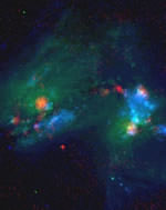
Astronomers Find a Supernova Factory

Image credit: NRAO

Using the National Science Foundation’s Very Long Baseline Array (VLBA), astronomers have discovered a recently exploded supernova 140 million light years from Earth. The supernova is in a region where two galaxies are colliding together, and furiously forming new stars. The astronomers consider this super star cluster region a “supernova factory” because a star goes off there once every two years – they’re hoping to catch more massive stars going supernova.

Using the National Science Foundation’s Very Long Baseline Array (VLBA) radio telescope, astronomers have discovered a newly-exploded star, or supernova, hidden deep in a dust-enshrouded “supernova factory” in a galaxy some 140 million light-years from Earth.

“This supernova is likely to be part of a group of super star clusters that produce one such stellar explosion every two years,” said James Ulvestad, of the National Radio Astronomy Observatory (NRAO) in Socorro, NM. “We’re extremely excited by the tremendous insights into star formation and the early Universe that we may gain by observing this ‘supernova factory,'” he added.

Ulvestad worked with Susan Neff of NASA’s Goddard Space Flight Center in Greenbelt, MD, and Stacy Teng, a graduate student at the University of Maryland, on the project. The scientists presented their findings to the American Astronomical Society’s meeting in Nashville, TN.

“These super star clusters likely are forming in much the same way that globular clusters formed in the early Universe, and thus provide us with a unique opportunity to learn about how some of the first stars formed billions of years ago,” Neff said.

The cluster is in an object called Arp 299, a pair of colliding galaxies, where regions of vigorous star formation have been found in past observations. Since 1990, four other supernova explosions have been seen optically in Arp 299.

Observations with the NSF’s Very Large Array (VLA) earlier showed a region near the nucleus of one of the colliding galaxies which had all the earmarks of prolific star formation. The astronomers focused on this region, prosaically dubbed “Source A,” with the VLBA and the NSF’s Robert C. Byrd Green Bank Telescope in 2002, and found four objects in this dusty cloud that are likely young supernova remnants. When they observed the region again in February 2003, there was a new, fifth, object located only 7 light-years from one of the previously detected objects.

More observations on April 30-May 1, 2003, showed that this new object has typical characteristics of a supernova explosion by a young, massive star.

“This supernova is exploding in a very dense environment, quite different from the environments of supernova explosions that can be seen in visible light,” Teng said. “This is the kind of dense environment in which stars likely formed in the early Universe,” she added.

The astronomers believe the super star cluster in Arp 299 saw its most recent peak of star formation some 6-8 million years ago, and now its massive stars, 10-20 times (or more) as massive as the Sun, are ending their lives in supernova explosions. Super star clusters typically contain up to a million stars, which is why the scientists think Source A will see frequent supernova explosions.

“We plan to keep watching this region, and hope that we can study numerous supernovae, and gain important new information about the processes of star formation, both in the early Universe and at the present time,” Neff said.

“Because of the dust and the distance, only a radio telescope with the VLBA’s ability to see fine detail can find the supernovae in this region,” Ulvestad said.

The VLBA is a continent-wide system of ten radio- telescope antennas, ranging from Hawaii in the west to the U.S. Virgin Islands in the east, providing the greatest resolving power, or ability to see fine detail, in astronomy. Dedicated in 1993, the VLBA is operated from the NRAO’s Array Operations Center in Socorro, New Mexico.

The VLBA has made landmark contributions to astronomy, including making the most accurate distance measurement ever made of an object beyond the Milky Way Galaxy; the first mapping of the magnetic field of a star other than the Sun; “movies” of motions in powerful cosmic jets and of distant supernova explosions; the first measurement of the propagation speed of gravity; and long-term measurements that have improved the reference frame used to map the Universe and detect tectonic motions of Earth’s continents.

Original Source: NRAO News Release

NASA Pushes Back Mars Rover Launch

NASA has decided to push back the launch of its first Mars Rover this summer to spend more time doing engineering reviews – at least three days, making the launch date no earlier than June 8. If all goes well, the first rover, MER-A will lift off on board a Delta 2 rocket and arrive at Mars on January 4, 2004. The second, MER-B will launch a few days later, and arrive on January 25. When they arrive at Mars, the twin rovers will explore the surface of the Red Planet, searching for past conditions that may have supported life.

Some Planets Could Form In Just 3 Million Years

An Earth-like planet could come together from a cloud of dust in as short as 3 million years according to a new report from researchers in Florida and Michigan. By studying the pre-planetary disks that form around other stars, the astronomers noticed that the disks form around young stars when they’re 1 million years old, but few stay longer than 3 million years, and none are present at 6 million years. This means that rocky planets, like the Earth, had to have formed during that time. Astronomers previously believed it took 10 million years for planets to form.

Malfunction Caused Rough Soyuz Landing

It turns out it was a technical malfunction, not a mistake by the crew, which caused last week’s Soyuz landing to be unexpectedly hard. Russian cosmonaut Nikolai Budarin and American astronauts Kenneth Bowersox and Donald Pettit landed 500 kilometres short of their destination in Kazakhstan on May 4th, and had a pretty rough ride. It appears the problem was a malfunction in the spacecraft’s control system, but experts in Russia haven’t been able to reproduce the problem. Investigators have called upon Russia to change the way they recover spacecraft, to position recovery aircraft and vehicles along the return path.

Europe Approves Global Navigation System

Image credit: ESA

The governments of the European Union gave their final approval for the launch of the new Galileo satellite navigation system, similar to the US-built Global Positioning System. The $3.6 billion system has had several delays to this point, but now the 30-satellite network is scheduled for completion by 2008. Consensus was reached at a meeting on Monday in Paris with the members of the European Space Agency.

The European Space Agency is now able to finalise the conditions for participation in the Galileo navigation programme and to approve the Galileo Joint Undertaking foundation act to be soon signed by ESA and the European Union.

The agreement reached among ESA member states today clears the way for the official launch of the legal entity which will have the task of coordinating ESA and EU involvement in Galileo, the European initiative to develop a global satellite navigation system.

“This is a great day for Europe in general and its space community in particular. Conscious of the economic, industrial and strategic importance of satellite navigation, our Member States have reached agreement in the common interest. We are now able to continue with Galileo, a major programme from which all citizens will benefit. Galileo is definitely a reality”, said Antonio Rodot?, ESA Director General at the end of the Council Meeting at Delegate level held in Paris today while informing German Minister of Education and Research, Mrs. Edelgard Bulmahn, Chairwoman of the ESA Council at Ministerial level to be held in Paris tomorrow.

?I am extremely delighted with this result. Galileo is now on its way . I am grateful to all ESA Member States that have striven to find a balanced solution and pleased that Europe has once again proven to be able to remain at the forefront of high level technology for a programme useful to each of us in our everyday life? said Mrs. Bulmahn when she heard the good news.

The Galileo Joint Undertaking, to be headquartered in Brussels, has a key part to play in implementing the various phases of the programme. This unique organisational structure will pave the way for the entity that will in due course operate the Galileo system. It will be responsible for the Galileo development and validation phase and also for preparations for system deployment and operations.

The founding members of the Galileo Joint Undertaking are the European Space Agency and the European Union, represented by the European Commission.

Galileo will complement the existing satellite navigation system, which presently relies entirely on GPS, the American Global Positioning System. Developed by ESA and the EU on the basis of equal co-funding, Galileo is designed to provide a complete civil system. Scheduled to be operational by 2008, it will offer the citizens of Europe and the world an accurate and secure satellite positioning capability.

A broad range of applications will be supported by the system : control of road, rail and sea traffic, synchronised data transmission between computers, and many others. Projections point to very significant economic benefits, with a return on investment of 4.6 and creation of over 140 000 jobs.

Galileo is the first instance of a project carried out jointly by the European Space Agency and the European Union.

The Galileo system will be built around 30 satellites (27 operational and 3 reserve craft) occupying three circular earth orbits, inclined at 56? to the Equator, at an altitude of 23 616 km. This configuration will provide excellent coverage of the planet. Two Galileo control centres will be established in Europe to control satellite operations and manage the navigation system.

Original Source: ESA News Release

Earthquakes Simulation Could Lead to Quake Forecasts

Image credit: NASA

NASA scientists are working on ways to predict earthquakes using an advanced computer simulation. The software is called QuakeSim, and it uses hundreds of thousands of measurements gathered by a variety of land and space-based instruments to calculate how the Earth’s crust deforms through plate tectonics. The technology is already starting to show results – one team has been able to identify regions in California with higher risks of earthquakes and predicted every magnitude 5+ quake since the year 2000 within 11 kilometres.

Advanced computer simulation tools now being developed by NASA and university researchers may soon give scientists new insights into the complex and mysterious physics of earthquakes and enable vastly improved earthquake forecasting.

Scientists at NASA?s Jet Propulsion Laboratory, Pasadena, Calif., together with NASA?s Goddard Space Flight Center, Greenbelt, Md.; Ames Research Center, Mountain View, Calif.; and several universities, are developing an advanced earthquake modeling system called QuakeSim. When completed in late 2004, QuakeSim?s simulation tools will help scientists learn more about what makes earthquakes happen.

The tools are based upon the latest technologies. For example, one uses finite element analysis, which solves complex computer modeling problems by breaking them into small pieces. For QuakeSim, the finite elements are tens to hundreds of thousands of measurements of how Earth?s crust deforms in response to movement of the giant tectonic plates Earth?s landmasses ride upon. The measurements are gathered through both ground and space-based techniques. The latter include global positioning system and interferometric synthetic aperture radar, which measure the ?quiet? (non-earthquake) motions associated with plate tectonics and the quake cycle.

QuakeSim Principal Investigator Dr. Andrea Donnellan of JPL calls QuakeSim a vital step toward eventual earthquake forecasting. ?The deformation of Earth?s crust and the interaction between quake faults is a complex 3-D process happening on timescales of minutes to thousands of years,? she said. ?Studying it requires sophisticated simulation models and high-performance supercomputers. The availability of space-based data and our current limited understanding of quake processes make this an ideal time to develop a system for studying deformation processes such as tectonics, quakes and volcanoes.?

?New quake models developed under QuakeSim are expected to yield future earthquake forecasts that will be used by a variety of federal and state agencies to develop decision support tools that will help mitigate losses from future large earthquakes,” Donnellan added.

QuakeSim?s three major simulation tools are Park, Virtual California and the Geophysical Finite Element Simulation Tool (Geofest).

Park simulates the evolution of a quake on a single, unstable fault over time. It is based upon current knowledge of the rate of movement (or ?slip?) and friction on a well-studied section of the San Andreas Fault in Parkfield, Calif., but is applicable to any fault or collection of faults. Park will be the tool of choice for researchers seeking to determine the nature and detectability of quake warning signals. It will determine how stress is distributed over a fault and how it is redistributed by quakes or ?quiet? seismic motion. It can also be used to compute the history of slip, slip speed and stress on a fault. Up to 1,024 computer processors will be used in parallel to demonstrate Park’s capability.

Virtual California simulates how California?s hundreds of independent fault segments interact and allows scientists to determine correlated patterns of activity that can be used to forecast seismic hazard, especially for quakes of magnitude 6 or greater. Patterns from the simulated data are compared to patterns in real data to strengthen understanding of the quake process. The approach’s potential is already being demonstrated. Under a joint NASA/Department of Energy study lead by Dr. John Rundle, director of the Center for Computational Science and Engineering at the University of California at Davis, Virtual California was used to identify regions of the state with elevated probabilities of quakes over the next decade. Since the study was completed in 2000, all of California’s five largest quakes of magnitude 5 or greater have occurred within 11 kilometers (6.8 miles) of these sites. The probability of this occurring randomly is about one in 100,000. The last three of these quakes occurred after the forecast map was published in the Proceedings of the National Academy of Sciences in February 2002.

Geofest creates 2-D and 3-D models of stress and strain in Earth?s crust and upper mantle in a complex geologic region with many interacting fault systems. It shows how the ground will deform in response to a quake, how deformation changes over time following a quake, and the net effects to the ground from a series of quakes. The entire Southern California system of interacting faults will be analyzed, covering a portion of the crust approximately 1,000 kilometers (621 miles) on a side. The simulation will require millions of equations and hundreds of computer processors.

In addition to JPL, the QuakeSim team includes the Davis and Irvine campuses of the University of California; Brown University, Providence, R.I.; Indiana University; and the University of Southern California. An independent review board provides oversight. Codes will be run on supercomputers at NASA?s Goddard, Ames and JPL facilities and other institutions. The California Institute of Technology in Pasadena manages JPL for NASA.

NASA’s Earth Science Enterprise is dedicated to understanding Earth as an integrated system and applying Earth system science to improve prediction of climate, weather and natural hazards using the unique vantage point of space. A primary goal of NASA’s solid Earth science program is assessment and mitigation of natural hazards. QuakeSim supports the Enterprise’s goal of developing predictive capabilities for quake hazards.

Original Source: NASA News Release

Northern Europe’s Annular Eclipse: May 31, 2003

On Saturday, May 31, an annular eclipse of the Sun will be visible from a good portion of the Northern Hemisphere. The best views will be in northern Scotland, Iceland and Greenland where the Sun will be visible as a ring of fire behind the moon, but even a partial eclipse will be visible from most of Europe, Northern Canada, the Middle East, and Asia. An annular eclipse occurs because the Moon’s orbit isn’t a perfect circle. If the Moon is at the closest part of its orbit when it passes in front of the Sun, it causes a total eclipse – at the furthest point, it’s an annular eclipse.

NASA Could Have Rescued Columbia Astronauts in Space

NASA now believes they could have launched the space shuttle Atlantis and four veteran astronauts to rescue the crew of Columbia had they realized the danger earlier. In the days after the February 1 tragedy, NASA said there was nothing that could have been done to fix Columbia’s wing, but the shuttle investigation board asked the agency to figure out what they could have done if they had known about the damage. Columbia’s 16 days of supplies could have been stretched to 30 to give time to mount a rescue mission.

China Launches Third Navigation Satellite

Chinese space officials announced on Sunday that a Long March 3-A rocket launched the third Beidou satellite, which will complete their home-grown satellite navigation system (similar to the US-built Global Positioning System). Although the system is primarily for civilian navigation, it will have military applications, and should give Chinese missiles better accuracy.

Mars Global Surveyor Snaps a Picture of Earth

Image credit: NASA

Ever wondered what the Earth would look like seen through a small telescope on Mars? Currently in orbit around the Red Planet, NASA’s Mars Global Surveyor took pictures of the Earth and Jupiter on May 8th, when they were aligned in the Martian sky. The image shows our planet in a “half-Earth” phase, and was processed so that both Earth and Moon are visible in the picture. The photograph shows Jupiter as well, including three of its brightest satellites.

What does Earth look like when viewed from Mars? At 13:00 GMT on 8 May 2003, the Mars Global Surveyor (MGS) Mars Orbiter Camera (MOC) had an opportunity to find out. In addition, a fortuitous alignment of Earth and Jupiter—the first planetary conjunction viewed from another planet—permitted the MOC to acquire an image of both of these bodies and their larger satellites. At the time, Mars and the orbiting camera were 139 million kilometers (86 million miles) from Earth and almost 1 billion kilometers (nearly 600 million miles) from Jupiter. The orbit diagram, above, shows the geometry at the time the images were obtained.

Because Jupiter is over 5 times farther from the Sun than Earth, two different exposures were needed to image the two planets. Mosaiced together, the images are shown above (top picture). The composite has been highly contrast-enhanced and “colorized” to show both planets and their satellites. The MGS MOC high resolution camera only takes grayscale (black-and-white) images; the color was derived from Mariner 10 and Cassini pictures of Earth/Moon and Jupiter, respectively, as described in the note below.

Earth/Moon: This is the first image of Earth ever taken from another planet that actually shows our home as a planetary disk. Because Earth and the Moon are closer to the Sun than Mars, they exhibit phases, just as the Moon, Venus, and Mercury do when viewed from Earth. As seen from Mars by MGS on 8 May 2003 at 13:00 GMT (6:00 AM PDT), Earth and the Moon appeared in the evening sky. The MOC Earth/Moon image has been specially processed to allow both Earth (with an apparent magnitude of -2.5) and the much darker Moon (with an apparent magnitude of +0.9) to be visible together. The bright area at the top of the image of Earth is cloud cover over central and eastern North America. Below that, a darker area includes Central America and the Gulf of Mexico. The bright feature near the center-right of the crescent Earth consists of clouds over northern South America. The image also shows the Earth-facing hemisphere of the Moon, since the Moon was on the far side of Earth as viewed from Mars. The slightly lighter tone of the lower portion of the image of the Moon results from the large and conspicuous ray system associated with the crater Tycho.

Jupiter/Galilean Satellites: When Galileo first turned his telescope toward Jupiter four centuries ago, he saw that the giant planet had four large satellites, or moons. These, the largest of dozens of moons that orbit Jupiter, later became known as the Galilean satellites. The larger two, Callisto and Ganymede, are roughly the size of the planet Mercury; the smallest, Io and Europa, are approximately the size of Earth’s Moon. This MGS MOC image, obtained from Mars orbit on 8 May 2003, shows Jupiter and three of the four Galilean satellites: Callisto, Ganymede, and Europa. At the time, Io was behind Jupiter as seen from Mars, and Jupiter’s giant red spot had rotated out of view. This image has been specially processed to show both Jupiter and its satellites, since Jupiter, at an apparent magnitude of -1.8, was much brighter than the three satellites.

Original Source: MSSS News Release