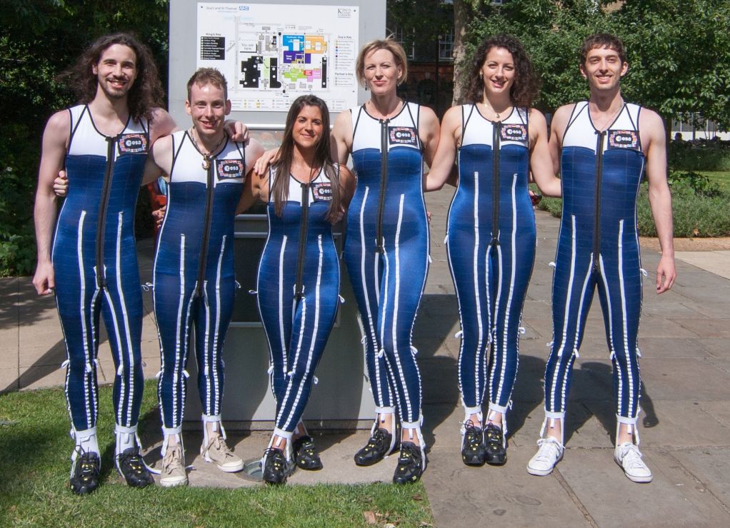
The microgravity in space makes astronauts' spines grow, and causes back pain. A new SkinSuit being developed by the ESA is helping. This image shows student test subjects wearing the suit. Image: Kings College London, Centre for Human Aerospace Physiological Sciences
The microgravity in space causes a number of problems for astronauts, including bone density loss and muscle atrophy. But there’s another problem: weightlessness allows astronauts’ spines to expand, making them taller. The height gain is permanent while they’re in space, and causes back pain.
A new SkinSuit being tested in a study at King’s College in London may bring some relief. The study has not been published yet.
The constant 24 hour microgravity that astronauts live with in space is different from the natural 24 hour cycle that humans go through on Earth. Down here, the spine goes through a natural cycle associated with sleep.
Sleeping in a supine position allows the discs in the spine to expand with fluid. When we wake up in the morning, we’re at our tallest. As we go about our day, gravity compresses the spinal discs and we lose about 1.5 cm (0.6 inches) in height. Then we sleep again, and the spine expands again. But in space, astronauts spines have been known to grow up to 7 cm. (2.75 in.)
Study leader David A. Green explains it: “On Earth your spine is compressed by gravity as you’re on your feet, then you go to bed at night and your spine unloads – it’s a normal cyclic process.”
In microgravity, the spine of an astronaut is never compressed by gravity, and stays unloaded. The resulting expansion causes pain. As Green says, “In space there’s no gravitational loading. Thus the discs in your spine may continue to swell, the natural curves of the spine may be reduced and the supporting ligaments and muscles — no longer required to resist gravity – may become loose and weak.”
The SkinSuit being developed by the Space Medicine Office of ESA’s European Astronaut Centre and the King’s College in London is based on work done by the Massachusetts Institute of Technology (MIT). It’s a spandex-based garment that simulates gravity by squeezing the body from the shoulders to the feet.
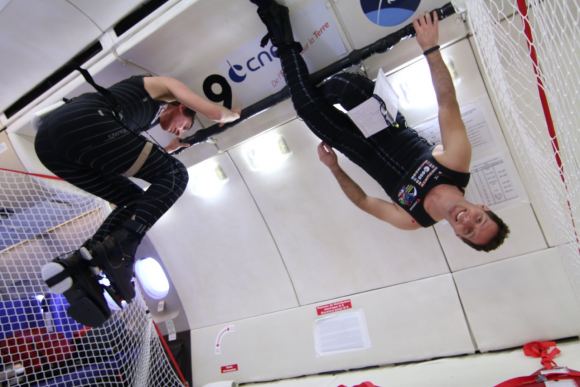
ESA astronauts have tested the SkinSuit both in weightless parabolic flights, and on-board the ISS. Image: CNES/Novespace, 2014
The Skinsuits were tested on-board the International Space Station by ESA astronauts Andreas Mogensen and Thomas Pesquet. But they could only be worn for a short period of time. “The first concepts were really uncomfortable, providing some 80% equivalent gravity loading, and so could only be worn for a couple of hours,” said researcher Philip Carvil.
Back on Earth, the researchers worked on the suit to improve it. They used a waterbed half-filled with water rich in magnesium salts. This re-created the microgravity that astronauts face in space. The researchers were inspired by the Dead Sea, where the high salt content allows swimmers to float on the surface.
“During our longer trials we’ve seen similar increases in stature to those experienced in orbit, which suggests it is a valid representation of microgravity in terms of the effects on the spine,” explains researcher Philip Carvil.
The SkinSuit has evolved through several designs to make it more wearable, comfortable, and effective. Image: Kings College London/Philip Carvill
Studies using students as test subjects have helped with the development of the SkinSuit. After lying on the microgravity-simulating waterbed both with and without the SkinSuit, subjects were scanned with MRI’s to test the SkinSuit’s effectiveness. The suit has gone through several design revisions to make it more comfortable, wearable, and effective. It’s now up to the Mark VI design.
“The Mark VI Skinsuit is extremely comfortable, to the point where it can be worn unobtrusively for long periods of normal activity or while sleeping,” say Carvil. “The Mk VI provides around 20% loading – slightly more than lunar gravity, which is enough to bring back forces similar to those that the spine is used to having.”
“The results have yet to be published, but it does look like the Mk VI Skinsuit is effective in mitigating spine lengthening,” says Philip. “In addition we’re learning more about the fundamental physiological processes involved, and the importance of reloading the spine for everyone.”
This image shows the incredibly distant and ancient supernova DES16C2nm. The supernova was discovered by the Dark Energy Survey. Image: Mat Smith and DES collaboration.
Astronomers have discovered the most distant supernova yet, at a distance of 10.5 billion light years from Earth. The supernova, named DES16C2nm, is a cataclysmic explosion that signaled the end of a massive star some 10.5 billion years ago. Only now is the light reaching us. The team of astronomers behind the discovery have published their results in a new paper available at arXiv.
“…sometimes you just have to go out and look up to find something amazing.” – Dr. Bob Nichol, University of Portsmouth.
The supernova was discovered by astronomers involved with the Dark Energy Survey (DES), a collaboration of astronomers in different countries. The DES’s job is to map several hundred million galaxies, to help us find out more about dark energy. Dark Energy is the mysterious force that we think is causing the accelerated expansion of the Universe.
DES16C2nm was first detected in August 2016. Its distance and extreme brightness were confirmed in October that year with three of our most powerful telescopes – the Very Large Telescope and the Magellan Telescope in Chile, and the Keck Observatory, in Hawaii.
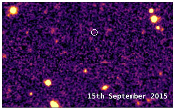
This image from 2015 shows the same area of sky before DES16C2nm exploded. Image: Mat Smith and DES collaboration.
DES16C2nm is what’s known as a superluminous supernova (SLSN), a type of supernova only discovered 10 years ago. SLSNs are the rarest—and the brightest—type of supernova that we know of. After the supernova exploded, it left behind a neutron star, which is the densest type of object in the universe. The extreme brightness of SLSNs, which can be 100 times brighter than other supernovae, are thought to be caused by material falling into the neutron star.
“It’s thrilling to be part of the survey that has discovered the oldest known supernova.” – Dr Mathew Smith, lead author, University of Southampton
Lead author of the study Dr Mathew Smith, of the University of Southampton, said: “It’s thrilling to be part of the survey that has discovered the oldest known supernova. DES16C2nm is extremely distant, extremely bright, and extremely rare – not the sort of thing you stumble across every day as an astronomer.”
Dr. Smith went on to say that not only is the discovery exciting just for being so distant, ancient, and rare. It’s also providing insights into the cause of SLSNs: “The ultraviolet light from SLSN informs us of the amount of metal produced in the explosion and the temperature of the explosion itself, both of which are key to understanding what causes and drives these cosmic explosions.”
“Now we know how to find these objects at even greater distances, we are actively looking for more of them as part of the Dark Energy Survey.” – Co-author Mark Sullivan, University of Southampton.
Now that the international team behind the Dark Energy Survey has found one of the SLSNs, they want to find more. Co-author Mark Sullivan, also of the University of Southampton, said: “Finding more distant events, to determine the variety and sheer number of these events, is the next step. Now we know how to find these objects at even greater distances, we are actively looking for more of them as part of the Dark Energy Survey.”
The instrument used by DES is the newly constructed Dark Energy Camera (DECam), which is mounted on the Victor M. Blanco 4-meter Telescope at the Cerro Tololo Inter-American Observatory (CTIO) in the Chilean Andes. DECam is an extremely sensitive 570-megapixel digital camera designed and built just for the Dark Energy Survey.
The DECam in operation at its home in the Chilean Andes. The extremely sensitive, 570 megapixel camera is mounted on the Victor M. Blanco 4-meter Telescope at the Cerro Tololo Inter-American Observatory. Image: DES/CTIO
The Dark Energy Survey involves more than 400 scientists from over 40 international institutions. It began in 2013, and will wrap up its five year mission sometime in 2018. The DES is using 525 nights of observation to carry out a deep, wide-area survey to record information from 300 million galaxies that are billions of light-years from Earth. DES is designed to help us answer a burning question.
According to Einstein’s General Relativity Theory, gravity should be causing the expansion of the universe to slow down. And we thought it was, until 1998 when astronomers studying distant supernovae found that the opposite is true. For some reason, the expansion is speeding up. There are really only two ways of explaining this. Either the theory of General Relativity needs to be replaced, or a large portion of the universe—about 70%—consists of something exotic that we’re calling Dark Energy. And this Dark Energy exerts a force opposite to the attractive force exerted by “normal” matter, causing the expansion of the universe to accelerate.
“…sometimes you just have to go out and look up to find something amazing.” – Dr. Bob Nichol, University of Portsmouth.
To help answer this question, the DES is imaging 5,000 square degrees of the southern sky in five optical filters to obtain detailed information about each of the 300 million galaxies. A small amount of the survey time is also used to observe smaller patches of sky once a week or so, to discover and study thousands of supernovae and other astrophysical transients. And this is how DES16C2nm was discovered.
Study co-author Bob Nichol, Professor of Astrophysics and Director of the Institute of Cosmology and Gravitation at the University of Portsmouth, commented: “Such supernovae were not thought of when we started DES over a decade ago. Such discoveries show the importance of empirical science; sometimes you just have to go out and look up to find something amazing.”
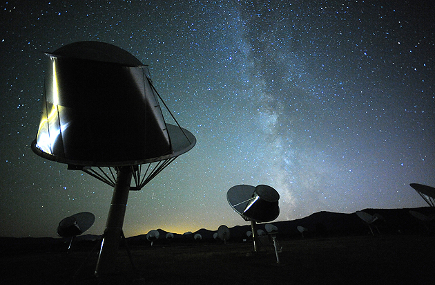
The Search for Extraterrestrial Intelligence (SETI) listens for radio signals from other civilizations. In this image, radio-telescopes in SETI's Allen Telescope Array (ATA) are hard at work with the Milky Way in the background. Image: SETI
The discovery of alien life is one of those things that everyone thinks about at some point. Hollywood has made their version of first contact very clear: huge alien vessels appear over Earth’s cities, panic ensues, and Will Smith saves the day with a Windows 3.1 virus. It’s lots of fun—and who knows?—it may end up being accurate. (Not the Windows 3.1 part.) But sci-fi books and movies aside, what do we really know about our attitude to the discovery of alien life?
We have an organization (SETI) dedicated to detecting the presence of alien civilizations, and we have a prominent scientist (Stephen Hawking) warning against advertising our own presence. Those represent the extremes—actively seeking out alien life vs. hiding from it—but what is the collective attitude towards the discovery of alien life? Scientists at Arizona State University (ASU) have studied that issue and detailed their results in a new study published in the journal Frontiers of Psychology.
The team of scientists tried to gauge people’s reactions to the discovery of alien life in three separate parts of their study. In the first case, they examined media reports of past announcements about the discovery of alien life, for example the announcement in 1996 that evidence of microbial life had been found in a Martian metorite.
Secondly, they asked a sample of over 500 people what their own reactions, and the reactions of the rest of humanity, would be to the hypothetical announcement of alien life.
Thirdly, the 500 people were split into two groups. Half were asked to read and respond to a real newspaper story announcing the discovery of fossilized Martian microbial life. The other half were asked to read and respond to a newspaper article announcing the creation of synthetic life by Craig Venter.
Martian meteorite ALH84001 was found in Antarctica in 1984 by a group of meteorite hunters from the US. Scientists who studied it suggested that it contained evidence of ancient Martian microbial life. Image: By Jstuby at English Wikipedia, CC BY-SA 3.0, https://commons.wikimedia.org/w/index.php?curid=47556214
In all three cases the life was microbial in nature. Microbial life is the simplest life form, so it should be what we expect to find. This is certainly true in our own Solar System, since the existence of any other intelligent life has been ruled out here, while microbial life has not.
Also, in all three cases, the language of the respondents and the language in the media reports was analyzed for positive and negative words. A specialized piece of software called Linguistic Inquiry and Word Count (LIWC) was used. It’s text-analysis software that scans written language and identifies instances of words that reflect positive affect, negative affect, reward, or risk. (You can try LIWC here for fun, if you like.)
Electron microscope images of the Martian meteorite ALH84001 showed chain-like structures that resembled living structures. Image: NASA
Analyzing Media Reports
The media reports used in the study were all from what the team considers reputable journalism outlets like The New York Times and Science Magazine. The reports were about things like unidentified signals from space that could have been alien in nature, fossilized microbial remains in meteorites, and the discovery of exoplanets in the habitable zones of other solar systems. There were 15 articles in total.
The authors of the study wanted to find out how people would react to the discovery of alien life, and to the discovery of potentially habitable exoplanets which might harbor life. In this artist’s illustration, exoplanets orbit a young, red dwarf star. Credit: NASA/JPL-Caltec
Overall, the study showed that language in media reports about alien life was more positive than negative, and emphasized reward rather than risk. So people generally find the potential of alien life to be a positive thing and something to be looked forward to. However, this part of the study showed something else: People were more positively disposed towards news of alien life that was microbial than they were towards alien life that could be present on exoplanets, where, presumably, it might be more than merely microbial. So, microbes we can handle, but something more advanced and a little doubt starts to creep in.
Reactions to Hypothetical Announcements of Alien Life
This part of the study aimed to assess people’s beliefs regarding how both they as individuals—and humanity as a whole—might react to the discovery of alien microbial life. The same LIWC software was used to analyze the written responses of the 500 people in the sample group.
The results were similar to the first part of the study, at least for the individuals themselves. Positive affect was more predominant than negative aspect, and words reflecting reward were more predominant than words reflecting risk. This probably isn’t surprising, but the study did show something more interesting.
When participants were asked about how the rest of humanity would respond to the announcement of alien life, the response was different. While positive language still outweighed negative language, and reward still outweighed risk, the differences weren’t as pronounced as they were for individuals. So people seem to think that others won’t be looking forward to the discovery of alien life as much as they themselves do.
Actual Reactions to the Discovery of Extraterrestrial Life
This is hard to measure since we haven’t actually discovered any yet. But there have been times when we thought we might have.
In this part of the study, the group of 500 respondents was split into two groups of 250. The first was asked to read an actual 1996 New York Times article announcing the discovery of fossilized microbes in the Martian meteorite. The second group was asked to read a New York Times article from 2010 announcing the creation of life by Craig Venter. The goal was to find out if the positive bias towards the discovery of microbial life was specific to microbial life, or to scientific advancements overall.
Saturn’s moon Enceladus could harbor microbial life in the warm salty water thought to exist under its frozen surface. Respondents in the study seemed to like that possibility. Credits: NASA/JPL-Caltech/Space Science Institute
This part of the study found the same emphasis on positive affect over negative affect, and reward over risk. This held true in both cases: the Martian microbial life article, and the artificially created life article. The type of article played a minor role in people’s responses. Results were slightly more positive towards the Martian life story than the artificial life story.
Overall, this study shows that people seem positively disposed towards the discovery of alien life. This is reflected in media coverage, people’s personal responses, and people’s expectations of how others would react.
This is really just the tip of the iceberg, though. As the authors say in their study, this is the first empirical attempt to understand any of this. And the study was only 500 people, all Americans.
How different the results might be in other countries and cultures is still an open question. Would populations whose attitudes are more strongly shaped by religion respond differently? Would the populations of countries that have been invaded and dominated by other countries be more nervous about alien life or habitable exoplanets? There’s only conjecture at this point.
Maybe we’re novelty-seekers and we thrive on new discoveries. Or maybe we’re truth-seekers, and that’s reflected in the study. Maybe some of the positivity reflects our fear of being alone. If Earth is the only life-supporting world, that’s a very lonely proposition. Not only that, but it’s an awesome responsibility: we better not screw it up!
Still, the results are encouraging for humanity. We seem, at least according to this first study, open to the discovery of alien life.
But that might change when the first alien ship casts its shadow over Los Angeles.
Jupiter's prominent storm, the Great Red Spot, is held in place by the alternating storm bands in Jupiter's atmosphere. Image: By NASA, ESA, and A. Simon (Goddard Space Flight Center) [Public domain], via Wikimedia Commons
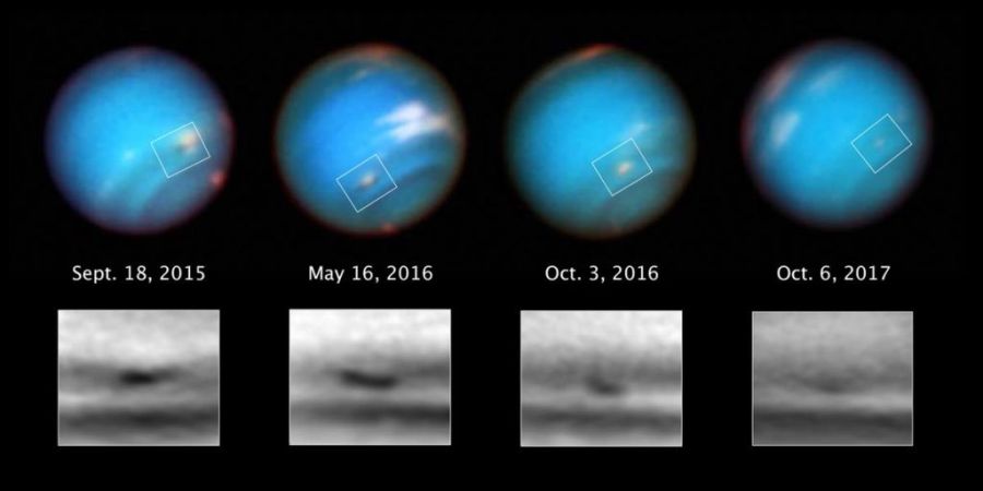
Back in the late 1980’s, Voyager 2 was the first spacecraft to capture images of the giant storms in Neptune’s atmosphere. Before then, little was known about the deep winds cycling through Neptune’s atmosphere. But Hubble has been turning its sharp eye towards Neptune over the years to study these storms, and over the past couple of years, it’s watched one enormous storm petering out of existence.
“It looks like we’re capturing the demise of this dark vortex, and it’s different from what well-known studies led us to expect.” – Michael H. Wong, University of California at Berkeley.
When we think of storms on the other planets in our Solar System, we automatically think of Jupiter. Jupiter’s Great Red Spot is a fixture in our Solar System, and has lasted 200 years or more. But the storms on Neptune are different: they’re transient.
Voyager 2 captured this image of Neptune in 1982, when it was over 7 million km (4.4 million miles) away from the planet. The Great Dark Spot in the middle of the image was the first storm ever seen on Neptune. Image: By NASA (JPL image) [Public domain], via Wikimedia Commons
The storm on Neptune moves in an anti-cyclonic direction, and if it were on Earth, it would span from Boston to Portugal. Neptune has a much deeper atmosphere than Earth—in fact it’s all atmosphere—and this storm brings up material from deep inside. This gives scientists a chance to study the depths of Neptune’s atmosphere without sending a spacecraft there.
The first question facing scientists is ‘What is the storm made of?’ The best candidate is a chemical called hydrogen sulfide (H2S). H2S is a toxic chemical that stinks like rotten eggs. But particles of H2S are not actually dark, they’re reflective. Joshua Tollefson from the University of California at Berkeley, explains: “The particles themselves are still highly reflective; they are just slightly darker than the particles in the surrounding atmosphere.”
“We have no evidence of how these vortices are formed or how fast they rotate.” – Agustín Sánchez-Lavega, University of the Basque Country in Spain.
But beyond guessing what chemical the spot might me made of, scientists don’t know much else. “We have no evidence of how these vortices are formed or how fast they rotate,” said Agustín Sánchez-Lavega from the University of the Basque Country in Spain. “It is most likely that they arise from an instability in the sheared eastward and westward winds.”
There’ve been predictions about how storms on Neptune should behave, based on work done in the past. The expectation was that storms like this would drift toward the equator, then break up in a burst of activity. But this dark storm is on its own path, and is defying expectations.
“We thought that once the vortex got too close to the equator, it would break up and perhaps create a spectacular outburst of cloud activity.” – Michael H. Wong, University of California at Berkeley.
“It looks like we’re capturing the demise of this dark vortex, and it’s different from what well-known studies led us to expect,” said Michael H. Wong of the University of California at Berkeley, referring to work by Ray LeBeau (now at St. Louis University) and Tim Dowling’s team at the University of Louisville. “Their dynamical simulations said that anticyclones under Neptune’s wind shear would probably drift toward the equator. We thought that once the vortex got too close to the equator, it would break up and perhaps create a spectacular outburst of cloud activity.”
Rather than going out in some kind of notable burst of activity, this storm is just fading away. And it’s also not drifting toward the equator as expected, but is making its way toward the south pole. Again, the inevitable comparison is with Jupiter’s Great Red Spot (GRS).
The GRS is held in place by the prominent storm bands in Jupiter’s atmosphere. And those bands move in alternating directions, constraining the movement of the GRS. Neptune doesn’t have those bands, so it’s thought that storms on Neptune would tend to drift to the equator, rather than toward the south pole.
Jupiter’s prominent storm, the Great Red Spot, is held in place by the alternating storm bands in Jupiter’s atmosphere. Image: By NASA, ESA, and A. Simon (Goddard Space Flight Center) [Public domain], via Wikimedia Commons
This isn’t the first time that Hubble has been keeping an eye on Neptune’s storms. The Space Telescope has also looked at storms on Neptune in 1994 and 1996. The video below tells the story of Hubble’s storm watching mission.
The images of Neptune’s storms are from the Hubble Outer Planets Atmosphere Legacy (OPAL) program. OPAL gathers long-term baseline images of the outer planets to help us understand the evolution and atmospheres of the gas giants. Images of Jupiter, Saturn, Uranus and Neptune are being taken with a variety of filters to form a kind of time-lapse database of atmospheric activity on the four gas planets.
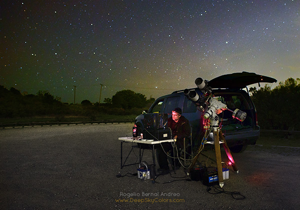
Astrophotographer Rogelio Vernal Andreo with his gear all set up. His rig is a complex set up, including dual Takahashi telescopes photographing the same part of the sky simultaneously. Image; Rogelio Bernal Andreo (DeepSkyColors.com) (CC BY-NC-ND 3.0)
An astrophotographer in California has captured images of Elon Musk’s Tesla Roadster on its journey around our Sun. In the early morning of February 9th, Rogelio Bernal Andreo captured images of the Roadster as it appeared just above the horizon. To get the images, Andreo made use of an impressive arsenal of technological tools.
Andreo knew that photographing the Roadster would be a challenge, since it was over a million miles away at the time. But he has the experience and equipment to pull it off. The first task was to determine where the Tesla would be in the sky. Luckily, NASA’s JPL creates lists of coordinates for objects in the sky, called ephemerides. Andreo found the ephemeris for Starman and the Roadster, and it showed that the pair would be in the Hydra constellation, and that they would be only about 20 degrees above the horizon. That’s a challenge, because it means photographing through more atmospheric density.
The Tesla Roadster and its pilot “Starman” leaving Earth behind. Image: SpaceX
However, the Roadster and its driver would be bright enough to do it. As Andreo says in his blog, “The ephemeris from the JPL also indicated that the Roadster’s brightness would be at magnitude 17.5, and I knew that’s perfectly achievable.” So he gathered his gear, hopped in his vehicle, and went for it.
Andreo’s destination was the Monte Bello Open Space Preserve, a controlled-access area for which he has a night-time use permit. This area is kind of close to the San Francisco Bay Area, so the sky is a little bright for astrophotography, but since the Roadster has a magnitude of 17.5, he thought it was doable. Plus, it’s a short drive from his home.
Once he arrived there, he set up his impressive array of gear: dual telescopes and cameras, along with a tracking telescope and computers running specialized software. Andreo explains it best:
“Let me give you a brief description of my gear – also the one I use for most of my deep-sky images. I have a dual telescope system: two identical telescopes and cameras in parallel, shooting simultaneously at the very same area of the sky – same FOV, save a few pixels. The telescopes are Takahashi FSQ106EDX. Their aperture is 106mm (about 4″) and they give you a native 530mm focal length at f/5. The cameras are SBIG STL11k monochrome CCD cameras, one of the most legendary full-frame CCD cameras for astronomy (not the best one today, mind you, but still pretty decent). All this gear sits on a Takahashi EM-400 mount, the beast that will move it at hair-thin precision during the long exposures. I brought the temperature of the CCD sensors to -20C degrees (-4F) using the CCD’s internal cooling system.”
CCD’s with internal cooling systems. Very impressive!
The Takahashi FSQ106. Two of these beasts are at the heart of Andreo’s astrophotography system. Image: Takahashi Telescopes
Andreo uses a specialized focusing system to get his images. He uses focusers from Robofocus and precision focusing software called FocusMax. He also uses a third, smaller telescope called an autoguider. It focuses on a single star in the Field of View and follows it religiously. When that star moves, the whole rig moves. As Andreo says on his blog, “Autoguiding provides a much better mount movement than tracking, which is leaving up to the mount to blindly “follow” the sky. By actually “following” a star, we can make sure there’ll be no trails whether our exposures are 2 or 30 minutes long.”
Once he was all set up, there was time pressure. The Roadster would only be above the horizon for a short time and the Moon was coming up and threatening to wash out the sky. Andreo got going, but his first shots showed nothing.
Where the Roadster should be, Andreo’s photos showed nothing. But he wasn’t deterred. Image: Rogelio Bernal Andreo, (DeepSkyColor.com) (CC BY-NC-ND 3.0)
Andreo felt that once he got home and could process the images properly, the Tesla Roadster and its driver would be somewhere in his images. He kept taking pictures until about 5 AM. Cold and tired, he finally packed up his gear and went home.
“…no matter what I did, I could not find the Roadster.” Astrophotographer Rogelio Bernal Andreo
After some sleep, he began working with his images. “After a few hours of sleep, I started playing with the data and no matter what I did, I could not find the Roadster. I kept checking the coordinates, nothing made sense. So I decided to try again. The only difference would be that this time the Moon would rise around 3:30am, so I could try star imaging at 2:30am and get one hour of Moon-free skies, maybe that would help.”
Rogelio Bernal Andreo is a very accomplished astrophotographer. His images have been chosen as NASA’s Astronomy Photo of the Day over 50 times. This close-up of the Orion Nebula was chosen as APOD on June 4, 2017. The three bright stars are Orion’s belt. Image: Rogelio Bernal Andreo (DeepSkyColors.com) (CC BY-NC-ND 3.0)
So Andreo set out to capture the Roadster again. The next night, at the same location, he set up his gear again. But this time, some clouds rolled in, and Andreo got discouraged. He stayed to wait for the sky to improve, but it didn’t. By about 4 AM he packed up and headed home.
After a nap, he went over his photos, but still couldn’t find the Roadster. It was a puzzle, because he knew the Roadster’s coordinates. Andreo is no rookie, his photos have been published many times in Astronomy Magazine, Sky and Telescope, National Geographic, and other places. His work has also been chosen as NASA’s APOD (Astronomy Picture of the Day) more than 50 times. So when he can’t find something in his images that should be there, it’s puzzling.
Then he had an A-HA! moment:
“Then it hit me!! When I created the ephemeris from the JPL’s website, I did not enter my coordinates!! I went with the default, whatever that might be! Since the Roadster is still fairly close to us, parallax is significant, meaning, different locations on Earth will see Starman at slightly different coordinates. I quickly recalculate, get the new coordinates, go to my images and thanks to the wide field captured by my telescopes… boom!! There it was!! Impossible to miss!! It had been right there all along, I just never noticed!”
Andreo is clearly a dedicated astrophotographer, and this is a neat victory for him. He deserves a tip of the hat from space fans. Why not check out his website—his gallery is amazing!—and share a comment with him.
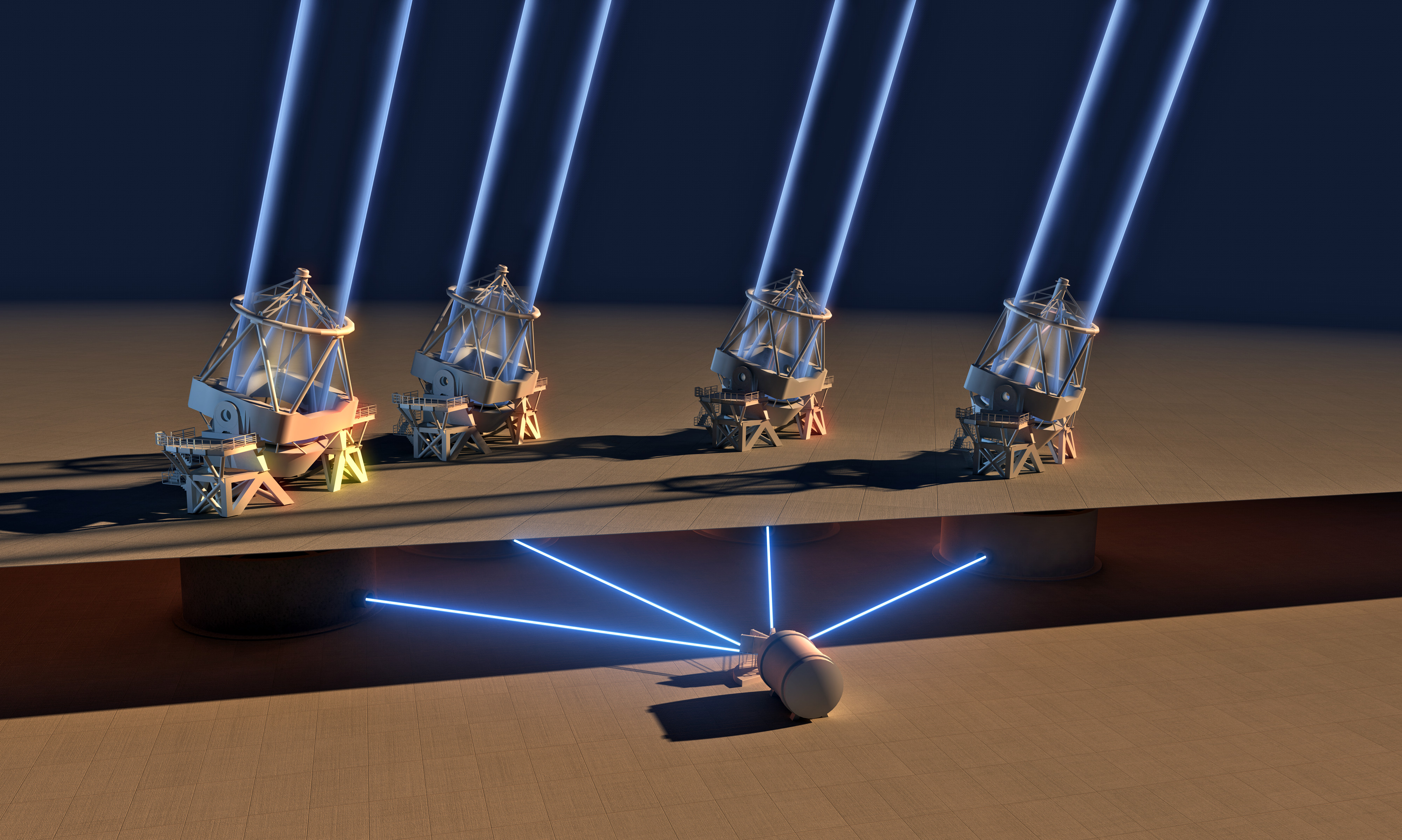
The ESPRESSO (Echelle SPectrograph for Rocky Exoplanet and Stable Spectroscopic Observations) instrument collects the light from all four of the 8.2-metre telescopes of the ESO's Very Large Telescope in Chile. The combined light-collecting area makes it the largest optical telescope in existence. Image: ESO/L. Calcada
It’s been 20 years since the first of the four Unit Telescopes that comprise the ESO’s Very Large Telescope (VLT) saw first light. Since the year 2000 all four of them have been in operation. One of the original goals of the VLT was to have all four of the ‘scopes work in combination, and that has now been achieved.
The instrument that combines the light from all four of the VLT ‘scopes is called ESPRESSO, which stands for Echelle SPectrograph for Rocky Exoplanet and Stable Spectroscopic Observations. ESPRESSO captures the light from each of the 8.2 meter mirrors in the four Unit Telescopes of the VLT. That combination makes ESPRESSO, in effect, the largest optical telescope in the world.
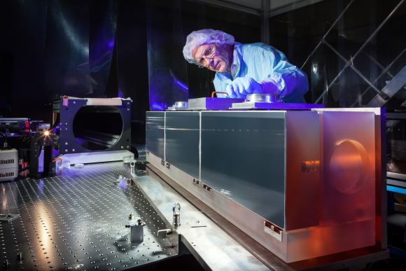
The huge diffraction grating is at the heart of the ultra-precise ESPRESSO spectrograph. In this image, the diffraction grating is undergoing testing in the cleanroom at ESO Headquarters in Garching bei München, Germany. Image: ESO/M. Zamani
Combining the power of the four Unit Telescopes of the VLT is a huge milestone for the ESO. As ESPRESSO instrument scientist at ESO, Gaspare Lo Curto, says, “ESO has realised a dream that dates back to the time when the VLT was conceived in the 1980s: bringing the light from all four Unit Telescopes on Cerro Paranal together at an incoherent focus to feed a single instrument!” The excitement is real, because along with its other science goals, ESPRESSO will be an extremely powerful planet-hunting telescope.
“ESO has realised a dream that dates back to the time when the VLT was conceived in the 1980s.” – Gaspare Lo Curto, ESPRESSO instrument scientist.
ESPRESSO uses a system of mirrors, lenses, and prisms to transmit the light from each of the four VLT ‘scopes to the spectrograph. This is accomplished with a network of tunnels that was incorporated into the VLT when it was built. ESPRESSO has the flexibility to combine the light from all four, or from any one of the telescopes. This observational flexibility was also an original design goal for ESPRESSO.
The four Unit Telescopes often operate together as the VLT Interferometer, but that’s much different than ESPRESSO. The VLT Interferometer allows astronomers to study extreme detail in bright objects, but it doesn’t combine the light from the four Unit Telescopes into one instrument. ESPRESSO collects the light from all four ‘scopes and splits it into its component colors. This allows detailed analysis of the composition of distant objects.
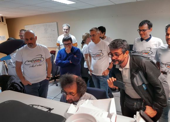
ESPRESSO team members gather in the control room during ESPRESSO’s first light. Image: ESO/D. Megevand
ESPRESSO is a very complex instrument, which explains why it’s taken until now to be implemented. It works with a principle called “incoherent focus.” In this sense, “incoherent” means that the light from all four telescopes is added together, but the phase information isn’t included as it is with the VLT Interferometer. What this boils down to is that while both the VLT Interferometer and ESPRESSO both use the light of all four VLT telescopes, ESPRESSO only has the spatial resolution of a single 8.2 mirror. ESPRESSO, as its name implies, is all about detailed spectrographic analysis. And in that, it will excel.
“ESPRESSO working with all four Unit Telescopes gives us an enticing foretaste of what the next generation of telescopes, such as ESO’s Extremely Large Telescope, will offer in a few years.” – ESO’s Director General, Xavier Barcons
ESPRESSO is the successor to HARPS, the High Accuracy Radial velocity Planet Searcher, which up until now has been our best exoplanet hunter. HARPS is a 3.6 meter telescope operated by the ESO, and also based on an echelle spectrograph. But the power of ESPRESSO will dwarf that of HARPS.
There are three main science goals for ESPRESSO:
Planet Hunting
Measuring the Variation of the Fundamental Physical Constants
Analyzing the Chemical Composition of Stars in Nearby Galaxies
Planet Hunting
ESPRESSO will take highly precise measurements of the radial velocities of solar type stars in other solar systems. As an exoplanet orbits its star, it takes part in a dance or tug-of-war with the star, the same way planets in our Solar System do with our Sun. ESPRESSO will be able to measure very small “dances”, which means it will be able to detect very small planets. Right now, our planet-hunting instruments aren’t as sensitive as ESPRESSO, which means our exoplanet search results are biased to larger planets. ESPRESSO should detect more smaller, Earth-size planets.
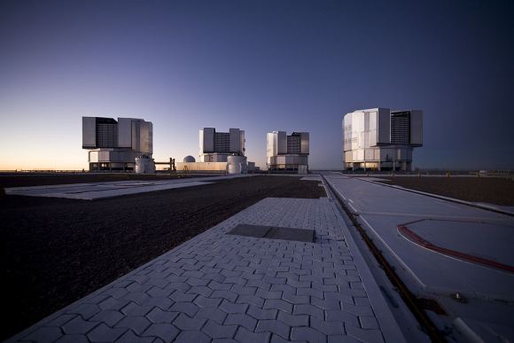
The four Unit Telescopes that make up the ESO’s Very Large Telescope, at the Paranal Observatory> Image: By ESO/H.H.Heyer [CC BY 4.0 (http://creativecommons.org/licenses/by/4.0)], via Wikimedia Commons
Measuring the Variation of the Fundamental Physical Constants
This is where the light-combining power of ESPRESSO will be most useful. ESPRESSO will be used to observe extremely distant and faint quasars, to try and measure the variation of the fundamental physical constants in our Universe. (If there are any variations, that is.) It’s not only the instrument’s light-combining capability that allows this, but also the instrument’s extreme stability.
Specifically, the ESPRESSO will try to take our most accurate measurements yet of the fine structure constant, and the proton to electron mass ratio. Astronomers want to know if these have changed over time. They will use ESPRESSO to examine the ancient light from these distant quasars to measure any change.
Analyzing the Chemical Composition of Stars in Nearby Galaxies
ESPRESSO will open up new possibilities in the measurement of stars in nearby galaxies. It’s high efficiency and high resolution will allow astronomers to study stars outside of the Milky Way in unprecedented detail. A better understanding of stars in other galaxies is always a priority item in astronomy.
We’ll let Project Scientist Paolo Molaro have the last word, for now. “This impressive milestone is the culmination of work by a large team of scientists and engineers over many years. It is wonderful to see ESPRESSO working with all four Unit Telescopes and I look forward to the exciting science results to come.”
A look inside the cavernous cargo hold of the C5 aircraft that carried the James Webb to California. Image: NASA/Chris Gunn
The two halves of the James Webb Space Telescope are now in the same location and ready to take the next step on JWST’s journey. On February 2nd, Webb’s Optical Telescope and Integrated Science instrument module (OTIS) arrived at Northrop Grumman Aerospace Systems in Redondo Beach, California. The integrated spacecraft, consisting of the spacecraft bus and sunshield, were already there, waiting for OTIS so they could join together and become a complete spacecraft.
“The team will begin the final stages of integration of the world’s largest space telescope.” – Scott Willoughby, Northrop Grumman’s Program Manage for the JWST.
“It’s exciting to have both halves of the Webb observatory – OTIS and the integrated spacecraft element – here at our campus,” said Scott Willoughby, vice president and program manager for Webb at Northrop Grumman. “The team will begin the final stages of integration of the world’s largest space telescope.”
The Space Telescope for Air, Road, and Sea (STTARS) is a custom-designed container that holds the James Webb’s Optical Telescope and Integrated Science (OTIS) instrument module. In this image its being unloaded from a U.S. military C-5 Charlie aircraft at Los Angeles International Airport (LAX) on Feb. 2, 2018. Image: NASA/Chris Gunn
OTIS arrived from the Johnson Space Center in Houston, where it had successfully completed its cryogenic testing. To prepare for that journey, OTIS was placed inside a custom shipping container designed to protect the delicate and expensive Webb Telescope from any damage. That specially designed container is called the Space Telescope Transporter for Air, Road and Sea (STTARS).
STTARS is a massive container, measuring 4.6 meters (15 feet) wide, 5.2 meters (17 feet) tall, and 33.5 meters feet (110) long, and weighing approximately 75,000 kilograms (almost 165,000 pounds). It’s much larger than the James Webb itself, but even then, the primary mirror wings and the secondary mirror tripod must be folded into flight configuration in order to fit.
The Space Telescope Transporter for Air, Road and Sea (STTARS) NASA’s at Johnson Space Center in Houston. Image: NASA/Chris Gunn
The next step for the JWST is to join the spacecraft itself with OTIS. Once that happens, JWST will be complete and fully integrated. Then there’ll be more tests called observatory-level testing. After that, another journey inside STTARS to Kouru, French Guiana, where the JWST will be launched in 2019.
“This is a major milestone.” – Eric Smith, director of the James Webb Space Telescope Program at NASA.
“This is a major milestone,” said Eric Smith, director of the James Webb Space Telescope Program at NASA. “The Webb observatory, which is the work of thousands of scientists and engineers across the globe, will be carefully tested to ensure it is ready to launch and enable scientists to seek the first luminous objects in the universe and search for signs of habitable planets.”
You can’t fault people, either NASA personnel or the rest of us, for getting excited about each development in the James Webb Space Telescope story. Every time the thing twitches or moves, our excitement re-spawns. It seems like everything that happens with the JWST is now a milestone in its long, uncertain journey. It’s easy to see why.
The Space Telescope That Almost Wasn’t
The James Webb ran into a lot of problems during its development. As can be expected for a ground-breaking, technology-pushing project like the Webb, it’s expensive. In 2011, when the project was well underway, it was revealed that the Webb would cost $8.8 billion, much more than the initial budget of $1.6 billion. The House of Representatives cancelled the project, then restored it, though funding was capped at $8 billion.
That was the main hurdle facing the development of the JWST, but there were others, including timeline delays. The most recent timeline change moved the launch date from 2017 to Spring 2019. As of now, the James Webb is on schedule, and on target to meet its revised budget.
The First “Super Telescope”
The JWST is the first of the “Super Telescopes” to be in operation. Once it’s in place at LaGrange Point 2 (L2), about 1.5 million km (930,000 miles) from Earth, it will begin observing, primarily in infrared. It will surpass both the Hubble Telescope and the Spitzer Telescope, and will “look back in time” to some of oldest stars and galaxies in the universe. It will also examine exoplanets and contribute to the search for life.
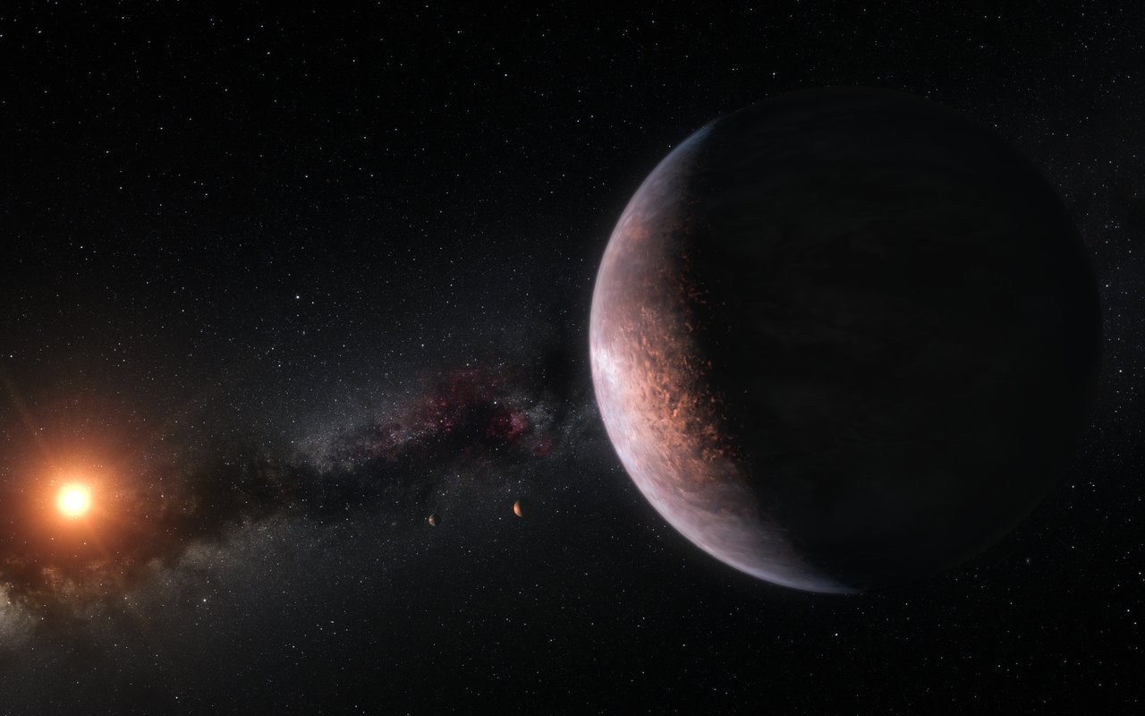
This artist’s impression shows several of the planets orbiting the ultra-cool red dwarf star TRAPPIST-1. New observations and analysis have yielded good estimates of the densities of all seven of the Earth-sized planets and suggest that they are rich in volatile materials, probably water. Image Credit: ESO
When we finally find life somewhere out there beyond Earth, it’ll be at the end of a long search. Life probably won’t announce its presence to us, we’ll have to follow a long chain of clues to find it. Like scientists keep telling us, at the start of that chain of clues is water.
The discovery of the TRAPPIST-1 system last year generated a lot of excitement. 7 planets orbiting the star TRAPPIST-1, only 40 light years from Earth. At the time, astronomers thought at least some of them were Earth-like. But now a new study shows that some of the planets could hold more water than Earth. About 250 times more.
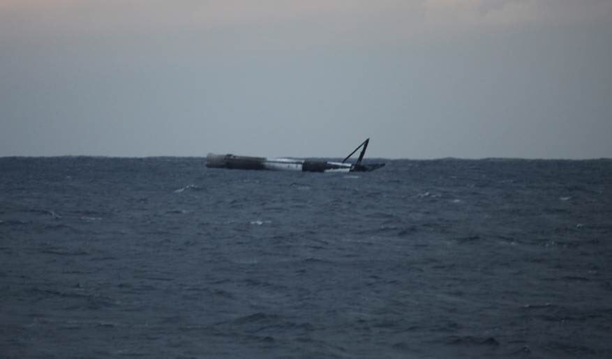
This SpaceX rocket was performing a very high retro-thrust landing in water. It wasn't expected to survive, but did. Image: SpaceX
SpaceX’s most recent rocket launch saw the Falcon 9 perform a high retro-thrust over water, with no drone ship in sight. SpaceX never intended to reuse this rocket, and they haven’t said exactly why.
This rocket was meant to test very high retrothrust landing in water so it didn’t hurt the droneship, but amazingly it has survived. We will try to tow it back to shore. pic.twitter.com/hipmgdnq16
This launch was conducted on January 31st, and the payload was a communications satellite called GovSat-1. It’s a public-private partnership, and GovSat-1 is a heavy satellite which was placed into a particularly high orbit. It will be used by the government of Luxembourg, and by a private European company called SES. It’ll provide secure communications and surveillance for the military, and it has anti-jamming features to help it resist attack.
A high orbit and a heavy payload means that the Falcon 9 that launched it might not have had enough fuel for its customary drone landing. But other Falcon 9s have launched payloads this high and landed on droneships for reuse. So what gives?
According to SpaceX, they never planned to land and reuse this one. They didn’t exactly say why they did it this way, but it’s been speculated that this one was an older iteration of the Falcon 9 known as the Block3. This is the second time SpaceX flew a Block 3 iteration without trying to reuse it. The first time they launched one without reusing it, it carried 10 Iridium satellites into low-Earth orbit.
The Falcon 9 is flying in Block 4 configuration now, with Block 5 coming in the near future. SpaceX says that the Falcon 9 Block 5 will improve the performance and the reusability of the rocket in the future. They’ve also stated that the Block 5 will be the final configuration. Maybe they let this one land in the ocean because it’s just not needed anymore.
Yes. Block 5 is the final upgrade of the Falcon architecture. Significantly improves performance & ease of reusability. Flies end of year.
SpaceX’s reusable rocketry technology is their primary development. The main booster of their Falcon 9 can be reconditioned and used again and again, keeping costs down. After lift-off, and after the primary stage is released, the main-stage booster lands on a SpaceX drone ship, where it is secured and delivered to shore to be reused.
In this case, SpaceX wanted to test a high retro-thrust landing. The test consisted of three separate burns performed over water, rather than on a drone ship, to avoid damaging the ship. The rocket itself wasn’t expected to survive, but did. Or it partly survived, anyway. As Elon Musk confirmed in his tweet:
The retro-thrust rockets on SpaceX rockets like the Falcon 9 allow the rocket to land softly. They thrust in the opposite direction the rocket is landing, and cushion the Falcon 9’s landing on the droneship.
With the successful static test of SpaceX’s Falcon Heavy last week, a first launch for the Heavy is in sight. Testing high retro-thrust landings could be related to the upcoming first launch, even though, as Elon Musk said, merely getting the Falcon Heavy off the pad and back would constitute a successful first flight. But that’s just a guess.
Falcon Heavy hold-down firing this morning was good. Generated quite a thunderhead of steam. Launching in a week or so. pic.twitter.com/npaqatbNir
The Falcon Heavy is designed to be reusable, just like its little brother, the Falcon 9. Reusability is key to SpaceX and is the whole reason Musk started the company: to make spaceflight more affordable, and to help humanity travel beyond the Moon.
SpaceX plans to tow this Falcon 9 back to shore and see if it can be salvaged. But after being dunked in salt water, any meaningful salvage seems unlikely. Who knows. Maybe Elon Musk will use it for flame-thrower target practice.
But the fate of this single rocket isn’t really that important in the grand scheme of things. What’s important is that SpaceX is still testing designs, and still pushing the boundaries of lower-cost spaceflight.
With that in mind, here’s hoping the whiz kids at SpaceX can destroy a few more rockets. After all, it’s all in the name of science.
IllustrisTNG is a new simulation model for the Universe. It used over 24,000 processors over the course of more than two months to produce the largest hydrodynamic simulation project to date for the emergence of cosmic structures. Image: IllustrisTNG
The first results of the IllustrisTNG Project have been published in three separate studies, and they’re shedding new light on how black holes shape the cosmos, and how galaxies form and grow. The IllustrisTNG Project bills itself as “The next generation of cosmological hydrodynamical simulations.” The Project is an ongoing series of massive hydrodynamic simulations of our Universe. Its goal is to understand the physical processes that drive the formation of galaxies.
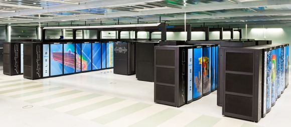
At the heart of IllustriousTNG is a state of the art numerical model of the Universe, running on one of the most powerful supercomputers in the world: the Hazel Hen machine at the High-Performance Computing Center in Stuttgart, Germany. Hazel Hen is Germany’s fastest computer, and the 19th fastest in the world.
The Hazel Hen Supercomputer is based on Intel processors and Cray network technologies. Image: IllustrisTNG
Our current cosmological model suggests that the mass-energy density of the Universe is dominated by dark matter and dark energy. Since we can’t observe either of those things, the only way to test this model is to be able to make precise predictions about the structure of the things we can see, such as stars, diffuse gas, and accreting black holes. These visible things are organized into a cosmic web of sheets, filaments, and voids. Inside these are galaxies, which are the basic units of cosmic structure. To test our ideas about galactic structure, we have to make detailed and realistic simulated galaxies, then compare them to what’s real.
Astrophysicists in the USA and Germany used IllustrisTNG to create their own universe, which could then be studied in detail. IllustrisTNG correlates very strongly with observations of the real Universe, but allows scientists to look at things that are obscured in our own Universe. This has led to some very interesting results so far, and is helping to answer some big questions in cosmology and astrophysics.
How Do Black Holes Affect Galaxies?
Ever since we’ve learned that galaxies host supermassive black holes (SMBHs) at their centers, it’s been widely believed that they have a profound influence on the evolution of galaxies, and possibly on their formation. That’s led to the obvious question: How do these SMBHs influence the galaxies that host them? Illustrious TNG set out to answer this, and the paper by Dr. Dylan Nelson at the Max Planck Institute for Astrophysics shows that “the primary driver of galaxy color transition is supermassive blackhole feedback in its low-accretion state.”
“The only physical entity capable of extinguishing the star formation in our large elliptical galaxies are the supermassive black holes at their centers.” – Dr. Dylan Nelson, Max Planck Institute for Astrophysics,
Galaxies that are still in their star-forming phase shine brightly in the blue light of their young stars. Then something changes and the star formation ends. After that, the galaxy is dominated by older, red stars, and the galaxy joins a graveyard full of “red and dead” galaxies. As Nelson explains, “The only physical entity capable of extinguishing the star formation in our large elliptical galaxies are the supermassive black holes at their centers.” But how do they do that?
Nelson and his colleagues attribute it to supermassive black hole feedback in its low-accretion state. What that means is that as a black hole feeds, it creates a wind, or shock wave, that blows star-forming gas and dust out of the galaxy. This limits the future formation of stars. The existing stars age and turn red, and few new blue stars form.
This is a rendering of gas velocity in a massive galaxy cluster in IllustrisTNG. Black areas are hardly moving, and white areas are moving at greater than 1000km/second. The black areas are calm cosmic filaments, the white areas are near super-massive black holes (SMBHs). The SMBHs are blowing away the gas and preventing star formation. Image: IllustrisTNG
How Do Galaxies Form and How Does Their Structure Develop?
It’s long been thought that large galaxies form when smaller galaxies join up. As the galaxy grows larger, its gravity draws more smaller galaxies into it. During these collisions, galaxies are torn apart. Some stars will be scattered, and will take up residence in a halo around the new, larger galaxy. This should give the newly-created galaxy a faint background glow of stellar light. But this is a prediction, and these pale glows are very hard to observe.
“Our predictions can now be systematically checked by observers.” – Dr. Annalisa Pillepich (Max Planck Institute for Astrophysics)
IllustrisTNG was able to predict more accurately what this glow should look like. This gives astronomers a better idea of what to look for when they try to observe this pale stellar glow in the real Universe. “Our predictions can now be systematically checked by observers,” Dr. Annalisa Pillepich (MPIA) points out, who led a further IllustrisTNG study. “This yields a critical test for the theoretical model of hierarchical galaxy formation.”
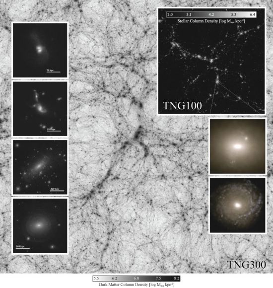
A composite image from IllustrisTNG. Panels on the left show galaxy-galaxy interactions and the fine-grained structure of extended stellar halos. Panels on the right show stellar light projections from two massive central galaxies at the present day. It’s easy to see how the light from massive central galaxies overwhelms the light from stellar halos. Image: IllustrisTNG
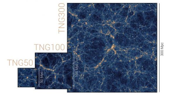
IllustrisTNG is an on-going series of simulations. So far, there have been three IllustrisTNG runs, each one creating a larger simulation than the previous one. They are TNG 50, TNG 100, and TNG 300. TNG300 is much larger than TNG50 and allows a larger area to be studied which reveals clues about large-scale structure. Though TNG50 is much smaller, it has much more precise detail. It gives us a more detailed look at the structural properties of galaxies and the detailed structure of gas around galaxies. TNG100 is somewhere in the middle.
TNG 50, TNG 100, and TNG 300. Image: IllustrisTNG
IllustrisTNG is not the first cosmological hydrodynamical simulation. Others include Eagle, Horizon-AGN, and IllustrisTNG’s predecessor, Illustris. They have shown how powerful these predictive theoretical models can be. As our computers grow more powerful and our understanding of physics and cosmology grow along with them, these types of simulations will yield greater and more detailed results.