Catastrophic Impacts Made Life on Earth Possible

According to a new study, meteors may be less dangerous than we thought, thanks to Earth's atmosphere. Credit: David A Aguilar (CfA).

How did life on Earth originally develop from random organic compounds into living, evolving cells? It may have relied on impacts by enormous meteorites and comets — the same sort of catastrophic events that helped bring an end to the dinosaurs’ reign 65 million years ago. In fact, ancient impact craters might be precisely where life was able to develop on an otherwise hostile primordial Earth.

This is the hypothesis proposed by Sankar Chaterjee, Horn Professor of Geosciences and the curator of paleontology at the Museum of Texas Tech University.

“This is bigger than finding any dinosaur. This is what we’ve all searched for – the Holy Grail of science,” Chatterjee said.

Our planet wasn’t always the life-friendly “blue marble” that we know and love today. At one point early in its history it was anything but hospitable to life as we know it.

“When the Earth formed some 4.5 billion years ago, it was a sterile planet inhospitable to living organisms,” Chatterjee said. “It was a seething cauldron of erupting volcanoes, raining meteors and hot, noxious gasses. One billion years later, it was a placid, watery planet teeming with microbial life – the ancestors to all living things.”

Exactly how did this transition happen? That’s the Big Question in paleontology, and Chatterjee believes he may have found the answer lying within some of the world’s oldest and largest impact craters.

After studying the environments of the oldest known fossil-containing rocks in Greenland, Australia and South Africa, Chatterjee said these could be remnants of ancient craters and may be the very spots where life began in deep, dark and hot environments — similar to what’s found near thermal vents in today’s oceans.

Larger meteorites that created impact basins of about 350 miles in diameter inadvertently became the perfect crucibles, according to Chatterjee. These meteorites also punched through the Earth’s crust, creating volcanically driven geothermal vents. They also brought the basic building blocks of life that could be concentrated and polymerized in the crater basins.

In addition to new organic compounds — and, in the case of comets, considerable amounts of water — impacting bodies may also have brought the necessary lipids needed to help protect RNA and allow it to develop further.

“RNA molecules are very unstable. In vent environments, they would decompose quickly. Some catalysts, such as simple proteins, were necessary for primitive RNA to replicate and metabolize,” Chatterjee said. “Meteorites brought this fatty lipid material to early Earth.”

How organic compounds in crater basins were encapsulated in lipid membranes and became the first cells (Chatterjee)

Based on research in Australia by University of California professor David Deamer, the ingredients for all-important cell membranes were delivered to Earth via meteorites and existed in water-filled craters.

“This fatty lipid material floated on top of the water surface of crater basins but moved to the bottom by convection currents,” suggests Chatterjee. “At some point in this process during the course of millions of years, this fatty membrane could have encapsulated simple RNA and proteins together like a soap bubble. The RNA and protein molecules begin interacting and communicating. Eventually RNA gave way to DNA – a much more stable compound – and with the development of the genetic code, the first cells divided.”

And the rest, as they say, is history. (Well, biology really, and no small amount of chemistry and paleontology… and some astrophysics… well you get the idea.)

Chatterjee recognizes that further experiments will be needed to help support or refute this hypothesis. He will present his findings Oct. 30 during the 125th Anniversary Annual Meeting of the Geological Society of America in Denver, Colorado.

Source: Texas Tech news article by John Davis

Watch the Sun Split Apart

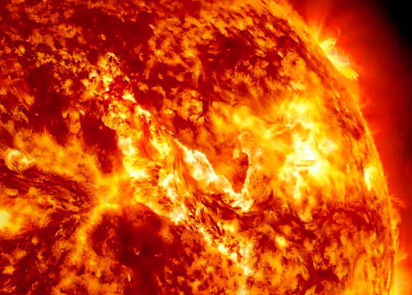
Canyon of Fire on the Sun, Credit: NASA/SDO/AIA)

Here’s your amazing oh-my-gosh-space-is-so-cool video of the day — a “canyon of fire” forming on the Sun after the liftoff and detachment of an enormous filament on September 29-30. A new video, created from images captured by the Solar Dynamics Observatory (SDO) and assembled by NASA’s Goddard Space Flight Center, shows the entire dramatic event unfolding in all its mesmerizing magnetic glory.

Watch it below:

Solarrific! (And I highly suggest full-screening it in HD.) That filament was 200,000 miles long, and the rift that formed afterwards was well over a dozen Earths wide!

Captured in various wavelengths of light by SDO’s Atmospheric Imaging Assembly (AIA) the video shows the solar schism in different layers of the Sun’s corona, which varies greatly in temperature at different altitudes.

According to the description from Karen Fox at GSFC:

“The red images shown in the movie help highlight plasma at temperatures of 90,000° F and are good for observing filaments as they form and erupt. The yellow images, showing temperatures at 1,000,000° F, are useful for observing material coursing along the sun’s magnetic field lines, seen in the movie as an arcade of loops across the area of the eruption. The browner images at the beginning of the movie show material at temperatures of 1,800,000° F, and it is here where the canyon of fire imagery is most obvious.”

Now, there’s not really any “fire” on the Sun — that’s just an illustrative term. What we’re actually seeing here is plasma contained by powerful magnetic fields that constantly twist and churn across the Sun’s surface and well up from its interior. The Sun is boiling with magnetic fields, and when particularly large ones erupt from deep below its surface we get the features we see as sunspots, filaments, and prominences.

When those fields break, the plasma they contained gets blasted out into space as coronal mass ejections… and this is what typically happens when one hits Earth. (But it could be much worse.)

Hey, that’s what it’s like living with a star!

Stay up to date on the latest solar events on the SDO mission page here.

Titan’s North Pole is Loaded With Lakes

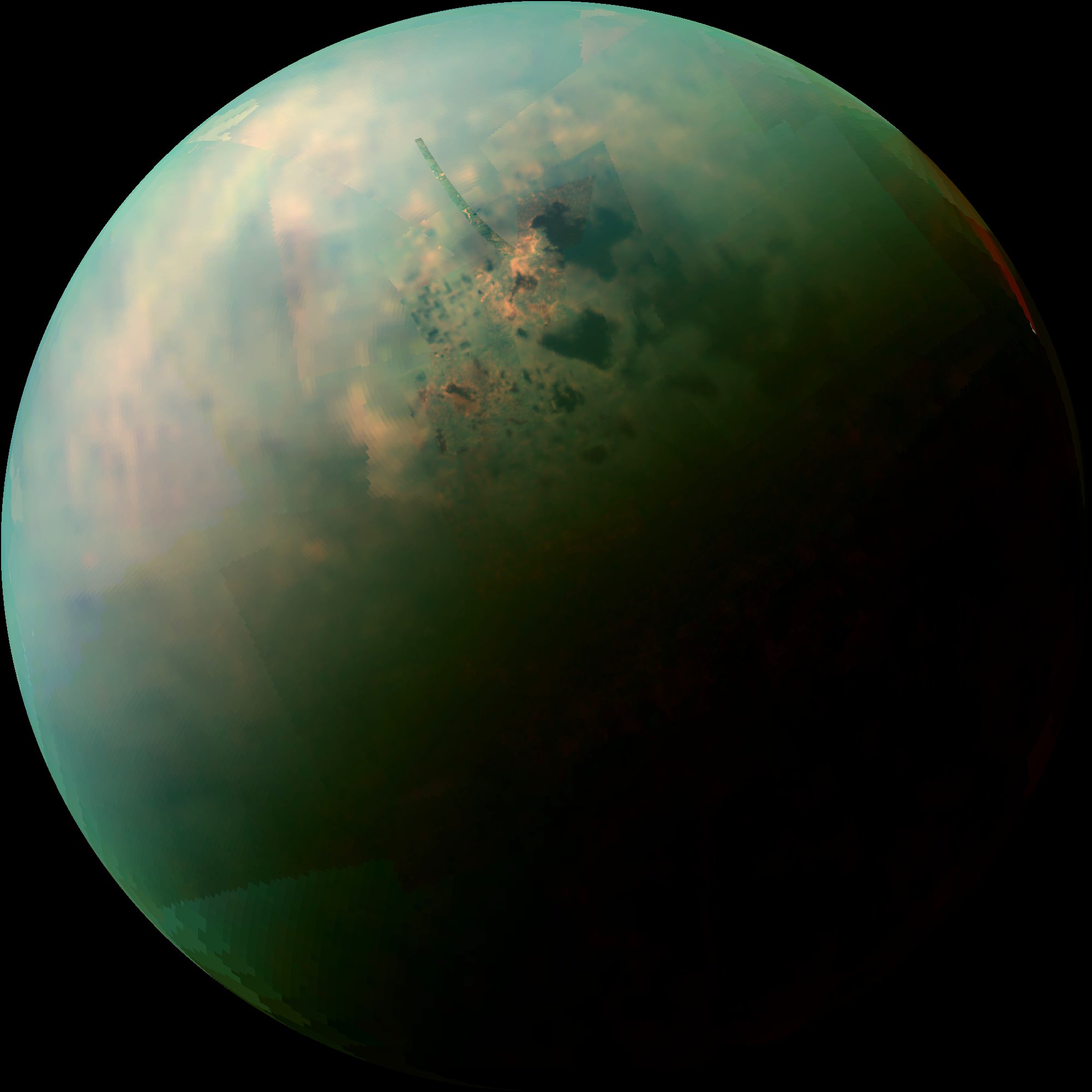
Titan's north pole is home to many methane lakes. Credit: NASA

A combination of exceptionally clear weather, the steady approach of northern summer, and a poleward orbital path has given Cassini — and Cassini scientists — unprecedented views of countless lakes scattered across Titan’s north polar region. In the near-infrared mosaic above they can be seen as dark splotches and speckles scattered around the moon’s north pole. Previously observed mainly via radar, these are the best visual and infrared wavelength images ever obtained of Titan’s northern “land o’ lakes!”


Titan is currently the only other world besides Earth known to have stable bodies of liquid on its surface, but unlike Earth, Titan’s lakes aren’t filled with water — instead they’re full of liquid methane and ethane, organic compounds which are gases on Earth but liquids in Titan’s incredibly chilly -290º F (-180º C) environment.

While one large lake and a few smaller ones have been previously identified at Titan’s south pole, curiously almost all of Titan’s lakes appear near the moon’s north pole.

Infrared observations of Titan's northern lakes (NASA/JPL-Caltech/SSI)
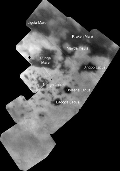
Infrared observations of Titan’s northern lakes. The cross marks Titan’s geographic north pole. (NASA/JPL-Caltech/SSI)

For an idea of scale, the large lake at the upper right above (and the largest lake on Titan) Kraken Mare is comparative in size to the Caspian Sea and Lake Superior combined. Kraken Mare is so large that sunlight was seen reflecting off its surface in 2009. Punga Mare, nearest Titan’s pole, is 240 miles (386 km) across.

Besides revealing the (uncannily) smooth surfaces of lakes — which appear dark in near-infrared wavelengths but would also be darker than the surrounding landscape in visible light —  these Cassini images also show an unusually bright terrain surrounding them. Since the majority of Titan’s lakes are found within this bright region it’s thought that there could be a geologic correlation; is this Titan’s version of karst terrain, like what’s found in the southeastern U.S. and New Mexico? Could these lakes be merely the visible surfaces of a vast underground hydrocarbon aquifer? Or are they shallow pools filling depressions in an ancient lava flow?

Annotated infrared mosaic of Titan's north pole (NASA/JPL-Caltech/SSI)
Annotated infrared mosaic of Titan’s north pole (NASA/JPL-Caltech/SSI)

Or, are they the remains of once-larger lakes and seas which have since evaporated? The orange-hued regions in the false-color mosaic may be evaporite — the Titan equivalent of salt flats on Earth. The evaporated material is thought to be organic chemicals originally from Titan’s haze particles that were once dissolved in liquid methane.

“Is this an indication that with increased warmth, the seas and lakes are starting to evaporate, leaving behind a deposit of organic material,” wrote Carolyn Porco, Cassini Imaging Team Leader, in an email earlier today. “…in other words, the Titan equivalent of a salt-flat?”

The largest lake at Titan’s south pole, Ontario Lacus, has been previously compared to such an ephemeral lake in Namibia called the Etosha Pan. (Read more here.)

These observations are only possible because of the extended and long-term study of Saturn and its family of moons by the Cassini spacecraft, which began with its establishing orbit in 2004 and has since continued across multiple seasons over a third of the ringed planet’s year. The existence of methane lakes on Titan is undoubtedly fascinating, but how deep the lakes are, where they came from and how they behave in Titan’s environment have yet to be discovered. Luckily, the changing season is on our side.

“Titan’s northern lakes region is one of the most Earth-like and intriguing in the solar system,” said Linda Spilker, Cassini project scientist, based at NASA’s Jet Propulsion Laboratory, Pasadena, Calif. “We know lakes here change with the seasons, and Cassini’s long mission at Saturn gives us the opportunity to watch the seasons change at Titan, too. Now that the sun is shining in the north and we have these wonderful views, we can begin to compare the different data sets and tease out what Titan’s lakes are doing near the north pole.”

The images shown above were obtained by Cassini’s visual and infrared mapping spectrometer (VIMS) during a close flyby of Titan on Sept. 12, 2013.

Read more on the Cassini Imaging Central Laboratory for Operations (CICLOPS) site here and on the NASA site here.

“But how thrilling it is to still be uncovering new territory on this fascinating moon… a place that, until Cassini’s arrival at Saturn nearly 10 years ago, was the largest single expanse of unseen terrain we had remaining in our solar system. Our adventures here have been the very essence of exploration. And it’s not over yet!”

– Carolyn Porco on Facebook

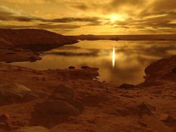
An illustration of a Titanic lake by Ron Miller. All rights reserved. Used with permission.
An illustration of a Titanic lake © Ron Miller. All rights reserved.

Also, check out a corresponding article and intriguing illustration of robotic Titan exploration by space artist extraordinaire Ron Miller on io9.com.

There Are Now Officially Over 1,000 Confirmed Exoplanets!

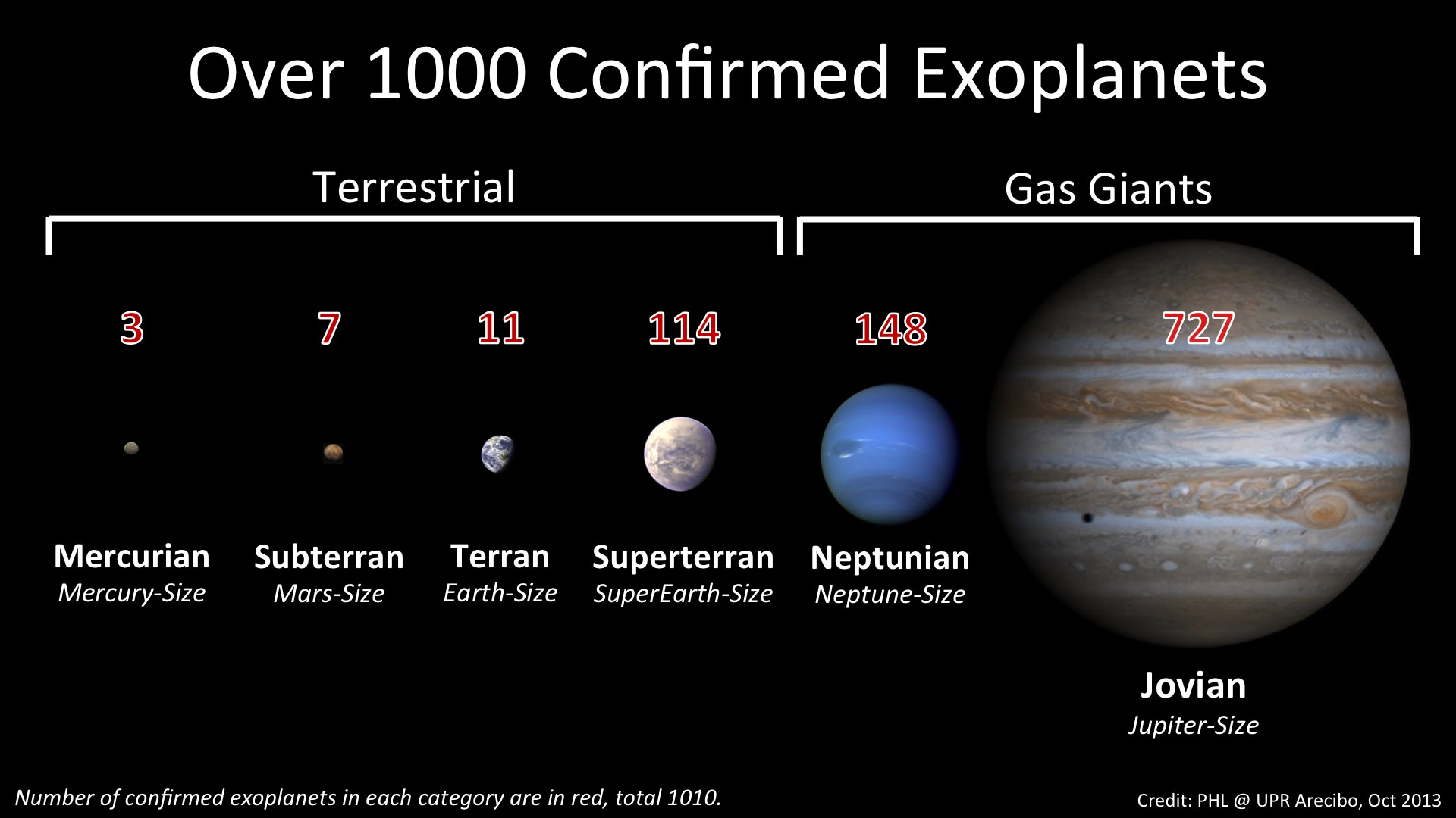
More than 1,000 exoplanets have been confirmed and cataloged (PHL @ UPR Arecibo)

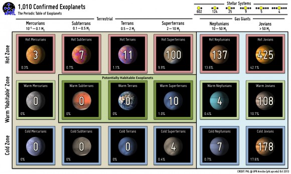
It was just last week that we reported on the oh-so-close approach to 1,000 confirmed exoplanets discovered thus far, and now it’s official: the Extrasolar Planets Encyclopedia now includes more than 1,000! (1,010, to be exact.)

21 years after the first planets beyond our own Solar System were even confirmed to exist, it’s quite a milestone!

The milestone of 1,000 confirmed exoplanets was surpassed on October 22, 2013 after twenty-one years of discoveries. The long-established and well-known Extrasolar Planets Encyclopedia now lists 1,010 confirmed exoplanets.

Not all current exoplanet catalogs list the same numbers as this depends on their particular criteria. For example, the more recent NASA Exoplanet Archive lists just 919. Nevertheless, over 3,500 exoplanet candidates are waiting for confirmation.

The first confirmed exoplanets were discovered by the Arecibo Observatory in 1992. Two small planets were found around the remnants of a supernova explosion known as a pulsar. They were the surviving cores of former planets or newly formed bodies from the ashes of a dead star. This was followed by the discovery of exoplanets around sun-like stars in 1995 and the beginning of a new era of exoplanet hunting.

A "Periodic Table of Exoplanets" as listed by the Extrasolar Planets Encyclopedia (PHL)
A “Periodic Table of Exoplanets” as listed by the Extrasolar Planets Encyclopedia (PHL)

(The first exoplanets to be confirmed were two orbiting pulsar PSR B1257+12, 1,000 light-years away. A third was found in 2007.)

Exoplanet discoveries have been full of surprises from the outset. Nobody expected exoplanets around the remnants of a dead star (i.e. PSR 1257+12), nor Jupiter-size orbiting close to their stars (i.e. 51 Pegasi). We also know today of stellar systems packed with exoplanets (i.e. Kepler-11), around binary stars (i.e. Kepler-16), and with many potentially habitable exoplanets (i.e. Gliese 667C).

Read more: Earthlike Exoplanets are All Around Us

“The discovery of many worlds around others stars is a great achievement of science and technology. The work of scientists and engineers from many countries were necessary to achieve this difficult milestone. However, one thousand exoplanets in two decades is still a small fraction of those expected from the billions of stars in our galaxy. The next big goal is to better understand their properties, while detecting many new ones.”

– Prof. Abel Mendéz, Associate Professor of Physics and Astrobiology, UPR Arecibo

Source: Press release by Professor Abel Méndez at the Planetary Habitability Laboratory (PHL) at Arecibo

Read more: Kepler Can Still Hunt For Earth-Sized Exoplanets

While not illustrating the full 1,010 lineup, this is still a mesmerizing visualization by Daniel Fabrycky of 885 planetary candidates in 361 systems as found by the Kepler mission. (I for one am looking forward to the third installment!)

Of course, scientists are still hunting for the “Holy Grail” of extrasolar planets: an Earth-sized, rocky world orbiting a Sun-like star within its habitable zone. But with new discoveries and confirmations happening almost every week, it’s now only a matter of time. Read more in this recent article by Universe Today writer David Dickinson.

This is the Moon, the Whole Moon and Nothing But the Moon

Synthetic view of the waxing Moon as viewed from Earth on 2013-10-15 17:00:00 UTC [NASA/GSFC/Arizona State University].

Take a look around the Moon… no, really, take a good look AROUND the Moon! This is a fantastic animation of our planetary partner in space made by the folks on the Lunar Reconnaissance Orbiter team at Arizona State University. Assembled from reflectance maps and digital terrain models created from data gathered by LRO’s wide-angle camera, this full 360-degree portrait of the Moon shows its surface as if it were receiving direct top-down sunlight on all points — a physical impossibility, yes, but it gives us a great view of pretty much everything (including the far side, which for obvious reasons most of us never get a good look at.)

In addition to shining a light on the lunar landscape (pun intended) the vast amounts of data used to create the view above can also be used to calculate the type of illumination that would be found on any point on the Moon, at any time, allowing for better targeted observation planning with LRO’s narrow-angle camera.

Read more about how this process was engineered here, and see a more recent result of these new capabilities below:

While the image above wouldn’t have been visible from anywhere on North America on October 15, 2013 at 2 p.m. EDT, it’s what would have been seen in the night sky above Mumbai — but no international calls to India were needed, as the view could simply be generated from the LRO WAC data and a ray-tracing algorithm that plots the angles of light and shadow across the lunar terrain. Voilà — it’s Insta-Moon*!

*Some assembly required.

Read more on the Arizona State University LROC site here (and to really blow your mind, watch the high-resolution version here.)

Want to explore the Moon on your Android or iPhone? Check out our Phases of the Moon app!

These Antarctic Research Photos Look Like Exploration on Another Planet

Researchers work in the Antarctic polar night during a storm (Credit: Stefan Hendricks, Alfred Wegner Institute)

Some day, human explorers will land a spacecraft on the surface of Europa, Enceladus, Titan, or some other icy world and investigate first-hand the secrets hidden beneath its frozen surface. When that day comes — and it can’t come too soon for me! — it may look a lot like this.

One of a series of amazing photos by Stefan Hendricks taken during the Antarctic Winter Ecosystem & Climate Study (AWECS), a study of Antarctica’s sea ice conducted by the Alfred Wegener Institute in Germany, the image above shows researchers working on the Antarctic ice during a winter snowstorm. It’s easy to imagine them on the night-side surface of Europa, with the research vessel Polarstern standing in for a distant illuminated lander (albeit rather oversized).

Hey, one can dream!

One of the goals of the campaign, called CryoVex, was to look at how ESA’s CryoSat mission can be used to understand the thickness of sea ice in Antarctica. The extent of the Antarctic sea ice in winter is currently more than normal, which could be linked to changing atmospheric patterns.

Antarctica’s massive shelves of sea ice in winter are quite dramatic landscapes, and remind us that there are very alien places right here on our own planet.

See this and more photos from the mission on the ESA website (really, go check them out!)

Awesome Photo: Aurora, Airglow, City Lights and Shining Stars

Photo taken by ESA astronaut Luca Parmitano on Sept. 5, 2013 (ESA/NASA)

Italian astronaut Luca Parmitano shares a lot of fantastic photos taken from his privileged position 260 miles up aboard the Space Station, orbiting the planet 16 times a day. This is his latest, a stunning view of nighttime city lights spread out beneath a glowing dome of ghostly airglow and shimmering aurorae, with a backdrop of brightly shining stars. The dark silhouette of a solar array is in the foreground at right.

And in case you were wondering, yes, astronauts certainly can see stars while in space. A lot of them, in fact. (Except up there, they don’t twinkle… but they’re no less beautiful!)

“Every time we look into the sky and we admire the same stars, we share the same experience with all those who still know how to dream.”

– Luca Parmitano

Luca Parmitano is the first of ESA’s new generation of astronauts to fly into space. The current mission, Volare, is ESA’s fifth long-duration Space Station mission. During his six-month-long stay aboard the ISS, Luca has been conducting research for ESA and international partners as well as taken many photographs of our planet, sharing them on Twitter, Flickr, and the Volare mission blog.

See this and more photos taken by Luca on the Volare Flickr page here.

Image credit: ESA/NASA

This is Comet ISON Seen From Mars

HiRISE image of comet ISON from Mars orbit (NASA/JPL/University of Arizona)

It’s not much to look at, but there it is: the incoming comet ISON (aka C/2012 S1) as seen by the HiRISE camera aboard NASA’s Mars Reconnaissance Orbiter. An enlarged version of one of four just-released images, this represents a 256-by-256-pixel patch of sky imaged by HiRISE on Sunday, September 29. ISON is the fuzzy blob at center, 8.5 million miles (13.8 million km) away.

See all four images below:

HiRISE images of ISON on Sept. 29, 2013 (NASA/JPL/University of Arizona)

HiRISE researchers Alan Delamere and Alfred McEwen explained in a news release:

Based on preliminary analysis of the data, the comet appears to be at the low end of the range of brightness predictions for the observation. As a result, the image isn’t visually pleasing but low coma activity is best for constraining the size of the nucleus. This image has a scale of approximately 8 miles (13.3 km) per pixel, larger than the comet, but the size of the nucleus can be estimated based on the typical brightness of other comet nuclei. The comet, like Mars, is currently 241 million kilometers from the Sun. As the comet gets closer to the sun, its brightness will increase to Earth-based observers and the comet may also become intrinsically brighter as the stronger sunlight volatilizes the comet’s ices.

More images of ISON from HiRISE are expected as the comet came even closer to Mars, approaching within 6.7 million miles (10.8 million km), but the illumination from those angles may not be as good.

NOTE: These are preliminary single (non-stacked) images, and still contain noise and background stars – hence the fuzziness. Plus HiRISE was not really designed for sky imaging! (Thanks to HiRISE team member Kristin Block for the info.)

So even though it’s at the “low end” of brightness predictions in these HiRISE images, ISON certainly hasn’t “fizzled” like some reports claimed earlier this year (although just how bright it will get in our skies remains to be seen.)

Comet ISON will make its closest pass of the Sun (perihelion) on November 28, 2013, coming within 724,000 miles (1.16 million km) before heading back out into the Solar System… if it survives the encounter, that is. Read more about how to view ISON here and here.

Source: University of Arizona HiRISE article by Alan Delamere and Alfred McEwen

_______________

Worried about ISON’s first (and possibly last) visit to the inner Solar System? Don’t be. Recent rumors of comet-caused catastrophe are greatly exaggerated… read more on David Dickinson’s article Debunking Comet ISON Conspiracy Theories (No, ISON is Not Nibiru).

Navigating the Cosmos by Quasar

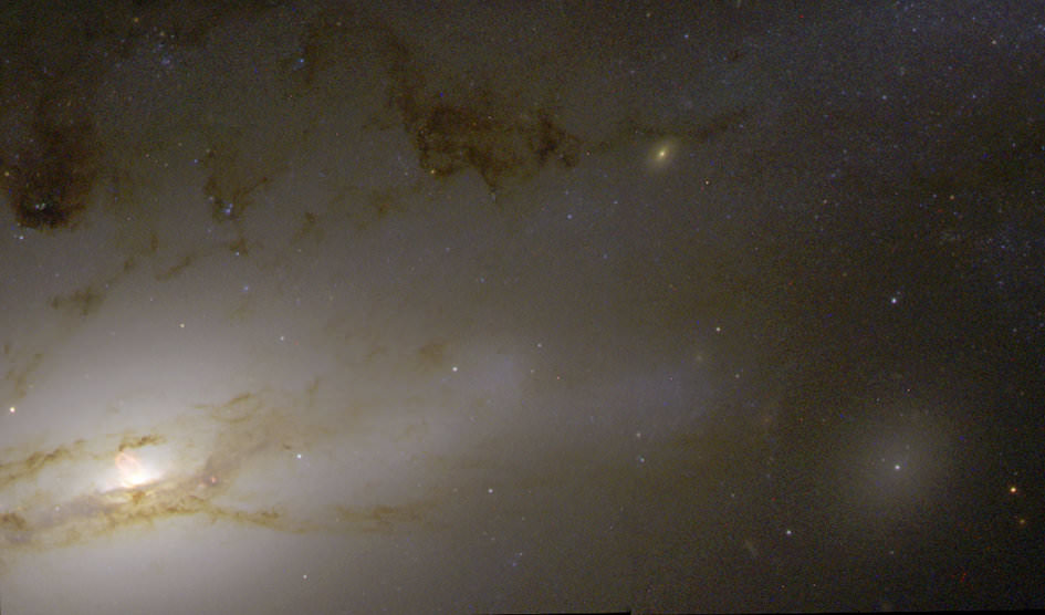
A quasar resides in the hub of the nearby galaxy NGC 4438. Credit: NASA/ESA, Jeffrey Kenney (Yale University), Elizabeth Yale (Yale University)

50 million light-years away a quasar resides in the hub of galaxy NGC 4438, an incredibly bright source of light and radiation that’s the result of a supermassive black hole actively feeding on nearby gas and dust (and pretty much anything else that ventures too closely.) Shining with the energy of 1,000 Milky Ways, this quasar — and others like it — are the brightest objects in the visible Universe… so bright, in fact, that they are used as beacons for interplanetary navigation by various exploration spacecraft.

“I must go down to the seas again, to the lonely sea and the sky,
And all I ask is a tall ship and a star to steer her by.”
– John Masefield, “Sea Fever”

Deep-space missions require precise navigation, especially when approaching bodies such as Mars, Venus, or comets. It’s often necessary to pinpoint a spacecraft traveling 100 million km from Earth to within just 1 km. To achieve this level of accuracy, experts use quasars – the most luminous objects known in the Universe – as beacons in a technique known as Delta-Differential One-Way Ranging, or delta-DOR.

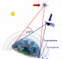
How delta-DOR works (ESA)

Delta-DOR uses two antennas in distant locations on Earth (such as Goldstone in California and Canberra in Australia) to simultaneously track a transmitting spacecraft in order to measure the time difference (delay) between signals arriving at the two stations.

Unfortunately the delay can be affected by several sources of error, such as the radio waves traveling through the troposphere, ionosphere, and solar plasma, as well as clock instabilities at the ground stations.

Delta-DOR corrects these errors by tracking a quasar that is located near the spacecraft for calibration — usually within ten degrees. The chosen quasar’s direction is already known extremely well through astronomical measurements, typically to closer than 50 billionths of a degree (one nanoradian, or 0.208533 milliarcsecond). The delay time of the quasar is subtracted from that of the spacecraft’s, providing the delta-DOR measurement and allowing for amazingly high-precision navigation across long distances.

“Quasar locations define a reference system. They enable engineers to improve the precision of the measurements taken by ground stations and improve the accuracy of the direction to the spacecraft to an order of a millionth of a degree.”

– Frank Budnik, ESA flight dynamics expert

So even though the quasar in NGC 4438 is located 50 million light-years from Earth, it can help engineers position a spacecraft located 100 million kilometers away to an accuracy of several hundred meters. Now that’s a star to steer her by!

Read more about Delta-DOR here and here.

Source: ESA Operations

Pakistan’s “Earthquake Island” Seen From Space

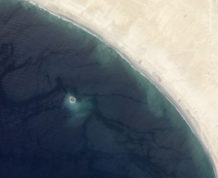
Mud island off the coast of Gwadar imaged by NASA's EO-1 satellite on Sept. 26, 2013

On the afternoon of Tuesday September 24, 2013, a 7.7-magnitude earthquake struck Balochistan province in southern Pakistan, causing widespread destruction across several districts during more than 2 minutes of powerful tremors and shaking. Sadly at least 400 people were killed (some reports say 600) and over 100,000 have been left homeless. But a weirder — if much less tragic — effect of the quake that was soon reported worldwide was the sudden appearance of a new island off the coast, a mound of mud and bubbling methane seeps rising nearly 20 meters (70 feet) from the ocean surface.

The image above, taken by NASA’s Earth Observing-1 satellite, shows the newly-formed mud island a kilometer (0.6 miles) off the Gwadar coast.

According to an article by the Pakistani news site Dawn.com, the 250-by-100-foot-long pile of mud and rocks is leaking flammable gases.

“Our team found bubbles rising from the surface of the island which caught fire when a match was lit and we forbade our team to start any flame,” said Mohammad Danish, a marine biologist from Pakistan’s National Institute of Oceanography. “It is methane gas.”

Aerial photo of the Gwadar mud volcano (National Institute of Oceanography, Pakistan)

Pakistan’s many earthquakes are the result of collisions between the Indian, Arabian, and Eurasian tectonic plates. These sorts of mud volcanoes are not particularly unusual after large quakes there… it just so happened that this one occurred near a populated coast and in relatively shallow water. (Source)

(In fact two days later another mud island was spotted off the coast of the nearby coastal town of Ormara.)

The mud volcano, which is being called “Zalzala Jazeera” (earthquake island) is not expected to last long. Wave action will eventually sweep the sediment away over the course of several months. (Dawn.com.)

Unfortunately earthquake relief efforts in the remote Taliban-dominated region are being hampered by militant activity.

Image source: NASA Earth Observatory