Will Curiosity Look for Life on Mars? Not Exactly…

“Curiosity is not a life detection mission. We’re not actually looking for life and we don’t have the ability to detect life if it was there. What we are looking for is the ingredients of life.”
– John Grotzinger, MSL Project Scientist

And with these words this latest video from NASA’s Jet Propulsion Laboratory begins, explaining what Curiosity’s goal will be once it arrives on Mars on August 5. There will be a lot of media coverage of the event and many news stories as the date approaches, and some of these will undoubtedly refer to Mars Science Laboratory as a “search for life on Mars” mission… but in reality the focus of MSL is a bit subtler than that (if no less exciting.)

But hey, one can always dream

Video: NASA/JPL

Greenland Glacier Calves Another Huge Ice Island

Petermann glacier, a 70 km (43 mile) long tongue of ice that flows into the Arctic Ocean in northwest Greenland, recently calved an “ice island” approximately 130 square kilometers (50 sq. miles) — about twice the area of Manhattan. The image above, acquired by NASA’s Terra satellite, shows the ice island as it drifts toward the ocean five days after breaking off the main glacier.

Petermann glacier has been known for birthing massive ice islands; previously in August 2010 an even larger island broke away from the glacier, measuring 251 square kilometers (97 sq. miles). That slab of ice eventually drifted into the northern Atlantic and was even visible from the Space Station a year later!

Read: Manhattan-Sized Ice Island Seen From Space

Although some of Greenland’s glaciers have been observed to be quickening their seaward pace as a result of global warming, this particular calving event — which occurred along a crack that appeared in 2001 satellite imagery — isn’t thought to be a direct result of climate but rather of ocean currents and isn’t expected to have any significant effect on the rate of Greenland’s ice loss as a whole. Still, satellite observation of such events provides valuable data for researchers monitoring the processes that are involved with rapidly accelerating Arctic ice loss.

And if you want an idea of what a slab of ice this large looks like up close, here’s a video taken by researchers on approach to a smaller chunk of the 2011 island:

NASA Earth Observatory image by Jesse Allen, using data from NASA/GSFC/METI/ERSDAC/JAROS, and U.S./Japan ASTER Science Team. (NASA/Terra)

Sally Ride, First American Woman in Space, Passes Away

Dr. Sally Ride, the first American woman to fly in space, died today, July 23, 2012. She was 61 years old.


Dr. Ride flew in space twice, first in 1983 aboard the Space Shuttle Challenger, then again aboard Challenger in 1984. She was the President and CEO of Sally Ride Science, a science education company that creates programs and products for students and teachers in elementary and middle school with a focus on encouraging girls. Dr. Ride was also a Professor of Physics (Emerita) at the University of California, San Diego. She received her B.S in Physics, B.A in English, and M.S. and PhD in Physics from Stanford University.

Sally died peacefully July 23 after a courageous 17-month battle with pancreatic cancer. She lived her life to the fullest, with boundless energy, curiosity, intelligence, passion, commitment, and love. Her integrity was absolute; her spirit was immeasurable; her approach to life was fearless.

“Sally Ride broke barriers with grace and professionalism – and literally changed the face of America’s space program. The nation has lost one of its finest leaders, teachers and explorers. Our thoughts and prayers are with Sally’s family and the many she inspired. She will be missed, but her star will always shine brightly.”

– Charles Bolden, NASA Administrator

For more information visit http://www.sallyridescience.com/.

“I didn’t really think about it that much at the time . . . but I came to appreciate what an honor it was to be selected to be the first to get a chance to go into space.” 

– Dr. Sally Ride, former NASA astronaut

(NASA/JPL video from July 2008)

Photo and video: NASA

Flashback: 1978 NASA Film Shows Viking Discoveries

In what’s a sort of foreshadowing of the upcoming August 5 MSL landing, which is being called “seven minutes of terror”, here’s a flashback film from 1978 called “19 Minutes to Earth” which looks at the discoveries made by the Viking orbiter and lander, which made its historic arrival on Mars 36 years ago, on July 20, 1976.

In true late ’70s style the video is full of funky music and (what was then) state-of-the-art video graphics. Awesome.


Even more than the music, though, what’s interesting about the 1978 film is how the subject of microbial life is discussed. Both Viking 1 and 2 were designed to search for evidence of biological activity on Mars, which they did by digging into the Martian soil and looking for signs of resulting respiration.

Although the results were initially deemed inconclusive, further research into the Viking data has prompted some scientists to claim that the landers did, in fact, find evidence of life on Mars.

It’s still a much-debated topic, one that scientists hope to help settle with the upcoming research performed by Curiosity and the Mars Science Laboratory mission.

Funky music and all, the Viking programs paved the way for all future missions to Mars. Lessons learned from Viking technology have blazed the trail for Mars research, from Pathfinder’s Sojourner rover to Spirit and Opportunity, the Mars Reconnaissance Orbiter and ESA’s Mars Express. Very soon Curiosity will continue on with the legacy of robotic exploration of the Red Planet, and someday I’m sure our children and grandchildren will look back at the “funky videos” of our time.

Let’s hope that by then they’ve made their own great strides in space exploration and have found answers to the questions that inspire us today.

Video: NASA. Image: artist’s concept of the Viking lander (NASA).

The Top 5 “Earth as Art” Images, Thanks to Landsat

NASA’s first Earth-observing Landsat satellite launched from Vandenberg Air Force Base on July 23, 1972, and to celebrate the 40th anniversary of the program they asked the public to vote on their favorite images of the planet from the Landsat Earth as Art gallery. After over 14,000 votes, these were chosen as the top 5 favorites. Happy 40th anniversary, Landsat!

Landsat images from space are not merely pictures. They contain many layers of data collected at different points along the visible and invisible light spectrum. A single Landsat scene taken from 400 miles above Earth can accurately detail the condition of hundreds of thousands of acres of grassland, agricultural crops or forests.

“Landsat has given us a critical perspective on our planet over the long term and will continue to help us understand the big picture of Earth and its changes from space,” said NASA Administrator Charles Bolden. “With this view we are better prepared to take action on the ground and be better stewards of our home.”

In cooperation with the U.S. Geological Survey (USGS), a science agency of the Interior Department, NASA launched six of the seven Landsat satellites. The resulting archive of Earth observations forms a comprehensive record of human and natural land changes.

“The first 40 years of the Landsat program have delivered the most consistent and reliable record of Earth’s changing landscape.”

– Michael Freilich, director of NASA’s Earth Science Division

“Over four decades, data from the Landsat series of satellites have become a vital reference worldwide for advancing our understanding of the science of the land,” said Interior Department Secretary Ken Salazar. “The 40-year Landsat archive forms an indelible and objective register of America’s natural heritage and thus it has become part of this department’s legacy to the American people.”

The next satellite in the series, the Landsat Data Continuity Mission (LDCM) is scheduled to launch on February 11, 2013.

(Source: NASA/GSFC)

Find out more about the ongoing Landsat mission here, and see recent visualizations from Landsat on the USGS site here.

Video: NASA/GSFC. Inset image: Industrial growth in Binhai New Area, China.  Sub-feature: Erg Iguidi, an area of ever-shifting sand dunes extending from Algeria into Mauritania in northwestern Africa, one of the chosen top 5 Earth as Art images. NASA/GSFC/USGS.

HI-C Returns Most Detailed Images Ever of the Sun’s Corona

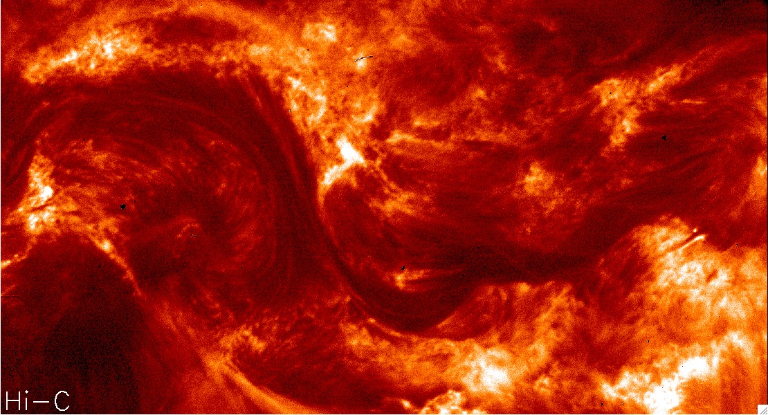
NASA’s High Resolution Coronal Imager (Hi-C) mission, launched Wednesday, July 11 from White Sands Missile Range in New Mexico, successfully returned (as promised!) the highest-resolution images of the Sun’s corona ever acquired. These images of the dynamic million-degree region of the Sun’s atmosphere will provide scientists with more information on the complex activity found near the Sun’s surface and how it affects space weather throughout the Solar System.

Launched aboard a 58-foot-tall (17 meter) Black Brant sounding rocket, Hi-C was equipped with exceptionally well-made mirrors — some of the finest ever made, according to the mission report. These mirrors allowed Hi-C to image a section of the Sun’s corona in extreme ultraviolet light with a resolution of 0.1 arcsec/pixel, distinguishing features as small as 135 miles (217 km) across. That’s five times the resolution of SDO images, or any previous space telescope for that matter.

That’s like the difference between watching a program on a tube television and an HD flatscreen monitor.

The image below shows the same region as seen by SDO’s AIA array and Hi-C’s innovative mirror-and-“light-maze” system:

Read: NASA to Launch the Finest Mirrors Ever Made

“These revolutionary images of the sun demonstrate the key aspects of NASA’s sounding rocket program, namely the training of the next generation of principal investigators, the development of new space technologies, and scientific advancements,” said Barbara Giles, director for NASA’s Heliophysics Division at NASA Headquarters in Washington.

During its 620-second suborbital flight, Hi-C took 165 images of a section of the Sun’s corona 135,000 miles (271,000 km) across, capturing wavelengths of light at 193 Angstroms emitted by the Sun’s super-hot 1.5 million kelvin corona. The images were focused on a large sunspot region, whose position was accurately predicted 27 days prior to launch.

“We have an exceptional instrument and launched at the right time,” said Jonathan Cirtain, senior heliophysicist at NASA’s Marshall Space Flight Center in Huntsville. “Because of the intense solar activity we’re seeing right now, we were able to clearly focus on a sizeable, active sunspot and achieve our imaging goals.”

Even though Hi-C’s flight only lasted ten minutes, of which 330 seconds were used for acquiring images, the amount of data gathered will be used by researchers for months.

“Even though this mission was only a few minutes long, it marks a big breakthrough in coronal studies,” said Leon Golub, lead investigator from the Harvard-Smithsonian Center for Astrophysics. “The Hi-C flight might be the most productive five minutes I’ve ever spent.”

Watch a 10-second video of the region shown above, seen from both Hi-C and SDO:

Read more about the Hi-C mission results here.

Image credits: NASA

An Orbital Adagio: Nighttime Views from the ISS

People keep making these videos from ISS photography, and we keep loving them. Here’s the latest, assembled by photographer Knate Myers to a track by John Murphy (from the movie soundtrack for Sunshine) it’s a beautiful tour of nighttime passes of the Space Station over our planet. Stars, city lights, airglow, aurorae… it’s nothing you haven’t seen before, but everything worth seeing again. Watch it.

Video: Knate Myers. All images courtesy of the Image Science & Analysis Laboratory, NASA Johnson Space Center. Via the Gateway to Astronaut Photography of Earth.

Brazilian Band Soars to New Heights with a NASA-Inspired Video


Popular Brazilian rock band Fresno recently released a new video for their new song, “Infinito”, and it really rises above the rest — literally!

It’s a story of four guys who take their childhood dream of launching a package up into space and, after years apart, come back together to make it a reality. Along the way we get to see some great views from a camera that the band members actually sent up to the edge of space via weather balloon — an accomplishment that came with its fair share of challenges.

Fresno lead member Lucas Silveira shared some behind-the-scenes info with Universe Today. “We wasted two cameras. One of them landed on a military base — exactly in the middle of a mine field — and the other simply disappeared… completely lost due to the lack of cellular signal on the landing spot.”

And even on a successful third try there were some technical difficulties.

“In our third attempt we used a different balloon, with more capacity, and it managed to fly for over 3.5 hours… but our camera only survived for around 2.5 hours. So we had to send a smaller balloon just to capture the ‘popping up’ moment, and added it to the ‘main balloon ride’ on post production.”

Still, the results — a dizzying view of Earth from 35 km up — are well worth it, and the story is an inspiring one… inspired, in fact, by NASA.

“I wrote this song after watching a video by NASA in which they zoom out from the Himalayas to the edge of the universe, showing the areas that still yet to be mapped. We are so infinitely small in the middle of all this greatness, and suddenly our problems get as tiny in our heads as our lucky existence here. It’s about searching for better days, creating a better future through proactivity and not letting others letting you down.”

When you soar that high it’s hard to feel let down.

Video courtesy of Fresno. Technical and launch assistance provided by ACRUX Aerospace Technologies. Band photo by Gustavo Vara.

Independent Filmmaker Wants to Kickstart America’s Space Program

“If Kennedy said ‘we will go to the Moon…some time before the century ends,’ what is… what is that? That’s not ambition. That’s pandering.”
– Neil deGrasse Tyson, Fight for Space

Here we are on the 43rd anniversary of the Apollo Moon landing, with no more shuttles flying, slashed space program budgets and no real targeted plan to get people off this world and onto another. American students score abysmally in science and math, and the general public thinks NASA is dead. What’s happened to America’s drive? What’s happened to the nation’s sense of wonder, its devotion to science, engineering, education and its man-on-the-Moon motivation?

Film producer Paul Hildebrandt wants to find out. But he needs your help.

Hildebrandt and his team from Eventide Visuals in Chico, CA, are creating an independent feature-length documentary about America’s space program, called “Fight for Space”. It’s not a collection of launch videos and CGI solar system shots, though; Hildebrandt is digging deeper into what originally made the U.S. space program great — and what has happened to it since then.

“We are producing a documentary that will examine the reasons why our space program is not all it can be. We are also going to show that space IS worth the time, money, and energy that it needs, not for only exploration and scientific reasons but for economic, planetary security, and cultural reasons as well,” writes Hildebrandt.

Hildebrandt has been attending space symposiums and traveling to interview key figures in science and space outreach, like Neil deGrasse Tyson, Bill Nye, Robert Zubrin and Congressman Dana Rohrabacher. He’s talked with scientists, astronauts, educators and regular everyday Americans about the importance of the space program. But in order for the Fight to continue, he needs our help.

Fortunately, that’s what Kickstarter is here for. Fight for Space is looking to get a little backing from interested and like-minded space fans to keep the process moving, and hopefully see the film become a fully produced, publicized, and possibly broadcasted reality.

“With your help we can bring awareness to this issue and come closer to making our space program a priority for this country once again.”

You can pledge any amount, from $10 to $10,000 or more (and see the incremental rewards of doing so) on the Fight for Space Kickstarter page here, and visit the Fight for Space website here.

“Please, support our film by donating above and share this project with your friends, family, and anyone you know who cares about space exploration or cares about the future economic and national security of this country.”
– Paul Hildebrandt, Fight for Space producer

The First Photo From The Moon

“That’s one small step for a man, one giant leap for mankind.” After speaking these historic words at 10:56 EDT on July 20, 1969, marking the moment that humanity first placed a foot on a world other than its own, Apollo 11 commander Neil Armstrong began his work documenting the lunar surface before him.

The image above is the first photo taken by Armstrong after exiting Eagle, the landing module — and the first photograph ever taken by a person standing on the surface of another world.

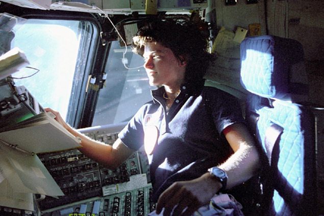
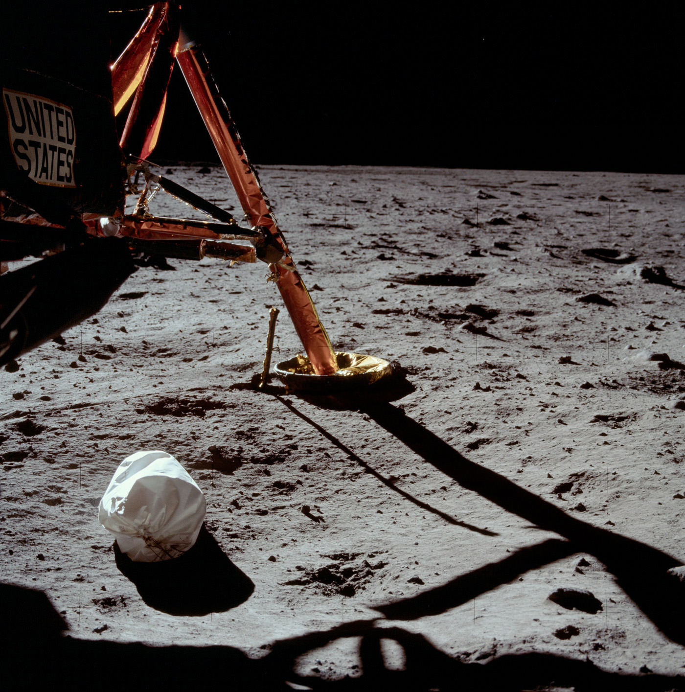
After this image, Armstrong took several more images of the surrounding landscape before fellow astronaut Edwin “Buzz” Aldrin, Jr. exited the module as well. The third man on the mission, Michael Collins, remained in lunar orbit piloting the command module Columbia.

The rest, as they say, is history.

Armstrong, as were all the Apollo mission astronauts, was trained in the use of a modified Hasselblad 500 EL camera, which took wonderfully detailed images on large-format film. Most of the photos they brought back have been high-quality scanned by Kipp Teague and are available online at the Apollo Image Gallery.

Today is the 43rd anniversary of the first lunar landing. More than just a page in the history books, it marks a shining moment for all of humanity when the combined ingenuity and courage of many, many people succeeded in the daunting task of, in President Kennedy’s words from May 25, 1961, “landing a man on the moon and returning him safely to Earth.”

Images: NASA. Scans by Kipp Teague.