Exoplanet Gliese 581g Makes the Top 5

Exoplanet Gliese 581g is back, and “officially” ranking #1 on a list of potentially habitable worlds outside of our solar system thanks to new research from the team that originally announced its discovery in 2010.

Orbiting a star 20 light-years away, the super-Earth is now listed alongside other exoplanets Gliese 667Cc, Kepler-22b, HD85512 and Gliese 581d in the University of Puerto Rico at Arecibo’s Habitable Exoplanets Catalog as good places to look for Earthlike environments… and thus the possibility of life.

First announced in September 2010 by a team led by Steven S. Vogt of UC Santa Cruz, the presence of Gliese 581g was immediately challenged by other astronomers whose data didn’t support its existence. Vogt’s team conducted further analysis of the Gliese system in which it appeared that the orbits of the planets were circular, rather than elliptical, and it was in this type of scenario that a strong signal for Gliese 581g once again appeared.

Read: Could Chance For Life on Gliese 581g Actually Be “100%”?

“This signal has a False Alarm Probability of < 4% and is consistent with a planet of minimum mass 2.2M [Earth masses], orbiting squarely in the star’s Habitable Zone at 0.13 AU, where liquid water on planetary surfaces is a distinct possibility” said Vogt.

And, located near the center of its star’s habitable “Goldilocks” zone and receiving about the same relative amount of light as Earth does, Gliese 581 g isn’t just on the list… it’s now considered the best candidate for being an Earthlike world — knocking previous favorite Gliese 667Cc into second place.

Read: Billions of Habitable Worlds Likely in the Milky Way

The announcement was made on the PHL’s press site earlier today by Professor Abel Méndez, Director of the PHL at UPR Arecibo.
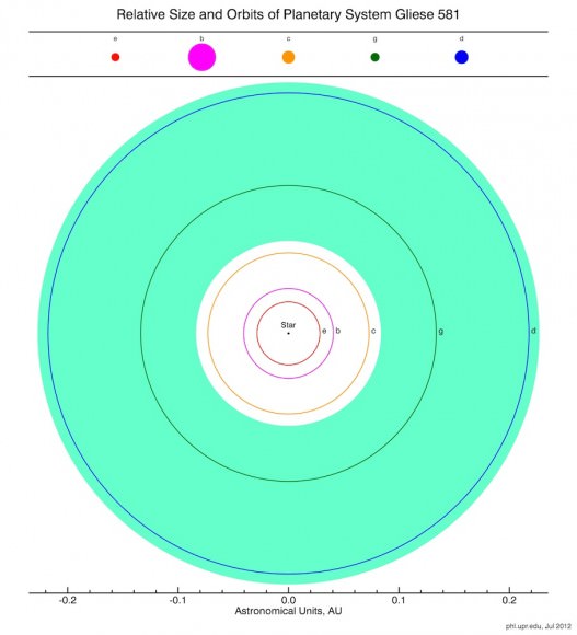
Diagram of the Gliese system. The green area is the habitable zone, where liquid water can exist on a planet’s surface. (PHL @ UPR Arecibo)

“The controversy around Gliese 581g will continue and we decided to include it to our main catalog based on the new significant evidence presented, and until more is known about the architecture of this interesting stellar system”

– Prof. Abel Méndez, UPR Arecibo

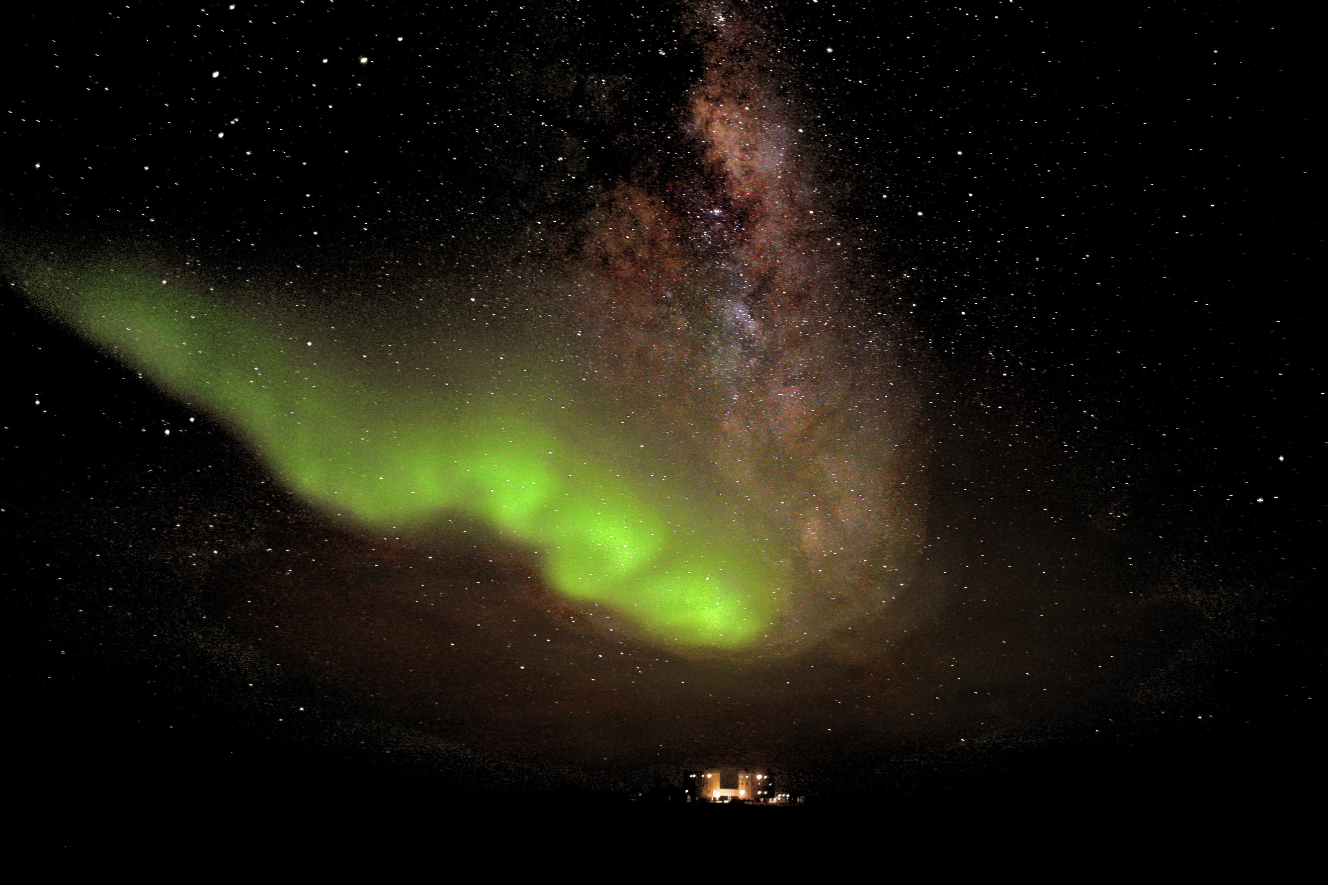
Aurora Over Antarctica: a “Teardrop From Heaven”

“We managed to snap a few photos before Heaven realised its mistake and closed its doors.”
– Dr. Alexander Kumar

This stunning photo of the Aurora Australis, set against a backdrop of the Milky Way, was captured from one of the most remote research locations on the planet: the French-Italian Concordia Base, located located at 3,200 meters (nearly 10,500 feet) altitude on the Antarctic plateau, 1,670 km (1,037 miles) from the geographic south pole.

The photo was taken on July 18 by resident doctor and scientist Dr. Alexander Kumar and his colleague Erick Bondoux.

Sparked by a coronal mass ejection emitted from active region 11520 on July 12, Earth’s aurorae leapt into high gear both in the northern and southern hemispheres three days later during the resulting geomagnetic storm — giving some wonderful views to skywatchers in locations like Alaska, Scotland, New Zealand… and even the South Pole.

“A raw display of one of nature’s most incredible sights dazzled our crew,” Dr. Kumar wrote on his blog, Chronicles from Concordia. “The wind died down and life became still. To me, it was if Heaven had opened its windows and a teardrop had fallen from high above our station, breaking the dark lonely polar night.

“We managed to snap a few photos before Heaven realised its mistake and closed its doors.”

With winter temperatures as low as -70ºC (-100ºF), no sunlight and no transportation in or out from May to August, Concordia Base is incredibly isolated — so much so that it’s used for research for missions to Mars, where future explorers will face many of the same challenges and extreme conditions that are found at the Base.

But even though they may be isolated, Dr. Kumar and his colleagues are in an excellent location to witness amazing views of the sky, the likes of which are hard to find anywhere else on Earth. Many thanks to them for braving the bitter cold and otherworldly environment to share images like this with us!

Read more on Concordia Base here.

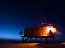
Lead image: ESA/IPEV/ENEAA/A. Kumar & E. Bondoux. Sub-image: sunset at Concordia. ESA/IPEV/PNRA – A. Kumar

CGI Movie From 1963 Shows Satellite Orbit

In what may very well be the world’s first computer-generated animation, this video shows the motion of a box-like “satellite” orbiting a rotating sphere… Pixar, eat your heart out.

Created in 1963 by Edward E. Zajac, a programmer at Bell Labs from 1954 to 1983, the animation was made to demonstrate a theoretical satellite that used gyroscopes to maintain an Earth-facing orientation. Only a year after the launch of Telstar 1, the world’s first communications satellite (which just had its 50th anniversary) Bell Labs was very much invested in the development of satellite technology.

According to the description on the ATT Tech YouTube channel:

Zajac programmed the calculations in FORTRAN, then used a program written by Zajac’s colleague, Frank Sinden, called ORBIT. The original computations were fed into the computer via punch cards, then the output was printed onto microfilm using the General Dynamics Electronics Stromberg-Carlson 4020 microfilm recorder. All computer processing was done on an IBM 7090 or 7094 series computer.

I’d like to say that many Bothans died to bring us this information but… well, I guess I just did.

Footage courtesy of AT&T Archives and History Center in Warren, NJ. H/T to Paul Caridad at VisualNews.com.

Bolt from the Blue: Giant Flash of Lightning Seen in Saturn’s Storm

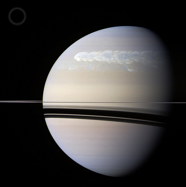
An enormous storm that wrapped its way around Saturn’s northern hemisphere during the first half of 2011 wasn’t just a churning belt of high-speed winds; it also generated some monster flashes of lightning as well — one of which was captured on camera by the Cassini spacecraft!

Check it out…


The image above was created from Cassini raw images acquired in red, green, and blue color channels and assembled to create a somewhat “true-color” image of Saturn. The image shows the storm as it looked on February 25, 2011, a couple of months after it was first noticed by amateur astronomers on the ground. (The circle at upper left illustrates the comparative size of Earth.)

Read: Studying Saturn’s Super Storm

These images were acquired by Cassini almost two weeks later, on March 6, the first showing a bright blue flash of lightning within the storm, along the eastern edge of a large eddy. The second image, taken 30 minutes later, does not have any visible flash.

Because the flash was only visible in blue light (and there was no red channel data) the images are false color. Near-infrared replaced the visible red channel.

Based on the image resolution (12 miles/20 km per pixel) the size of the lightning flash is estimated to be about 120 miles (200 km) wide — as large as the strongest lightning seen on Earth. And like on Earth, Saturn’s lightning is thought to originate deeper in the atmosphere, at the level where water droplets freeze.

Although the 2011 northern storm was a great feature to observe, this wasn’t the first time lightning had been spotted on Saturn. Cassini had observed flashes on the ringed planet in August of 2009 as well, allowing scientists to create the first movie of lightning flashing on another planet.

Since its arrival at Saturn in 2004, Cassini has detected 10 lightning storms on Saturn — although with up to 10 flashes per second and eventually covering an area of 2 billion square miles (4 billion sq. km) the 2011 storm was by far the largest ever seen.

Image credits: NASA / JPL-Caltech / Space Science Institute. Top composite by J. Major. Video: JPL

Why Doesn’t Earth Have More Water?

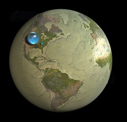
Water, water everywhere… Coleridge’s shipbound ancient mariners were plagued by a lack of water while surrounded by a sea of the stuff, and while 70% of Earth’s surface is indeed covered by water (of which 96% is salt water, hence not a drop to drink) there’s really not all that much — not when compared to the entire mass of the planet. Less than 1% of Earth is water, which seems odd to scientists because, based on conventional models of how the Solar System formed, there should have been a lot more water available in Earth’s neck of the woods when it was coming together. So the question has been floating around: why is Earth so dry?

According to a new study from the Space Telescope Science Institute in Baltimore, MD, the answer may lie in the snow.

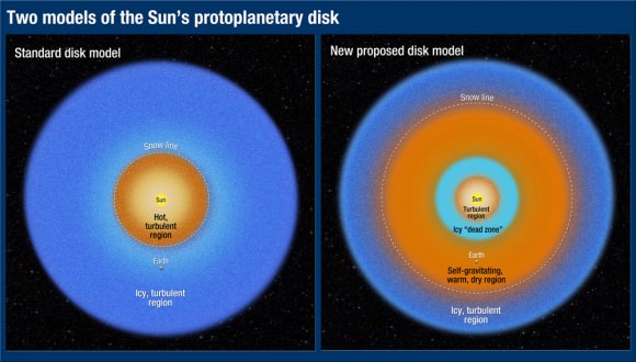
The snow line, to be exact. The region within a planetary system beyond which temperatures are cold enough for water ice to exist, the snow line in our solar system is currently located in the middle of the main asteroid belt, between the orbits of Mars and Jupiter. Based on conventional models of how the Solar System developed, this boundary used to be closer in to the Sun, 4.5 billion years ago. But if that were indeed the case, then Earth should have accumulated much more ice (and therefore water) as it was forming, becoming a true “water world” with a water mass up to 40 percent… instead of a mere one.

As we can see today, that wasn’t the case.
Planets such as Uranus and Neptune that formed beyond the snow line are composed of tens of percents of water. But Earth doesn’t have much water, and that has always been a puzzle.”

– Rebecca Martin, Space Telescope Science Institute 

A study led astrophysicists Rebecca Martin and Mario Livio of the Space Telescope Science Institute took another look at how the snow line in our solar system must have evolved, and found that, in their models, Earth was never inside the line. Instead it stayed within a warmer, drier region inside of the snow line, and away from the ice.

“Unlike the standard accretion-disk model, the snow line in our analysis never migrates inside Earth’s orbit,” Livio said. “Instead, it remains farther from the Sun than the orbit of Earth, which explains why our Earth is a dry planet. In fact, our model predicts that the other innermost planets, Mercury, Venus, and Mars, are also relatively dry. ”

Read: Rethinking the Source of Earth’s Water

The standard model states that in the early days of a protoplanetary disk’s formation ionized material within it gradually falls toward the star, drawing the icy, turbulent snow line region inward. But this model depends upon the energy of an extremely hot star fully ionizing the disk — energy that a young star, like our Sun was, just didn’t have.

“We said, wait a second, disks around young stars are not fully ionized,” Livio said. “They’re not standard disks because there just isn’t enough heat and radiation to ionize the disk.”


“Astrophysicists have known for quite a while that disks around young stellar objects are NOT standard accretion disks (namely, ones that are ionized and turbulent throughout),” added Dr. Livio in an email to Universe Today. “Disk models with dead zones have been constructed by many people  for many years. For some reason, however, calculations of the evolution of the snow line largely continued to use the standard disk models.”

Without fully ionized disk, the material is not drawn inward. Instead it orbits the star, condensing gas and dust into a “dead zone”  that blocks outlying material from coming any closer. Gravity compresses the dead zone material, which heats up and dries out any ices that exist immediately outside of it. Based on the team’s research it was in this dry region that Earth formed.

The rest, as they say, is water under the bridge.

The team’s results have been accepted for publication in the journal Monthly Notices of the Royal Astronomical Society.

Read the release on the Hubble news site here, and see the full paper here.

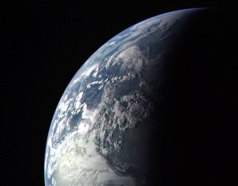
Lead image: Earth as seen by MESSENGER spacecraft before it left for Mercury in 2004. NASA/Johns Hopkins University Applied Physics Laboratory/Carnegie Institution of Washington. Disk model image: NASA, ESA, and A. Feild (STScI). Earth water volume image:  Howard Perlman, USGS; globe illustration by Jack Cook, Woods Hole Oceanographic Institution (©); Adam Nieman.

Postcards From The (Inner) Edge

As the world turns its gaze outward in anticipation of the arrival of Mars Science Laboratory — with its hair-raising “seven minutes of terror” landing — let’s take a moment to look back inward, where MESSENGER is still faithfully orbiting the first rock from the Sun, Mercury, and sending back images that could only have been imagined just a few years ago.

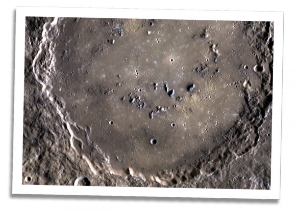
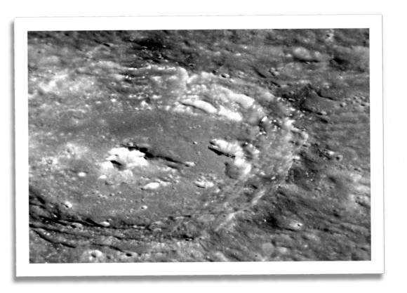
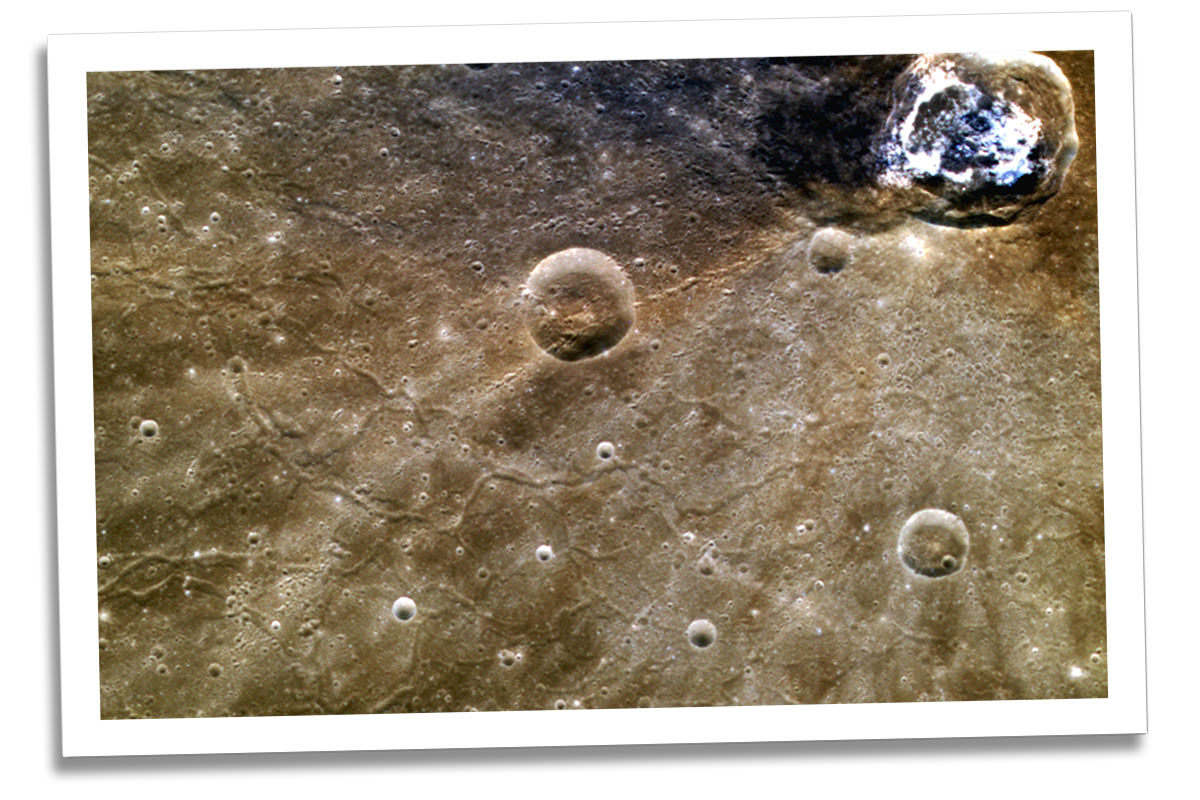
The image above shows the graben-gouged terrain around Balanchine crater, within Mercury’s vast Caloris Basin impact crater. Named for the co-founder of the New York City Ballet, Balanchine crater is 41 km (25.5 miles) in diameter and filled with the curious erosion features known as hollows. Graben — basically sunken troughs in the surface — are the result of extensional forces that have pulled sections of the planet’s upper crust apart.

This image shows the peak-ring structure located within the much larger crater Rustaveli, which is 180 km (112 miles) in diameter. One of the more recently-named craters (the IAU convention for new features on Mercury has them titled after renowned artists, writers and composers from history) Rustaveli is named for a 12th-century Georgian poet who wrote the epic “The Knight in the Panther’s Skin”. The crater that now bears his namesake is located on Mercury’s northern hemisphere.

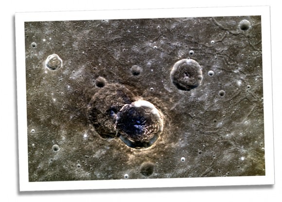
These two craters — also located within Caloris Basin — don’t yet have names but are no less interesting. Their overlapping positions works like an optical illusion, making the newer,sharper-edged crater on the right seem to almost float above the surface. The false-color of the image highlights the difference in surface composition of the two craters, which are both about 40 km (24 miles) wide. (The Caloris Basin in which they reside, however, is one of the largest known impact sites in our solar system, measuring at 1550 km — 963 miles — across!)

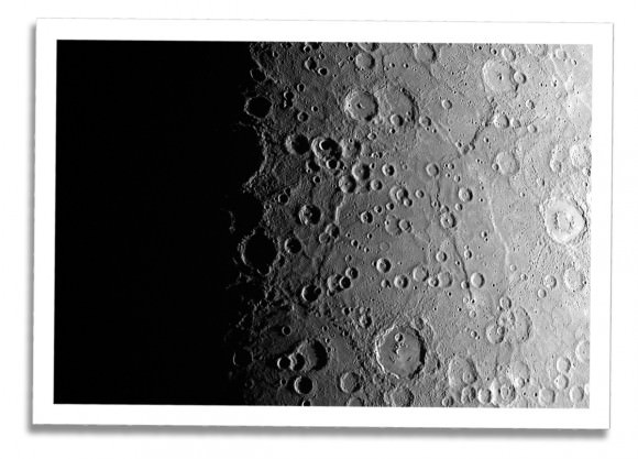
Now we zoom out for a wider view of our solar system’s second-densest planet (Earth is the first) and take a look at an image that’s night and day — literally! This is Mercury’s terminator, the twilit dividing line between night and day. More than just making a pretty picture, data on this transition is valuable to scientists as some atmospheric phenomena can only be observed at the terminator, such as the interaction between surface dust and charged particles from the Sun (which, at less than half the distance to the Sun than we are, Mercury is constantly bathed in.)

And now to zoom back in, we get a good look at an unnamed central-peaked crater about 85 km (52 miles) across in an oblique view  that highlights the hollows and depressions within its floor. Acquired as part of what’s called a “targeted observation”, high-resolution images like this (79 meters/pixel) allow scientists to closely investigate specific features — but sadly there’s just not enough mission time to image all of Mercury at this level of detail.

On March 17, 2011 (March 18, 2011, UTC), MESSENGER became the first spacecraft ever to orbit Mercury. The mission has provided the first data from Mercury since Mariner 10, over 30 years ago. After over 1,000 orbits, 98 percent of Mercury is now imaged in detail, allowing us to know more about our solar system’s innermost world than ever before.

Keep up with MESSENGER updates (and the latest images) on the mission website here.

Image credits: NASA/Johns Hopkins University Applied Physics Laboratory/Carnegie Institution of Washington

Expedition 32 Crew Lifts Off

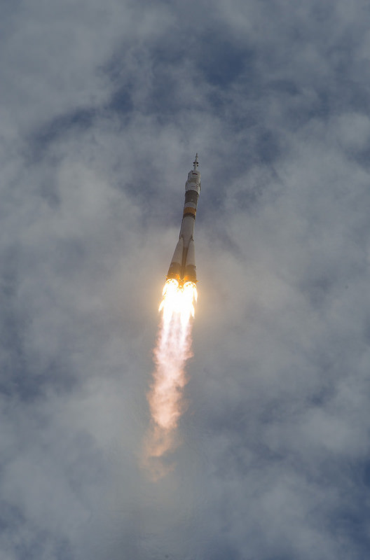
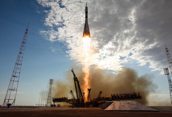
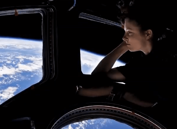
At 9:40 p.m. CDT a Soyuz TMA-05M rocket lifted off from the Baikonur Cosmodrome in Kazakhstan carrying Expedition 32 Commander Yuri Malenchenko, NASA Flight Engineer Sunita “Suni” Williams and JAXA Flight Engineer Akihiko Hoshide to the International Space Station. It was a beautiful launch on a hot summer day at the Cosmodrome — watch the video after the jump:

(My favorite part was when the Soyuz punched a hole in the clouds!)

Exact time of the launch was 9:40:3.91 CDT, docking with the ISS will occur on Monday at 11:52 p.m. CDT. Read more about the crew of Expedition 32 here.

Of historical note, the Expedition 32 launch occurred on the same day that the Apollo-Soyuz Test Project launched in 1975. Designed to test the compatibility of rendezvous and docking systems and the possibility of an international space rescue, the nine-day Apollo-Soyuz mission brought together two former spaceflight rivals: the United States and the Soviet Union. Without the success of that project, we might not have had an International Space Station in orbit today.


Images: NASA/Carla Cioffi. Video: NASA HD TV/Ustream

The Audacity to Dream

Making its debut at the TEDxISU (International Space University) event on July 6, the video above is an inspirational call-to-arms for anyone who’s ever looked to the stars and dreamed of a day when the sky was, in fact, not the limit. From Sputnik to Space Station, from Vostok to Virgin Galactic, the video reminds us of the spirit of adventure that unites us, regardless of time or place or politics. Dreaming, after all, is universal.

Check it out.

“A planet is the cradle of mind, but one cannot live in a cradle forever.”
– Konstantin Tsiolkovsky

Incoming! CME On Its Way Toward Earth

As you read this, a huge cloud of charged solar particles is speeding toward our planet, a coronal mass ejection resulting from the X1.4-class flare that erupted from sunspot 1520 on July 12. The CME is expected to collide with Earth’s magnetic field on Saturday, potentially affecting satellite operations and tripping alarms on power grids, as well as boosting auroral activity. It’s on its way, and all we can do is wait. (Thank goodness for magnetospheres!)

Actually, the effects from the incoming CME aren’t expected to be anything particularly dramatic. NOAA is predicting a geomagnetic storm level raging from G2 to G4, which although ranges from “moderate” to “severe” a G2 (Kp = 6) is most likely, according to Dr. C. Alex Young from NASA’s Goddard Space Flight Center.

[Read: What Is a CME?]

“A G2 level storm can cause some power fluctuations that may set off some voltage alarms for power companies,” Dr. Young told Universe Today. “Damage to transformers is possible for longer events, but unlikely. Satellite companies may have to make some orbit corrections for their satellites, and at higher latitudes where there are aurora they can be some disruption of high frequency radio broadcasts.

“All in all the effects should be minor,” he concluded.

And this may not be the last we hear from 1520, either.

“Its complexity has decreased but it is still large and has a ‘delta’ configuration,” added Dr. Young, “when there is opposite polarity magnetic field of the umbra within the penumbra of the sunspot. This is an unstable configuration that is indicative of larger releases of energy, lots of flares — in particular M and X flares.”

Below is a computer model of the CME from Goddard Space Weather Center. Impact with Earth is expected on 7/14 at 10:20 UT (+-7 hrs), 6:20 am EDT.

Auroras may be visible at lower latitudes this weekend, so check the NOAA’s updated auroral oval map to see if visibility extends into your area over the next several nights. Hopefully aurora photographers around the world will be able to get some great photos of a summer sky show!

You can keep up with the latest news on solar activity on Dr. Young’s blog, The Sun Today. And of course, stay tuned to Universe Today for more updates on any noteworthy space weather!

The video below uses SDO AIA footage in 131(teal), 171(gold) and 335 (blue) angstrom wavelengths, and shows the X1.4 class flare erupted from the center of the sun on July 12, 2012 at 12:52 PM EDT. Each wavelength shows different temperature plasma in the sun’s atmosphere. 171 shows 600,000 Kelvin plasma, 335 shows 2.5 million Kelvin plasma, and 131 shows 10 million Kelvin plasma. The final shot is a composite of 171 and 335 angstrom footage.

Top image: illustration of a CME about to impact Earth’s magnetosphere (NASA). Model animation: NASA/GSFC. Video courtesy NASA/SDO and the AIA science team.

UPDATE: The CME took a bit longer to arrive than expected, but impact with Earth’s magnetic field was detected at around 1800 UT (11 a.m. PDT/2 p.m. EDT), activating a geomagnetic storm. According to SpaceWeather.com: At the moment, conditions appear favorable for auroras over high-latitude places such as Canada, Scandinavia, Antarctica and Siberia. It is too early to say whether the storm will intensify and bring auroras to middle latitudes as well.

Sunspot 1520 Fires a Flare

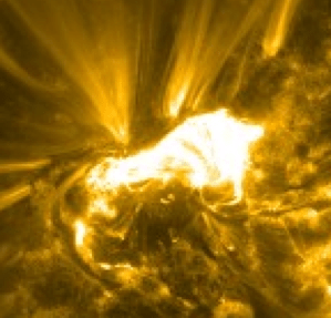
Remember that cool animation I posted earlier of AR1520 and how I said there’s no guarantee it wouldn’t unleash an X-class flare? Well at 16:48 UT today, it did. Just goes to show there’s no guarantees in space!

The X1.4-class flare will most likely affect Earth’s magnetic field as 1520 is directly facing us. Stay tuned for more!

Video & image: NASA/SDO and the AIA science team.

UPDATE: The CME associated with this flare is expected to impact Earth’s magnetosphere on Saturday between 3 and 5 p.m. EDT with “moderate to severe” activity possible. See an animated tracker here. (H/T to Francis Reddy at GSFC.) Also in the lineup for impact are MESSENGER and MSL.