Library of Congress Acquires Sagan’s Personal Collection, Thanks to Seth MacFarlane

Carl Sagan
Carl Sagan

Carl Sagan’s personal archive — a comprehensive collection of papers contained within 798 boxes — was delivered to the Library of Congress recently for sorting… thanks in no small part to “Family Guy” creator Seth MacFarlane. (Yes, you read that right.)

According to an article in the Washington Post yesterday by Joel Achenbach — who also got a chance to browse through several of the boxes — MacFarlane provided an “undisclosed sum of money” to the Library to purchase the collection from Sagan’s widow Ann Druyan, who had kept the papers preserved in storage at their home in Ithaca, NY.

As briefly reported in a previous article here on Universe Today, MacFarlane has been working to bring Sagan’s Cosmos series back to television, with Neil deGrasse Tyson reprising Sagan’s role. In fact it was Tyson who introduced MacFarlane to Druyan, and apparently got a peek at the astrophysicist’s impressive collection of papers, which “ranges from childhood report cards to college term papers to eloquent letters written just before his untimely death in 1996 at age 62.”

“He wasn’t a pack rat at all,” Druyan said. “But I think he had a sense of his place in cultural history. I think he knew he was corresponding with the great and the near-great both inside and outside of science.”

Also noted in the article are “files labeled F/C, for ‘fissured ceramics,’ Sagan’s code name for letters from crackpots.” How very Sagan.

The collection is spread out across tables inside a vast room in the Library of Congress’ Madison Building for organization, a process expected to take several months. The Library will announce its acquisition later today.

Read the full article here on the Washington Post.

As a fan of Carl Sagan, Cosmos, Neil Tyson and Seth MacFarlane… there’s really nothing to not like about this!

Pacific Glory

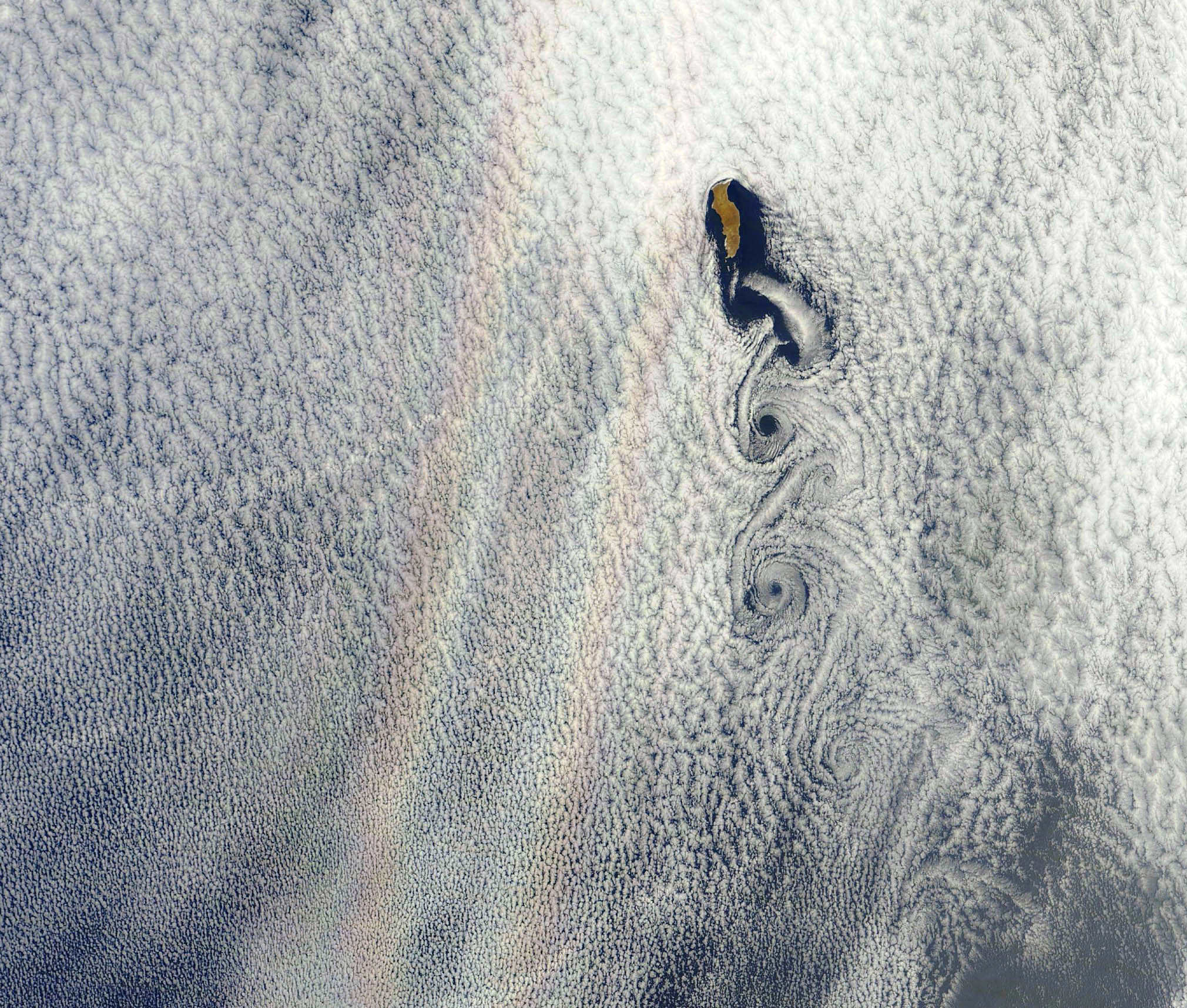
An optical phenomenon known as a “glory” is seen over a cloud-covered Pacific Ocean in this image from NASA’s Aqua satellite, acquired on June 20, 2012. Although the colors may make it look like a rainbow, the process behind its formation is somewhat different.

As vortices spiral off the leeward side of Guadalupe Island, off the western coast of Baja California, a shimmering spectrum of colors highlights a glory just west of the island. Glories are created when light from the Sun reflects back toward an observer off water droplets within clouds or fog. They are often seen from airplanes as a bright ring of light encircling a silhouetted shadow of the aircraft below, but are also visible from the ground and, sometimes, even from space.

From the NASA Earth Observatory website:

Although glories may look similar to rainbows, the way light is scattered to produce them is different. Rainbows are formed by refraction and reflection; glories are formed by backward diffraction. The most vivid glories form when an observer looks down on thin clouds with droplets that are between 10 and 30 microns in diameter. The brightest and most colorful glories also form when droplets are roughly the same size.

From the ground or an airplane, glories appear as circular rings of color. The space shuttle Columbia observed a circular glory from space in 2003. In the image above, however, the glory does not appear circular. That’s because MODIS scans the Earth’s surface in swaths perpendicular to the path followed by the satellite. And since the swaths show horizontal cross sections through the rings of the glory, the glory here appears as two elongated bands of color that run parallel to the path of the satellite, rather than a full circle.

Glories always appear around the spot directly opposite the Sun, from the perspective of the viewer. This spot is called the anti-solar point. To visualize this, imagine a line connecting the Sun, a viewer, and the spot where the glory appears. In this case, the anti-solar point falls about halfway between the two colored lines of the glory.

Click here to download the full-size image.

NASA image courtesy Jeff Schmaltz, LANCE MODIS Rapid Response. Read more here.

New “Flying Tea Kettle” Could Get Us To Mars in Weeks, Not Months

At 54.6 million km away at its closest, the fastest travel to Mars from Earth using current technology (and no small bit of math) takes around 214 days — that’s about 30 weeks, or 7 months. A robotic explorer like Curiosity may not have any issues with that, but it’d be a tough journey for a human crew. Developing a quicker, more efficient method of propulsion for interplanetary voyages is essential for future human exploration missions… and right now a research team at the University of Alabama in Huntsville is doing just that.

This summer, UAHuntsville researchers, partnered with NASA’s Marshall Space Flight Center and Boeing, are laying the groundwork for a propulsion system that uses powerful pulses of nuclear fusion created within hollow 2-inch-wide “pucks” of lithium deuteride. And like hockey pucks, the plan is to “slapshot” them with plasma energy, fusing the lithium and hydrogen atoms inside and releasing enough force to ultimately propel a spacecraft — an effect known as “Z-pinch”.

“If this works,” said Dr. Jason Cassibry, an associate professor of engineering at UAH, “we could reach Mars in six to eight weeks instead of six to eight months.”

Read: How Long Does It Take To Get To Mars?

The key component to the UAH research is the Decade Module 2 — a massive device used by the Department of Defense for weapons testing in the 90s. Delivered last month to UAH (some assembly required) the DM2 will allow the team to test Z-pinch creation and confinement methods, and then utilize the data to hopefully get to the next step: fusion of lithium-deuterium pellets to create propulsion controlled via an electromagnetic field “nozzle”.

Although a rocket powered by Z-pinch fusion wouldn’t be used to actually leave Earth’s surface — it would run out of fuel within minutes — once in space it could be fired up to efficiently spiral out of orbit, coast at high speed and then slow down at the desired location, just like conventional rockets except… better.

“It’s equivalent to 20 percent of the world’s power output in a tiny bolt of lightning no bigger than your finger. It’s a tremendous amount of energy in a tiny period of time, just a hundred billionths of a second.”

– Dr. Jason Cassibry on the Z-pinch effect

In fact, according to a UAHuntsville news release, a pulsed fusion engine is pretty much the same thing as a regular rocket engine: a “flying tea kettle.” Cold material goes in, gets energized and hot gas pushes out. The difference is how much and what kind of cold material is used, and how forceful the push out is.

Everything else is just rocket science.

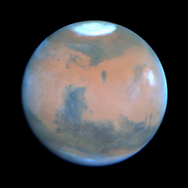
Read more on the University of Huntsville news site here and on al.com. Also, Paul Gilster at Centauri Dreams has a nice write-up about the research as well as a little history of Z-pinch fusion technology… check it out. Top image: Mars imaged with Hubble’s Wide-Field Planetary Camera 2 in March 1995.

Tropical Storm Debby Douses the Gulf

Satellite image of tropical storm "Debby" over the Gulf

The eastern Gulf of Mexico is getting lashed by tropical storm Debby, which whipped up tornado-spawning winds and dumped inches of rain across much of Florida, Mississippi, Alabama and southern Georgia over the weekend. NASA’s Aqua satellite acquired this image on June 23, just after the depression strengthened to full tropical storm status.

Born over the warm, moist air of the Gulf off the coast of Mississippi on Saturday afternoon, Debby quickly strengthened to storm status with sustained winds currently reported at over 60 mph. Slow-moving at a 6 mph crawl to the northeast, Debby continues to drench the Gulf state coasts with inches of rain — up to 10 to 20 inches projected for some areas. Major flooding has already become a problem and reports of tornadoes have been coming in since Sunday afternoon.

Debby will likely become a hurricane at some point, although her future path is still not entirely known.

Launched on May 4, 2002, NASA’s Aqua satellite specializes in keeping track of the movement of water around the planet in all its various forms. Find out more about the Aqua mission here.

Image: NASA/GSFC/Jeff Schmaltz/MODIS Land Rapid Response Team

Rivers of Rock

The Moon may not have ever had liquid water on its surface — despite the use of the term mare, Latin for “sea” and moniker for the large regions of darker material visible from Earth — but liquid did indeed flow on the Moon in ages past… liquid rock, briefly set loose by the impacts that formed its ubiquitous craters.

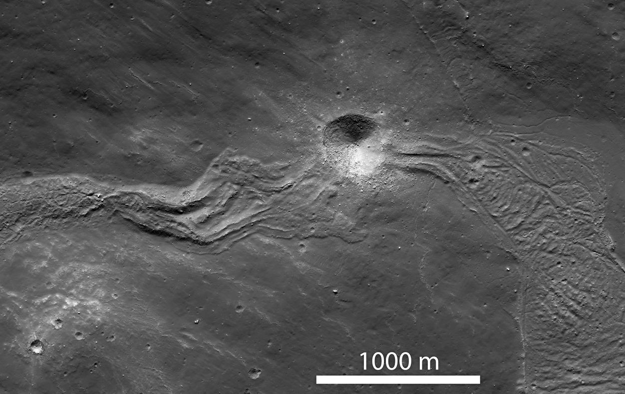
When large meteorites impacted the Moon, crust at the site would melt and get flung outwards, flowing downhill as rivers of rock and creating streams and pools of melted material before cooling and solidifying. There the rivers would remain, a permanently-hardened testament to the event that made them.

The image above, part of a NAC scan acquired by NASA’s Lunar Reconnaissance Orbiter on March 9, shows a solidified melt flow dating back to the creation of Tycho crater approximately 108 million years ago –which may sound like a long time but it’s actually very recent for large-scale lunar features.

The flow is interrupted by a younger, 400-meter-wide crater that impacted the lunar surface along its length. Since it punches through the melt flow as well as the local surface, it would be a great place for future astronaut geologists to explore!

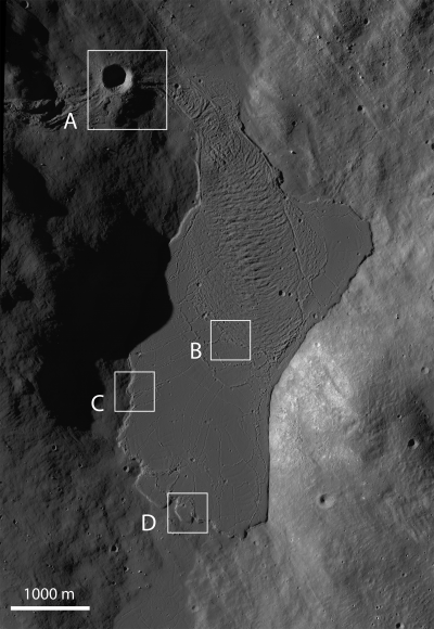
Taken under slightly different lighting conditions, the image below shows a large melt pond that the flow above terminates in. The pond is about 4500 meters long by 2100 meters across (2.8 x 1.3 miles).

Such images wouldn’t be possible without the awesome Lunar Reconnaissance Orbiter. Launched on June 18, 2009, LRO explores the lunar surface from an altitude of only 50 km (31 miles). Read more on the LRO site here.

Image credits: NASA/GSFC/Arizona State University

What is CERN?

Here’s another great video from Sixty Symbols featuring professor Ed Copeland giving his entertaining description of CERN, the “Mecca for physicists” and home of the famous Large Hadron Collider. (Hopefully it will tide you over until the latest news is presented on July 4 regarding the ongoing hunt for the ever-elusive Higgs field!) Enjoy.

“On each of these experiments there are something like 3,000 physicists involved. So they’re not all here at the same time, of course… the cafeteria would be a nightmare if that was the case.”

– Prof. Ed Copeland

Brilliant.

Mars Has Watery Insides, Just Like Earth

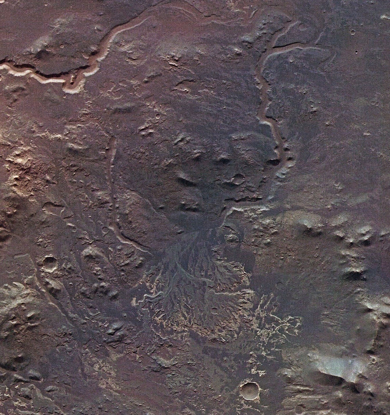
Researchers from the Carnegie Institution have found that water is present in surprisingly Earthlike amounts within Mars’ mantle, based on studies of meteorites that originate from the Red Planet. The findings offer insight as to how Martian water may have once made its way to the planet’s surface, as well as what may lie within other terrestrial worlds.

Earth has water on its surface (obviously) and also within its crust and mantle. The water content of Earth’s upper mantle — the layer just below the crust —  is between 50 and 300 ppm (parts per million). This number corresponds to what the research team has identified within the mantle of Mars, based on studies of two chunks of rock — called shergottites — that were blasted off Mars during an impact event 2.5 million years ago.

“We analyzed two meteorites that had very different processing histories,” said Erik Hauri, the analysis team’s lead investigator from the Carnegie Institute . “One had undergone considerable mixing with other elements during its formation, while the other had not. We analyzed the water content of the mineral apatite and found there was little difference between the two even though the chemistry of trace elements was markedly different. The results suggest that water was incorporated during the formation of Mars and that the planet was able to store water in its interior during the planet’s differentiation.”

The water stored within Mars’ mantle may have made its way to the surface through volcanic activity, the researchers suggest, creating environments that were conducive to the development of life.

Like Earth, Mars may have gotten its water from elements available in the neighborhood of the inner Solar System during its development. Although Earth has retained its surface water while that on Mars got lost or frozen, both planets appear to have about the same relative amounts tucked away inside… and this could also be the case for other rocky worlds.

“Not only does this study explain how Mars got its water, it provides a mechanism for hydrogen storage in all the terrestrial planets at the time of their formation,” said former Carnegie postdoctoral scientist Francis McCubbin, who led the study.

The team’s research is published in the July edition of the journal Geology. Read more on the Carnegie Institution for Science’s site here.

Image: The remains of what appears to be a river delta within Eberswalde crater on Mars, imaged by ESA’s Mars Express. Credit: ESA/DLR/FU Berlin (G. Neukum).

The “Deep Blue Sea” of the Sun

Looking like an intricate pen-and-ink illustration, the complex and beautiful structures of the Sun’s surface come to life in yet another stunning photo by Alan Freidman, captured from the historic Mount Wilson Observatory near Los Angeles, California.

Click below for the full-size image in all its hydrogen alpha glory.


An oft-demonstrated master of solar photography, Alan took the image above while preparing for the transit of Venus on June 5 — which he also skillfully captured on camera (see a video below).

Hydrogen is the most abundant element found on the sun. The sun’s “surface” and the layer just above it — the photosphere and chromosphere, respectively — are regions where atomic hydrogen exists profusely in upper-state form. It’s these absorption layers that hydrogen alpha imaging reveals in detail.

The images above are “negatives”… check out a “positive” version of the same image here.

” The seeing was superb… definitely the best of the visit and among the best solar conditions I’ve ever experienced,” Alan writes on his blog.

The video below was made by Alan on June 5, showing Venus transiting the Sun while both passed behind a tower visible from the Observatory.

Alan’s work is always a treat… see more of his astrophotography on his website AvertedImagination.com.

Image © Alan Friedman. All rights reserved.

Blue Marble 2012: The Arctic Edition

This latest portrait of Earth from NASA’s Suomi NPP satellite puts the icy Arctic in the center, showing the ice and clouds that cover our planet’s northern pole. The image you see here was created from data acquired during fifteen orbits of Earth.

In January of this year Suomi NPP images of Earth were used to create an amazing “Blue Marble” image that spread like wildfire across the internet, becoming one of the latest “definitive” images of our planet. Subsequent images have been released by the team at Goddard Space Flight Center, each revealing a different perspective of Earth.

See a full-sized version of the image above here.

NASA launched the National Polar-orbiting Operational Environmental Satellite System Preparatory Project (or NPP) on October 28, 2011 from Vandenberg Air Force Base. On Jan. 24, NPP was renamed Suomi National Polar-orbiting Partnership, or Suomi NPP, in honor of the late Verner E. Suomi. It’s the first satellite designed to collect data to improve short-term weather forecasts and increase understanding of long-term climate change.

Suomi NPP orbits the Earth about 14 times each day and observes nearly the entire surface of the planet.

Image credit: NASA/GSFC/Suomi NPP


Milky Way to Concordia Base… Come In, Concordia Base…

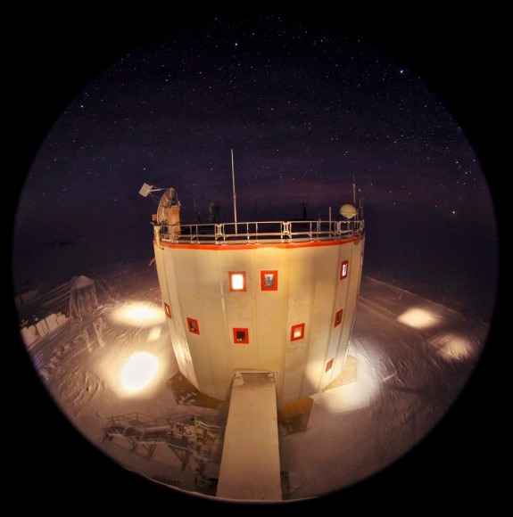
This stunning photo of the Milky Way was captured from what may be the coldest and most isolated research facility on Earth: the French-Italian Concordia Base station, located at 3,200 meters (nearly 10,500 feet) altitude on the Antarctic plateau, 1,670 km (1,037 miles) from the geographic south pole.

Taken by Dr. Alexander Kumar, a doctor, researcher and photographer who’s been living at the Base since January, the image shows the full beauty of the sky above the southern continent — a sky that doesn’t see the Sun from May to August.

During the winter months no transportation can be made to or from Concordia Base — no deliveries or evacuations, not for any reason. The team there is truly alone, very much like future space explorers will one day be. This isolation is one reason that Concordia is used by ESA for research for missions to Mars.

Of course, taking photos outside is no easy task. Temperatures outside the Base in winter can drop down to -70ºC (-100ºF)!

 Still, despite the isolation, darkness and cold, Dr. Kumar finds inspiration in his surroundings.

“The dark may cause fear, but if you take the time to adapt and look within it, you never know what you may find – at the bottom of the ocean, in the night sky, or under your bed in the middle of the night,” writes Kumar on the Concordia blog. “If you don’t overcome your fear of the ‘unknown’ and ‘monsters’, you will never see marvellous secrets hidden in the dark.

“I hope this photo inspires you too for the days, weeks and months ahead. In terms of the space exploration we are only beginning. We have to continue pushing out into the great beyond.”

Read more of the “Chronicles from Concordia” here.

 Image credits: ESA/IPEV/PNRA – A. Kumar