A graphic designer in Rhode Island, Jason writes about space exploration on his blog Lights In The Dark, Discovery News, and, of course, here on Universe Today. Ad astra!
Changing seasons in Mars’ northern hemisphere brings a change in the weather, and the clouds have rolled in to cover part of the polar surface in this intriguing image from the Mars Odyssey spacecraft.
Mars Odyssey’s THEMIS visual imager (VIS) captured this image on Jan. 24, 2012, as it passed over the Red Planet’s northern pole during one of its 2-hour-long orbits.
Is this the best video footage ever of photos taken from the International Space Station? ISS astronaut and Expedition 29 commander Mike Fossum seems to think so.
If anyone would know what a good ISS video is, he would! So watch, and decide for yourself.
Video uploaded by YouTube user bitmeizer. Made from sequences of still photographs taken by Expedition 29 crew members, the time-lapse videos have been digitally smoothed out and a soundtrack added, along with some transition effects.
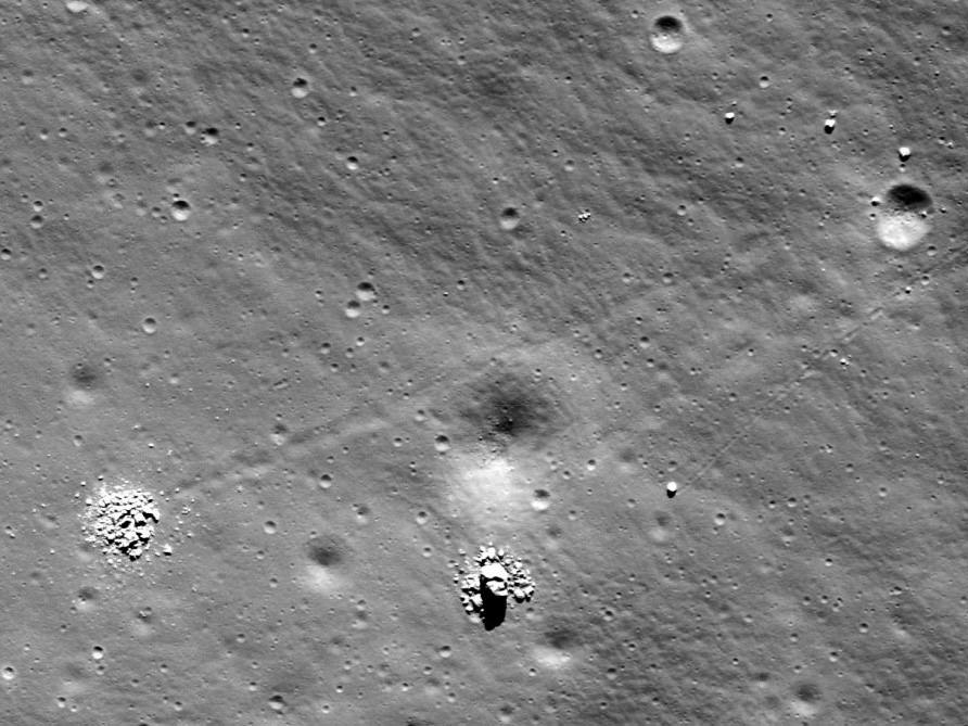
The remains of crumbled boulders in Schiller crater (NASA/GSFC/Arizona State University)
[/caption]
Breaking up may be hard to do, but these two lunar boulders seem to have succeeded extremely well! Imaged by the Lunar Reconnaissance Orbiter Camera (LROC) in October of 2009, this crumbled couple was recently identified by Moon Zoo team member Dr. Anthony Cook and brought to the attention of the project’s forum moderator.
The tracks left in the regolith — lunar soil — behind the boulders tell of their past rolling journeys down the slope of the elongated Schiller crater, in which they reside. Rolling boulders have been spotted before on the Moon, but what made these two split apart? And…why does that one on the lower right look so much like half a face?
Several things can cause lunar boulders to come loose and take the nearest downhill course. Meteorite impacts can shake the ground locally, giving the rocks enough of a nudge to set them on a roll. And moonquakes — the lunar version of earthquakes, as the name implies (although not due to tectonic plate shifts but rather to more mysterious internal lunar forces) — can also dislodge large boulders.
The low gravity on the Moon can make large rocks take a bounding path, evidenced by the dotted-line appearance of some of the trails.
Could all that bounding and bouncing have made the two boulders above shatter apart? Or was something else the cause of their crumbling?
Dr. Cook suggested that the boulders could have fractured before they began rolling, and then the added stress of their trip down the crater’s slope (uphill is to the right) made them break apart at the end of their trip… possibly due to further weathering and the extreme temperature variations of lunar days and nights.
Although a sound idea, Dr. Cook added, “I’m a bit puzzled though why the one on the top left has rock debris so far away from the centre. The boulder that looks like a skull rock on the bottom right has debris a lot closer to it, that could simply be explained by bits falling off as one would expect from the explanation above.”
This is one rock that's not happy about its breakup!
Another idea is that the boulders were struck by meteorites, but it seems extremely improbable that two would have been hit right next to each other. Still, not impossible, especially given the geologic time spans in play.
And as far as the “skull rock” boulder is concerned… that’s a little something called pareidolia, the tendency for our brains to interpret random shapes as something particularly significant. In this case it’s a human face, one of the most popular forms of pareidolia (perhaps best known by the famous “Face on Mars”, which, as we all now know, has been since shown to be just another Martian mesa.)
It does look like a face though, and not a particularly happy one!
Find out more about rolling boulders and Schiller crater on the LROC site hosted by Arizona State University here, and take a look at the full image scan of the region yourself… you may find more of these broken-up rolling rocks!
LROC WAC global 100-meter mosaic image of the 180-km long, 70-km wide Schiller crater. Overlaid onto a laser altimetry elevation model. (NASA/GSFC/Arizona State University)
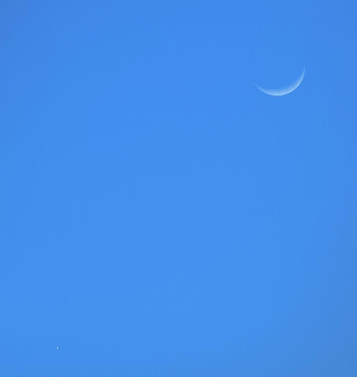
As promised by Nancy in a previous article on Universe Today, Venus was visible during the daylight hours this Saturday, very close to the crescent Moon. If you had clear weather you may have been able to catch a glimpse of the scene above, photographed from my location in north Texas at 6:35 p.m. local time.
Dim but visible, Venus is the “star” at lower left.
Later that same evening the show really went into full force as the Moon was illuminated by Earthshine in the western sky, with Venus ablaze and Jupiter making a bright appearance as well!
Nancy wrote on Feb. 24: If you don’t see Venus during the day, try to see Venus immediately at sunset; and right now, the Moon, Venus and Jupiter are lining up for triple conjunction at dusk, and with clear skies, it will be a great view that is almost impossible to miss!
A great view indeed! I grabbed a quick shot with my iPhone camera of the conjunction, and took the opportunity to point out the view to some neighbors as well.
Conjunction of the Moon, Venus and Jupiter on Feb. 25, 2012. (Jason Major)
One of the more dramatic planetary conjunctions I’ve seen, especially with the light from a fading sunset illuminating the stage.
Sometimes the best astronomy is the type you can see with your own eyes… and be able to easily share with others!
ADDED 2/26: Sunday evening brought some great views as well! Here’s a photo from around 6:45 pm on Feb. 26th:
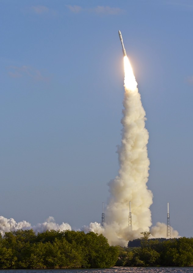
Feb. 24, 2012 launch of Atlas V with MUOS-1. Credit: Jen Scheer (@flyingjenny)
[/caption]
On the afternoon of February 24, 2012, at 5:15 p.m. EST local time, a United Launch Alliance Atlas V rocket lifted off from the pad at Cape Canaveral Air Force Base carrying in its payload the US Navy’s next-generation narrowband communications satellite MUOS-1. After two scrubbed launches the previous week due to weather, the third time was definitely a charm for ULA, and the launch went nominally (that’s science talk for “awesome”.)
But what made that day, that time the right time to launch? Do they just like ending a work week with a rocket launch? (Not that I could blame them!) And what about the weather… why go through the trouble to prepare for a launch at all if the weather doesn’t look promising? Where’s the logic in that?
As it turns out, when it comes to launches, it really is rocket science.
There are a lot of factors involved with launches. Obviously all the incredible engineering it takes to even plan and build a launch vehicle, and of course its payload — whatever it happens to be launching in the first place. But it sure doesn’t end there.
Launch managers need to take into consideration the needs of the mission, where the payload has to ultimately end up in orbit… or possibly even beyond. Timing is critical when you’re aiming at moving targets — in this case the targets being specific points in space (literally.) Then there’s the type of rocket being used, and where it is launching from. Only then can weather come into the equation, and usually only at the last minute to determine if the countdown will proceed before the launch window closes.
How big that launch window may be — from a few hours to a few minutes — depends on many things.
Kennedy Space Center’s Anna Helney recently assembled an article “Aiming for an Open Window” that explains how this process works:
_________________
The most significant deciding factors in when to launch are where the spacecraft is headed, and what its solar needs are. Earth-observing spacecraft, for example, may be sent into low-Earth orbit. Some payloads must arrive at a specific point at a precise time, perhaps to rendezvous with another object or join a constellation of satellites already in place. Missions to the moon or a planet involve aiming for a moving object a long distance away.
For example, NASA’s Mars Science Laboratory spacecraft began its eight-month journey to the Red Planet on Nov. 26, 2011 with a launch aboard a United Launch Alliance (ULA) Atlas V rocket from Cape Canaveral Air Force Station in Florida. After the initial push from the powerful Atlas V booster, the Centaur upper stage then sent the spacecraft away from Earth on a specific track to place the laboratory, with its car-sized Curiosity rover, inside Mars’ Gale Crater on Aug. 6, 2012. Due to the location of Mars relative to Earth, the prime planetary launch opportunity for the Red Planet occurs only once every 26 months.
Additionally, spacecraft often have solar requirements: they may need sunlight to perform the science necessary to meet the mission’s objectives, or they may need to avoid the sun’s light in order to look deeper into the dark, distant reaches of space.
A Delta II arcs across the sky carrying NASA's Suomi NPP spacecraft. Image credit: NASA/Bill Ingalls
Such precision was needed for NASA’s Suomi National Polar-orbiting Partnership (NPP) spacecraft, which launched Oct. 28, 2011 aboard a ULA Delta II rocket from Vandenberg Air Force Base in California. The Earth-observing satellite circles at an altitude of 512 miles, sweeping from pole to pole 14 times each day as the planet turns on its axis. A very limited launch window was required so that the spacecraft would cross the ascending node at exactly 1:30 p.m. local time and scan Earth’s surface twice each day, always at the same local time.
All of these variables influence a flight’s trajectory and launch time. A low-Earth mission with specific timing needs must lift off at the right time to slip into the same orbit as its target; a planetary mission typically has to launch when the trajectory will take it away from Earth and out on the correct course.
According to [Eric Haddox, the lead flight design engineer in NASA’s Launch Services Program], aiming for a specific target — another planet, a rendezvous point, or even a specific location in Earth orbit where the solar conditions will be just right — is a bit like skeet shooting.
“You’ve got this object that’s going to go flying out into the air and you’ve got to shoot it,” said Haddox. “You have to be able to judge how far away your target is and how fast it’s moving, and make sure you reach the same point at the same time.”
But Haddox also emphasized that Earth is rotating on its axis while it orbits the sun, making the launch pad a moving platform. With so many moving players, launch windows and trajectories must be carefully choreographed.
__________________
It’s a fascinating and complex set of issues that mission managers need to get just right in order to ensure the success of a launch — and thus the success of a mission, whether it be putting a communication satellite into orbit or a rover onto Mars… or somewhere much, much farther than that.
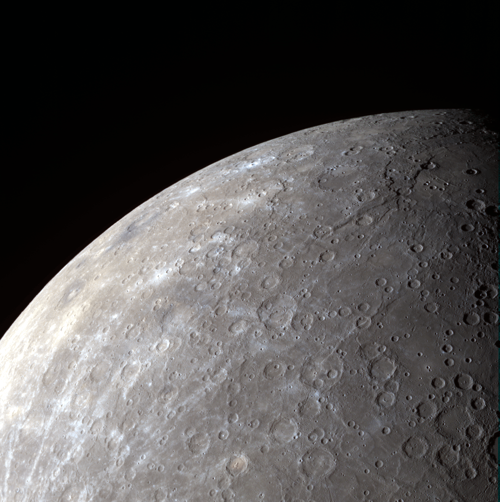
MESSENGER wide-angle camera image of Mercury's southern hemisphere.
[/caption]
NASA’s MESSENGER spacecraft, about to wrap up its first full year in orbit around Mercury, captured this view of the planet’s heavily-cratered southern hemisphere on August 28, 2011. Because of its orbit, MESSENGER gets particularly good panoramic views of Mercury’s underside.
Here’s why…
MESSENGER’s orbit, established on March 18, 2011 at 00:45 UTC, is not a simple circling path around the first rock from the Sun. Instead it is highly elliptical, bringing it 124 miles (200 km) above Mercury’s north pole at its closest and more than 9,420 miles (15,193 km) from its south pole at its farthest! (See diagram below.)
The close approaches over the northern hemisphere allow MESSENGER to study the Caloris basin, Mercury’s largest surface feature and, at over 960 miles (1,550 km) across, one of the largest impact craters in the entire Solar System.
The view of Mercury’s southern hemisphere above features some notable craters as well: the relatively youthful 444-mile (715-km) -wide Rembrandt basin is seen at top right, while the smaller pit-floor crater Kipling can be discerned to its left, just below the planet’s limb.
When craters are larger than 300 km in diameter, they are referred to as basins.
During its 12 months in orbit MESSENGER will have experienced only two days on Mercury! This is because Mercury rotates very slowly on its axis, completing a full solar day (sunrise to sunrise) every 176 Earth days. (And you thought your work day seemed to last forever!)
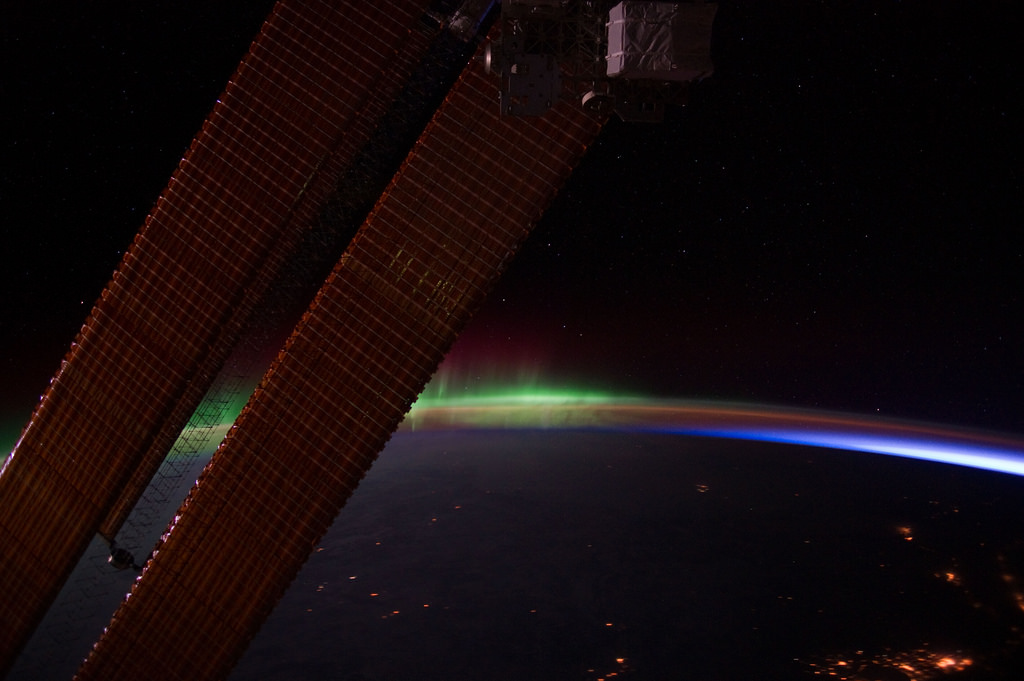
Here’s a gorgeous view from the International Space Station, taken by the Expedition 30 crew on Feb. 4, 2012 as the station passed into orbital dawn. The greens and reds of the aurora borealis shimmer above Earth’s limb beyond the Station’s solar panels as city lights shine beneath a layer of clouds.
As the ISS travels around the planet at 17,500 mph (28,163 km/h) it moves in and out of daylight, in effect experiencing dawn 16 times every day.
From that vantage point, 240 miles (386 km) above the Earth, the lights of the aurora — both northern and southern — appear below, rather than above.
See this and more images from the Space Station’s nightly flights here.
Also, here’s a time-lapse video made from photos taken by the Expedition 30 crew a few days earlier. Enjoy!
(Video courtesy of the Image Science & Analysis Laboratory, NASA Johnson Space Center.)
Tendrils of ice particles, called frazil, extend out into Antarctica's Mackenzie Bay. (NASA/EO-1 - ALI)
[/caption]
Ghostly green tendrils drift out into Mackenzie Bay off the coast of eastern Antarctica in this image, acquired by NASA’s Earth-Observing (EO-1) satellite on Feb. 12, 2012.
The tendrils are made of fine particles of ice called frazil, the result of upwelling cold water from deep beneath the Amery ice shelf.
Sea water flowing in currents under the Amery ice shelf gets cooled to temperatures below freezing, the result of greater water pressures existing at depth. As some of the water rises and flows along the underside of the shelf toward the open ocean, it gradually encounters less pressure since the ice thickness decreases the further away from shore it extends.
When the supercold water approaches the surface where pressure is lowest, it instantly freezes, forming needle-like ice particles called frazil.
Only 3 -4 millimeters wide, the frazil crystals can still be concentrated enough to be visible from orbit as it drifts into the bay, flowing around icebergs as it is carried along by wind and currents. (The largest iceberg in the image is a little over 4 km/2.5 miles long.)
Eventually the warmer surface water that surrounds the southern continent melts the frazil, and the tendrils fade away.
Scheduled to fly for a year and only designed to last a year and a half, EO-1 celebrated its eleventh anniversary on November 21, 2011. During its time in orbit the satellite has accomplished far more than anyone dreamed, and its Earth-observing mission continues on. Read more on the EO-1 site here.
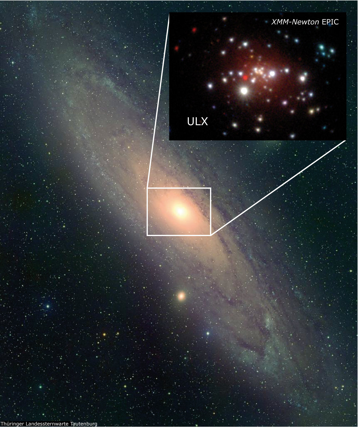
This image shows the central region of the Andromeda galaxy in X-rays, where the newly discovered ULX outshines all other sources. Image: Landessternwarte Tautenburg, XMM-Newton, MPE
[/caption]
An ultraluminous x-ray source (ULX) previously spotted in the neighboring Andromeda galaxy by NASA’s Chandra observatory has now been revealed to be a stellar-mass black hole, according to researchers at the Max Planck Institute for Extraterrestrial Physics.
The black hole was the first ULX seen in Andromeda, as well as the closest ever observed.
Ultraluminous x-ray sources are rare objects, observed in the near and distant Universe in the outer regions of galaxies. Typically only one or two ULXs are seen in any one particular galaxy — if there are any seen at all.
The large distances to ULXs makes detailed observations difficult, and so their exact causes have been hard to nail down.
This particular x-ray source was first identified in late 2009 by Chandra and was followed up with observations by Swift and Hubble. Classified by researchers at the Max Planck Institute as a low-luminosity source, it actually outshined the entire Andromeda galaxy in x-ray luminosity!
Continued observations with Chandra and ESA’s XMM-Newton showed behavior similar to known x-ray sources in our own Milky Way galaxy: actively feeding black holes.
“We were very lucky that we caught the ULX early enough to see most of its lightcurve, which showed a very similar behavior to other X-ray sources from our own galaxy,” said Wolfgang Pietsch from the Max Planck Institute for Extraterrestrial Physics. The emission decayed exponentially with a characteristic timescale of about one month, which is a common property of stellar mass X-ray binaries. “This means that the ULX in Andromeda likely contains a normal, stellar black hole swallowing material at very high rates.”
It’s estimated that the black hole is at least 13 times the mass of the Sun.
Continued observations of the ULX/black hole will attempt to observe another outburst similar to the 2009 event, although if this black hole is anything like those observed in our galaxy it could be years before another such event occurs. Still, our relatively clear view of the Andromeda galaxy unobscured by intervening dust and gas offers a chance to perhaps spot other potential x-ray sources residing there.
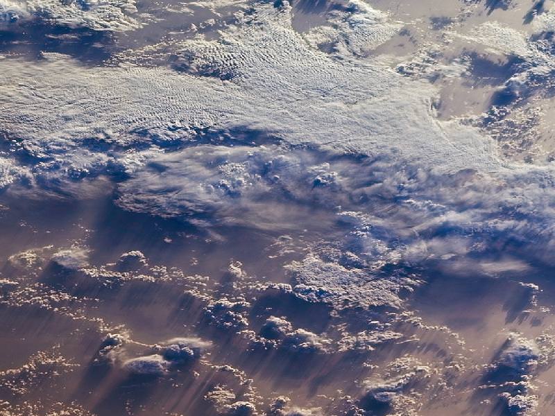
Clouds over the southern Indian Ocean, July 23, 2007. (NASA/JPL-Caltech)
[/caption]
Ok, maybe not the sky itself… but the clouds. According to recent research by climate scientists in New Zealand, global cloud heights have dropped.
Researchers at The University of Auckland have reported a decreasing trend in average global cloud heights from 2000 to 2010, based on data gathered by the Multi-angle Imaging SpectroRadiometer (MISR) on NASA’s Terra satellite. The change over the ten-year span was 30 to 40 meters (about 100 to 130 feet), and was mostly due to fewer clouds at higher altitudes.
It’s suspected that this may be indicative of some sort of atmospheric cooling mechanism in play that could help counteract global warming.
“This is the first time we have been able to accurately measure changes in global cloud height and, while the record is too short to be definitive, it provides just a hint that something quite important might be going on,” said lead researcher Professor Roger Davies.
A steady reduction in cloud heights could help the planet radiate heat into space, thus serving as a negative feedback in the global warming process. The exact cause of the drop in cloud altitude is not yet known, but it could reasonably be resulting from a change in circulation patterns that otherwise form high-altitude clouds.
Rendering of the Terra spacecraft. (NASA)
Cloud heights are just one of the many factors that affect climate, and until now have not been able to be measured globally over a long span of time.
“Clouds are one of the biggest uncertainties in our ability to predict future climate,” said Davies. “Cloud height is extremely difficult to model and therefore hasn’t been considered in models of future climate. For the first time we have been able to accurately measure the height of clouds on a global basis, and the challenge now will be to incorporate that information into climate models. It will provide a check on how well the models are doing, and may ultimately lead to better ones.”
While Terra data showed yearly variations in global cloud heights, the most extreme caused by El Niño and La Niña events in the Pacific, the overall trend for the years measured was a decrease.
Continuing research will be needed to determine future trends and how they may impact warming.
“If cloud heights come back up in the next ten years we would conclude that they are not slowing climate change,” Davies said. “But if they keep coming down it will be very significant.”
The team’s study was recently published in the journal Geophysical Research Letters.
Terra is a multi-national, multi-disciplinary mission involving partnerships with the aerospace agencies of Canada and Japan. An important part of NASA’s Science Mission, Terra is helping scientists around the world better understand and protect our home planet.