A graphic designer in Rhode Island, Jason writes about space exploration on his blog Lights In The Dark, Discovery News, and, of course, here on Universe Today. Ad astra!
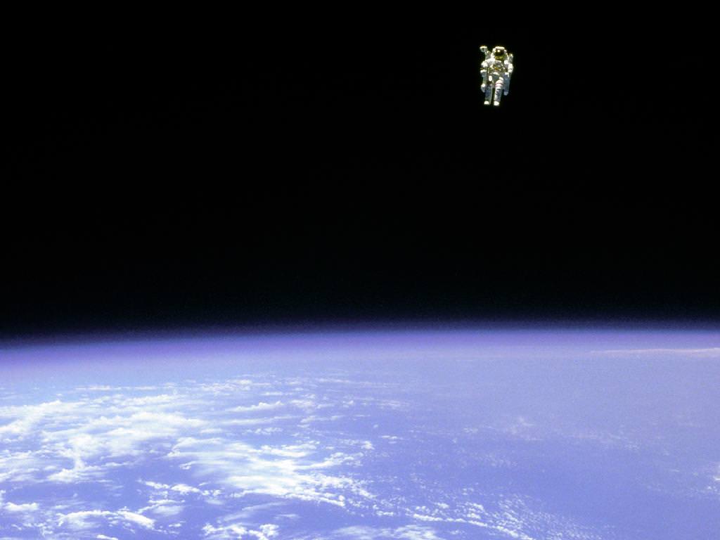
Astronaut Bruce McCandless untethered above the Earth on Feb. 12, 1984. (NASA)
[/caption]
28 years ago today, NASA astronaut Bruce McCandless left the relative safety of Challenger’s payload bay and went untethered into orbit around Earth, venturing farther than anyone ever before.
The historic photo above was taken when McCandless was 320 feet from the orbiter — about the length of an American football field, or just shy of the width of the International Space Station.
The free-flying endeavor was possible because of McCandless’ nitrogen-powered jet-propelled backpack, called a Manned Maneuvering Unit (MMU). It attached to the space suit’s life-support system and was operated by hand controls, allowing untethered access to otherwise inaccessible areas of the orbiter and was also used in the deployment, service and retrieval of satellites.
Astronaut Dale Gardner using the MMU during STS-51A in Nov. 1984 to travel to the Westar VI satellite. (NASA)
The MMU used a non-contaminating nitrogen propellant that could be recharged in the orbiter. It weighed 140 kg (308 lbs) and has a built-in 35mm camera.
After the Challenger disaster, the MMU was deemed too risky and was discontinued. But for a brief period of time in the early ’80s, humans had the means for really “soaring to new heights”.
Animation of AR1416's evolution over the past several days (SDO/HMI)
[/caption]
The latest sunspot region to traverse the face of the Sun has nearly doubled in size as it aims Earthward, as seen in the animation above from NASA’s Solar Dynamics Observatory. (Click image to play the animation.)
This is the second day in a row that the region has been seen expanding.
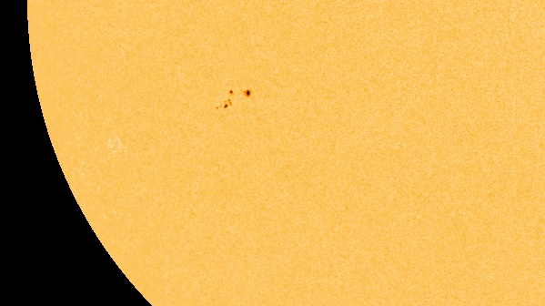
According to SpaceWeather.com, active region 1416 has the right sort of magnetic energy to potentially send M-class flares our way.
M-class flares are medium-sized solar flares. They can cause brief radio blackouts that affect Earth’s polar regions. Minor radiation storms sometimes follow an M-class flare event.
Sunspot region 1416 on Feb. 11, 2012. The large sunspot on the right is easily the size of Earth. (SDO/HMI Intensitygram)
If AR1416 produces a flare over the next 24 hours we would likely see increased auroral activity in upper latitudes early next week.
Stay tuned to Universe Today and SpaceWeather.com for any news on solar flares, and be sure to visit the SDO site for the latest images and videos of our home star.
Images courtesy NASA/SDO and the AIA and HMI science teams.
____________________
Also, check out Alan Boyle’s article on MSNBC’s Cosmic Log about this and a recent heart-shaped coronal mass ejection that occurred on Friday, sending a cloud of charged particles on a Valentine’s Day date with our magnetosphere. It should be a Sun-kissed night in northern parts of the world!
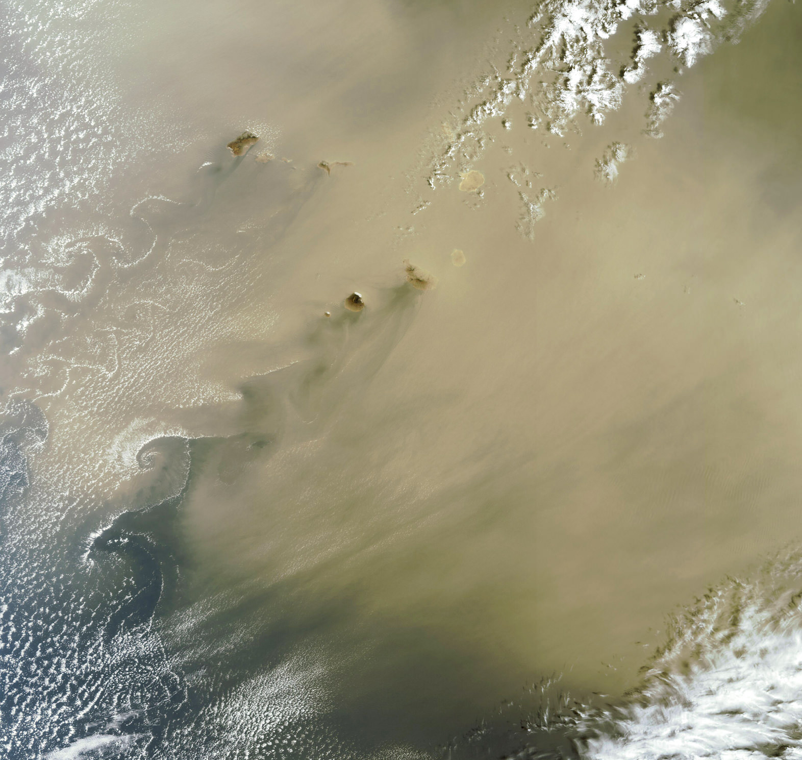
Dust from the Sahara blows past the Cape Verde islands on Feb. 9, 2012 (Chelys)
[/caption]
Thick dust from the Sahara blowing over the ocean off the western coast of Africa encounters the islands of Cape Verde, forming a wake of swirling “vortex streets” visible by satellite.
These swirls are also known as von Karman vortices. When wind encounters the island, the disturbance in the flow propagates downwind in the form of a double row of vortices, which alternate their direction of rotation.
Such effects can be seen anywhere a liquid fluid — including air — flows around a solid body. They are named after engineer and fluid dynamicist Theodore von Kármán.
In the image above, the dust and sand is thick enough to nearly block out some of the islands entirely. See the full scale version here on the Chelys “EOSnap” Earth Snapshot site.
Image via EOSnap/Chelys SRRS (Satellite Rapid Response System).
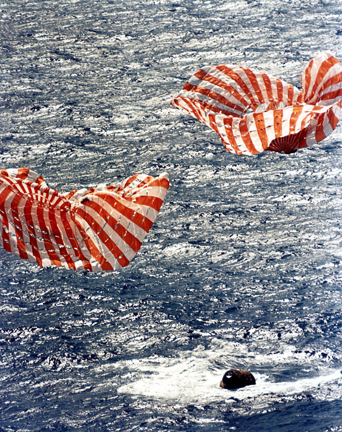
Apollo 14's splashdown in the Pacific on Feb. 9, 1971. (NASA/Ed Hengeveld)
On this day in 1971 Apollo 14 astronauts Alan Shepard, Jr., Stuart Roosa and Edgar Mitchell returned to Earth, splashing down in the Pacific Ocean at 21:05 UT (4:05 p.m. EST). They were recovered by the USS New Orleans, and returned to the U.S. by way of American Samoa. But the three men weren’t the only living creatures to come back from the Moon on Feb. 9, 1971… in fact, human astronauts were in the minority that day.
Al, Stu and Ed shared their lunar voyage with nearly 500 trees.
As Shepard and Mitchell gathered samples near their landing site in a region named Fra Mauro, Apollo 14 pilot and ex-smoke jumper Stuart Roosa orbited above in “Kitty Hawk”, the mission’s Command Module. It may sound like a lonely job, but he was far from alone. Within his personal kit were small containers containing 400-500 seeds, part of a joint NASA/USFS project to examine the effects, if any, of space travel on such organisms.
The seeds were selected from a variety of tree species: redwood, loblolly pine, sycamore, Douglas fir, and sweetgum seeds were all chosen to accompany Roosa on his 34 orbits around the Moon.
A control group of the same seed varieties were kept on Earth for comparison.
Stuart Roosa had worked for the Forest Service in the 1950s before becoming an Air Force test pilot and then eventually an Apollo astronaut. Being charged with the care of the seeds was a particularly symbolic assignment for Roosa, who had once fought wildfires as a smoke jumper.
Even though there was a mishap during the decontamination process after return to Earth, wherein some containers burst open and seeds were inadvertently mixed together, many of the seeds successfully germinated at Forest Service stations in Mississippi and California. The seedlings were eventually sent to locations around the country and around the world to commemorate the success of the Apollo program.
There was even a second generation, called half-moon trees.
A Moon Tree located outside Goddard Space Flight Center. (GSFC)
Many of these “Moon Trees” and their descendants still stand today. In some instances they are marked with a plaque or a sign… in others, no special marking denotes their significance. Those unmarked trees stand as silent reminders of an earlier and perhaps even bolder era of human space flight.
Read more about the Moon Trees on this page by David Williams of NASA’s Goddard Space Flight Center. And if you know of a Moon Tree that is not on Mr. William’s list, please contact him to have it included. Williams has endeavored to locate the whereabouts and status of these trees since 1996, as there had been no systematic records previously kept of them.
“I think when people are aware of the heritage of the trees, they usually take steps to preserve them,” said Williams in recollection of one tree that was nearly knocked down during a building renovation. “But sometimes people aren’t aware. That’s why we want to locate as many as we can soon. We want to have a record that these trees are — or were — a part of these communities, before they’re gone.”
A Progress resupply vehicle seen on approach to the ISS on Jan. 27, 2012. (NASA)
[/caption]
When you’re cruising along in low-Earth orbit, running out of supplies is not an option. Fortunately there are Progress vehicles: Russian spacecraft that carry much-needed supplies and equipment to the astronauts aboard the Space Station.
The photo above, taken by Expedition 30 crew members, shows the unmanned Progress 46 vehicle approaching the ISS on January 27, 2012.
Progress 46 carried 2,050 pounds of propellant, 110 pounds oxygen and air, 926 pounds of water and 2,778 pounds of parts and experiment hardware, for a total of 2.9 tons of food, fuel and equipment for the Expedition 30 crew.
The Progress is similar in appearance and design to Soyuz spacecraft, which serve as human transportation to and from the Space Station, but differs in that the second of the spacecraft’s three sections (as prior to launch) is a refueling module, and the third uppermost section is a cargo module.
In addition to bringing supplies to the ISS, Progress vehicles also serve as – for lack of a better term – “garbage trucks”, undocking from the Station loaded with trash and re-entering the atmosphere, during which time much of the refuse inside gets incinerated.
Progress 46 successfully docked to the Space Station at 7:09 p.m. (EST) on Jan. 27, 2012.
We’ve featured wonderful time-lapse videos taken from the Space Station many times and each one is amazing to watch, but here’s something a little different: by taking photos at the rate of one per second and assembling them into a time-lapse, we can get a sense of what it’s like to orbit the planet at 240 miles up, 17,500 mph… in real time. Absolutely amazing!
Time-lapse photographer Christian Mülhauser braved sub-zero temperatures and frozen camera equipment to capture this stunning aurora footage from Norway during the last week of January 2012.
Powerful solar storms in January made for some impressive auroral displays… thanks to Christian for capturing them on camera!
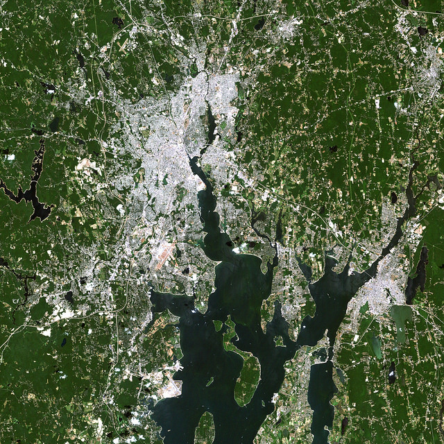
Satellite image of RI and portions of southeastern Massachusetts. Credit: NASA/GSFC/Landsat 7
[/caption]
If you live in or are from the US, you probably know that today is Super Bowl Sunday. Whatever you happen to be doing, be it tailgating in Indianapolis, getting together with friends and family (and plenty of hot wings and nachos) in your living room or just waiting for all the fuss to be over, remember that, high above, NASA Earth-observing satellites are working hard doing what they do best: observing the Earth. Chances are they’ve imaged your home town many times.
Whichever team you’re rooting for, here’s a little bit of space science fun: the folks over at Goddard Space Flight Center in Greenbelt, MD, have shared some Landsat images of the home cities of this year’s big game.
The image above shows the central and northern RI and southeastern Massachusetts area, with Providence and Pawtucket seen as the densely-built central region and Foxborough, MA, where the Patriots’ home stadium is located, is just to the north of the image. This image was acquired by Landsat 7 in July 2002.
(Being of my home state, I admit I’m partial to that particular shot. I was down there somewhere!)
The NYC area seen from satellite. Credit: NASA/GSFC/Landsat 7
If you’re a die-hard Giants fan, you may recognize this area… you may even be in it! It’s a Landsat 7 image of the New York metro area acquired on August 8, 2002. Manhattan is in the center, most easily recognizable from space by the green rectangle of Central Park. New Jersey is on the left side, and Brooklyn on the center-right with Long Island stretching away to the east.
Indianapolis from Landsat 7 satellite. Credit: NASA/GSFC/Landsat 7
If you’re lucky enough to have tickets to the big game, you may be here: it’s a Landsat image of Indianapolis, IN acquired on July 11, 2001. The Colts may not have made it this year but right now the city is definitely “ready for some football!”
Of course, team and town loyalty aside, this gorgeous image from Expedition 30 crew members aboard the ISS shows everyone all in one place on the night of January 29, 2012 – with a nice touch of northern lights thrown in for good measure:
US East Coast on Jan. 29, 2012. (NASA)
Bright lights, big cities… but a small world, when you think about it. And remember, whichever team comes out on top today, tomorrow we’re all winners. (Until next season, of course!)
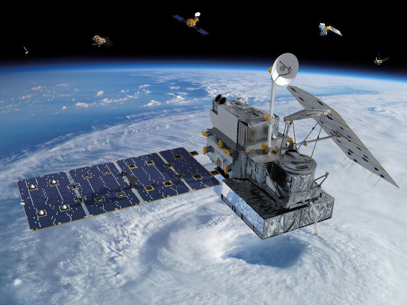
Visualization of the GPM Core Observatory and Partner Satellites. Credit: NASA
[/caption]
An international plan is unfolding that will launch satellites into orbit to study global snowfall precipitation with unprecedented detail. With the upcoming Global Precipitation Measurement (GPM) satellites, for the first time we will know when, where and how much snow falls on Earth, allowing greater understanding of energy cycles and how best to predict extreme weather.
Snow is more than just a pretty winter decoration… it’s also a very important contributor to fresh water supply in many regions around the world, especially those areas that rely on spring runoff from mountains.
The snowmelt from the Sierra Nevadas, for example, accounts for a third of the water supply for California.
But changing climate and recent drought conditions have affected how much snow the mountains receive in winter… and thus how much water is released in the spring. Unfortunately, as of now there’s no reliable way to comprehensively detect and measure falling snow from space… whether in the Sierras or the Andes or the Alps.
Engineers are building and testing the GPM Core Observatory at Goddard Space Flight Center. (NASA/GSFC)
The GPM Core satellite, slated to launch in 2014, will change that.
“The GPM Core, with its ability to detect falling snows, it’s one of the very first times that we’ve put sensors in space to specifically look at falling snow,” said GPM Deputy Project Scientist Gail Skofronick-Jackson in an online video. “We’re at that edge where rain was fifty years ago. We’re still figuring out how to measure snow.”
And why is snow such a difficult subject to study?
“Rain tends to be spherical like drops,” says Skofronick-Jackson. “But if you’ve ever been out in a snowfall and you’ve looked at your shirt, you see the snow comes in all different forms.”
Once GPM scientists calculate all the various types of snowflake shapes, the satellite will be able to detect them from orbit.
“The GPM Core, with its additional frequencies and information on the sensors, is going to be able to provide us for the first time a lot more information about falling snow than we’ve ever done before.”
Knowing where and how much snow and rain falls globally is vital to understanding how weather and climate impact both our environment and Earth’s energy cycles, including effects on agriculture, fresh water availability, and responses to natural disasters.
Snowfall is a missing part of the puzzle, and GPM will fill those pieces in.
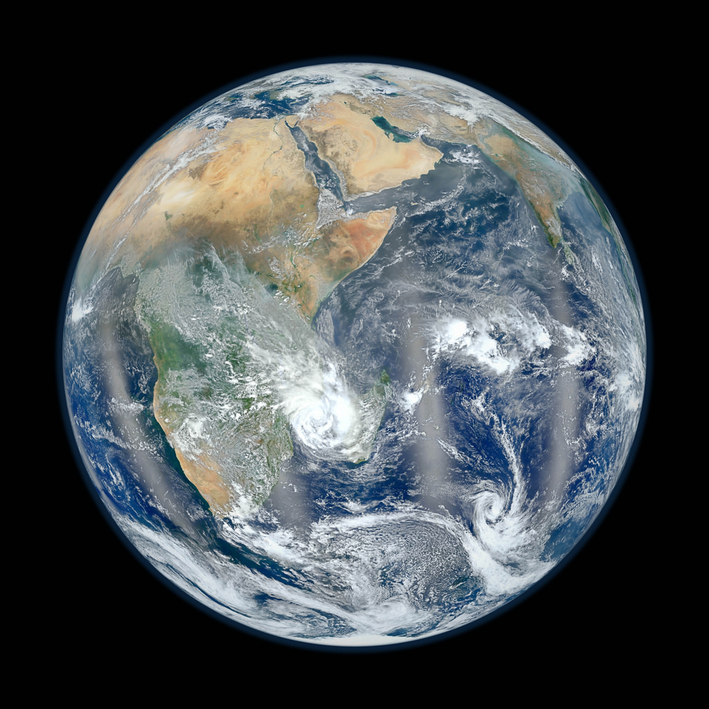
Earth's eastern hemisphere made from Suomi NPP satellite images. (NASA/NOAA)
[/caption]
In response to last week’s incredibly popular “Blue Marble” image, NASA and NOAA have released a companion version, this one showing part of our planet’s eastern hemisphere.
The image is a composite, made from six separate high-resolution scans taken on January 23 by NASA’s recently-renamed Suomi NPP satellite.
Compiled by NASA Goddard scientist Norman Kuring, this image has the perspective of a viewer looking down from 7,918 miles (about 12,742 kilometers) above the Earth’s surface from a viewpoint of 10 degrees South by 45 degrees East. The four vertical lines of ‘haze’ visible in this image shows the reflection of sunlight off the ocean, or ‘glint,’ that VIIRS captured as it orbited the globe. Suomi NPP is the result of a partnership between NASA, NOAA and the Department of Defense.
Last week’s “Blue Marble” image is now one of the most-viewed images of all time on Flickr, receiving nearly 3.2 million views!
NASA launched the National Polar-orbiting Operational Environmental Satellite System Preparatory Project (or NPP) on October 28, 2011 from Vandenberg Air Force Base. On Jan. 24, NPP was renamed Suomi National Polar-orbiting Partnership, or Suomi NPP, in honor of the late Verner E. Suomi. It’s the first satellite designed to collect data to improve short-term weather forecasts and increase understanding of long-term climate change.
Image credit: NASA/NOAA
Added: check out a “zoomified” version of this image on John Williams’ StarryCritters site.