Atlas V Launch of Navy’s Revolutionary MUOS-4 Tactical Comsat Produces Exotic Skyshow

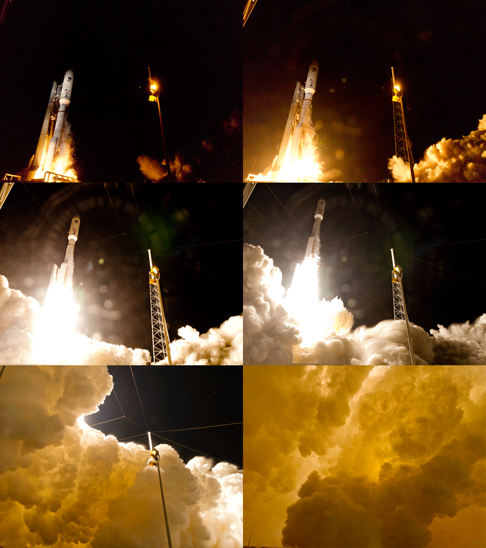
ULA Atlas V rocket successfully launches MUOS-4 for the U.S. Navy on Sept. 2, 2015 from Cape Canaveral Air Force Station, Florida. Credit: ULA

ULA Atlas V rocket successfully launches MUOS-4 for the U.S. Navy on Sept. 2, 2015 from Cape Canaveral Air Force Station, Florida. Credit: ULA
See launch gallery below[/caption]

CAPE CANAVERAL AIR FORCE STATION, FL – Today’s (Sept. 2) stunningly successful launch of the US Navy’s revolutionary MUOS-4 tactical communications satellite atop a mighty Atlas V rocket produced an unexpectedly exotic skyshow beyond compare for lucky spectators all around the Florida Space Coast, as it thundered off a Cape Canaveral launch pad and simultaneously generated house and bone rattling vibrations.

Seasoned and long time launch enthusiasts have rarely if ever never seen anything like this morning’s spectacular predawn launch of the Mobile User Objective System-4 (MUOS-4) satellite for the US Navy at 6:18 a.m. EDT aboard a United Launch Alliance Atlas V rocket from Cape Canaveral Air Force Station, Florida.

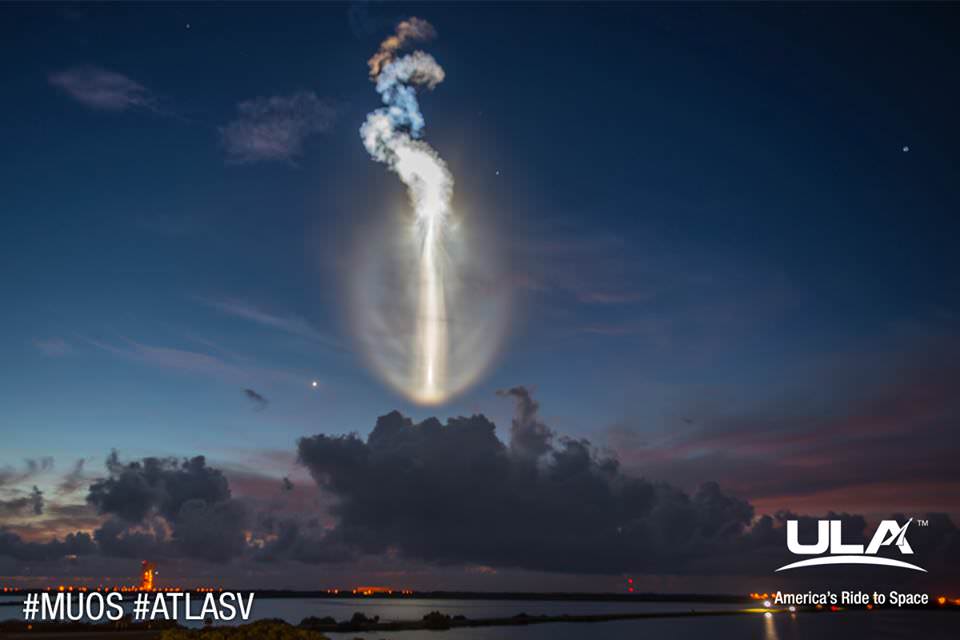
As the rocket arced over eastwards above the Atlantic Ocean the huge vapor trail turned utterly exotic – producing a whitish oval glow that appeared out of nowhere, and looked to me like a moving and living creature as it moved downwards and forwards. Although the rocket appeared to head towards the Earth’s horizon it was actually being propelled to orbit by the most powerful variant of the Atlas V rocket.
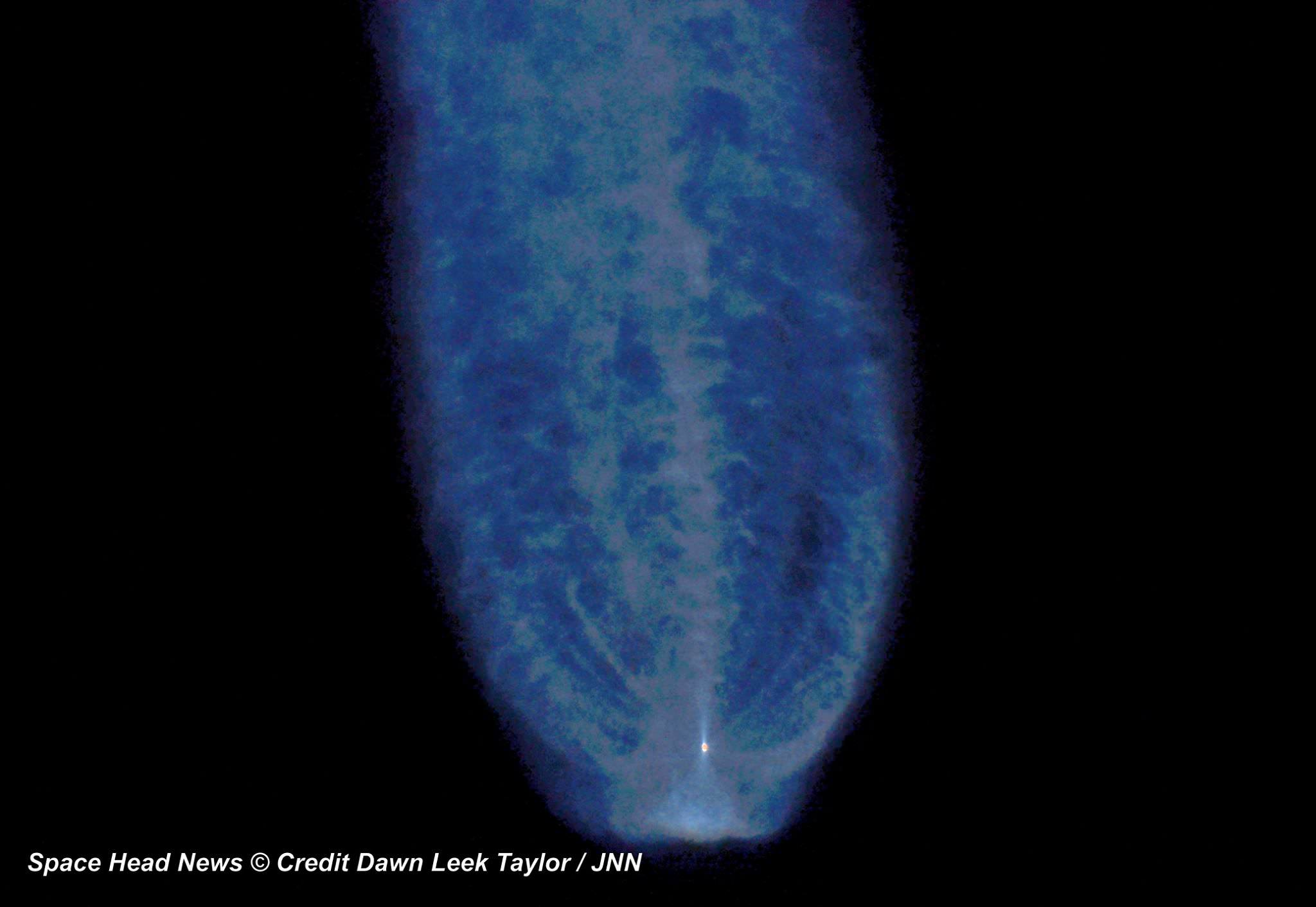
Exotic vapor produced by launch of MUOS-4 communications satellite for the US Navy atop a United Launch Alliance Atlas V rocket from Space launch Complex-41 at Cape Canaveral Air Force Station, FL on Sept. 2, 2015. Credit: Dawn Leek Taylor/Space Head News
Exotic vapor trail produced by launch of MUOS-4 communications satellite for the US Navy atop a United Launch Alliance Atlas V rocket from Space launch Complex-41 at Cape Canaveral Air Force Station, FL on Sept. 2, 2015. Credit: Dawn Leek Taylor/Space Head News

The alien looking trail was fortuitously highlighted by glint from the sun that may have been enhanced by a slight delay of some 19 minutes from the originally planned launch time of 5:59 a.m. EDT as the launch team worked to resolve a technical issue.

Local residents in the Titusville, Fl, area and surroundings told me that their houses and windows shook this morning from the powerful roar and thunderous sound waves pulsing away from the Atlas V rocket. Sleeping children were awoken, close to school time anyway! And another gentleman said he felt it inside the shower with running water – having misunderstood the launch time!

The MUOS-4 launch by United Launch Alliance had also been postponed by 48 hours from Monday morning Aug. 31 due to threatening weather expected from Tropical Storm Erika which most likely would have obliterated today’s uniquely beautiful experience!

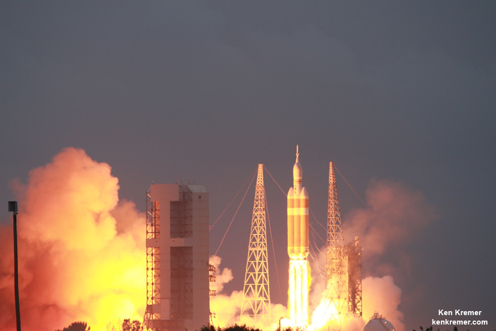
Blastoff of MUOS-4 US Navy communications satellite on United Launch Alliance Atlas V rocket from pad 41 at Cape Canaveral Air Force Station, FL on Sept. 2, 2015. Credit: Ken Kremer/kenkremer.com

The Lockheed Martin-built MUOS-4 satellite was successfully orbited by the Atlas V and is already talking from space to the satellite control team at the Naval Spacecraft Operations Control facility in Naval Base Ventura County, Point Mugu, Calif.

MUOS-4 will enable near-global coverage for a new secure military communications network offering enhanced capabilities for mobile forces.

“Today’s successful launch will enable the MUOS constellation to reach global coverage,” said Jim Sponnick, ULA vice president, Atlas and Delta Programs.

“The Lockheed Martin-built MUOS-4 satellite will deliver voice, data, and video communications capability, similar to a cellular network, to our troops all over the globe.”
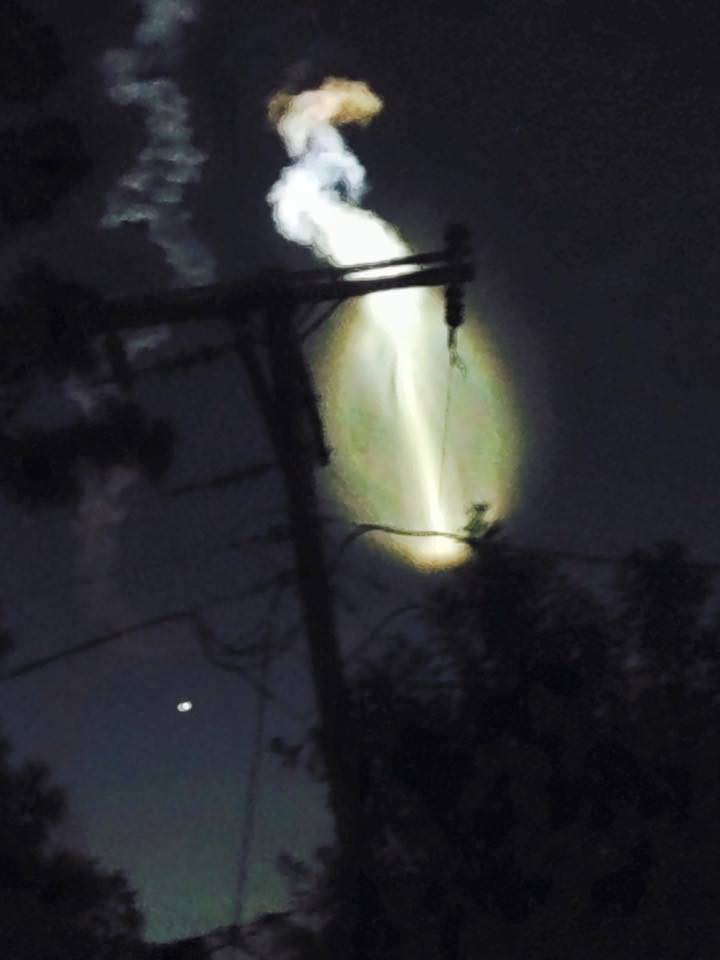
Weird exhaust trail from launch of MUOS-4 communications satellite for the US Navy atop a United Launch Alliance Atlas V rocket from Space launch Complex-41 at Cape Canaveral Air Force Station, FL on Sept. 2, 2015 by Titusville, FL  resident Ashley Crouch. Credit: Ashley Crouch
Weird exhaust trail from launch of MUOS-4 communications satellite for the US Navy atop a United Launch Alliance Atlas V rocket from Space launch Complex-41 at Cape Canaveral Air Force Station, FL on Sept. 2, 2015 by Titusville, FL resident Ashley Crouch. Credit: Ashley Crouch

MUOS is a next-generation narrowband tactical satellite communications system designed to significantly improve ground communications for U.S. forces on the move.

This is the fourth satellite in the MUOS series and will provide military users up to 16 times more communications capability over existing systems, including simultaneous voice, video and data, leveraging 3G mobile communications technology.

With MUOS-4 in orbit the system’s initial constellation is completed. It provides the MUOS network with near-global coverage. Communications coverage for military forces now extends further toward the North and South poles than ever before, according to Lockheed Martin officials.
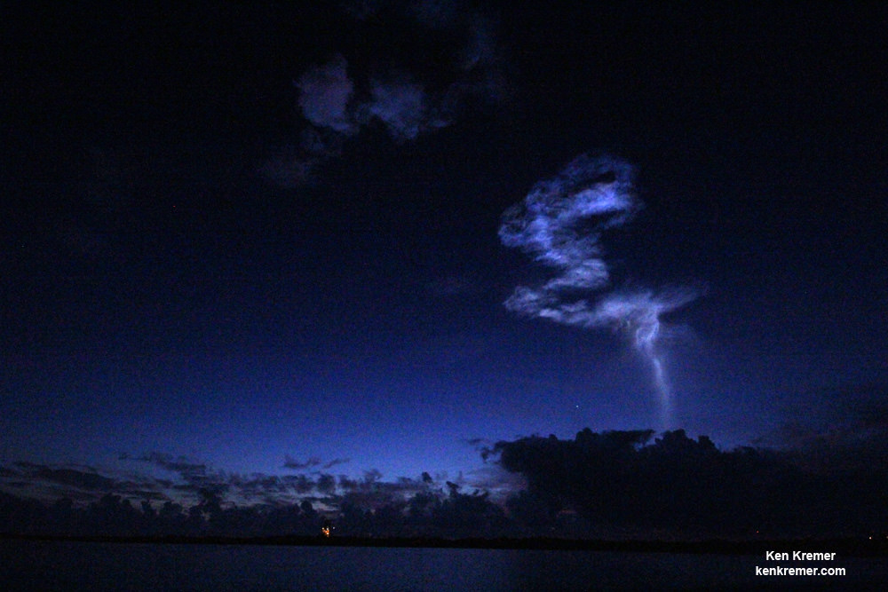
Exotic vapor produced by launch of MUOS-4 communications satellite for the US Navy atop a United Launch Alliance Atlas V rocket from Space launch Complex-41 at Cape Canaveral Air Force Station, FL on Sept. 2, 2015. Credit: Ken Kremer/kenkremer.com
Exotic vapor trail produced by launch of MUOS-4 communications satellite for the US Navy atop a United Launch Alliance Atlas V rocket from Space launch Complex-41 at Cape Canaveral Air Force Station, FL on Sept. 2, 2015. Credit: Ken Kremer/kenkremer.com

The unmanned Atlas V expendable rocket launched in its mightiest configuration known as the Atlas V 551 with five solid rocket boosters augmenting the first stage.

The 206 foot-tall rocket features a 5-meter diameter payload fairing, five Aerojet Rocketdyne first stage strap on solid rocket motors and a single engine Centaur upper stage powered by the Aerojet Rocketdyne RL10C-1 engine.

The first stage is powered by the Russian-built dual nozzle RD AMROSS RD-180 engine. Combined with the five solid rocket motors, the Atlas V first stage generates over 2.5 million pounds of liftoff thrust.

The RD-180 burns RP-1 (Rocket Propellant-1 or highly purified kerosene) and liquid oxygen and delivers 860,200 lb of thrust at sea level.

And the rocket needed all that thrust because the huge MUOS-4 was among the heftiest payloads ever lofted by an Atlas V booster, weighing in at some 15,000 pounds.
MUOS-4, the next satellite scheduled to join the U.S. Navy’s Mobile User Objective System (MUOS) secure communications network, launched on Sept 2, 2015 from Cape Canaveral Air Force Station, Florida and is responding normally to ground control.  Credit: Lockheed Martin
MUOS-4, the next satellite scheduled to join the U.S. Navy’s Mobile User Objective System (MUOS) secure communications network, launched on Sept 2, 2015 from Cape Canaveral Air Force Station, Florida and is responding normally to ground control. Credit: Lockheed Martin

Ken is onsite for launch coverage from Cape Canaveral Air Force Station and the Kennedy Space Center.

Stay tuned here for Ken’s continuing Earth and planetary science and human spaceflight news.

Ken Kremer

………….

Learn more about MUOS-4 US Navy launch, Orion, SLS, SpaceX, Boeing, ULA, Space Taxis, Mars rovers, Orbital ATK, Antares, NASA missions and more at Ken’s upcoming outreach events:

Sep 2/3: “MUOS-4 launch, Orion, Commercial crew, Curiosity explores Mars, Antares and more,” Kennedy Space Center Quality Inn, Titusville, FL, evenings
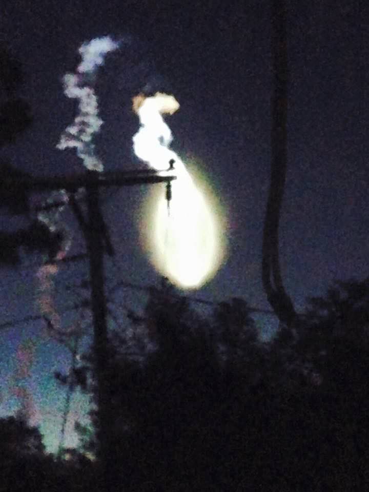
Weird exhaust trail from launch of MUOS-4 communications satellite for the US Navy atop a United Launch Alliance Atlas V rocket from Space launch Complex-41 at Cape Canaveral Air Force Station, FL on Sept. 2, 2015 by Titusville, FL  resident Ashley Crouch. Credit: Ashley Crouch
Weird exhaust trail from launch of MUOS-4 communications satellite for the US Navy atop a United Launch Alliance Atlas V rocket from Space launch Complex-41 at Cape Canaveral Air Force Station, FL on Sept. 2, 2015 by Titusville, FL resident Ashley Crouch. Credit: Ashley Crouch
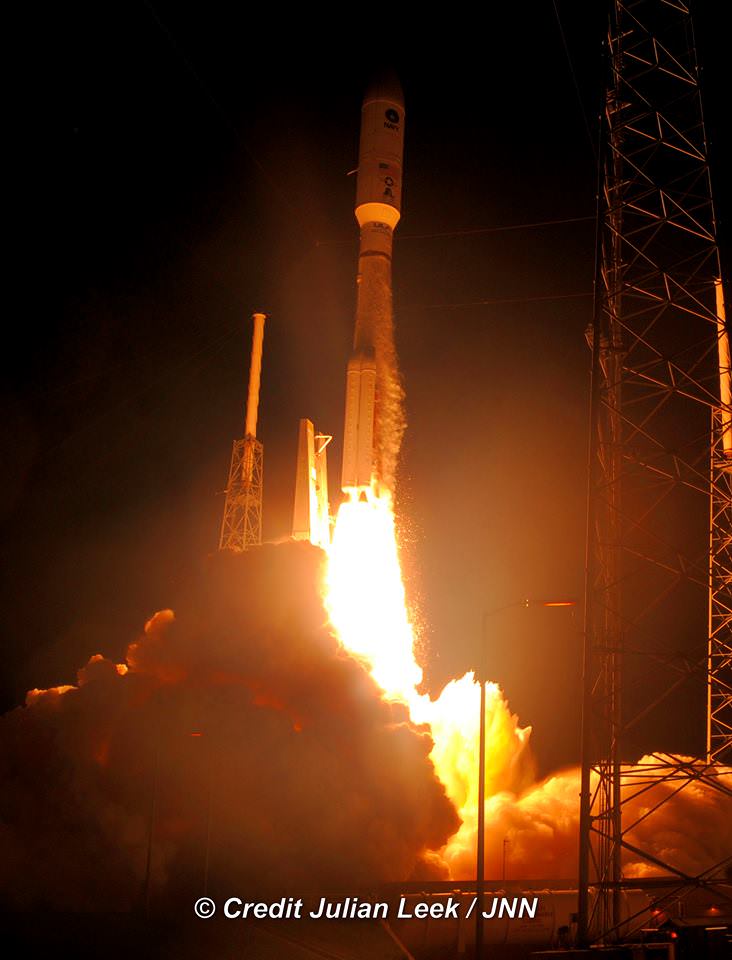
Liftoff of MUOS-4 comsat for US Navy on a United Launch Alliance Atlas V rocket from Space launch Complex-41 at Cape Canaveral Air Force Station, FL on Sept. 2, 2015. Credit: Julian Leek/Space Head News
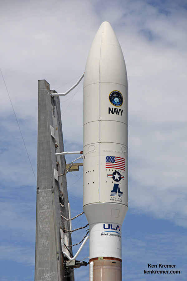
MUOS-4 US Navy communications satellite and Atlas V rocket at pad 41 at Cape Canaveral Air Force Station, FL for launch on Sept. 2, 2015 at 5:59 a.m. EDT. Credit: Ken Kremer/kenkremer.com

Tropical Storm Erika Delayed Blastoff for US Navy set for Sept. 2 on Most Powerful Atlas V Rocket: Watch Live

MUOS-4 US Navy communications satellite and Atlas V rocket at pad 41 at Cape Canaveral Air Force Station, FL for launch on Sept. 2, 2015 at 5:59 a.m. EDT. Credit: Ken Kremer/kenkremer.com

CAPE CANAVERAL AIR FORCE STATION, FL – Blastoff of an advanced communications satellite for the US Navy is set for early Wednesday morning, Sept. 2, using the most powerful variant of the United Launch Alliance (ULA) Atlas V rocket – following a 48 hour postponement due to terrible weather expected from Tropical Storm Erika, which pounded islands in the Caribbean causing destruction and over 20 deaths.

The threat of strong winds and heavy rains forced Florida Gov. Rick Scott to declare a state of emergency in every county in Florida last Friday that was still in effect as rains doused central Florida on Monday.

ULA decided against rolling the Atlas V rocket out to the seaside pad on Saturday in support of the then planned launch of the Multi-User Objective System satellite on Aug. 31.

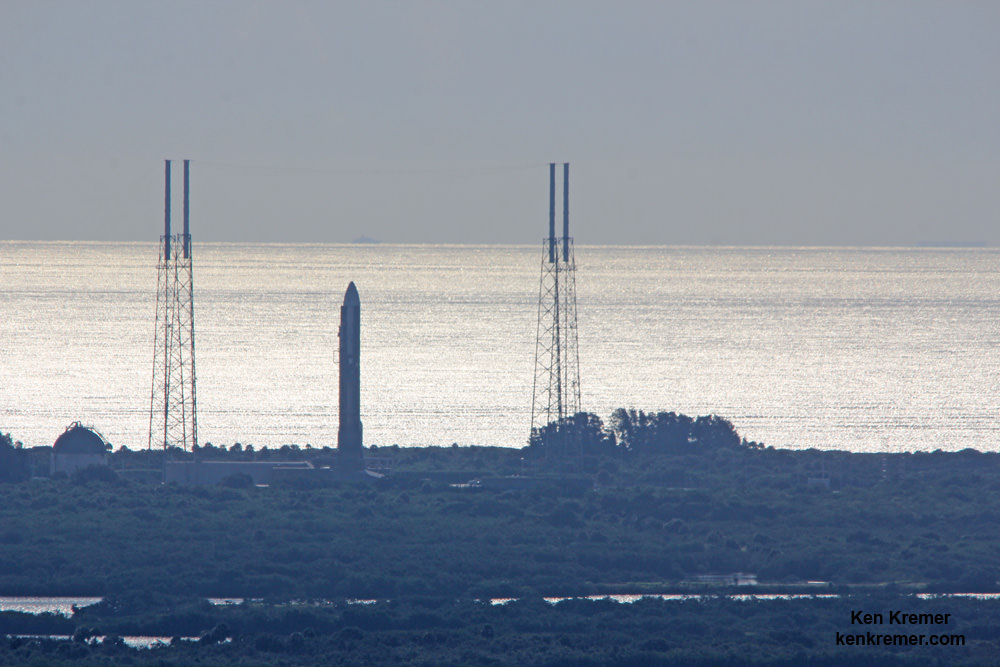
Liftoff of the Multi-User Objective System-4 (MUOS-4) satellite for the US Navy is now slated for 5:59 a.m. EDT from Space Launch Complex-41 at Cape Canaveral Air Force Station in Florida, and will be broadcast live.

The launch window extends for 44 minutes from 5:59-6:43 a.m. EDT and the weather outlook is now promising.

US Air Force weather forecasters currently predict a 70% chance of favorable weather conditions for “GO” at launch time on Wednesday morning.

The primary concern is for cumulus clouds.

The unmanned Atlas V expendable rocket will launch in its mightiest configuration known as the Atlas V 551 with five solid rocket boosters augmenting the first stage.
Therefore the predawn liftoff is expected to be absolutely spectacular, resonating with a thunderous roar rising on a huge smoke trail that will light up the darkened skies all around the Florida Space Coast for spectators here and far beyond.

You can watch the launch on your laptop or smart phone since it will be carried live on a ULA webcast: http://www.ulalaunch.com

The ULA webcast starts about 20 minutes before launch.

The launch time moves up 4 minutes in the event of a 24 hour delay. The weather prognosis stands at 70 percent “GO”.

MUOS-4 US Navy communications satellite stowed inside huge 5 meter diameter payload fairing atop Atlas V rocket at pad 41 at Cape Canaveral Air Force Station, FL set for launch on Sept. 2, 2015. EDT. Credit: Ken Kremer/kenkremer.com

MUOS is a next-generation narrowband tactical satellite communications system designed to significantly improve ground communications for U.S. forces on the move.

This is the fourth and last satellite in the MUOS series and will provide military users 10 times more communications capability over existing systems, including simultaneous voice, video and data, leveraging 3G mobile communications technology.

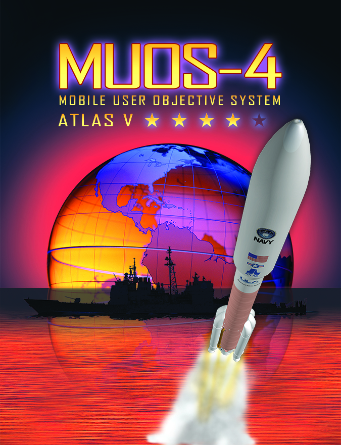
MUOS-4 satellite artwork.  Credit: US Navy/ULA
MUOS-4 satellite artwork. Credit: US Navy/ULA

MUOS-3 launched earlier this year.

The launch countdown will begin at 11:09 p.m. EDT on Tuesday night, Sept. 1, followed by fueling of the Atlas V rocket.

Ken is onsite for launch coverage from Cape Canaveral Air Force Station and the Kennedy Space Center.

Stay tuned here for Ken’s continuing Earth and planetary science and human spaceflight news.

Ken Kremer

United Launch Alliance Atlas V rocket with MUOS-4 US Navy communications satellite poised at pad 41 at Cape Canaveral Air Force Station, FL, set for launch on Sept. 2, 2015. EDT. View from atop NASA’s SLS mobile launcher at the Kenned Space Center. Credit: Ken Kremer/kenkremer.com

………….

Learn more about MUOS-4 US Navy launch, Orion, SLS, SpaceX, Boeing, ULA, Space Taxis, Mars rovers, Orbital ATK, Antares, NASA missions and more at Ken’s upcoming outreach events:

Sep 1 – Sep 2: “MUOS-4 launch, Orion, Commercial crew, Curiosity explores Mars, Antares and more,” Kennedy Space Center Quality Inn, Titusville, FL, evenings

NASA Tests Orion’s Fate During Parachute Failure Scenario

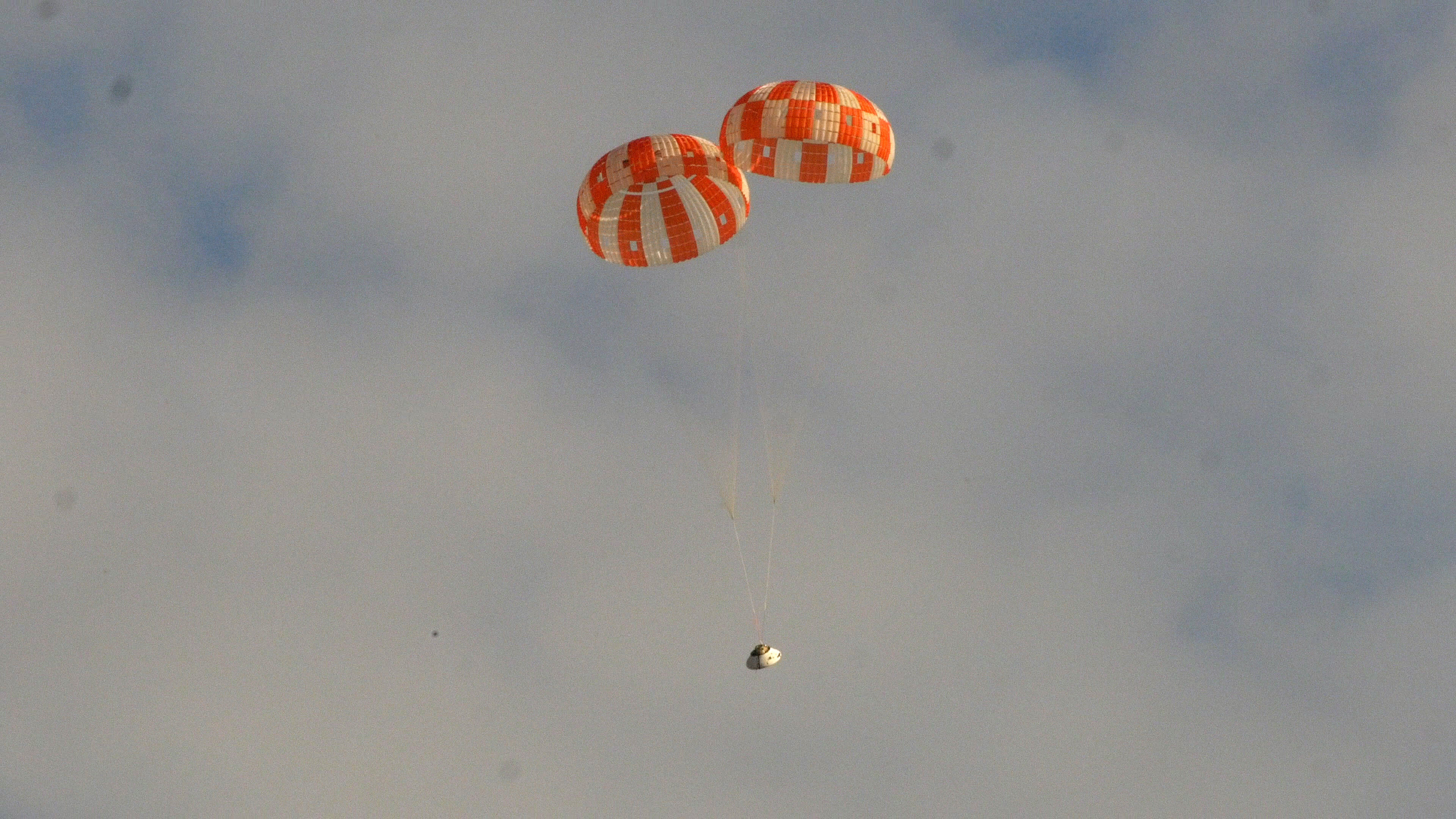
A test version of NASA's Orion spacecraft successfully landed under two main parachutes in the Arizona desert Aug. 26, 2015 at the U.S. Army's Yuma Proving Ground. Credit: NASA

What would happen to the astronaut crews aboard NASA’s Orion deep space capsule in the event of parachute failures in the final moments before splashdown upon returning from weeks to years long forays to the Moon, Asteroids or Mars?

NASA teams are evaluating Orion’s fate under multiple scenarios in case certain of the ships various parachute systems suffer partial deployment failures after the blistering high speed reentry into the Earth’s atmosphere.

Orion is nominally outfitted with multiple different parachute systems including two drogue chutes and three main chutes that are essential for stabilizing and slowing the crewed spacecraft for safely landing in the Pacific Ocean upon concluding a NASA ‘Journey to Mars’ mission.”

This week engineers from NASA and prime contractor Lockheed Martin ran a dramatic and successful six mile high altitude drop test in the skies over the Arizona desert, in the instance where one of the parachutes in each of Orion’s drogue and main systems was intentionally set to fail.

“We test Orion’s parachutes to the extremes to ensure we have a safe system for bringing crews back to Earth on future flights, even if something goes wrong,” says CJ Johnson, project manager for Orion’s parachute system, in a statement.

“Orion’s parachute performance is difficult to model with computers, so putting them to the test in the air helps us better evaluate and predict how the system works.”

Although Orion hits the atmosphere at over 24,000 mph after returning from deep space, it slows significantly after atmospheric reentry.

By the time the first parachutes normally deploy, the crew module has decelerated to some 300 mph. Their job is to slow the craft down to about 20 mph by the time of ocean splashdown mere minutes later.

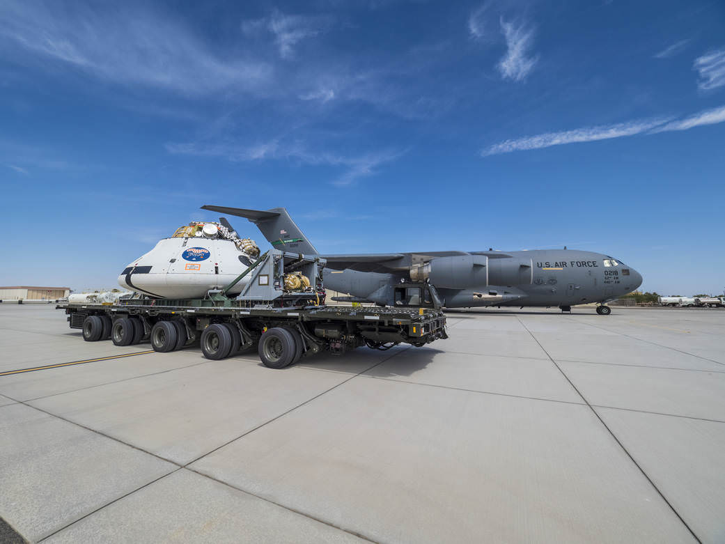
On Aug. 26, NASA conducted a 35,000 foot high drop test out of the cargo bay of a C-17 aircraft using an engineering test version of the Orion capsule over the U.S. Army Yuma Proving Ground in Yuma, Arizona.

“The engineering model has a mass similar to that of the Orion capsule being developed for deep space missions, and similar interfaces with its parachute system,” say officials.

“Engineers purposefully simulated a failure scenario in which one of the two drogue parachutes, used to slow and stabilize Orion at high altitude, and one of its three main parachutes, used to slow the crew module to landing speed, did not deploy.”

Here’s a video detailing the entire drop test sequence of events from preflight preparations to the parachute landing.

The high-risk Aug. 26 experiment was NASA’s penultimate drop test in this engineering evaluations series. A new series of tests in 2016 will serve to qualify the parachute system for crewed flights.

Engineers prepare to test the parachute system for NASA’s Orion spacecraft at the U.S. Army Yuma Proving Ground in Yuma, Arizona on Aug. 26, 2015 by loading a test version on a C-17 aircraft. Credit: NASA

Orion’s inaugural mission dubbed Exploration Flight Test-1 (EFT) was successfully launched on a flawless flight on Dec. 5, 2014 atop a United Launch Alliance Delta IV Heavy rocket Space Launch Complex 37 (SLC-37) at Cape Canaveral Air Force Station in Florida.

The parachutes operated flawlessly during the Orion EFT-1 mission.

NASA’s first Orion spacecraft blasts off at 7:05 a.m. atop United Launch Alliance Delta 4 Heavy Booster at Space Launch Complex 37 (SLC-37) at Cape Canaveral Air Force Station in Florida on Dec. 5, 2014.   Credit: Ken Kremer - kenkremer.com
NASA’s first Orion spacecraft blasts off at 7:05 a.m. atop United Launch Alliance Delta 4 Heavy Booster at Space Launch Complex 37 (SLC-37) at Cape Canaveral Air Force Station in Florida on Dec. 5, 2014. Credit: Ken Kremer – kenkremer.com

Orion’s next launch is set for the uncrewed test flight called Exploration Mission-1 (EM-1). It will blast off on the inaugural flight of NASA’s SLS heavy lift monster rocket concurrently under development – from Launch Complex 39-B at the Kennedy Space Center.

The maiden SLS test flight is targeted for no later than November 2018 and will be configured in its initial 70-metric-ton (77-ton) version with a liftoff thrust of 8.4 million pounds. It will boost an unmanned Orion on an approximately three week long test flight beyond the Moon and back.

Toward that goal, NASA is also currently testing the RS-25 first stage engines that will power SLS – as outlined in my recent story here.

NASA plans to gradually upgrade the SLS to achieve an unprecedented lift capability of 130 metric tons (143 tons), enabling the more distant missions even farther into our solar system.

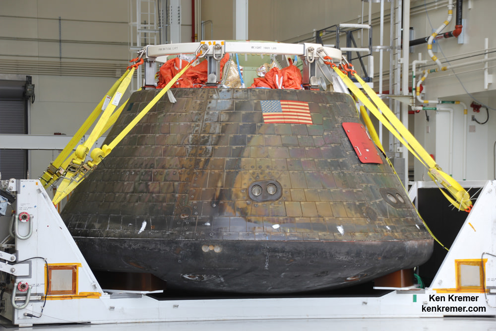
Homecoming view of NASA’s first Orion spacecraft after returning to NASA’s Kennedy Space Center in Florida on Dec. 19, 2014 after successful blastoff on Dec. 5, 2014.  Credit: Ken Kremer - kenkremer.com
Parachutes are stowed atop Orion
Homecoming view of NASA’s first Orion spacecraft after returning to NASA’s Kennedy Space Center in Florida on Dec. 19, 2014 after successful blastoff on Dec. 5, 2014. Credit: Ken Kremer – kenkremer.com

Stay tuned here for Ken’s continuing Earth and Planetary science and human spaceflight news.

Ken Kremer

………….

Learn more about MUOS-4 USAF launch, Orion, SLS, SpaceX, Boeing, ULA, Space Taxis, Mars rovers, Orbital ATK, Antares, NASA missions and more at Ken’s upcoming outreach events:

Aug 31- Sep 2: “MUOS-4 launch, Orion, Commercial crew, Curiosity explores Mars, Antares and more,” Kennedy Space Center Quality Inn, Titusville, FL, evenings

Orbital ATK on the Rebound With Antares Return to Flight in 2016

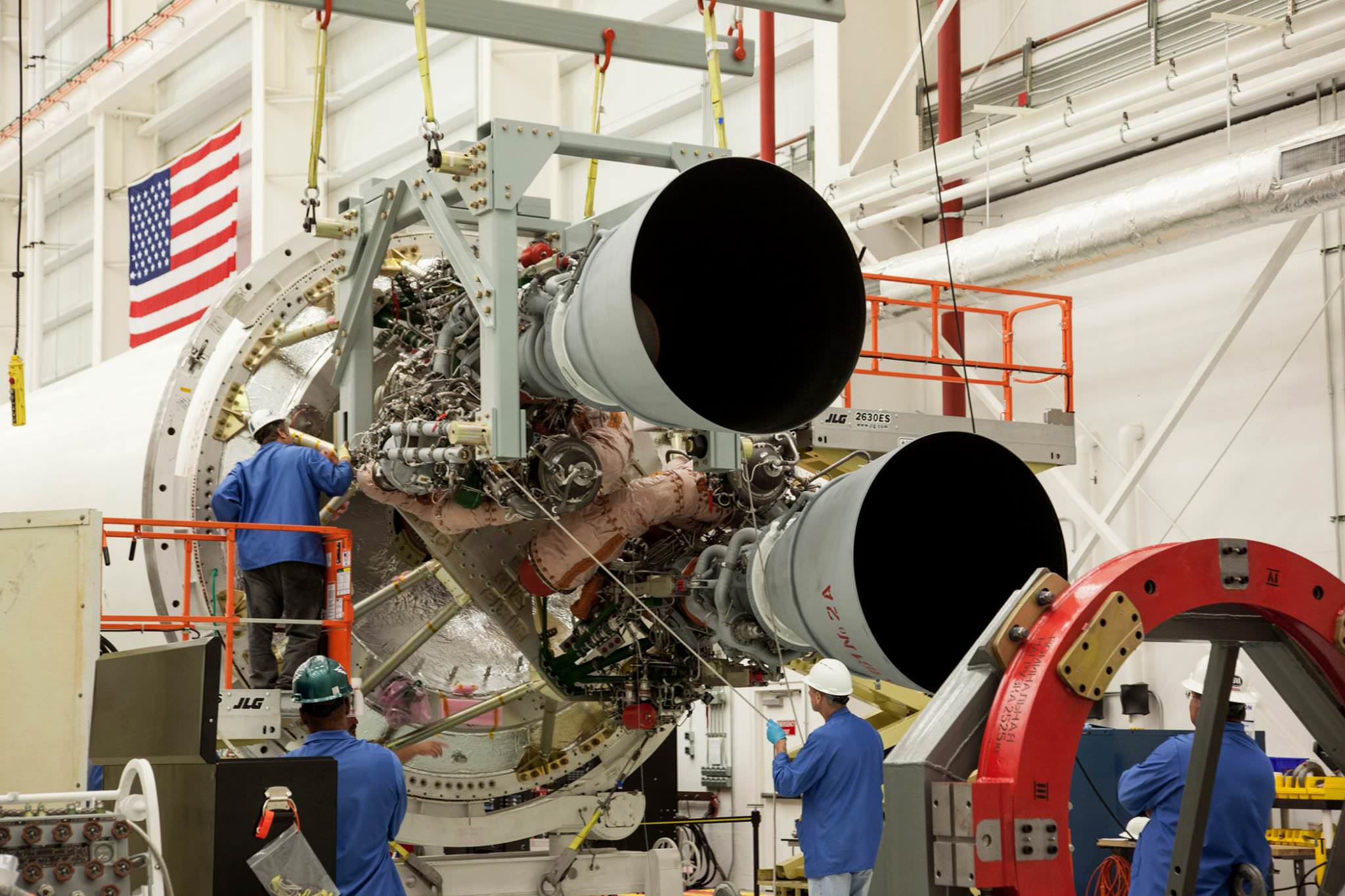
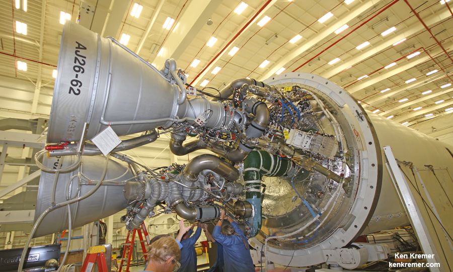
Two RD-181 integrated with the Orbital ATK Antares first stage air frame at the Wallops Island, Virginia Horizontal Integration Facility (HIF). Return to flight launch is expected sometime during Spring 2016. Credit: NASA/ Terry Zaperach

Orbital ATK is on the rebound with return to flight of their Antares rocket slated in early 2016 following the catastrophic launch failure that doomed the last Antares in October 2014 on a resupply mission for NASA to the International Space Station (ISS).

Engineers are making “excellent progress” assembling a modified version of Antares that is currently on track to blast off as soon as March 2016 with the company’s Cygnus resupply ship and resume critical deliveries of research experiments and life sustaining provisions to the multinational crews serving aboard the orbiting outpost.

“We are on track for the next Antares launch in early 2016,” said David Thompson, President and Chief Executive Officer of Orbital ATK in a progress update.

Resuming Antares launches is a key part of the company’s multipronged effort to fulfil their delivery commitments to NASA under the Commercial Resupply Services (CRS) contract.

“The focus all along has been to do everything we can to fulfill our commitments to delivering cargo to the space station for NASA,” Thompson stated.

“After the Antares launch failure last October … our team has been sharply focused on fulfilling that commitment.”

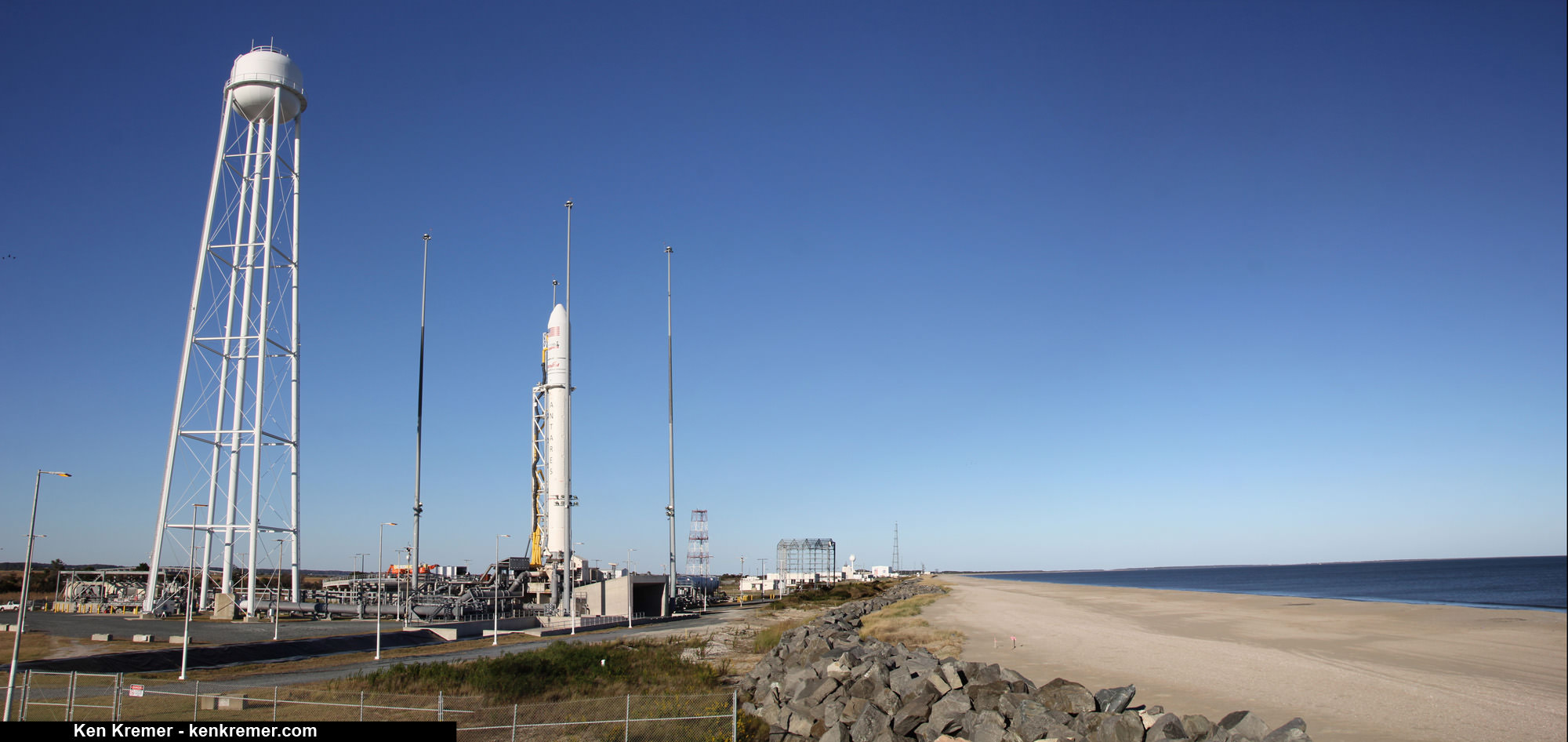
Pre-launch seaside panorama of Orbital Sciences Corporation Antares rocket at the NASA's Wallops Flight Facility launch pad on Oct 26 - 2 days before the ??Orb-3? launch failure on Oct 28, 2014.  Credit: Ken Kremer - kenkremer.com
Pre-launch seaside panorama of Orbital Sciences Corporation Antares rocket at the NASA’s Wallops Flight Facility launch pad on Oct 26 – 2 days before the Orb-3 launch failure on Oct 28, 2014. Credit: Ken Kremer – kenkremer.com

The key milestone was to successfully re-engine Antares with a new type of first stage engine that completely eliminates use of the original AJ26 engines that were refurbished 40 year leftovers – the NK-33 from Russia’s abandoned manned moon landing program.

After the launch failure, Orbital managers decided to ditch the trouble plagued AJ-26 and “re-engineered” the vehicle with the new RD-181 Russian-built engines that were derived from the RD-191.

Soviet era NK-33 engines refurbished as the AJ26 exactly like pictured here probably caused Antares’ rocket failure on Oct. 28, 2014. Orbital Sciences technicians at work on two AJ26 first stage engines at the base of an Antares rocket during exclusive visit by Ken Kremer/Universe Today at NASA Wallaps. These engines powered the successful Antares liftoff on Jan. 9, 2014 at NASA Wallops, Virginia bound for the ISS. Credit: Ken Kremer – kenkremer.com

Orbital ATK holds a Commercial Resupply Services (CRS) contract from NASA worth $1.9 Billion to deliver 20,000 kilograms of research experiments, crew provisions, spare parts and hardware spread out over eight Cygnus cargo delivery flights to the ISS.

NASA has recently supplemented the CRS contract with three additional Cygnus resupply deliveries in 2017 and 2018.

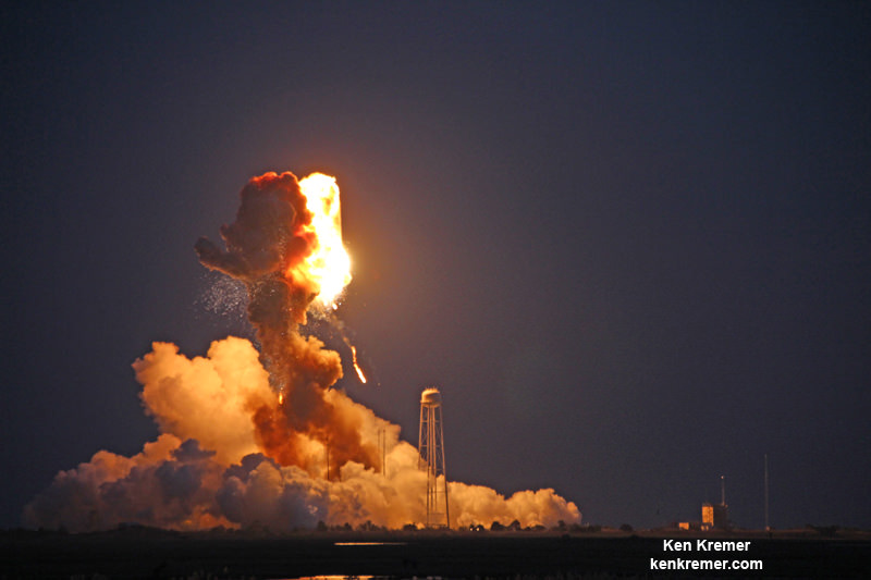
However, the Cygnus missions were put on hold when the third operational Antares/Cygnus flight was destroyed in a raging inferno about 15 seconds after liftoff on the Orb-3 mission from launch pad 0A at NASA’s Wallops Flight Facility on Virginia’s eastern shore.

Until Antares flights can safely resume, Orbital ATK has contracted with rocket maker United Launch Alliance (ULA) to launch a Cygnus cargo freighter atop an Atlas V rocket for the first time, in early December – as I reported here.

The Antares rocket is being upgraded with the new RD-181 main engines powering the modified first stage core structure that replace the troublesome AJ26 engines whose failure caused the Antares Orb-3 launch explosion on Oct. 28, 2014.

Orbital Sciences Antares rocket explodes moments after blastoff from NASA’s Wallops Flight Facility, VA, on Oct. 28, 2014, at 6:22 p.m. Credit: Ken Kremer – kenkremer.com

“We are making excellent progress in resuming our cargo delivery service to the International Space Station for NASA under the Commercial Resupply Services (CRS) contract,” said company officials.

Orbital ATK engineering teams have been working diligently on “integrating and testing the new RD-181 main engines.”

After engineers finished acceptance testing and certification of the RD-181, the first dual engine set was shipped to Orbital’s Wallops Island integration facility. They arrived in mid-July. A second set is due to arrive in the fall.

“The RD-181 engine provides extra thrust and higher specific impulse, significantly increasing the payload capacity of the Antares rocket. This state-of-the-art propulsion system is a direct adaptation of the RD-191 engine, which completed an extensive qualification and certification program in 2013, accumulating more than 37,000 seconds of total run time,” said Scott Lehr, President of Orbital ATK’s Flight Systems Group, in a statement.

Engineers and technicians have now “integrated the two RD-181 engines with a newly designed and built thrust frame adapter and modified first stage airframe.”

Then they will add new propellant feed lines and first stage avionics systems.

Then comes the moment of truth. A “hot fire” test on the launch pad will be conducted by either the end of 2015 or early 2016 “to verify the vehicle’s operational performance and compatibility of the MARS launch complex.”

“Significant progress has been made in the manufacture and test of the modified hardware components, avionics and software needed to support the new engines,” said Mike Pinkston, Vice President and General Manager of Orbital ATK’s Antares Program.

“We are solidly on track to resume flying Antares in 2016.”

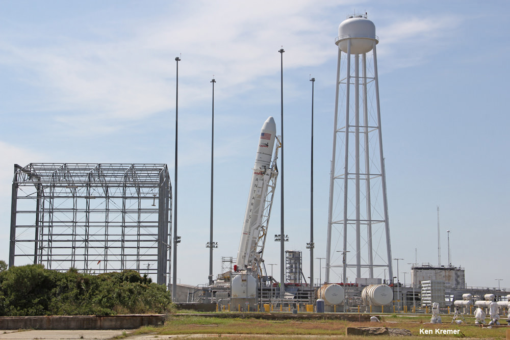
Antares rocket raised at NASA Wallops launch pad 0A bound for the ISS on Sept 18, 2013. Credit: Ken Kremer (kenkremer.com)

Simultaneously, teams have been working hard to repair the Wallops launch pad which was damaged when the doomed Antares plummeted back to Earth and exploded in a hellish inferno witnessed by thousands of spectators and media including myself.

Repairs are expected to be completed by early 2016 to support a launch tentatively planned for as soon as March 2016.

SpaceX, NASA’s other commercial cargo company under contract to ship supplies to the ISS also suffered a launch failure of with their Falcon 9/Dragon cargo delivery rocket on June 28, 2015.

NASA is working with both forms to restart the critical ISS resupply train as soon as can safely be accomplished.

Be sure to read Ken’s earlier eyewitness reports about last October’s Antares failure at NASA Wallops and ongoing reporting about Orbital ATK’s recovery efforts – all here at Universe Today.

Stay tuned here for Ken’s continuing Earth and Planetary science and human spaceflight news.

Ken Kremer

………….

Learn more about Orbital ATK, SpaceX, Boeing, ULA, Space Taxis, Mars rovers, Orion, SLS, Antares, NASA missions and more at Ken’s upcoming outreach events:

Aug 29-31: “MUOS-4 launch, Orion, Commercial crew, Curiosity explores Mars, Antares and more,” Kennedy Space Center Quality Inn, Titusville, FL, evenings
‘One Direction’ Heads to Space in new NASA Themed Music Video – ‘Drag Me Down’

‘One Direction’ band mates don spacesuits to board NASA’s Orion deep space crew capsule. Credit: One Direction/NASA

When it comes to space exploration it’s resoundingly clear that rock band ‘One Direction’ is headed in the right direction – To Infinity and Beyond! – with the release of their new NASA themed music video ‘Drag Me Down.’

The new single – ‘Drag Me Down’ – by the world famous boy band is out now and out of this world!

Just click on the Vevo video above and enjoy their musical tour through space exploration themed videos filmed on location at NASA facilities, including the Johnson Space Center – home to astronauts training to explore ‘Where No One Has Gone Before.’

Over 18,100,000 views so far!! Millions of eyeballs exposed to NASA activities like never before!

As you’ll see in the video (published on Aug. 20) the quartet got a first hand look at a host of NASA’s cutting edge technology and hardware like NASA’s Orion deep space crew capsule that’s destined to propel our astronauts back to deep space and explore wondrous destinations including the Moon, asteroids and the Red Planet, as part of the agency’s ‘Journey to Mars’ initiative.

Motivating our young people to study and excel in math, science, engineering, technology and the arts is what it’s all about to inspire the next generation of explorers and advance all humanity to fulfilling and prosperous lives.

“#DragMeDownMusicVideo @space_station Gravity can’t drag me down! Great to see @NASA inspire our next gen #YearInSpace,” tweeted NASA astronaut Scott Kelly currently working aboard the International Space Station.

Lets join “One Direction’s” space tour.

So the guys donned NASA’s spacesuits as they began ‘training’ to fly aboard NASA’s Orion spaceship.

One Direction crew in spacesuits

Orion flew its first uncrewed mission on the EFT-1 flight in December 2014, launching aboard a United Launch Alliance Delta IV Heavy rocket.

Harry, Niall, Louis and Liam all got suited up to check out and sit inside an Orion trainer. Next you’ll see them ‘blast off’ for space atop the Delta IV rocket from the Florida Space Coast in their music video.

tumblr_inline_ntg5w4NNr81tzhl5u_500

But first they rollick with the astronauts T-38 training jets which are used by real-life astronauts to practice spacecraft operations at supersonic speeds up to Mach 1.6 and experience blistering accelerations of more than seven Gs!

tumblr_inline_ntg4daeKad1tzhl5u_500

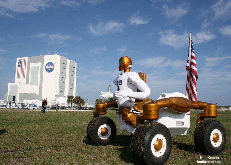
Here we join Louis to rove around Johnson Space Center in NASA’s Space Exploration Vehicle that will one day be used for awe-inspiring interplanetary journey’s to the surface of alien bodies like the moon, near-Earth asteroids and Mars!

Even though Louis is roving around Johnson Space Center in our Space Exploration Vehicle, its intended destination is quite different. The SEV will be used for in-space missions and for surface explorations of planetary bodies, including near-Earth asteroids and Mars!

Wouldn’t you like to join Louis!

Meanwhile Harry got to hang out with Robonaut at the Johnson Space Center during the filming of the music video.

tumblr_inline_ntg3q7Xlt51tzhl5u_500

Simultaneously the Robonauts twin brother, Robonaut 2, is hanging out in space right now with other humans. Robonaut 2 is working side-by-side with NASA astronauts Scott Kelly and Kjell Lindgren and the rest of the six man crew floating aboard the International Space Station and soaring some 250 miles (400 kilometers) overhead.

“Going where the risks are too great for people, robots will make it so we never get ‘dragged down’!” says NASA.

“Currently living in space, @StationCDRKelly is 1 of 6 people that literally cannot be dragged down. #DragMeDown,” NASA tweeted.

The twin brother of the R2 Robonaut launched to the ISS on Space Shuttle Discovery on the STS-133 mission, its 39th and final flight to space. Credit: Ken Kremer/kenkremer.com

And here’s Niall experiencing reduced gravity in the Partial Gravity Simulator & Space Station Mockup Bike. This simulator is where astronauts learn how to work effectively in the partial gravity of space and on the surface of other worlds

tumblr_inline_ntg42dFJkp1tzhl5u_500

I’ve been a fan of ‘One Direction’ and now nothing will ‘hold me back’ following #DragMeDown.

And don’t forget that you can watch Commander Scott Kelly and his five international crew mates on a regular basis as they soar overhead. Just click on NASA’s Spot the Station link and plug in your location.

And make sure you sign up to ‘Send Your Name to Mars’ on InSight – NASA’s next Mars Lander. The deadline is Sept 8 sign up details in my story here.

Orion’s inaugural mission dubbed Exploration Flight Test-1 (EFT) was successfully launched on a flawless flight on Dec. 5, 2014 atop a United Launch Alliance Delta IV Heavy rocket Space Launch Complex 37 (SLC-37) at Cape Canaveral Air Force Station in Florida.

Here’s what the real Orion EFT-1 looked like after the mission was successfully completed and it was recovered from splashdown in the Pacific Ocean.

Homecoming view of NASA’s first Orion spacecraft after returning to NASA’s Kennedy Space Center in Florida on Dec. 19, 2014 after successful blastoff on Dec. 5, 2014.  Credit: Ken Kremer - kenkremer.com
Homecoming view of NASA’s first Orion spacecraft after returning to NASA’s Kennedy Space Center in Florida on Dec. 19, 2014 after successful blastoff on Dec. 5, 2014. Credit: Ken Kremer – kenkremer.com

Right now NASA is building the next Orion.

If you desire to be aboard a future Orion, don’t let anything ‘Drag You Down.’

And tell Congress and the White House to ‘Support Full Funding for NASA!’ – – Because Congress has significantly slashed funding for the commercial crew capsules in the upcoming 2016 Fiscal Year budget!

Stay tuned here for Ken’s continuing Earth and planetary science and human spaceflight news.

Ken Kremer

NASA’s first Orion spacecraft blasts off at 7:05 a.m. atop United Launch Alliance Delta 4 Heavy Booster at Space Launch Complex 37 (SLC-37) at Cape Canaveral Air Force Station in Florida on Dec. 5, 2014.   Credit: Ken Kremer - kenkremer.com
NASA’s first Orion spacecraft blasts off at 7:05 a.m. atop United Launch Alliance Delta 4 Heavy Booster at Space Launch Complex 37 (SLC-37) at Cape Canaveral Air Force Station in Florida on Dec. 5, 2014. Credit: Ken Kremer – kenkremer.com

Danny – First Atlantic Hurricane of 2015 as Seen from Space Station by Scott Kelly

NASA Astronaut Scott Kelly took this picture of Hurricane Danny on August 20 at 6 a.m. EDT from aboard the International Space Station. Credits: NASA

Hurricane Danny, the first Atlantic Ocean hurricane of the 2015 season has been caught on camera by NASA astronaut Scott Kelly, in a beautiful image taken on Thursday, August 20 at 6 a.m. EDT from his glorious perch aboard the International Space Station (ISS).

Poking majestically down at the sprawling hurricane is the space stations Canadian-built robotic arm that will be used by Kelly in a few days to grapple Kounotori, the Japanese cargo ship launched earlier this week and berth it at a docking port.

Kelly is nearly five months into his year-long stay aboard the ISS and is a prolific photographer of the natural wonders of our home planet.

“Hurricane Danny. Keeping an eye on you from the International Space Station. Looks like you’re 1st in the Atlantic this year. Stay safe below! #YearInSpace,” wrote Kelly on his Facebook and twitter pages.

Danny had risen to a Category 3 hurricane by Friday afternoon, August 21, with winds over 115 mph and was moving westward in the Central Atlantic Ocean towards the Leeward Islands in the Caribbean.

By 11 a.m. EDT (1500 UTC) on Friday, August 21, the eye of Hurricane Danny was located near latitude 14.0 North, longitude 48.2 West, according to NASA. The center of Danny was about 930 miles (1,195 km) east of the Leeward Islands. With maximum sustained winds of near 105 mph (165 kph), Danny was a Category 2 hurricane on the Saffir-Simpson Hurricane Wind Scale.

By 8:00 p.m. Friday evening, Friday, the National Hurricane Center said Danny was located over the central tropical Atlantic Ocean about 800 miles east of the Leeward Islands.

Late this evening at 11 p.m., the National Hurricane Center said it had weakened slightly back to a Category 2 storm with maximum winds of 110 mph and was located at 14.8°N and 49.8°W while moving west northwest at 10 mph.

The NASA GOES-East animation below combines visible and infrared imagery showing Hurricane Danny’s movement in the eastern and central Atlantic Ocean from Aug. 18 to 21, 2015.

Video caption: Hurricane Danny Seen By GOES-East. This animation of visible and infrared imagery of Hurricane Danny in the Central Atlantic Ocean was taken from NOAA’s GOES-East satellite from Aug. 18 to 21. Credits: NASA/NOAA GOES Project

Forecasters with the National Hurricane Center think it may weaken over the next few days as it heads towards the Caribbean islands.

“Vertical shear is expected to increase further during the next couple of days, which should allow drier air in the surrounding environment to penetrate into Danny’s circulation. Therefore,there is no change in the thinking that Danny should weaken as it approaches and moves across the Leeward Islands and the Greater Antilles during the forecast period.”

Danny could reach Puerto Rico by Monday in a weakened state.

Although it’s still far away from the US, it’s not expected to impact the East Coast but that could change.

If Danny were to take aim at the US, it could impact plans to launch the Air Force MUOS-4 satellite on Aug. 31 from Cape Canaveral Air Force Station by United Launch Alliance (ULA).

Here’s a map showing the current location:

Hurricane Danny location on Aug. 21, 2015. Credit: National Hurricane Center

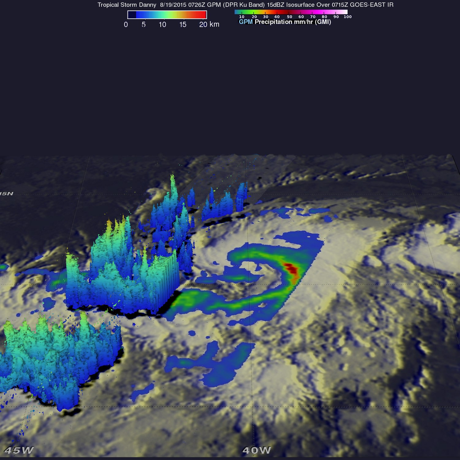
On Aug. 19, NASA’s Global Precipitation Measurement (GPM) mission core satellite passed over Danny and analyzed the structure of its rainfall, as seen in this image.

On Aug. 19, 2015 GPM saw Danny's rain structure was still asymmetric as noted by the large rain band (identified by the green arc indicating moderate rain) being located mainly on the eastern side of the storm. Within this rain band, GPM detected rain rates of up to 73.9 mm/hour (shown in darker red).Credits: SSAI/NASA, Hal Pierce
On Aug. 19, 2015 GPM saw Danny’s rain structure was still asymmetric as noted by the large rain band (identified by the green arc indicating moderate rain) being located mainly on the eastern side of the storm. Within this rain band, GPM detected rain rates of up to 73.9 mm/hour (shown in darker red).Credits: SSAI/NASA, Hal Pierce

A research team at NASA’s Goddard Space Flight Center in Greenbelt, Maryland, created a 3-D rendering of Danny using data from the GPM DPR (Dual-frequency Precipitation Radar) instrument.

“GPM showed that Danny was still in the process of becoming organized. The rain structure was still very asymmetric as noted by a large rain band being located mainly on the eastern side of the storm. Within this rain band, GPM detected rain rates of up to 73.9 mm/hour. At the time of this image, Danny was still a minimal tropical storm with sustained winds estimated at 50 mph by the National Hurricane Center (NHC),” said officials.

And dont forget that you can watch Commander Scott Kelly and his five international crew mates on a regular basis as they soar overhead. Just click on NASA’s Spot the Station link and plug in your location.

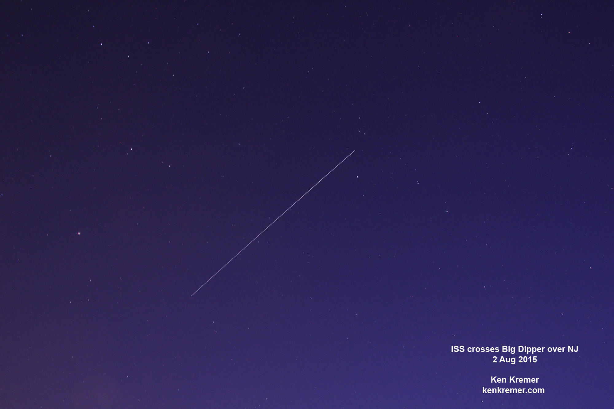
ISS crosses the Big Dipper over NJ.  Credit: Ken Kremer/kenkremer.com
ISS crosses the Big Dipper over NJ. Credit: Ken Kremer/kenkremer.com

Stay tuned here for Ken’s continuing Earth and planetary science and human spaceflight news.

Ken Kremer

Curiosity Snaps Stunning One of a Kind Belly Selfie At Buckskin Mountain Base Drill Site

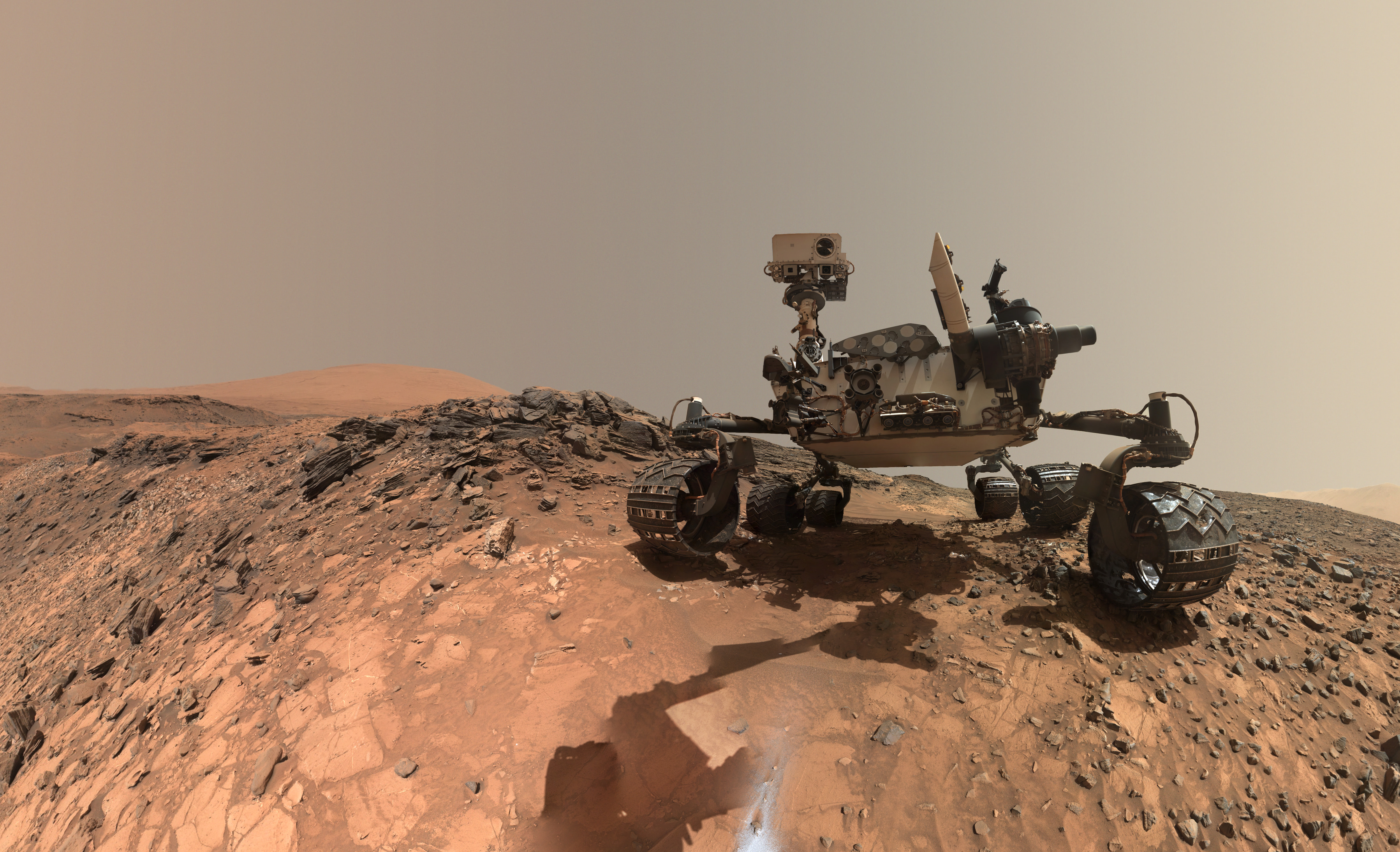
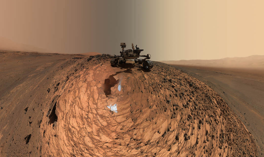
This low-angle self-portrait of NASA's Curiosity Mars rover shows the vehicle at the site from which it reached down to drill into a rock target called "Buckskin." The MAHLI camera on Curiosity's robotic arm took multiple images on Aug. 5, 2015, that were stitched together into this selfie. Credits: NASA/JPL-Caltech/MSSS

This low-angle self-portrait of NASA’s Curiosity Mars rover shows the vehicle at the site from which it reached down to drill into a rock target called “Buckskin.” The MAHLI camera on Curiosity’s robotic arm took multiple images on Aug. 5, 2015, that were stitched together into this selfie. Credits: NASA/JPL-Caltech/MSSS
More selfie and drilling mosaics below[/caption]

NASA’s Curiosity rover has snapped a stunningly beautiful, one of a kind ‘belly selfie’ amidst the painstaking ‘Buckskin’ drill campaign at the Martian mountain base marking the third anniversary since her touchdown on the Red Planet.

The unique self portrait was taken from a low-angle for the first time and shows the six wheeled rover at work collecting her seventh drilled sample at the ‘Buckskin’ rock target earlier this month in the “Marias Pass” area of lower Mount Sharp.

‘Buckskin’ is also unique in a fabulously scientifically way because the rover discovered a new type of Martian rock that’s surprisingly rich in silica – and unlike any other targets found before.

The low camera angle is what enables the awesome Buckskin belly selfie. It’s a distinctively dramatic view and actually stitched from 92 images captured by the Mars Hand Lens Imager (MAHLI) on Aug. 5, 2015, or Sol 1065 of the mission.

The high resolution MAHLI color camera is located on the end of the 7 foot-long (2.1 meter-long) robotic arm.

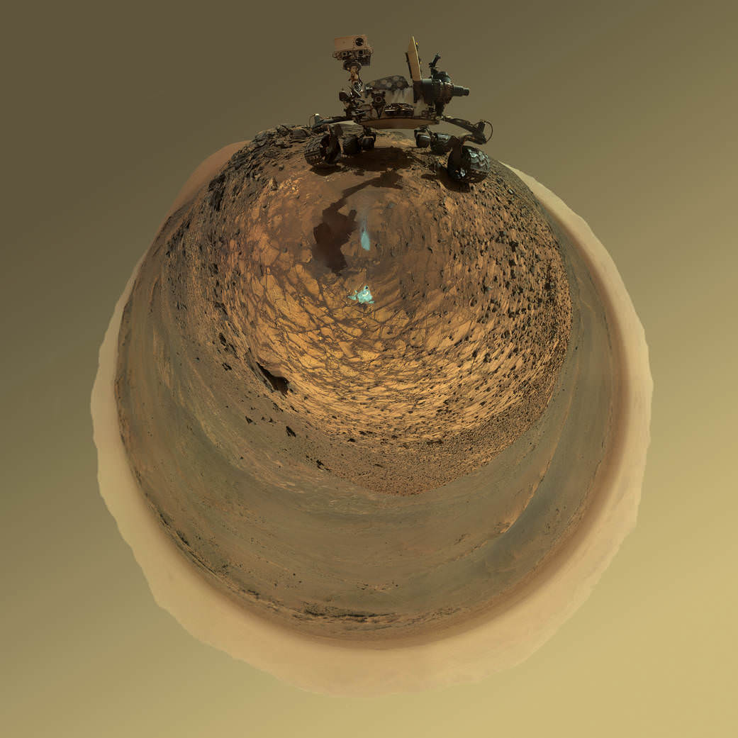
This version of a self-portrait of NASA's Curiosity Mars rover at a drilling site called "Buckskin" is presented as a stereographic projection, which shows the horizon as a circle. The MAHLI camera on Curiosity's robotic arm took dozens of component images for this selfie on Aug. 5, 2015.  Credits: NASA/JPL-Caltech/MSSS
This version of a self-portrait of NASA’s Curiosity Mars rover at a drilling site called “Buckskin” is presented as a stereographic projection, which shows the horizon as a circle. The MAHLI camera on Curiosity’s robotic arm took dozens of component images for this selfie on Aug. 5, 2015. Credits: NASA/JPL-Caltech/MSSS

Indeed the car-sized rover has taken spectacular selfies several times before during her three year long trek across the Martian surface, since the August 2012 landing inside Mars’ Gale Crater. But for those past selfies the MAHLI camera was hoisted higher to give the perspective of looking somewhat downward and showing the rovers top deck and trio of sample inlet ports.

In this case, the rover team specifically commanded Curiosity to position “the camera lower in relation to the rover body than for any previous full self-portrait of Curiosity,” said NASA officials.

Two patches of gray colored powdered rock material drilled from Buckskin are visible in the selfie scene, in front of the rover.

“The patch closer to the rover is where the sample-handling mechanism on Curiosity’s robotic arm dumped collected material that did not pass through a sieve in the mechanism. Sieved sample material was delivered to laboratory instruments inside the rover. The patch farther in front of the rover, roughly triangular in shape, shows where fresh tailings spread downhill from the drilling process.”

Prior selfies were taken at the “Rocknest” (http://photojournal.jpl.nasa.gov/catalog/PIA16468), “John Klein” (http://photojournal.jpl.nasa.gov/catalog/PIA16937), “Windjana” (http://photojournal.jpl.nasa.gov/catalog/PIA18390) and “Mojave” drill sites.

Basically in the Sol 1065 belly selfie at “Buckskin” we see the underbelly of the rover and all six wheels along with a complete self portrait.

This version of a self-portrait of NASA's Curiosity Mars rover at a drilling site called "Buckskin" is presented as a stereographic projection, which shows the horizon as a circle. The MAHLI camera on Curiosity's robotic arm took dozens of component images for this selfie on Aug. 5, 2015.  Credits: NASA/JPL-Caltech/MSSS
This version of a self-portrait of NASA’s Curiosity Mars rover at a drilling site called “Buckskin” is presented as a stereographic projection, which shows the horizon as a circle. The MAHLI camera on Curiosity’s robotic arm took dozens of component images for this selfie on Aug. 5, 2015. Credits: NASA/JPL-Caltech/MSSS

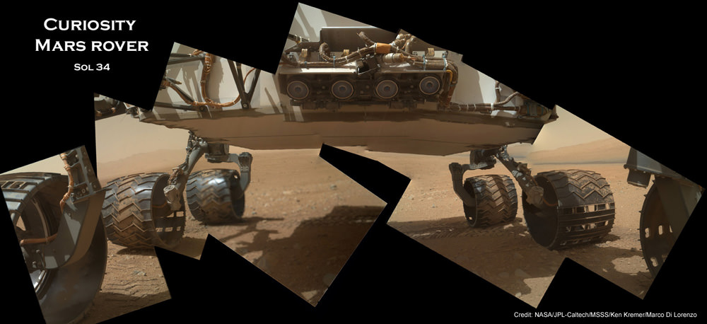
On several prior occasions, MAHLI was used to image just the underbelly and wheels to aid in inspecting the wheels to look for signs of damage inflicted by sharp-edged Martian rocks poking holes in the aluminum wheels.

Underbelly view of Curiosity rover and wheels on Sol 34.  Credit: NASA/JPL/MSSS/Ken Kremer/Marco Di Lorenzo
Underbelly view of Curiosity rover and wheels on Sol 34, Sept. 9, 2012. Credit: NASA/JPL/MSSS/Ken Kremer/Marco Di Lorenzo

Each wheel measures 20 inches (50 centimeters) in diameter and about 16 inches (40 centimeters) wide. And the MAHLI monitoring images have shown the effects of increasing wear and tear that ultimately forced the rover drivers to alter Curiosity’s driving route on the crater floor in favor of smoother and less rocky terrain imparting less damage to the critical wheels.

If you take a close look at the new selfie up top, you’ll see a small rock stuck onto Curiosity’s left middle wheel (on the right in this head-on view). The rock was seen also in prior wheel monitoring images taken three weeks ago.

“The selfie at Buckskin does not include the rover’s robotic arm beyond a portion of the upper arm held nearly vertical from the shoulder joint. With the wrist motions and turret rotations used in pointing the camera for the component images, the arm was positioned out of the shot in the frames or portions of frames used in this mosaic,” according to officials.

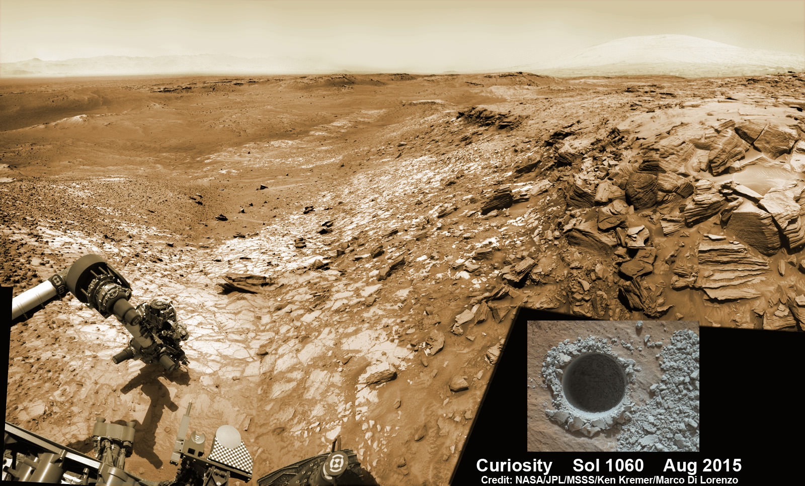
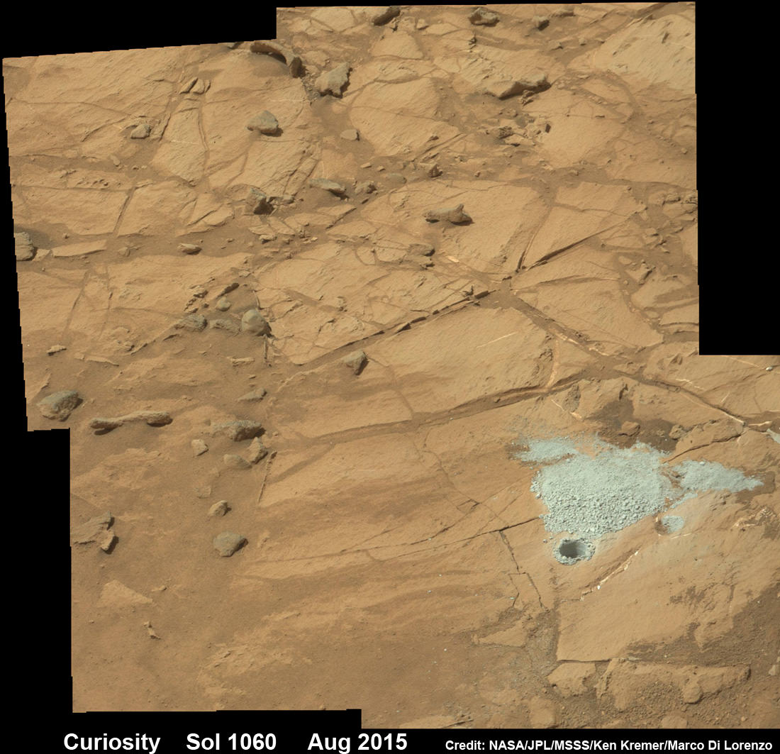
The drilling campaign into “Buckskin” was successfully conducted on Sol 1060 (July 30, 2015) at the bright toned “Lion” outcrop to a full depth of about 2.6 inches (6.5 centimeters) and approximately 1.6 cm (0.63 inch) diameter.

Curiosity extends robotic arm and conducts sample drilling at “Buckskin” rock target at bright toned “Lion” outcrop at the base of Mount Sharp on Mars, seen at right.   Gale Crater eroded rim seen in the distant background at left, in this composite multisol mosaic of navcam raw images taken to Sol 1059, July 30, 2015.  Navcam camera raw images stitched and colorized. Inset: MAHLI color camera up close image of full depth drill hole at “Buckskin” rock target on Sol 1060.  Credit:  NASA/JPL-Caltech/MSSS/Ken Kremer/kenkremer.com/Marco Di Lorenzo
Curiosity extends robotic arm and conducts sample drilling at “Buckskin” rock target at bright toned “Lion” outcrop at the base of Mount Sharp on Mars, seen at right. Gale Crater eroded rim seen in the distant background at left, in this composite multisol mosaic of navcam raw images taken to Sol 1059, July 30, 2015. Navcam camera raw images stitched and colorized. Inset: MAHLI color camera up close image of full depth drill hole at “Buckskin” rock target on Sol 1060. Credit: NASA/JPL-Caltech/MSSS/Ken Kremer/kenkremer.com/Marco Di Lorenzo

You can also see another perspective of the rover at work while reaching out with the robotic arm and drilling into ‘Buckskin’ as illustrated in our mosaics of mastcam and navcam camera raw images created by the image processing team of Ken Kremer and Marco Di Lorenzo.

The main bore hole was drilled next to the initial mini hole test and shows the indicative residue of grey colored tailings from the Martian subsurface seen distributed around the new hole.

Curiosity rover successfully drills into Martian outcrop  at Buckskin rock target at current work site at base of Mount Sharp in August 2015, in this mosaic showing full depth drill hole and initial test hole, with grey colored subsurface tailings and mineral veins on surrounding Red Planet terrain.  This high resolution photo mosaic is a multisol composite of color images taken by the mast mounted Mastcam-100 color camera up to Sol 1060, July 31, 2015.   Credit:  NASA/JPL-Caltech/Ken Kremer/kenkremer.com/Marco Di Lorenzo
Curiosity rover successfully drills into Martian outcrop at Buckskin rock target at current work site at base of Mount Sharp in August 2015, in this mosaic showing full depth drill hole and initial test hole, with grey colored subsurface tailings and mineral veins on surrounding Red Planet terrain. This high resolution photo mosaic is a multisol composite of color images taken by the mast mounted Mastcam-100 color camera up to Sol 1060, July 31, 2015. Credit: NASA/JPL-Caltech/Ken Kremer/kenkremer.com/Marco Di Lorenzo

Curiosity has now moved on from the “Marias Pass” area.

Curiosity recently celebrated 1000 Sols of exploration on Mars on May 31, 2015 – detailed here with our Sol 1000 mosaic also featured at Astronomy Picture of the Day on June 13, 2015.

As of today, Sol 1080, August 20, 2015, she has driven some 6.9 miles (11.1 kilometers) kilometers and taken over 260,000 amazing images.

Curiosity rover scans toward south east around Marias Pass area at the base of Mount Sharp on Mars on Sol 1074, Aug. 14, 2015 in this photo mosaic stitched from Mastcam color camera raw images.  Credit: NASA/JPL/MSSS/Marco Di Lorenzo/Ken Kremer/kenkremer.com
Curiosity rover scans toward south east around Marias Pass area at the base of Mount Sharp on Mars on Sol 1074, Aug. 14, 2015 in this photo mosaic stitched from Mastcam color camera raw images. Credit: NASA/JPL/MSSS/Marco Di Lorenzo/Ken Kremer/kenkremer.com

Curiosity has already accomplished her primary objective of discovering a habitable zone on the Red Planet – at the Yellowknife Bay area – that contains the minerals necessary to support microbial life in the ancient past when Mars was far wetter and warmer billions of years ago.

Stay tuned here for Ken’s continuing Earth and planetary science and human spaceflight news.

Ken Kremer

NASA Invites Public to ‘Send Your Name to Mars’ on InSight – Next Red Planet Lander

Sign up to send your name to Mars on InSight, NASA’s next mission to Mars launching in March 2016. Credit: NASA

Sign up to send your name to Mars on InSight, NASA’s next mission to Mars launching in March 2016. Credit: NASA
Sign up link below – don’t delay![/caption]

Calling space fans worldwide: Now is your chance to participate in NASA’s human ‘Journey to Mars’ initiative and NASA’s next robotic mission to Mars – the InSight lander launching to the Red Planet next spring.

NASA invites you to ‘Send Your Name to Mars’ on a silicon microchip aboard the InSight probe slated for blastoff on March 4, 2016 from Vandenberg Air Force Base, California.

InSight’s science goal is totally unique – to “listen to the heart of Mars to find the beat of rocky planet formation.”

The public can submit their names for inclusion on a dime-sized microchip that will travel on a variety of spacecraft voyaging to destinations beyond low-Earth orbit, including Mars.

“Our next step in the journey to Mars is another fantastic mission to the surface,” said Jim Green, director of planetary science at NASA Headquarters in Washington.

“By participating in this opportunity to send your name aboard InSight to the Red Planet, you’re showing that you’re part of that journey and the future of space exploration.”

In just the first 24 hours over 67,000 Mars enthusiasts have already signed up!

But time is of the essence since the deadline to submit your name is soon: Sept. 8, 2015.

How can you sign up to fly on InSight? Is there a certificate?

NASA has made it easy to sign up.

To send your name to Mars aboard InSight, click on this weblink posted online by NASA:

http://go.usa.gov/3Aj3G

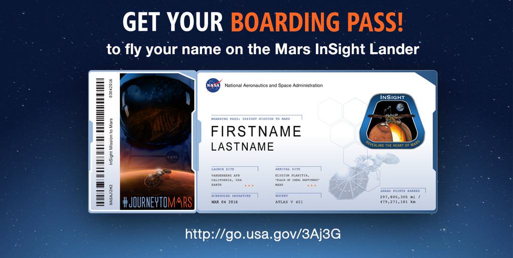
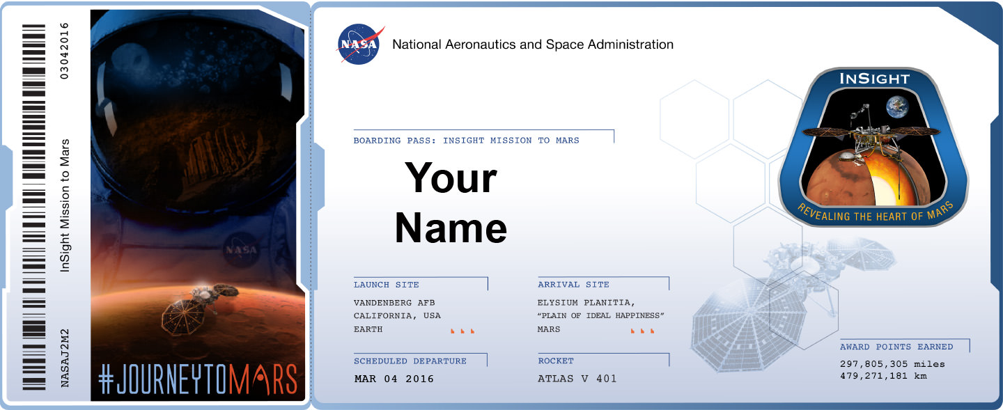
And you can also print out an elegant looking ‘Boarding Pass’ that looks like this:

Boarding Pass for NASA’s InSight Mission to Mars - launching from Vandenberg Air Force Base, California in March 2016.  Credit: NASA
Boarding Pass with frequent flyer miles for NASA’s InSight Mission to Mars – launching from Vandenberg Air Force Base, California in March 2016. Credit: NASA

Furthermore the ‘Boarding Pass’ also comes with a listing of your “frequent flier” points accumulated by your participation in NASA’s ‘fly-your-name opportunity’ that will span multiple missions and multiple decades beyond low Earth orbit.

InSight represents the second ‘fly-your-name opportunity’ in NASA’s journey to Mars program. The uncrewed Orion EFT-1 mission launched on Dec. 5, 2014 was the first chance for space fans to collect ‘Journey to Mars’ points by sending your names to space.

The ‘Send Your Name to Mars’ campaign for Orion EFT-1 was a huge success.

Over 1.38 million people flew on the silicon chip aboard the maiden flight of Orion, the NASA capsule that will eventually transport humans to the Red Planet in the 2030s.

Don’t dawdle. Because after InSight, you’ll have to wait about three years until late 2018 and the blastoff of the next Orion capsule on NASA’s Exploration Mission-1 (EM-1) for you next chance to accumulate “frequent flier” points on a ‘Journey to Mars’ mission.

Orion EM-1 will launch atop NASA’s mammoth Space Launch System (SLS) rocket, and NASA just conducted a key test firing on Aug. 13 of the first stage engines that will power the stack to on a mission to the Moon – detailed in my recent story here.

InSight, which stands for Interior Exploration Using Seismic Investigations, Geodesy and Heat Transport, is a stationary lander.

It will join NASA’s surface science exploration fleet currently comprising of the Curiosity and Opportunity missions which by contrast are mobile rovers.

InSight is the first mission to understand the interior structure of the Red Planet. Its purpose is to elucidate the nature of the Martian core, measure heat flow and sense for “Marsquakes.”

“It will place the first seismometer directly on the surface of Mars to measure Martian quakes and use seismic waves to learn about the planet’s interior. It also will deploy a self-hammering heat probe that will burrow deeper into the ground than any previous device on the Red Planet. These and other InSight investigations will improve our understanding about the formation and evolution of all rocky planets, including Earth,” says NASA.

NASA's InSight Mars lander spacecraft in a Lockheed Martin clean room near Denver. As part of a series of deployment tests, the spacecraft was commanded to deploy its solar arrays in the clean room to test and verify the exact process that it will use on the surface of Mars.  Credits: NASA/JPL-Caltech/Lockheed Martin
NASA’s InSight Mars lander spacecraft in a Lockheed Martin clean room near Denver. As part of a series of deployment tests, the spacecraft was commanded to deploy its solar arrays in the clean room to test and verify the exact process that it will use on the surface of Mars. Credits: NASA/JPL-Caltech/Lockheed Martin

The countdown clock is ticking relentlessly towards liftoff in less than seven months time in March 2016.

Insight promises to ‘science the sh**’ out of the heart of Mars!

It is funded by NASA’s Discovery Program as well as several European national space agency’s and countries. Germany and France are providing InSight’s two main science instruments; The HP3 heat probe and the SEIS seismometer through the Deutsches Zentrum für Luft- und Raumfahrt. or German Aerospace Center (DLR) and the Centre National d’Etudes Spatiales (CNES).

“Together, humans and robotics will pioneer Mars and the solar system,” says Green.

InSight Boarding pass

Stay tuned here for Ken’s continuing Earth and planetary science and human spaceflight news.

Ken Kremer

Indian Mars Orbiter Shoots Spectacular New Images of Sheer Canyon and Curiosity’s Crater

This view over the Ophir Chasma canyon on the Martian surface was taken by the Mars Colour Camera aboard India’s Mars Orbiter Mission (MOM). Ophir Chasma is a canyon in the Coprates quadrangle located at 4° south latitude and 72.5° west longitude. It is part of the Valles Marineris canyon system. Credit: ISRO

India’s space agency has released a spectacular new batch of images taken by everyone’s favorite MOM – the Mars Orbiter Mission – the nation’s first probe ever dispatched to the Red Planet and which achieved orbit nearly a year ago.

The Indian Space Research Organization (ISRO) has published a beautiful gallery of images featuring a steep and stunning Martian canyon and the landing site of NASA’s Curiosity Mars Science Laboratory rover, and more.

The lead image was taken over the Ophir Chasma canyon on the Martian surface by the Mars Colour Camera aboard India’s Mars Orbiter Mission.

Ophir Chasma is a canyon in the Coprates quadrangle located at 4° south latitude and 72.5° west longitude. It is part of the Valles Marineris – the ‘Grand Canyon of Mars’ – and the largest known canyon in the Solar System.

The image was captured on July 19, 2015 from an altitude of 1857 kilometers (1154 miles). It has with a resolution of 96 meters.

The steep walled Ophir Chasma canyon contains many layers and the floors contain large deposits of layered materials, perhaps even sulfates.

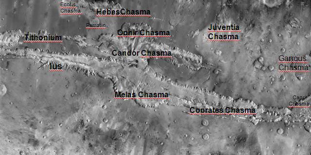
Ophir Chasma is about 317 kilometers long and about 8 to 10 kilometers deep located near the center of Valles Marineris – see map below.

Valles Marineris stretches over 4,000 km (2,500 mi) across the Red Planet, is as much as 600 km wide and measures as much as 10 kilometers (6 mi) deep. It is nearly as wide as the United States.

Here’s an illuminating and magnificent 3D portrayal of Ophir Chasma created by Indian scientists that gives a sense of the canyons scale, sheer walls and cliffs and depth:

3D portrayals of Ophir Chasma terrain based on images taken by India’s Mars Orbiter Mission color camera on 19 July 2015 . Credit: ISRO

The newest images were snapped after the spacecraft exited the communications blackout encountered by all of Earth’s invasion fleet of Red Planet orbiters and rovers during the recent conjunction period when Mars was behind the sun during much of June.

See the prior image release from ISRO in my MOM story – here.

Here’s a wider view of Valles Marineris showing Ophir Chasma in a previously published MOM image from ISRO.

Valles Marineris from India’s Mars Mission.   Credit: ISRO
Valles Marineris from India’s Mars Mission. Credit: ISRO

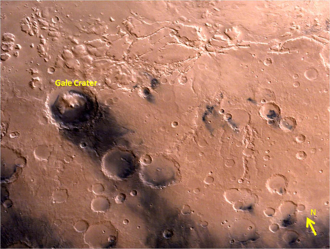
ISRO also released a delightful new image of Gale Crater and the surrounding vicinity.

Gale Crater is the landing site of NASA’s Curiosity rover. MOM took the image from an altitude of 9004 kilometers.

Gale Crater - landing site of NASA’s Curiosity rover - and vicinity as seen by India’s Mars Orbiter Mission from an altitude of 9004 km.  Gale crater is home to humongous Mount Sharp which rises 5.5 km from the crater floor and is easily visible in this photo.   Credit: ISRO
Gale Crater – landing site of NASA’s Curiosity rover – and vicinity as seen by India’s Mars Orbiter Mission from an altitude of 9004 km. Gale crater is home to humongous Mount Sharp which rises 5.5 km from the crater floor and is easily visible in this photo. Credit: ISRO

Gale Crater is home to humongous Mount Sharp, a mountain that rises 5.5 kilometers (3.4 miles) from the crater floor and is easily visible in the photo from MOM. The crater is 154 kilometers (96 mi) wide.

Curiosity is currently exploring the foothills of Mount Sharp around the top of the image – which shows a rather different perspective from what we’ve seen from prior familiar orbital imagery snapped by several NASA and ESA orbiters.

The 1 ton rover recently celebrated the 3rd anniversary since its nailbiting touchdown inside Gale crater. And the new wider angle image from MOM gives a fabulous sense of exactly why a highly precise landing was essential – otherwise it would have been doomed.

Curiosity recently drilled into the “Buckskin” target at an outcrop at the foothills of Mount Sharp. See the mountain in our ground level mosaic from the crater floor. And its kind of neat to actually imagine Curiosity sitting there while perusing MOM’s photo.

Curiosity extends robotic arm and conducts sample drilling at “Buckskin” rock target at bright toned “Lion” outcrop at the base of Mount Sharp on Mars, seen at right.   Gale Crater eroded rim seen in the distant background at left, in this composite multisol mosaic of navcam raw images taken to Sol 1059, July 30, 2015.  Navcam camera raw images stitched and colorized. Inset: MAHLI color camera up close image of full depth drill hole at “Buckskin” rock target on Sol 1060.  Credit:  NASA/JPL-Caltech/MSSS/Ken Kremer/kenkremer.com/Marco Di Lorenzo
Curiosity extends robotic arm and conducts sample drilling at “Buckskin” rock target at bright toned “Lion” outcrop at the base of Mount Sharp on Mars, seen at right. Gale Crater eroded rim seen in the distant background at left, in this composite multisol mosaic of navcam raw images taken to Sol 1059, July 30, 2015. Navcam camera raw images stitched and colorized. Inset: MAHLI color camera up close image of full depth drill hole at “Buckskin” rock target on Sol 1060. Credit: NASA/JPL-Caltech/MSSS/Ken Kremer/kenkremer.com/Marco Di Lorenzo

MOM’s goal is to study Mars atmosphere, surface environments, morphology, and mineralogy with a 15 kg (33 lb) suite of five indigenously built science instruments. It is also sniffing for methane, a potential marker for biological activity.

MOM is India’s first deep space voyager to explore beyond the confines of her home planets influence and successfully arrived at the Red Planet after the “history creating” orbital insertion maneuver on Sept. 23/24, 2014 following a ten month journey from Earth.

The Indian probe arrived just after NASA’s MAVEN Mars orbiter, the first mission specifically targeted to study Mars tenuous upper atmosphere and the escape rates of atmospheric constituents.

MOM swoops around Mars in a highly elliptical orbit whose nearest point to the planet (periapsis) is at about 421 km and farthest point (apoapsis) at about 76,000 km, according to ISRO.

It takes MOM about 3.2 Earth days or 72 hours to orbit the Red Planet.

MOM was launched on Nov. 5, 2013 from India’s spaceport at the Satish Dhawan Space Centre, Sriharikota, atop the nations indigenous four stage Polar Satellite Launch Vehicle (PSLV) which placed the probe into its initial Earth parking orbit.

The $73 million MOM mission was expected to last at least six months. In March, ISRO extended the mission duration for another six months since its healthy, the five science instruments are operating fine and it has sufficient fuel reserves.

Including MOM, Earth’s invasion fleet at the Red Planet numbers a total of seven spacecraft comprising five orbiters from NASA, ESA and ISRO as well as the sister pair of mobile surface rovers from NASA – Curiosity and Opportunity.

Stay tuned here for Ken’s continuing Earth and planetary science and human spaceflight news.

Ken Kremer

Location of Ophir Chasma canyon inside this annotated map of Valles Marineris created from the THEMIS camera on NASA’s Mars Odyssey orbiter. Credit: NASA
Olympus Mons, Tharsis Bulge trio of volcanoes and Valles Marineris from ISRO's Mars Orbiter Mission. Note the clouds and south polar ice cap.   Credit: ISRO
Olympus Mons, Tharsis Bulge trio of volcanoes and Valles Marineris from ISRO’s Mars Orbiter Mission. Note the clouds and south polar ice cap. Credit: ISRO

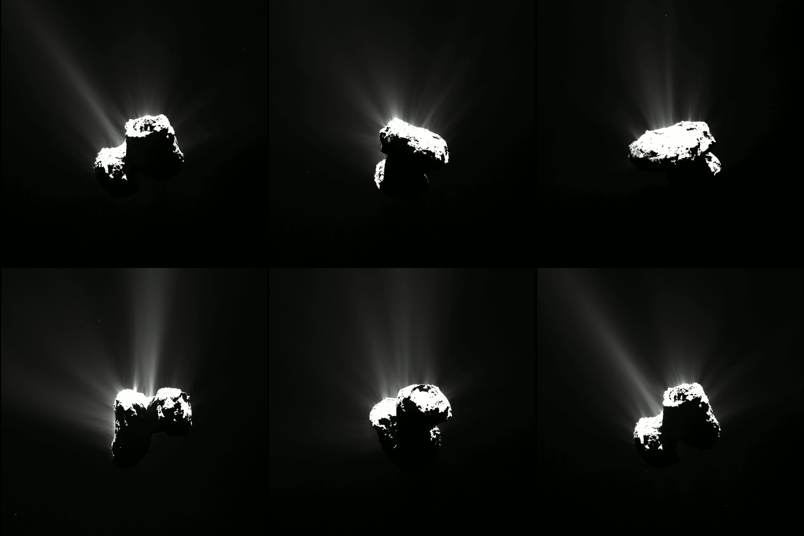
Spectacular Celestial Fireworks Commemorate Perihelion Passage of Rosetta’s Comet

Sequence of OSIRIS narrow-angle camera images from 12 August 2015, just a few hours before the comet reached perihelion. Credits: ESA/Rosetta/MPS for OSIRIS Team MPS/UPD/LAM/IAA/SSO/INTA/UPM/DASP/IDA

Sequence of OSIRIS narrow-angle camera images from 12 August 2015, just a few hours before the comet reached perihelion. Credits: ESA/Rosetta/MPS for OSIRIS Team MPS/UPD/LAM/IAA/SSO/INTA/UPM/DASP/IDA
See hi res images below[/caption]

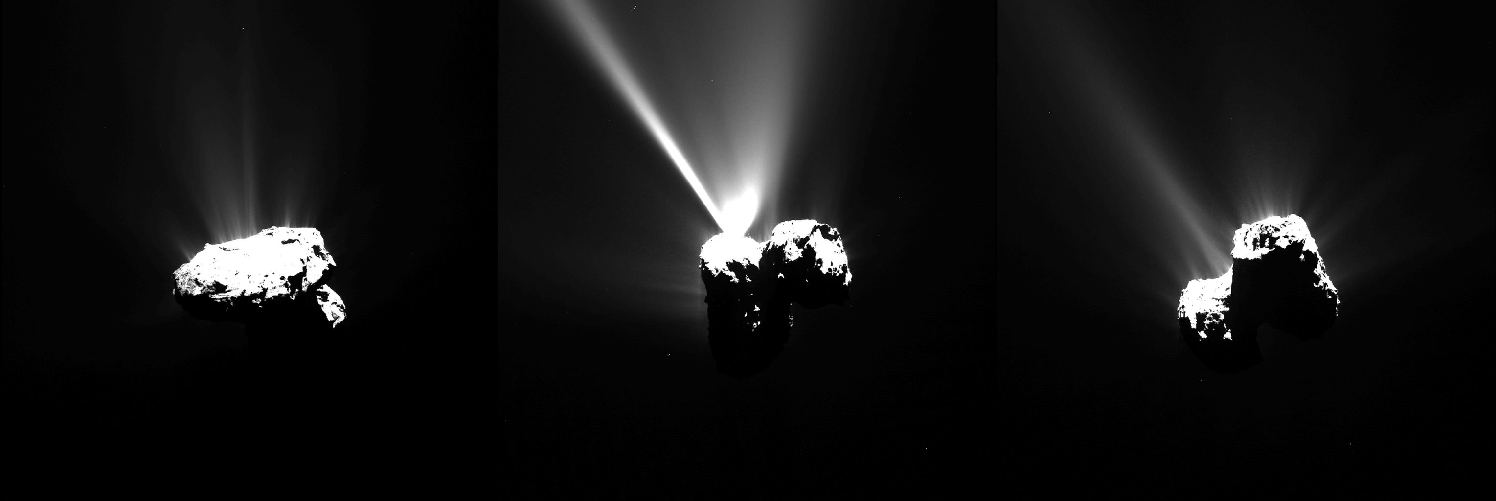
A spectacular display of celestial fireworks like none ever witnessed before, burst forth from Rosetta’s comet right on time – commemorating the Europeans spacecraft’s history making perihelion passage after a year long wait of mounting excitement and breathtaking science.

As the European Space Agency’s (ESA’s) Rosetta marked its closest approach to the Sun (perihelion) at exactly 02:03 GMT on Thursday, August 13, 2015, while orbiting Comet 67P/Churyumov–Gerasimenko, its suite of 11 state-of-the-art science instruments, cameras and spectrometers were trained on the utterly bizarre bi-lobed body to capture every facet of the comet’s nature and environment for analysis by the gushing science teams.

And the perihelion passage did not disappoint – living up to its advance billing by spewing forth an unmatched display of otherworldly outbursts of gas jets and dust particles due to surface heating from the warming effects of the sun as the comet edged ever closer, coming within 186 million kilometers of mighty Sol.

ESA has released a brand new series of images, shown above and below, documenting sparks flying – as seen by Rosetta’s OSIRIS narrow-angle camera and NAVCAM wider angle cameras on August 12 and 13 – just a few hours before the rubby ducky shaped comet reached perihelion along its 6.5-year orbit around the sun.

Images of Comet 67P/C-G taken with OSIRIS narrow-angle camera on 12 August 2015, just a few hours before the comet reached perihelion, about 330 km from the comet. The individual images are also available below. Credits: ESA/Rosetta/MPS for OSIRIS Team MPS/UPD/LAM/IAA/SSO/INTA/UPM/DASP/IDA

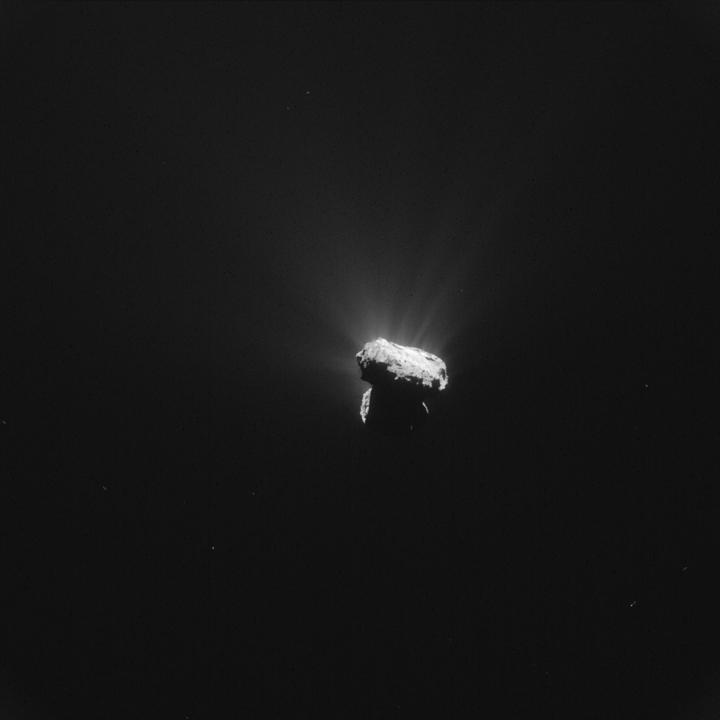
Indeed the navcam camera image below was taken just an hour before the moment of perihelion, at 01:04 GMT, from a distance of around 327 kilometers!

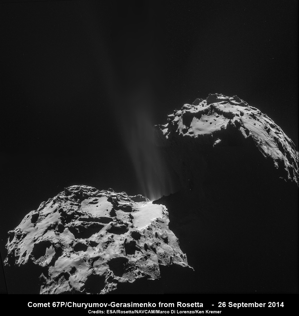
Frozen ices are seen blasting away from the comet in a hail of gas and dust particles as rising solar radiation heats the nucleus and fortifies the comet’s atmosphere, or coma, and its tail.

Comet at perihelion.  Single frame Rosetta navigation camera image acquired at 01:04 GMT on 13 August 2015, just one hour before Comet 67P/Churyumov–Gerasimenko reached perihelion – the closest point to the Sun along its 6.5-year orbit. The image was taken around 327 km from the comet. It has a resolution of 28 m/pixel, measures 28.6 km across and was processed to bring out the details of the comet's activity. Credits: ESA/Rosetta/NAVCAM – CC BY-SA IGO 3.0
Comet at perihelion. Single frame Rosetta navigation camera image acquired at 01:04 GMT on 13 August 2015, just one hour before Comet 67P/Churyumov–Gerasimenko reached perihelion – the closest point to the Sun along its 6.5-year orbit. The image was taken around 327 km from the comet. It has a resolution of 28 m/pixel, measures 28.6 km across and was processed to bring out the details of the comet’s activity. Credits: ESA/Rosetta/NAVCAM – CC BY-SA IGO 3.0

After a decade long chase of over 6.4 billion kilometers (4 Billion miles), ESA’s Rosetta spacecraft arrived at the pockmarked Comet 67P/Churyumov-Gerasimenko exactly a year ago on Aug. 6, 2014 for history’s first ever attempt to orbit a comet for long term study.

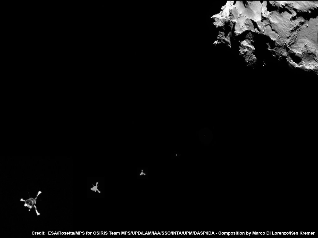
In the interim, Rosetta also deployed the piggybacked Philae lander for history’s first landing on a comet on Nov. 12, 2014.

In fact, measurements from Rosetta’s science instruments confirm the comet is belching a thousand times more water vapor today than was observed during Rosetta’s arrival a year ago. It’s spewing some 300 kg of water vapour every second now, compared to just 300 g per second upon arrival. That equates to two bathtubs per second now in Aug. 2015 vs. two small glasses of water per second in Aug. 2014.

Besides gas, 1000 kg of dust per second is simultaneously erupting from the nucleus, “creating dangerous working conditions for Rosetta,” says ESA.

“In recent days, we have been forced to move even further away from the comet. We’re currently at a distance of between 325 km and 340 km this week, in a region where Rosetta’s startrackers can operate without being confused by excessive dust levels – without them working properly, Rosetta can’t position itself in space,” comments Sylvain Lodiot, ESA’s spacecraft operations manager, in an ESA statement.

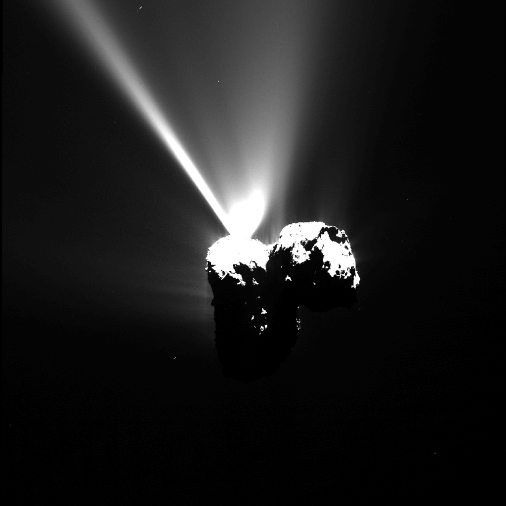
Here’s an OSIRIS image taken just hours prior to perihelion, that’s included in the lead animation of this story.

OSIRIS NAC image of Comet 67P/C-G taken on 12 August 2015 at 17:35 GMT. Credits: ESA/Rosetta/MPS for OSIRIS Team MPS/UPD/LAM/IAA/SSO/INTA/UPM/DASP/IDA

The period of the comet’s peak intensity, as seen in all these images, is expected to continue past perihelion for several weeks at least and fulfils the dreams of a scientific goldmine for all the research teams and hundreds of researchers involved with Rosetta and Philae.

“Activity will remain high like this for many weeks, and we’re certainly looking forward to seeing how many more jets and outburst events we catch in the act, as we have already witnessed in the last few weeks,” says Nicolas Altobelli, acting Rosetta project scientist.

And Rosetta still has lots of fuel, and just as important – funding – to plus up its ground breaking science discoveries.

ESA recently granted Rosetta a 9 month mission extension to continue its research activities as well as having been given the chance to accomplish one final and daring historic challenge.

Engineers will attempt to boldly go and land the probe on the undulating surface of the comet.

Officials with the European Space Agency (ESA) gave the “GO” on June 23 saying “The adventure continues” for Rosetta to march forward with mission operations until the end of September 2016.

If all continues to go well “the spacecraft will most likely be landed on the surface of Comet 67P/Churyumov-Gerasimenko” said ESA.

ESA Philae lander approaches comet 67P/Churyumov–Gerasimenko on 12 November 2014 as imaged from Rosetta orbiter after deployment and during seven hour long approach for 1st ever  touchdown on a comets surface.  Credit:  ESA/Rosetta/MPS for OSIRIS Team MPS/UPD/LAM/IAA/SSO/INTA/UPM/DASP/IDA - Composition by Marco Di Lorenzo/Ken Kremer
ESA Philae lander approaches comet 67P/Churyumov–Gerasimenko on 12 November 2014 as imaged from Rosetta orbiter after deployment and during seven hour long approach for 1st ever touchdown on a comets surface. Credit: ESA/Rosetta/MPS for OSIRIS Team MPS/UPD/LAM/IAA/SSO/INTA/UPM/DASP/IDA – Composition by Marco Di Lorenzo/Ken Kremer

Stay tuned here for Ken’s continuing Earth and planetary science and human spaceflight news.

Ken Kremer

Jets of gas and dust are blasting from the active neck of comet 67P/Churyumov-Gerasimenko in this photo mosaic assembled from four images taken on 26 September 2014 by the European Space Agency’s Rosetta spacecraft at a distance of 26.3 kilometers (16 miles) from the center of the comet. Credit: ESA/Rosetta/NAVCAM/Marco Di Lorenzo/Ken Kremer/kenkremer.com