Milestone Test Firing of NASA’s SLS Monster Rocket Engine Advances Human Path to Deep Space

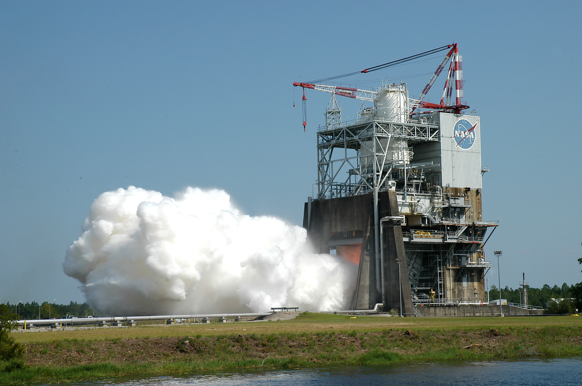
During a 535-second test on August 13, 2015, operators ran the Space Launch System (SLS) RS-25 rocket engine through a series of tests at different power levels to collect engine performance data on the A-1 test stand at NASA's Stennis Space Center near Bay St. Louis, Mississippi. Credit: NASA

During a 535-second test on August 13, 2015, operators ran the Space Launch System (SLS) RS-25 rocket engine through a series of tests at different power levels to collect engine performance data on the A-1 test stand at NASA’s Stennis Space Center near Bay St. Louis, Mississippi. Credit: NASA
Story/imagery updated
See video below of full duration hot-fire test
[/caption]

With today’s (Aug. 13) successful test firing of an RS-25 main stage engine for NASA’s Space Launch System (SLS) monster rocket currently under development, the program passed a key milestone advancing the agency on the path to propel astronauts back to deep space at the turn of the decade.

The 535 second long test firing of the RS-25 development engine was conducted on the A-1 test stand at NASA’s Stennis Space Center near Bay St. Louis, Mississippi – and ran for the planned full duration of nearly 9 minutes, matching the time they will fire during an actual SLS launch.

All indications are that the hot fire test apparently went off without a hitch, on first look.

“We ran the full duration and met all test objectives,” said Steve Wofford, SLS engine manager, on NASA TV following today’s’ test firing.

“There were no anomalies.” – based on the initial look.

The RS-25 is actually an upgraded version of former space shuttle main engines that were used with a 100% success rate during NASA’s three decade-long Space Shuttle program to propel the now retired shuttle orbiters to low Earth orbit. Those same engines are now being modified for use by the SLS.

Spectators enjoy the view during the Aug. 13, 2015 test firing of the RS-25 engine for NASA’s Space Launch System (SLS) on the A-1 test stand at NASA's Stennis Space Center near Bay St. Louis, Mississippi.  Credit: NASA
Spectators enjoy the view during the Aug. 13, 2015 test firing of the RS-25 engine for NASA’s Space Launch System (SLS) on the A-1 test stand at NASA’s Stennis Space Center near Bay St. Louis, Mississippi. Credit: NASA

“Data collected on performance of the engine at the various power levels will aid in adapting the former space shuttle engines to the new SLS vehicle mission requirements, including development of an all-new engine controller and software,” according to NASA officials .

The engine controller functions as the “brain” of the engine, which checks engine status, maintains communication between the vehicle and the engine and relays commands back and forth.

The core stage (first stage) of the SLS will be powered by four RS-25 engines and a pair of the five-segment solid rocket boosters that will generate a combined 8.4 million pounds of liftoff thrust, making it the most powerful rocket the world has ever seen.

Since shuttle orbiters were equipped with three space shuttle main engines, the use of four RS-25s on the SLS represents another significant change that also required many modifications being thoroughly evaluated as well.

RS-25 test firing in progress on the A-1 test stand at NASA's Stennis Space Center near Bay St. Louis, Mississippi, on Aug. 13, 2015.  Credit: NASA
RS-25 test firing in progress on the A-1 test stand at NASA’s Stennis Space Center near Bay St. Louis, Mississippi, on Aug. 13, 2015. Credit: NASA

The SLS will be some 10 percent more powerful than the Saturn V rockets that propelled astronauts to the Moon, including Neil Armstrong, the human to walk on the Moon during Apollo 11 in July 1969.

SLS will loft astronauts in the Orion capsule on missions back to the Moon by around 2021, to an asteroid around 2025 and then beyond on a ‘Journey to Mars’ in the 2030s – NASA’s overriding and agency wide goal.

Each of the RS-25’s engines generates some 500,000 pounds of thrust. They are fueled by cryogenic liquid hydrogen and liquid oxygen. For SLS they will be operating at 109% of power, compared to a routine usage of 104.5% during the shuttle era. They measure 14 feet tall and 8 feet in diameter.

They have to withstand and survive temperature extremes ranging from -423 degrees F to more than 6000 degrees F.

This video shows the full duration hot-fire test:

NASA has 16 of the RS-25s leftover from the shuttle era and they are all being modified and upgraded for use by the SLS rocket.

Today’s test was the sixth in a series of seven to qualify the modified engines to flight status. The engine ignited at 5:01 p.m. EDT and reached the full thrust level of 512,000 pounds within about 5 seconds.

The hot gas was exhausted out of the nozzle at 13 times the speed of sound.

Since the shuttle engines were designed and built over three decades ago, they are being modified where possible with state of the art components to enhance performance, functionality and ease of operation, by prime contractor Aerojet-Rocketdyne of Sacramento, California.

One of the key objectives of today’s engine firing and the entire hot fire series was to test the performance of a brand new engine controller assembled with modern manufacturing techniques.

“Operators on the A-1 Test Stand at Stennis are conducting the test series to qualify an all-new engine controller and put the upgraded former space shuttle main engines through the rigorous temperature and pressure conditions they will experience during a SLS mission,” says NASA.

“The new controller, or “brain,” for the engine, which monitors engine status and communicates between the vehicle and the engine, relaying commands to the engine and transmitting data back to the vehicle. The controller also provides closed-loop management of the engine by regulating the thrust and fuel mixture ratio while monitoring the engine’s health and status.’

Video caption: RS-25 – The Ferrari of Rocket Engines explained. Credit: NASA

“The RS-25 is the most complicated rocket engine out there on the market, but that’s because it’s the Ferrari of rocket engines,” says Kathryn Crowe, RS-25 propulsion engineer.

“When you’re looking at designing a rocket engine, there are several different ways you can optimize it. You can optimize it through increasing its thrust, increasing the weight to thrust ratio, or increasing its overall efficiency and how it consumes your propellant. With this engine, they maximized all three.”

Engineers will now pour over the data collected from hundreds of data channels in great detail to thoroughly analyze the test results. They will incorporate any findings into future test firings of the RS-25s.

NASA says that testing of RS-25 flight engines is set to start later this fall.

“The RS-25 engine gives SLS a proven, high performance, affordable main propulsion system for deep space exploration. It is one of the most experienced large rocket engines in the world, with more than a million seconds of ground test and flight operations time.”

NASA plans to buy completely new sets of RS-25 engines from Aerojet-Rocketdyne taking full advantage of technological advances and modern manufacturing techniques as well as lessons learned from this hot fire series of engine tests.

The maiden test flight of the SLS is targeted for no later than November 2018 and will be configured in its initial 70-metric-ton (77-ton) version with a liftoff thrust of 8.4 million pounds. It will boost an unmanned Orion on an approximately three week long test flight beyond the Moon and back.

Artist concept of the SLS Block 1 configuration.  Credit: NASA
Artist concept of the SLS Block 1 configuration. Credit: NASA

NASA plans to gradually upgrade the SLS to achieve an unprecedented lift capability of 130 metric tons (143 tons), enabling the more distant missions even farther into our solar system.

The first SLS test flight with the uncrewed Orion is called Exploration Mission-1 (EM-1) and will launch from Launch Complex 39-B at the Kennedy Space Center.
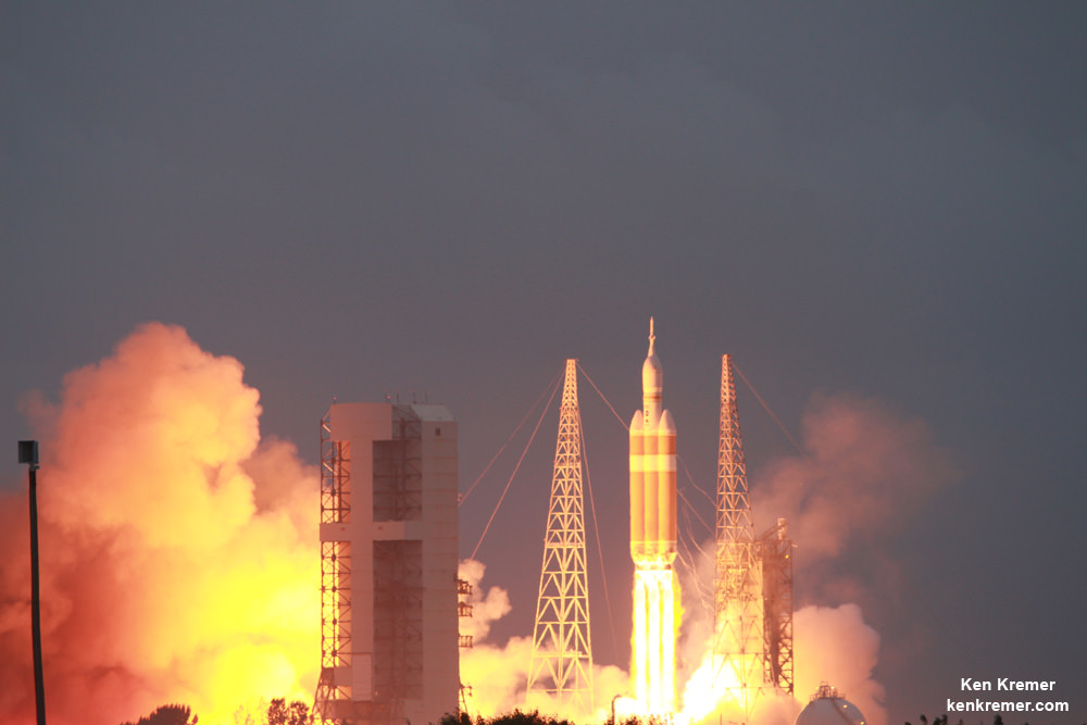
NASA’s first Orion spacecraft blasts off at 7:05 a.m. atop United Launch Alliance Delta 4 Heavy Booster at Space Launch Complex 37 (SLC-37) at Cape Canaveral Air Force Station in Florida on Dec. 5, 2014.   Credit: Ken Kremer - kenkremer.com
NASA’s first Orion spacecraft blasts off at 7:05 a.m. atop United Launch Alliance Delta 4 Heavy Booster at Space Launch Complex 37 (SLC-37) at Cape Canaveral Air Force Station in Florida on Dec. 5, 2014. Credit: Ken Kremer – kenkremer.com

Orion’s inaugural mission dubbed Exploration Flight Test-1 (EFT) was successfully launched on a flawless flight on Dec. 5, 2014 atop a United Launch Alliance Delta IV Heavy rocket Space Launch Complex 37 (SLC-37) at Cape Canaveral Air Force Station in Florida.

Stay tuned here for Ken’s continuing Earth and Planetary science and human spaceflight news.
Ken Kremer

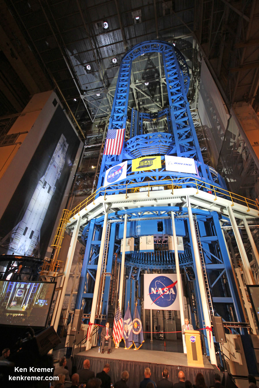
NASA Administrator Charles Bolden officially unveils world’s largest welder to start construction of core stage of NASA's Space Launch System (SLS) rocket at NASA Michoud Assembly Facility, New Orleans, on Sept. 12, 2014. SLS will be the world’s most powerful rocket ever built.  Credit: Ken Kremer - kenkremer.com
NASA Administrator Charles Bolden officially unveils world’s largest welder to start construction of core stage of NASA’s Space Launch System (SLS) rocket at NASA Michoud Assembly Facility, New Orleans, on Sept. 12, 2014. SLS will be the world’s most powerful rocket ever built. Credit: Ken Kremer – kenkremer.com
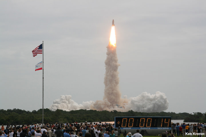
STS-135: Last launch using RS-25 engines that will now power NASA’s SLS deep space exploration rocket. NASA’s 135th and final shuttle mission takes flight on July 8, 2011 at 11:29 a.m. from the Kennedy Space Center in Florida bound for the ISS and the high frontier with Chris Ferguson as Space Shuttle Commander. Credit: Ken Kremer/kenkremer.com

Cygnus Freighter Arrives at Kennedy as Orbital ATK Ramps Up Station Resupply Recovery Efforts via Atlas V

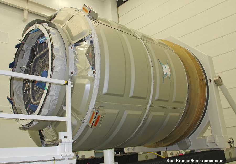
The Cygnus Pressurized Cargo Module for the OA-4 mission arrived at the Kennedy Space Center during August 2015 for processing in preparation for the upcoming CRS space station resupply mission to be launched from Florida in early December 2015. Credit: Orbital ATK

A commercial Cygnus cargo freighter has just arrived at the Kennedy Space Center (KSC) in Florida to begin intensive processing for a critical mission to deliver some four tons of science experiments and supplies to the International Space Station (ISS) atop an Atlas V rocket in early December – as manufacturer Orbital ATK takes a big step in ramping up activities to fulfill its station resupply commitments and recover from the catastrophic launch failure of the firms Antares rocket last October.

Taking advantage of the built in flexibility to launch Cygnus on a variety of rockets, Orbital ATK quickly contracted rocket maker United Launch Alliance (ULA) to propel the cargo ship as soon as practical on the venerable Atlas V – as Orbital simultaneously endeavors to reengineer the Antares and bring that vehicle back to full flight status in 2016.

Since the fastest and most robust path back to on orbital cargo delivery runs through Florida via an Atlas V, Orbital ATK teamed up with ULA to launch a minimum of one Cygnus with an option for more.

Cygnus is comprised of a pressurized cargo module (PCM) manufactured by Thales Alenia Space’s production facility in Turin, Italy and a service module (SM) manufactured at Orbital ATK’s Dulles, Virginia satellite manufacturing facility.

The PCM arrived on Monday, Aug. 11 and is now being processed for the flight dubbed OA-4 at KSC inside the Space Station Processing Facility (SSPF). After the SM arrives in October it will be mated to the PCM inside the SSPF.

The OA-4 Service Module (SM) undergoing deployment testing of one of its two UltraflexTM solar arrays at orbital ATK’s Dulles, Virginia satellite manufacturing facility. Orbital ATK’s Space Components Division supplies the Ultraflex arrays.  Credit: Orbital ATK
The OA-4 Service Module (SM) undergoing deployment testing of one of its two UltraflexTM solar arrays at orbital ATK’s Dulles, Virginia satellite manufacturing facility. Orbital ATK’s Space Components Division supplies the Ultraflex arrays. Credit: Orbital ATK

The first Cygnus cargo mission should liftoff sometime late in the fourth quarter of 2015, perhaps as soon as Dec. 3, aboard an Atlas V 401 vehicle from Space Launch Complex 41 (SLC-41) at Cape Canaveral Air Force Station in Florida.

Since ULA’s Atlas V manifest was already fully booked, ULA managers told me that they worked diligently to find a way to manufacture and insert an additional Atlas V into the tight launch sequence flow at the Cape.

And since the station and its six person crews can’t survive and conduct their scientific research work without a steady train of cargo delivery missions from the station’s partner nations, Orbital ATK is “devoting maximum efforts” to get their Antares/Cygnus ISS resupply architecture back on track as fast as possible.

Orbital ATK holds a Commercial Resupply Services (CRS) contract from NASA worth $1.9 Billion to deliver 20,000 kilograms of research experiments, crew provisions, spare parts and hardware for eight Cygnus cargo delivery flights to the ISS.

However, the Cygnus missions were put on hold when the third operational Antares/Cygnus flight was destroyed in a raging inferno about 15 seconds after liftoff on the Orb-3 mission from launch pad 0A at NASA’s Wallops Flight Facility on Virginia’s eastern shore.

First stage propulsion system at base of Orbital Sciences Antares rocket appears to explode moments after blastoff from NASA’s Wallops Flight Facility, VA, on Oct. 28, 2014, at 6:22 p.m. Credit: Ken Kremer – kenkremer.com

“We committed to NASA that we would resume CRS cargo delivery missions as soon as possible under a comprehensive ‘go-forward’ plan after the Antares launch failure last October,” said David W. Thompson, President and Chief Executive Officer of Orbital ATK.

“Since that time our team has been sharply focused on fulfilling that commitment. With a Cygnus mission slated for later this year and at least three missions to the Space Station planned in 2016, we are on track to meet our CRS cargo requirements for NASA.”

Orbital says they will deliver the full quantity of cargo specified in the CRS contract with NASA.

“Our team and our partners are devoting maximum efforts to ensuring the success of NASA’s ISS commercial cargo program.”

“We are committed to meeting all CRS mission requirements, and we are prepared to continue to supply the Space Station.”

This Cygnus launched atop Antares on Jan. 9 and docked on Jan. 12   Cygnus pressurized cargo module – side view – during exclusive visit by  Ken Kremer/Universe Today to observe prelaunch processing by Orbital Sciences at NASA Wallops, VA. ISS astronauts will open this hatch to unload 2780 pounds of cargo.  Docking mechanism hooks and latches to ISS at left. Credit: Ken Kremer – kenkremer.com
This Cygnus launched atop Antares on Jan. 9, 2014 and docked on Jan. 12 Cygnus pressurized cargo module – side view – during exclusive visit by Ken Kremer/Universe Today to observe prelaunch processing by Orbital Sciences at NASA Wallops, VA. ISS astronauts will open this hatch to unload 2780 pounds of cargo. Docking mechanism hooks and latches to ISS at left. Credit: Ken Kremer – kenkremer.com

For the OA-4 cargo mission, Cygnus will be loaded with its heaviest cargo to date on nearly four tons.

The weightier cargo is possible because a longer version of Cygnus will be employed.

This mission will fly with the extended Cygnus Pressurized Cargo Module (PCM) which will carry approximately 3,500 kg or 7,700 pounds of supplies to station.

“This is a very exciting time for the Cygnus team at Orbital ATK,” said Frank DeMauro, vice president of Human Space Systems and program director of the Commercial Resupply Services program at Orbital ATK.

“Not only are we launching from Kennedy on an Atlas V for the first time, but this will also be the first flight of the Enhanced Cygnus, which includes a larger cargo module and a more mass-efficient service module.”

Use of the enhanced Cygnus in combination with the added thrust ULA V is a game changer enabling the Cygnus to carry its maximum possible cargo load for NASA.

“During our first three missions, we delivered 3,629 kilograms to the space station, about the weight of two F-150 pickup trucks,” said Frank DeMauro.

The OA-4 Cygnus alone will deliver some 3,500 kilograms.

Once in orbit, Cygnus fires its onboard thrusters to precisely guide itself close to the space station so that the astronauts can grapple it with the robotic arm and berth it to a port on the station.

Be sure to read Ken’s earlier eyewitness reports about last October’s Antares failure at NASA Wallops and ongoing reporting about Orbital ATK’s recovery efforts – all here at Universe Today.

Stay tuned here for Ken’s continuing Earth and Planetary science and human spaceflight news.
Ken Kremer

Soviet era NK-33 engines refurbished as the AJ26 exactly like pictured here probably caused Antares’ rocket failure on Oct. 28, 2014. Orbital Sciences technicians at work on two AJ26 first stage engines at the base of an Antares rocket during exclusive visit by Ken Kremer/Universe Today at NASA Wallaps. These engines powered the successful Antares liftoff on Jan. 9, 2014 at NASA Wallops, Virginia bound for the ISS. Credit: Ken Kremer – kenkremer.com

Congressional Slashes to NASA Commercial Crew Force Bolden to ‘Buy Russian’ rather than ‘Buy American’

US Congressional cuts to NASA’s commercial crew program forced NASA to buy more seats for US astronauts to launch on Russian Soyuz capsules like this one launched from the Baikonur Cosmodrome in Kazakhstan on Wednesday, July 22, 2015 EDT, rather than the American crew capsules under development by Boeing and SpaceX for NASA. Here the Soyuz TMA-17M capsule carries Expedition 44 Soyuz Commander Oleg Kononenko of the Russian Federal Space Agency (Roscosmos), Flight Engineer Kjell Lindgren of NASA, and Flight Engineer Kimiya Yui of the Japan Aerospace Exploration Agency (JAXA) into orbit to begin their five month mission on the International Space Station. Credits: NASA/A. Gemignani

In the face of drastic funding cuts by the US Congress to NASA’s commercial crew program (CCP) aimed at restoring America’s indigenous launch capability to fly our astronauts to the International Space Station (ISS), NASA Administrator Charles Bolden is being forced to spend another half a billion dollars for seats on Russia’s Soyuz spacecraft instead of astronaut transport ships built by American workers in American manufacturing facilities.

The end effect of significantly slashing NASA’s Fiscal 2016 commercial crew budget request by both the US Senate and the US House is to tell NASA to ‘Buy Russian’ rather than to ‘Buy American.’

The $490 million of US taxpayer dollars will pay for six astronaut seats on the Soyuz manned capsule in 2018 and 2019 – that are now required due to uncertainty over whether the pair of new crewed transporters being built by Boeing and SpaceX for NASA will actually be available in 2017 as planned.

Furthermore the average cost per seat under the new contract with Russia rises to $81.7 million compared to about $76 million for the most recent contract, an increase of about 7 percent.

In response to the Congressional CCP budget cuts, NASA Administrator Bolden sent a letter notifying Congressional lawmakers about the agency’s new contract modifications with the Russian space agency about future crewed flights to the space station.

“I am writing to inform you that NASA, once again, has modified its current contract with the Russian government to meet America’s requirements for crew transportation services. Under this contract modification, the cost of these services to the U.S. taxpayers will be approximately $490 million,” Bolden wrote in an Aug. 5 letter to the leaders of the House and Senate committees responsible for deciding NASA’s funding.

The budget situation is completely inexplicable given the relentless pressure from Congress, led be Sen. John McCain, on the Department of Defense and US aerospace firm United Launch Alliance (ULA) to stop purchasing and using the Russian-made RD-180 engines for the 100% reliable Atlas V rocket by 2019 – as a way to punish Russian’s President Vladimir Putin and his allies.

Because on the other hand, those same congressional ‘leaders’ clearly have no hesitation whatsoever in putting money into Putin’s allies pockets via the NASA commercial crew account – at the expense of jobs for American workers and while simultaneously potentially endangering the ISS as a hedge against possible Russian launch failures. Multiple Russian and American rockets have suffered launch failures over the past year.

Boeing and SpaceX were awarded contracts by NASA Administrator Bolden in September 2014 worth $6.8 Billion to complete the development and manufacture of their privately developed CST-100 and Crew Dragon astronaut transporters under the agency’s Commercial Crew Transportation Capability (CCtCap) program and NASA’s Launch America initiative.

NASA Administrator Charles Bolden (left) announces the winners of NASA’s Commercial Crew Program development effort to build America’s next human spaceships launching from Florida to the International Space Station. Speaking from Kennedy’s Press Site, Bolden announced the contract award to Boeing and SpaceX to complete the design of the CST-100 and Crew Dragon spacecraft. Former astronaut Bob Cabana, center, director of NASA’s Kennedy Space Center in Florida, Kathy Lueders, manager of the agency’s Commercial Crew Program, and former International Space Station Commander Mike Fincke also took part in the announcement. Credit: Ken Kremer- kenkremer.com

The purpose of CCP is to end our “sole reliance” on the Russian Soyuz capsule and launch US astronauts on US rockets and spaceships from US soil by 2017.

With CCP we would continue to work cooperatively with the Russians to everyone’s benefit – but not be totally dependent on them.

Under NASA’s CCtCAP contract, the first orbital flights of the new ‘space taxis’ launching our astronauts to the International Space Station had been slated to blastoff in 2017. But that schedule was entirely dependent on NASA’s ability to pay both aerospace companies as they made progress on completing the contacted milestones absolutely critical to achieving flight status.

Bolden had already notified Congress in February that the new contract modification would become necessary if Congress failed to fully fund the CCP program to enable the 2017 flights.

Since the forced retirement of NASA’s trio of shuttle orbiters in 2011, all American and ISS partner astronauts have been forced to hitch a ride on the Soyuz for flights to the ISS and back.

“Our plans to return launches to American soil make fiscal sense,” Bolden said recently. “It currently costs $76 million per astronaut to fly on a Russian spacecraft. On an American-owned spacecraft, the average cost will be $58 million per astronaut.”

Instead, the Obama Administrations 2016 request for commercial crew (CCP) amounting to $1.244 Billion was dealt another blow, and slashed to only $900 million and $1.0 Billion by the Senate and House committees respectively.

Boeing and SpaceX are building private spaceships to resume launching US astronauts from US soil to the International Space Station in 2017. Credit: NASA

And this is just the latest in a lengthy string of cuts by Congress – which has not fully funded the Administration’s CCP funding requests, since its inception in 2010.

The budget significant budget slashes amounting to 50% or more by Congress, have already forced NASA to delay the first commercial crew flights of the private ‘space taxis’ from 2015 to 2017.

“Due to their continued reductions in the president’s funding requests for the agency’s Commercial Crew Program over the past several years, NASA was forced to extend its existing contract with the Russian Federal Space Agency (Roscosmos) to transport American astronauts to the International Space Station. This contract modification is valued at about $490 million,” said NASA.

So the net effect of Congressional CCP cuts has been to prolong US sole reliance on the Russian Soyuz manned capsule at a cost to the US taxpayers of hundreds of millions of dollars.

Indeed, given the crisis in Ukraine and recent Russian launch failures, one might think the Congress would eagerly embrace wanting to reduce our total dependence on the Russians for human spaceflight.

“Unfortunately, for five years now, the Congress, while incrementally increasing annual funding, has not adequately funded the Commercial Crew Program to return human spaceflight launches to American soil this year, as planned,” Bolden’s letter explains.

“This has resulted in continued sole reliance on the Russian Soyuz spacecraft as our crew transport vehicle for American and international partner crews to the ISS.”

“In 2010, I presented to Congress a plan to partner with American industry to return launches to the United States by 2015 if provided the requested level of funding.”

So if Congress had funded the commercial crew program, the US would have launched its first human crews on the CST-100 and crew Dragon to the ISS this year – 2015.

NASA has selected experienced astronauts Robert Behnken, Eric Boe, Douglas Hurley and Sunita Williams to work closely with The Boeing Company and SpaceX to develop their crew transportation systems and provide crew transportation services to and from the International Space Station.  Credits: NASA
NASA has selected experienced astronauts Robert Behnken, Eric Boe, Douglas Hurley and Sunita Williams to work closely with The Boeing Company and SpaceX to develop their crew transportation systems and provide crew transportation services to and from the International Space Station. Credits: NASA

Bolden also repeated his request to work with the leaders of Congress in the best interests of our country.

“I am asking that we put past disagreements behind us and focus our collective efforts on support for American industry – the Boeing Corporation and SpaceX – to complete construction and certification of their crew vehicles so that we can begin launching our crews from the Space Coast of Florida in 2017.”

Currently, both Boeing and SpaceX are on track to meet the 2017 objective – but only if the CCP funds are restored.

Otherwise the contracts will have to be renegotiated and progress will be severely reduced – all at added cost. Another instance of pennywise and pound foolish.

“Our Commercial Crew Transportation Capability (CCtCap) contractors are on track today to provide certified crew transportation systems in 2017,” says Bolden.

“Reductions from the FY 2016 request for Commercial Crew proposed in the House and Senate FY 2016 Commerce, Justice, Science, and Related Agencies appropriations bills would result in NASA’s inability to fund several planned CCtCap milestones in FY 2016 and would likely result in funds running out for both contractors during the spring/summer of FY 2016.”

“If this occurs, the existing fixed-price CCtCap contracts may need to be renegotiated, likely resulting in further schedule slippage and increased cost.”

Overall, it’s just a terrible state of affairs for the future of US human spaceflight, as Congress once again places partisan politics ahead of the interests of the American people.

The fact is that the commercial crew space taxis from Boeing and SpaceX are the fastest, cheapest and most efficient pathway to get our astronaut crews to the Earth orbiting space station and back.

Common sense says we must restore our independent path to the ISS – safely and as quickly as possible.

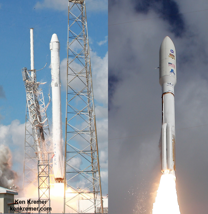
SpaceX and Boeing are building the private crew Dragon and CST-100 spaceships to resume launching US astronauts from US soil aboard Falcon 9 and Atlas V rockets (similar to these) to the International Space Station in 2017 - depending on funding from Congress. Credit:  Ken Kremer/kenkremer.com
SpaceX and Boeing are building the private crew Dragon and CST-100 spaceships to resume launching US astronauts from US soil aboard Falcon 9 and Atlas V rockets (similar to these) to the International Space Station in 2017 – depending on funding from Congress. Credit: Ken Kremer/kenkremer.com

Stay tuned here for Ken’s continuing Earth and planetary science and human spaceflight news.

Ken Kremer

Yummy! ISS Astronauts Eat First Space-Grown Food

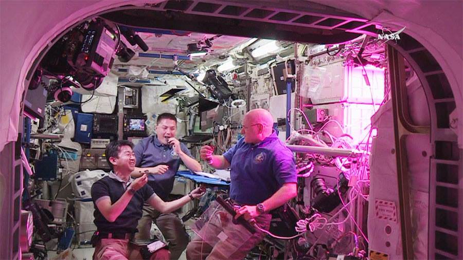
NASA Astronauts Kjell Lindgren (center) and Scott Kelly (right) and Kimiya Yui (left) of Japan consume space grown food for the first time ever, from the Veggie plant growth system on the International Space Station in August 2015. Credit: NASA TV

Video caption: That’s one small bite for a man, one giant leaf for mankind: NASA Astronauts Scott Kelly, Kjell Lindgren and Kimiya Yui of Japan sample the fruits of their labor after harvesting a crop of “Outredgeous” red romaine lettuce from the Veggie plant growth system on the International Space Station. Credit: NASA TV

Going where no astronauts have gone before, a trio of “space farmers” living aboard the International Space Station (ISS) have just become the first humans ever to eat food grown in space!

The gleeful munchers downed the freshly harvested crop of blood red colored “Outredgeous” red romaine lettuce salad during a live webcast today, Monday, August 10, direct from the Earth orbiting outpost soaring some 250 miles (400 km) above the home planet.

“Woo hoo ! …. Cheers!” exclaimed the eager Expedition 44 astronauts comprising Kjell Lindgren, Scott Kelly and Kimiya Yui, at the moment of truth, as they consumed the fruits of their own labor.

“It was one small bite for man, one giant leap for #NASAVEGGIE and our #JourneytoMars. #YearInSpace,” tweeted Kelly.

The momentous salad eating event took place at 12:26 EDT from beside the innovative and groundbreaking “Veggie” plant growth system, housed inside the European Space Agency’s Columbus laboratory located at the end of the US section of the ISS.

“That’s awesome!” said Lindgren with a broad smile – to the audible crunchy sounds of chewing on the freshly cut space lettuce.

“Tastes good!” replied Kelly, upon happily consuming the red leafed vegetable. He is now in the 5th month of his planned 1 Year mission aboard the ISS.

“Chomp! Our first veggies were harvested & consumed by astronauts in space!” tweeted NASA.

They all welcomed the opportunity to sample some freshly grown space produce from their miniature “ space farm.” Resident ISS crewmembers have been waiting for the “GO” to eat for some time.

“It tastes like arugula,” added Kelly, as they first tried the lettuce plain, as a control taste test of the virgin crop to get “the full effect.”

“It’s fresh,” Lindgren responded.

Then they doused quickly it with some oil and vinegar for flavor comparison.

“After trying the lettuce plain, @astro_kjell and @StationCDRKelly added oil & vinegar!” NASA tweeted.

Lindgren had carefully and methodically snipped away about half of the lettuce crop, on live NASA TV – which had grown to quite a size under the carefully maintained conditions inside “Veggie.”

He then cleaned “the leafy greens” by placing them between citric acid-based, food safe sanitizing wipes before the taste test.

After momentarily bagging the harvest, he distributed samples to his “tastemates” and the fun began.

“It’s wonderful to eat fresh food on the ISS, which is a lot of white and aluminum and it’s kind of a sterile environment,” said Kelly.

So this was quite different.

“It’s really fun to see green, growing things in here that we’re intentionally growing for sustenance. So we sure appreciate this payload and the opportunity to grow and eat and harvest these crops.”

The joyful trio saved some for the produce for their three Russian station colleagues to try later – Oleg Kononenko, Gennady Padalka and Mikhail Kornienko. Two of the Russian cosmonauts, Expedition 44 commander Padalka and Kelly’s 1 year crew mate Kornienko, were conducting a spacewalk today, simultaneously to the lettuce taste testing.

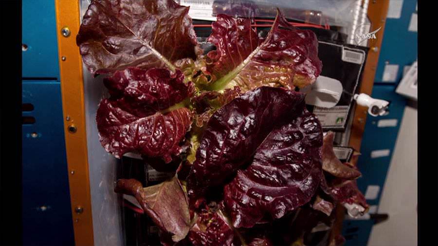
This "Outredgeous" red romaine lettuce was grown inside the Veggie plant growth system on the ISS and eaten on August 10, 2015 by the station crew.  The goal was to test hardware for growing vegetables and other plants to be harvested and eaten by astronauts in space.  Credits: NASA TV
This “Outredgeous” red romaine lettuce was grown inside the Veggie plant growth system on the ISS and eaten on August 10, 2015 by the station crew. The goal was to test hardware for growing vegetables and other plants to be harvested and eaten by astronauts in space. Credits: NASA TV

Another portion was set aside “to be packaged and frozen on the station until it can be returned to Earth for scientific analysis,” said NASA.

Although some vegetables have been grown before on the station, including prior crops of lettuce from “Veggie,” today marked the first time that any astronauts were “officially” granted “permission” to eat the fruits of their labor. Russian cosmonauts have eaten their station crops in the past. It’s a mystery whether any partner crewmates surreptitiously tasted some of the Russian produce.

And it not just for fun. In fact growing edible space food marks a significant new milestone towards enabling deep space human exploration, as explained by Kelly.

“Having lived on the space station for a while, I understand the logistical complexity of having people work in space for long periods and the supply chain that’s required to keep us going,” Kelly remarked.

“If we’re ever going to go to Mars someday, and we will, we’re going to have a spacecraft that is much more self sustainable with regard to its food supply.”

Experiments like these are critical for NASA’s plans to send humans on a “Journey to Mars” in the 2030s.

The “Journey to Mars” and back is likely to take well over two years and resupply is not possible. Crews will have to grow at least a portion of their own food and today’s experiment helps pave the human path to the Red Planet.

The “Veggie” experiment was developed by Orbital Technologies Corp. (ORBITEC) in Madison, Wisconsin.

The Veggie-01 apparatus was thoroughly tested at Kennedy before flight. It was delivered, along with two sets of pillows containing the romaine seeds and one set of zinnias, to the ISS by the SpaceX-3 Dragon cargo resupply mission launched in April 2014.

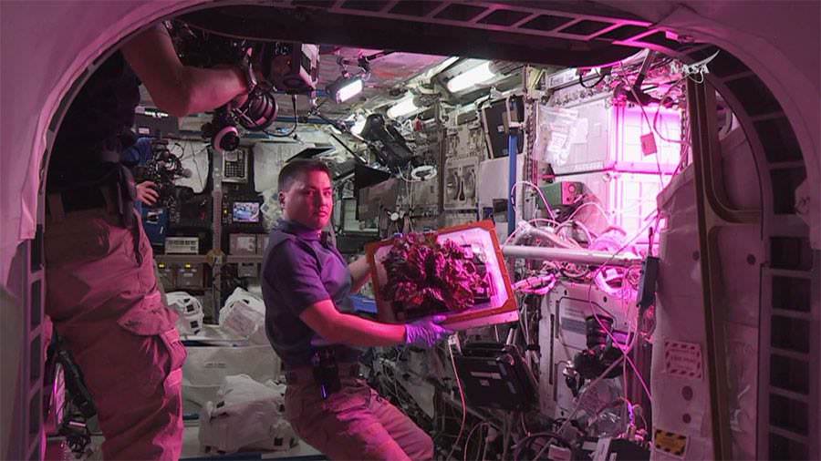
NASA astronaut Kjell Lindgren displays the  “Outredgeous" red romaine lettuce grown inside the Veggie plant growth system on the ISS prior to harvesting and consumption on August 10, 2015.  Credit: NASA TV
NASA astronaut Kjell Lindgren displays the “Outredgeous” red romaine lettuce grown inside the Veggie plant growth system on the ISS prior to harvesting and consumption on August 10, 2015. Credit: NASA TV

The lettuce crop inside the Veggie-01 plant pillows were activated by Kelly on July 8. They were grown for 33 days before being harvested today. The seeds had been stored dormant on the station for some 15 months since arriving aboard the SpaceX-3 Dragon, according to NASA.

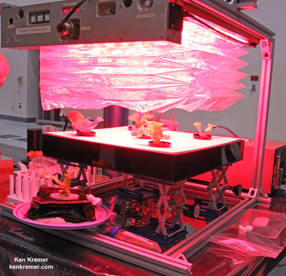
The collapsible and expandable Veggie unit features a flat panel light bank that includes red, blue and green LEDs for plant growth and crew observation.

Stay tuned here for Ken’s continuing Earth and planetary science and human spaceflight news.
Ken Kremer

Veggie demonstration apparatus growing red romaine lettuce under LED lights in the Space Station Processing Facility at NASA’s Kennedy Space Center.  Credit: Ken Kremer/kenkremer.com
Veggie demonstration apparatus growing red romaine lettuce under LED lights in the Space Station Processing Facility at NASA’s Kennedy Space Center. Credit: Ken Kremer/kenkremer.com

Mysterious Bright Spots and Pyramidal Mountain Star in Dawn’s Daunting Flyover of Ceres: Video

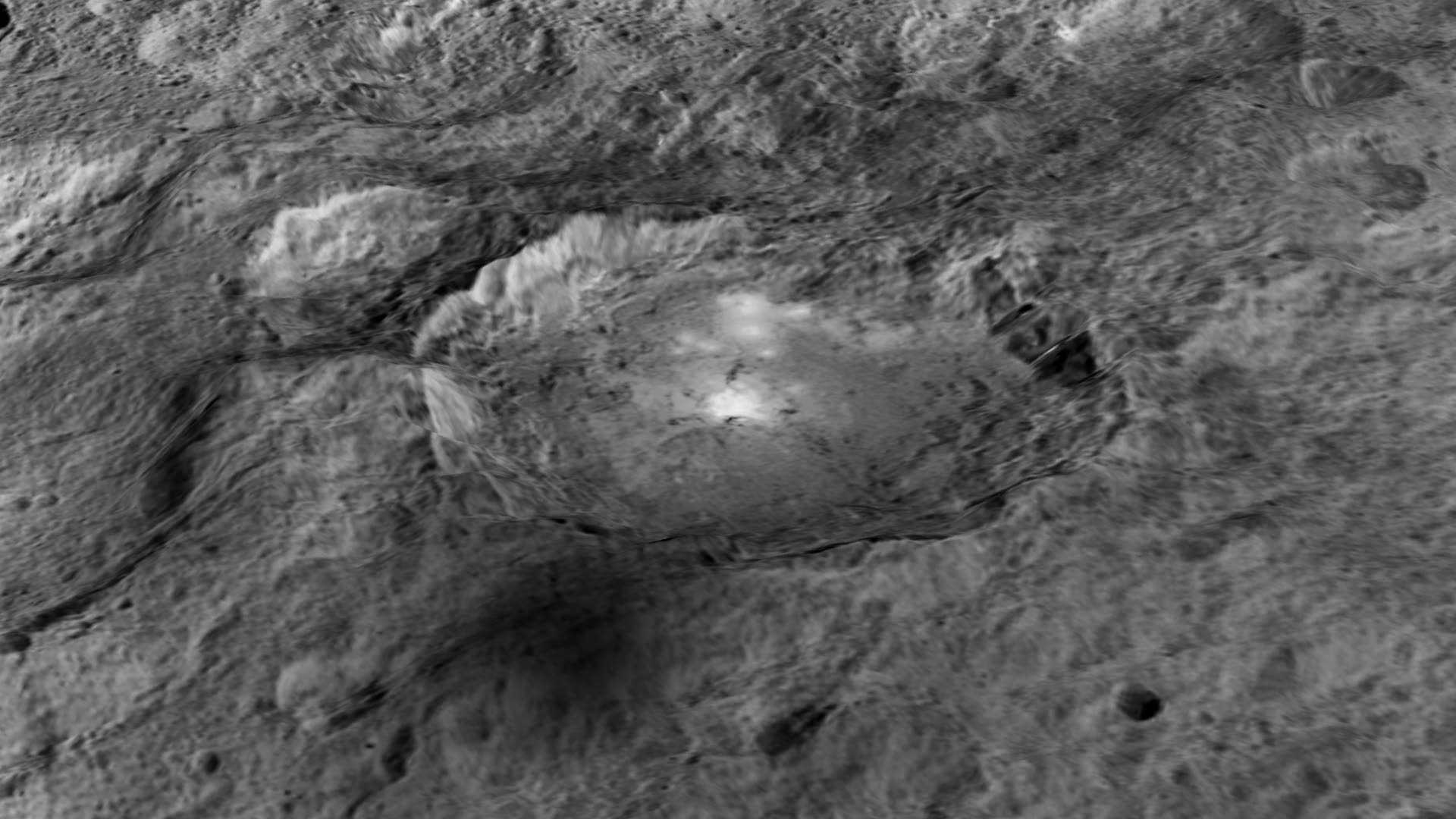
The intriguing brightest spots on Ceres lie in a crater named Occator, which is about 60 miles (90 kilometers) across and 2 miles (4 kilometers) deep. Vertical relief has been exaggerated by a factor of five. Exaggerating the relief helps scientists understand and visualize the topography much more easily, and highlights features that are sometimes subtle. Credits: NASA/JPL-Caltech/UCLA/MPS/DLR/IDA/LPI

Video caption: Take a tour of weird Ceres! Visit a 2-mile-deep crater and a 4-mile-tall mountain in the video narrated by mission director Marc Rayman. Get your red/blue glasses ready for the finale – a global view of the dwarf planet in 3D. Credits: NASA/JPL-Caltech/UCLA/MPS/DLR/IDA/LPI/PSI

Mysterious bright spots and a pyramidal shaped mountain star in a daunting new flyover video of dwarf planet Ceres created from imagery gathered by NASA’s history making Dawn mission – the first ever to visit any dwarf planet which simultaneously ranks as the largest world in the main asteroid belt residing between Mars and Jupiter.

Ceres was nothing more than a fuzzy blob to humankinds most powerful telescopes like the Hubble Space Telescope (HST), until the probe swooped in this year and achieved orbit on March 6, 2015.

The newly released, stunning video takes takes you on a tour like none before for a global cruise over the most fascinating features on Ceres – including the 2-mile-deep (4-km-deep) crater dubbed Occator and a towering 4-mile-tall (6 kilometer-tall) mountain as tall as any in North America.

The spectacular flyover animation was generated from high resolution images taken by Dawn’s framing camera during April and May and is narrated by Marc Rayman, Dawn Chief Engineer and Mission Director of NASA’s Jet Propulsion Laboratory, Pasadena, California.

The video concludes with a 3D view, so you’ll need to whip out your handy red/blue glasses for the finale – a global view of the dwarf planet in 3D.

From the orbital altitude at that time ranging from about 8,400 miles (13,600 kilometers) to 2,700 miles (4,400 kilometers), the highest-resolution regions on Ceres have a resolution of 1,600 feet (480 meters) per pixel.

Pockmarked Ceres is an alien world unlike any other in our solar system, replete with unexplained bright spots and craters of many sizes, large and small.

Occatur has captured popular fascination world-wide because the 60 miles (90 kilometers) diameter crater is rife with a host of the bodies brightest spots and whose nature remains elusive to this day, nearly half a year after Dawn arrived in orbit this past spring.

“Now, after a journey of 3.1 billion miles (4.9 billion kilometers) and 7.5 years, Dawn calls Ceres, home,” says Rayman.

The crater is named after the Roman agriculture deity of harrowing, a method of pulverizing and smoothing soil.

Dawn is an international science mission managed by NASA and equipped with a trio of science instruments from the US, Germany and Italy. The framing camera was provided by the Max Planck Institute for Solar System Research, Göttingen, Germany and the German Aerospace Center (DLR).

The visible and infrared mapping spectrometer (VIR), provided by Italy is an imaging spectrometer that examines Ceres in visible and infrared light.

Dawn’s science team is using the instruments to investigate the light reflecting from Occator at different wavelengths.

From a distance, the crater appeared to be home to a duo of bright spots that looked like a pair of eyes. As Dawn moves ever closer, they became more resolved and now are split into dozens of smaller bright spots.

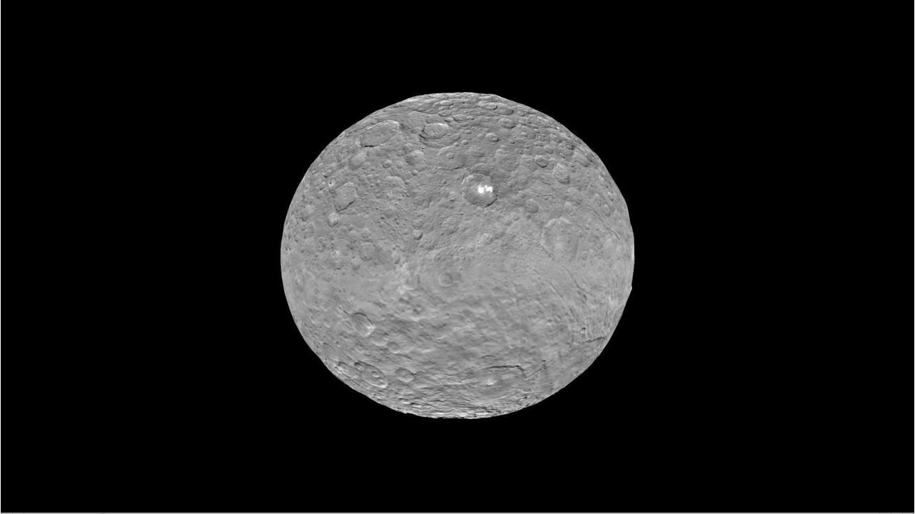
Global view of Ceres uses data collected by NASA's Dawn mission in April and May 2015.  The highest-resolution parts of the map have a resolution of 1,600 feet (480 meters) per pixel.  Credits: NASA/JPL-Caltech/UCLA/MPS/DLR/IDA/LPI/PSI
Global view of Ceres uses data collected by NASA’s Dawn mission in April and May 2015. The highest-resolution parts of the map have a resolution of 1,600 feet (480 meters) per pixel. Credits: NASA/JPL-Caltech/UCLA/MPS/DLR/IDA/LPI/PSI

Although some early speculation centered on the spots possibly being consistent with water ice or salts, newly gathered data “has not found evidence that is consistent with ice. The spots’ albedo -¬ a measure of the amount of light reflected -¬ is also lower than predictions for concentrations of ice at the surface,” according to the scientists.

“The science team is continuing to evaluate the data and discuss theories about these bright spots at Occator,” said Chris Russell, Dawn’s principal investigator at the University of California, Los Angeles, in a statement.

“We are now comparing the spots with the reflective properties of salt, but we are still puzzled by their source. We look forward to new, higher-resolution data from the mission’s next orbital phase.”
Occator lies in Ceres northern hemisphere.

The huge pyramidal mountain lies farther to the southeast of Occator – at 11 degrees south, 316 degrees east.

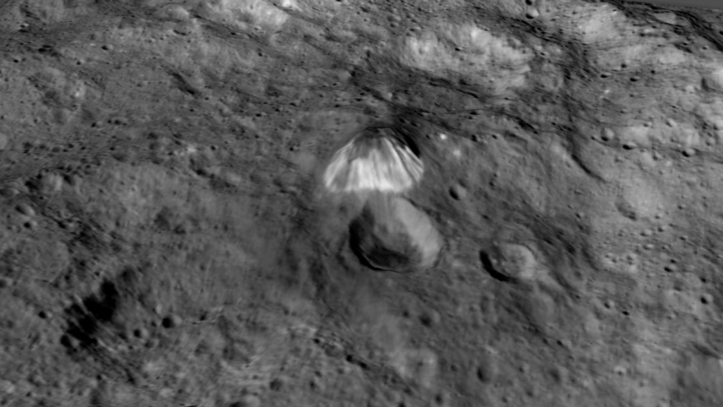
Based on the latest calculations, the mountain sits about 4 miles (6 kilometers) high, with respect to the surface around it. That make it roughly the same elevation as Mount McKinley in Denali National Park, Alaska, the highest point in North America.

Among the highest features seen on Ceres so far is a mountain about 4 miles (6 kilometers) high, which is roughly the elevation of Mount McKinley in Alaska's Denali National Park.  Vertical relief has been exaggerated by a factor of five to help understand the topography. Credits: NASA/JPL-Caltech/UCLA/MPS/DLR/IDA/LPI
Among the highest features seen on Ceres so far is a mountain about 4 miles (6 kilometers) high, which is roughly the elevation of Mount McKinley in Alaska’s Denali National Park. Vertical relief has been exaggerated by a factor of five to help understand the topography. Credits: NASA/JPL-Caltech/UCLA/MPS/DLR/IDA/LPI

The Texas-sized world is slightly smaller than previously thought. Based on new measurements from Dawn, Ceres’ average diameter to 584 miles (940 kilometers), compared to earlier estimates of 590 miles (950 kilometers).

Dawn made history in March when it simultaneously became the first probe from Earth to reach Ceres as well as the first spacecraft to orbit two extraterrestrial bodies.

It had previously visited Vesta. After achieving orbit in July 2011, Dawn became the first spacecraft from Earth to orbit a body in the main Asteroid Belt.

In sharp contrast to rocky Vesta, Ceres is an icy world.

Scientists believe that Ceres may harbor an ocean of subsurface liquid water as large in volume as the oceans of Earth below a thick icy mantle despite its small size – and thus could be a potential abode for life. Overall Ceres is estimated to be about 25% water by mass.

“We really appreciate the interest in our mission and hope they are as excited as we have been about these scientific surprises,” Russell told Universe Today.

“Since we are only just beginning our investigation, I expect that there will be more surprises. So please stick with us!”

As Dawn spirals down to a lower orbit of about 1,200 miles (1,900 km) above Ceres (and then even lower) using its ion engines, new answers and new mysteries are sure to be forthcoming.

“There are many other features that we are interested in studying further,” said Dawn science team member David O’Brien, with the Planetary Science Institute, Tucson, Arizona.

“These include a pair of large impact basins called Urvara and Yalode in the southern hemisphere, which have numerous cracks extending away from them, and the large impact basin Kerwan, whose center is just south of the equator.”

The mission is expected to last until at least June 2016 depending upon fuel reserves.

Dawn was launched on September 27, 2007 by a United Launch Alliance (ULA) Delta II Heavy rocket from Space Launch Complex-17B (SLC-17B) at Cape Canaveral Air Force Station, Florida.

Stay tuned here for Ken’s continuing Earth and planetary science and human spaceflight news.

Ken Kremer

Moon Transits Earth in Eye-poppingly EPIC View from 1 Million Miles Away

This animation shows images of the far side of the moon, illuminated by the sun, as it crosses between the DISCOVR spacecraft's Earth Polychromatic Imaging Camera (EPIC) camera and telescope, and the Earth - one million miles away. Credit: NASA/NOAA

This animation shows images of the far side of the moon, illuminated by the sun, as it crosses between the DISCOVR spacecraft’s Earth Polychromatic Imaging Camera (EPIC) camera and telescope, and the Earth – one million miles away. Credit: NASA/NOAA
See YouTube version and EPIC camera below[/caption]

An eye-poppingly ‘EPIC’ view of the sunlit far side of the Moon transiting the sunlit side of Earth was recently captured by NASA’s Earth Polychromatic Imaging Camera (EPIC) camera from one million miles away. “Wow!” – is an understatement!

The stunning animation of the Moon crossing in front of the Earth, shown above, and seemingly unlike anything else, was created from a series of images taken in July by NASA’s EPIC camera flying aboard the orbiting Deep Space Climate Observatory (DSCOVR), a space weather monitoring satellite, according to a NASA statement.

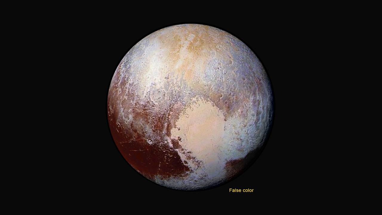
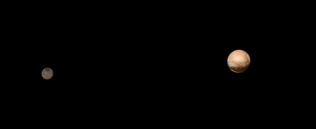
Have just witnessed NASA’s New Horizons flyby of the Pluto-Charon double planet system, the similarity to what some call the Earth-Moon double planet system is eerie. You could imagine ones heart going out to Earth’s Australian continent as an upside down version of Pluto’s bright heart shaped ‘Tombaugh Regio’ region in the southern hemisphere.

EPIC is a four megapixel CCD camera and telescope mounted on DSCOVR and orbiting at the L1 Lagrange Point – a neutral gravity point that lies on the direct line between Earth and the sun.

The goal of the $340 million DSCOVR is to monitor the solar wind and aid very important forecasts of space weather at Earth from L1.

EPIC will capture “a constant view of the fully illuminated Earth as it rotates, providing scientific observations of ozone, vegetation, cloud height and aerosols in the atmosphere.”

L1 is located 1.5 million kilometers (932,000 miles) sunward from Earth. At L1 the gravity between the sun and Earth is perfectly balanced and the DSCOVR satellite orbits about that spot just like a planet.

The EPIC images “were taken between 3:50 p.m. and 8:45 p.m. EDT on July 16, showing the moon moving over the Pacific Ocean near North America,” NASA said.

This image shows images of the far side of the moon, illuminated by the sun, as it crosses between the DISCOVR spacecraft's Earth Polychromatic Imaging Camera (EPIC) camera and telescope, and the Earth - one million miles away.  Credits: NASA/NOAA
This image shows images of the far side of the moon, illuminated by the sun, as it crosses between the DISCOVR spacecraft’s Earth Polychromatic Imaging Camera (EPIC) camera and telescope, and the Earth – one million miles away. Credits: NASA/NOAA

You can see Earth’s North Pole at the upper left side of the images which results from the orbital tilt of Earth from the vantage point of the spacecraft at the L1 Lagrange Point.

EPIC will take full disk color images of the sunlit side of Earth at least six times per day.

They will be made publically available by NASA at a dedicated website, when the camera starts its regular daily science observation campaign of the home planet in about a month during September.

NASA says the images will show varying views of the rotating Earth and they will be posted online some 12 to 36 hours after they are acquired.

Each image is actually a composite of three images taken in the red, green and blue channels of the EPIC camera to provide the final “natural color” image of Earth. Since the images are taken about 30 seconds apart as the moon is moving there is a slight but noticeable artifact on the right side of the moon, NASA explained.

Altogether, “ EPIC takes a series of 10 images using different narrowband spectral filters — from ultraviolet to near infrared — to produce a variety of science products. The red, green and blue channel images are used in these color images.”

EPIC should capture these Earth-Moon transits about twice per year as the orbit of DSCOVR crosses the orbital plane of the moon.

The closest analog according to NASA came in May 2008 when NASA’s Deep Impact spacecraft “captured a similar view of Earth and the moon from a distance of 31 million miles away. The series of images showed the moon passing in front of our home planet when it was only partially illuminated by the sun.”

We never see the far side of the moon from Earth since the bodies are tidally locked. And its quite apparent from the images, that the moon’s far side looks completely different from the side facing Earth. The far side lacks the large, dark, basaltic plains, or maria, that are so prominent on the Earth-facing side.

“It is surprising how much brighter Earth is than the moon,” said Adam Szabo, DSCOVR project scientist at NASA’s Goddard Space Flight Center in Greenbelt, Maryland, in a statement.

“Our planet is a truly brilliant object in dark space compared to the lunar surface.”

DSCOVR is a joint mission between NOAA, NASA, and the U.S Air Force (USAF) that is managed by NOAA. The satellite and science instruments were provided by NASA and NOAA.

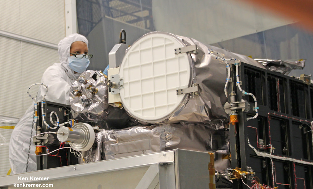
Technician works on NASA Earth science instruments and Earth imaging EPIC camera (white circle) housed on NOAA/NASA Deep Space Climate Observatory (DSCOVR) inside NASA Goddard Space Flight Center clean room in November 2014.  Credit: Ken Kremer/kenkremer.com/AmericaSpace
Technician works on NASA Earth science instruments and Earth imaging EPIC camera (white circle) housed on NOAA/NASA Deep Space Climate Observatory (DSCOVR) inside NASA Goddard Space Flight Center clean room in November 2014. Credit: Ken Kremer/kenkremer.com

The couch sized probe was launched atop a SpaceX Falcon 9 on Feb. 11, 2015 from Cape Canaveral, Florida, to start a million mile journey to its deep space observation post. The rocket was funded by the USAF.

DSCOVR was first proposed in 1998 by then US Vice President Al Gore as the low cost ‘Triana’ satellite to take near continuous views of the Earth’s entire globe to feed to the internet as a means of motivating students to study math and science. It was eventually built as a much more capable Earth science satellite that would also conduct the space weather observations.

But Triana was shelved for purely partisan political reasons and the satellite was placed into storage at NASA Goddard and the science was lost until now.

It was also dubbed “Goresat.’

Stay tuned here for Ken’s continuing Earth and planetary science and human spaceflight news.

Ken Kremer

Video caption: This animation shows images of the far side of the moon, illuminated by the sun, as it crosses between the DISCOVR spacecraft’s Earth Polychromatic Imaging Camera (EPIC) camera and telescope, and the Earth – one million miles away. Credit: NASA/NOAA

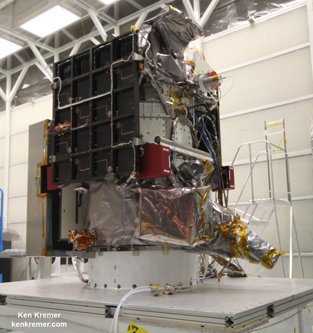
NOAA/NASA Deep Space Climate Observatory (DSCOVR) undergoes processing in NASA Goddard Space Flight Center clean room. Solar wind instruments at right. DSCOVER will launch in February 2015 atop SpaceX Falcon 9 rocket.  Credit: Ken Kremer/kenkremer.com/AmericaSpace
NOAA/NASA Deep Space Climate Observatory (DSCOVR) undergoes processing in NASA Goddard Space Flight Center clean room. Solar wind instruments at right. DSCOVER launched in February 2015 atop SpaceX Falcon 9 rocket. Credit: Ken Kremer/kenkremer.com
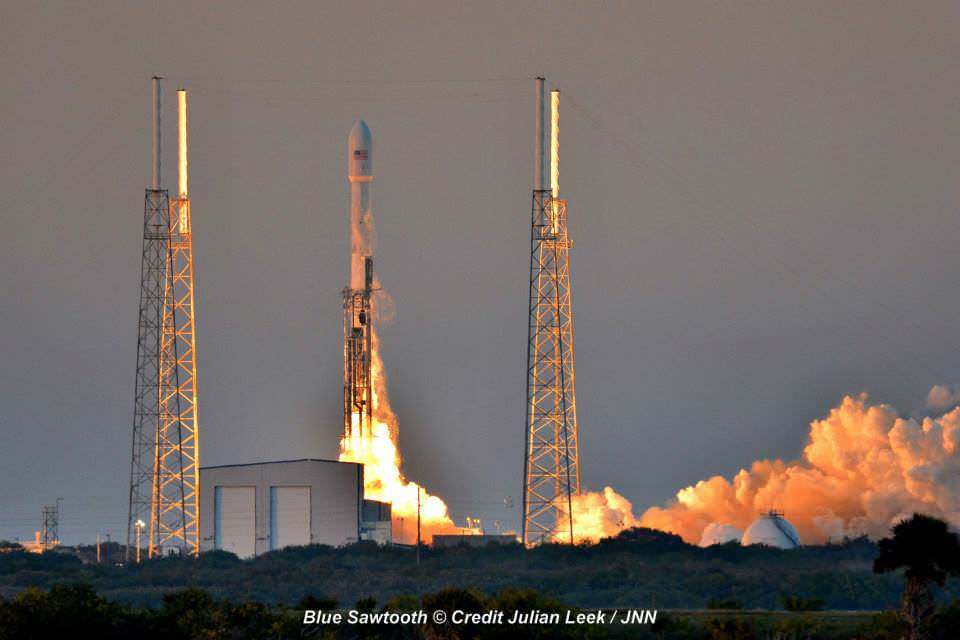
Launch of NOAA DSCOVR satellite from Cape Canaveral Air Force Station on Feb. 11, 2015 to monitor solar storms and space weather.   Credit:  Julian Leek
Launch of NOAA DSCOVR satellite from Cape Canaveral Air Force Station on Feb. 11, 2015 to monitor solar storms and space weather. Credit: Julian Leek

Curiosity Drills Deep into First High Silica Martian Rock on Third Touchdown Anniversary

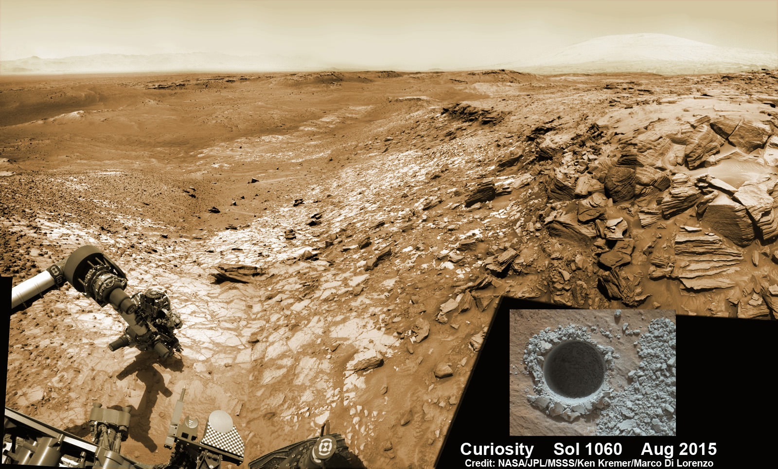
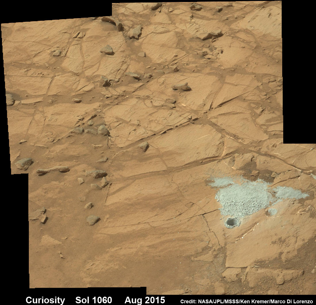
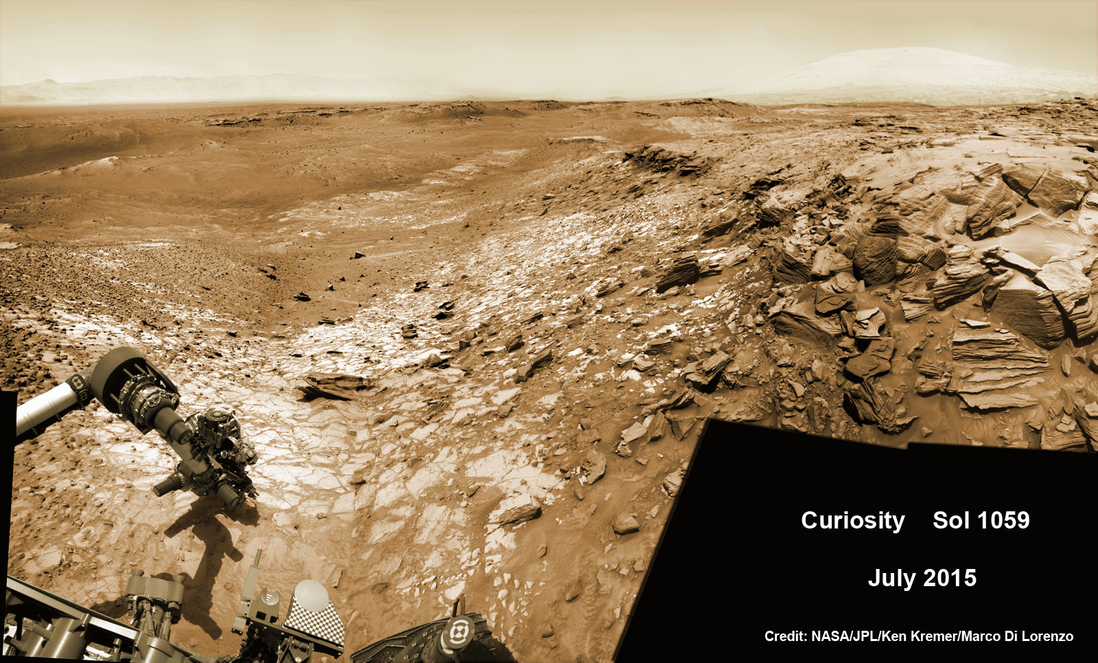
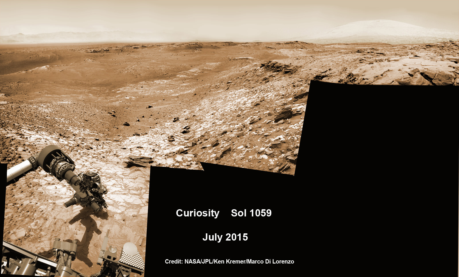
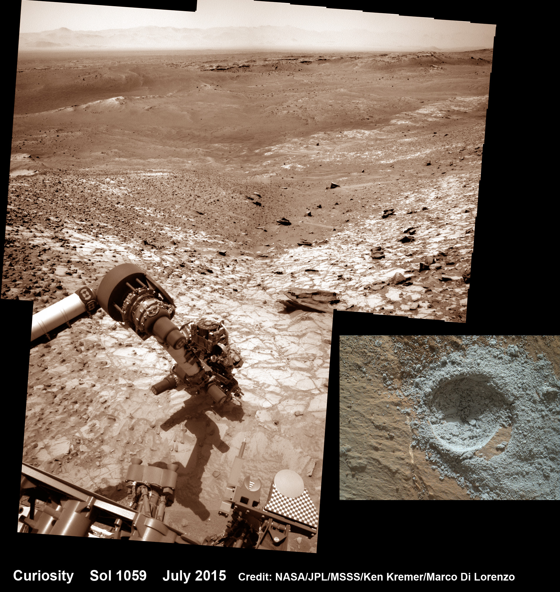
Curiosity extends robotic arm and conducts sample drilling at “Buckskin” rock target at bright toned “Lion” outcrop at the base of Mount Sharp on Mars, seen at right. Gale Crater eroded rim seen in the distant background at left, in this composite multisol mosaic of navcam raw images taken to Sol 1059, July 30, 2015. Navcam camera raw images stitched and colorized. Inset: MAHLI color camera up close image of full depth drill hole at “Buckskin” rock target on Sol 1060. Credit: NASA/JPL-Caltech/MSSS/Ken Kremer/kenkremer.com/Marco Di Lorenzo

Curiosity extends robotic arm and conducts sample drilling at “Buckskin” rock target at bright toned “Lion” outcrop at the base of Mount Sharp on Mars, seen at right, during August 2015. Gale Crater eroded rim seen in the distant background at left, in this composite multisol mosaic of navcam raw images taken to Sol 1059, July 30, 2015. Navcam camera raw images stitched and colorized. Inset: MAHLI color camera up close image of full depth drill hole at “Buckskin” rock target on Sol 1060. Credit: NASA/JPL-Caltech/MSSS/Ken Kremer/kenkremer.com/Marco Di Lorenzo
Story updated[/caption]

NASA’s Curiosity Mars Science Laboratory (MSL) rover has successfully drilled into the first high silica rock target on Mars after recently discovering this new type of rock that’s unlike any found before – as she is about to mark the 3rd anniversary since the hair-raising touchdown on the Red Planet.

The SUV-sized rover bored a full depth hole into a Mars outcrop at a target dubbed “Buckskin” as commanded by the mission team over the weekend, after first conducting a mini drill test to assess the safety of the intended drill campaign to sample the alien rock interior beneath the Martian crater floor.

“This morning, the MSL operations team was very happy to see that drilling into Buckskin was successful!” said Ken Herkenhoff, Research Geologist at the USGS Astrogeology Science Center and an MSL science team member, in a mission update.

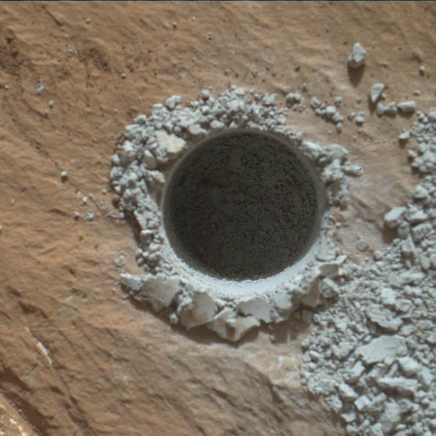
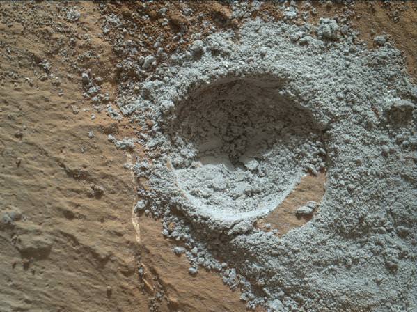
Confirmation of the success of the full depth drilling into “Buckskin” on Sol 1060 at the bright toned “Lion” outcrop came later after receipt of new high resolution images from the rover showing the approximately 1.6 cm (0.63 inch) diameter bore hole next to the initial mini hole test, along with the indicative residue of grey colored tailings from the Martian subsurface seen distributed around the new hole.

“Successful drilling at Buckskin!” added team member Professor John Bridges of the University of Leicester, England, in an update.

“Like the other drill holes this is showing how thin red Mars is,” Bridges elaborated.

Beneath a thin veneer of rusty red colored iron oxide, the Red Planet is remarkably grey as demonstrated by Curiosity’s prior drilling campaigns.

The hole was bored to a full depth of about 2.6 inches (6.5 centimeters) using the percussion drill on the terminus of the 7 foot-long (2.1 meter-long) robotic arm.

Curiosity rover successfully drills into Martian outcrop  at Buckskin rock target at current work site at base of Mount Sharp in August 2015, in this mosaic showing full depth drill hole and initial test hole, with grey colored subsurface tailings and mineral veins on surrounding Red Planet terrain.  This high resolution photo mosaic is a multisol composite of color images taken by the mast mounted Mastcam-100 color camera up to Sol 1060, July 31, 2015.   Credit:  NASA/JPL-Caltech/Ken Kremer/kenkremer.com/Marco Di Lorenzo
Curiosity rover successfully drills into Martian outcrop at Buckskin rock target at current work site at base of Mount Sharp in August 2015, in this mosaic showing full depth drill hole and initial test hole, with grey colored subsurface tailings and mineral veins on surrounding Red Planet terrain. This high resolution photo mosaic is a multisol composite of color images taken by the mast mounted Mastcam-100 color camera up to Sol 1060, July 31, 2015. Credit: NASA/JPL-Caltech/Ken Kremer/kenkremer.com/Marco Di Lorenzo

Buckskin was “chosen because this sedimentary horizon has some very high silica enrichments,” Bridges explains.

The findings of elevated levels of silicon as well as hydrogen were derived from data collected by Curiosity’s laser-firing Chemistry & Camera (ChemCam) and Dynamic Albedo of Neutrons (DAN) instruments on certain local area rocks.

Silica is a rock-forming compound containing silicon and oxygen, commonly found on Earth as quartz.

“High levels of silica could indicate ideal conditions for preserving ancient organic material, if present, so the science team wants to take a closer look,” say mission team officials.

See the rover at work reaching out with her robotic arm and drilling into Buckskin, as illustrated in our new mosaics of mastcam and navcam camera raw images created by the image processing team of Ken Kremer and Marco Di Lorenzo (above and below).

“Buckskin” sits at the base of Mount Sharp, a huge layered mountain that dominates the center of the 96 mile-wide (154 kilometers-wide) Gale Crater landing site.

Exploring the sedimentary layers of Mount Sharp, which towers 3.4 miles (5.5 kilometers) into the Martian sky, is the primary destination and goal of the rovers long term scientific expedition on the Red Planet.

The silica enrichment “may have occurred as the Gale sediments were altered by subsurface fluids after burial. As the basaltic composition was altered (as we saw from the clay and Fe oxide at Yellowknife Bay) ultimately a lot of silica is released which can be precipitated at horizons like this,” explains Bridges.

The Curiosity Mars Science Laboratory (MSL) rover safely touched down on the crater floor on August 5, 2012 following the unprecedented and nail-biting sky crane maneuver that delivered her with pinpoint precision to a landing site nearby Mount Sharp inside Gale Crater.

The goal of the drilling is to provide geologic context for Curiosity’s long term climb up the mountains sedimentary layers by collecting samples to assess the habitability of the Red Planet over billions of years of time.

So the plan was for the robot to process and pulverize the samples for eventual delivery to the onboard pair of miniaturized chemistry labs located inside her belly – SAM and CheMin. Tiny samples are fed to a trio of inlet ports on the rover deck through the sieved filters.

Images are taken to document and assess the entire sample collection and delivery process.

After gathering the Buckskin sample, a portion was transferred to the robots scoop for inspection.

Then the first portion was successfully fed into CheMin for inorganic elemental analysis over the weekend.

“The activities planned for last weekend completed successfully, including sample dropoff to CheMin and analysis of the minerals present,” Herkenhoff confirmed.

The one ton robots next steps involve “dumping the portion of the drill sample that has not been sieved and Mastcam, ChemCam, MAHLI, and APXS observations of the dump pile. ChemCam and Mastcam will also observe nearby targets “Martz” and “Mountain Home.” MAHLI will image the drill hole, tailings and CheMin inlet at night using its LEDs for illumination.”

Curiosity MAHLI camera image taken of Buckskin drill hole on Sol 1060 on July 31, 2015. Credit: NASA/JPL/MSSS

After completing these science activities, the six wheeled rover will move on to the next exciting destination.

“It’s been a great couple of weeks at the Lion outcrop, but it’s time to move on,” says Lauren Edgar, Research Geologist at the USGS Astrogeology Science Center and an MSL science team member, in the latest mission update from today, August 4, Sol 1065.

“After a successful investigation that included observations by almost every science instrument, we’re getting ready to drive away tomorrow. That means that today (and tomorrow before we drive) is the last call for science observations.”

For about the past two months, the six wheeled robot has been driving around and exploring a geological contact zone named “Marias Pass” – an area on lower Mount Sharp, by examining the rocks and outcrops with her suite of state-of-the-art science instruments.

“Marias Pass” is a geological context zone where two rock types overlap – pale mudstone meets darker sandstone.

The prior hole was drilled at Telegraph Peak on Feb. 24, 2015, on Sol 908.

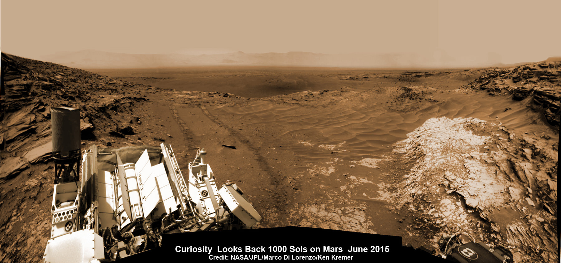
Curiosity recently celebrated 1000 Sols of exploration on Mars on May 31, 2015 – detailed here with our Sol 1000 mosaic also featured at Astronomy Picture of the Day on June 13, 2015.

NASA’s Martian Curiosity rover looks backs to 1000 Sols of science and exploration on the surface of the Red Planet.  Robot wheel tracks lead back through valley dunes.  Gale Crater rim seen in the distant hazy background.  Sol 997 (May 28, 2015) navcam camera raw images stitched and colorized. Credit:  NASA/JPL-Caltech/ Marco Di Lorenzo/Ken Kremer/kenkremer.com Featured on APOD on June 13, 2015
NASA’s Martian Curiosity rover looks backs to 1000 Sols of science and exploration on the surface of the Red Planet. Robot wheel tracks lead back through valley dunes. Gale Crater rim seen in the distant hazy background. Sol 997 (May 28, 2015) navcam camera raw images stitched and colorized. Credit: NASA/JPL-Caltech/ Marco Di Lorenzo/Ken Kremer/kenkremer.com
Featured on APOD on June 13, 2015

As of today, Sol 1065, August 4, 2015, she has driven some 11 kilometers and taken over 256,000 amazing images.

Curiosity has already accomplished her primary objective of discovering a habitable zone on the Red Planet – at the Yellowknife Bay area – that contains the minerals necessary to support microbial life in the ancient past when Mars was far wetter and warmer billions of years ago.

Stay tuned here for Ken’s continuing Earth and planetary science and human spaceflight news.

Ken Kremer

Curiosity extends robotic arm and conducts test drill at “Buckskin” rock target at bright toned “Lion” outcrop on the lower region of Mount Sharp on Mars, seen at right.   Gale Crater eroded rim seen in the distant background at left, in this composite multisol mosaic of navcam raw images taken to Sol 1059, July 30, 2015.  Navcam camera raw images stitched and colorized. Credit:  NASA/JPL-Caltech/Ken Kremer/kenkremer.com/Marco Di Lorenzo
Curiosity extends robotic arm and conducts test drill at “Buckskin” rock target at bright toned “Lion” outcrop on the lower region of Mount Sharp on Mars, seen at right. Gale Crater eroded rim seen in the distant background at left, in this composite multisol mosaic of navcam raw images taken to Sol 1059, July 30, 2015. Navcam camera raw images stitched and colorized. Credit: NASA/JPL-Caltech/Ken Kremer/kenkremer.com/Marco Di Lorenzo

Curiosity Discovers Mars Rock Like None Before, Sets Drill Campaign

Curiosity extends robotic arm and conducts test drill at “Buckskin” rock target at bright toned “Lion” outcrop on the lower region of Mount Sharp on Mars, seen at right. Gale Crater eroded rim seen in the distant background at left, in this composite multisol mosaic of navcam raw images taken to Sol 1059, July 30, 2015. Navcam camera raw images stitched and colorized. Credit: NASA/JPL-Caltech/Ken Kremer/kenkremer.com/Marco Di Lorenzo

On the eve of the 3rd anniversary since her nail biting touchdown inside Gale Crater, NASA’s car sized Curiosity Mars Science Laboratory (MSL) rover has discovered a new type of Martian rock that’s surprisingly rich in silica – and unlike any other targets found before.

Excited by this new science finding on Mars, Curiosity’s handlers are now gearing the robot up for her next full drill campaign today, July 31 (Sol 1060) into a rock target called “Buckskin” – which lies at the base of Mount Sharp, the huge layered mountain that is the primary science target of this Mars rover mission.

“The team selected the “Buckskin” target to drill,” says Lauren Edgar, Research Geologist at the USGS Astrogeology Science Center and an MSL science team member, in a mission update.

“It’s another exciting day on Mars!”

See the rover at work reaching out with her robotic arm and drilling into Buckskin, as illustrated in our new mosaics of navcam camera images created by the image processing team of Ken Kremer and Marco Di Lorenzo (above and below). Also featured at Alive Universe Images – here.

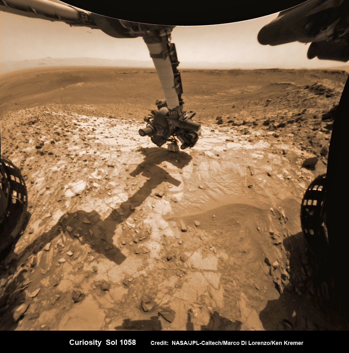
NASA Curiosity rover inspects ‘Buckskin’ rock outcrop on Mars with APXS mineral spectrometer in this hazcam camera raw image taken on July 29, 2015 (Sol 1058), colorized and linearized.  Credit:  NASA/JPL-Caltech/Marco Di Lorenzo/Ken Kremer/kenkremer.com
NASA Curiosity rover inspects ‘Buckskin’ rock outcrop on Mars with APXS mineral spectrometer in this hazcam camera raw image taken on July 29, 2015 (Sol 1058), colorized and linearized. Credit: NASA/JPL-Caltech/Marco Di Lorenzo/Ken Kremer/kenkremer.com

For about the past two months, the six wheeled robot has been driving around and exploring a geological contact zone named “Marias Pass” – an area on lower Mount Sharp, by examining the rocks and outcrops with her suite of state-of-the-art science instruments.

The goal is to provide geologic context for her long term expedition up the mountains sedimentary layers to study the habitability of the Red Planet over eons of time.

Data from Curiosity’s “laser-firing Chemistry & Camera (ChemCam) and Dynamic Albedo of Neutrons (DAN), show elevated amounts of silicon and hydrogen, respectively,” in certain local area rocks, according to the team.

Silica is a rock-forming compound containing silicon and oxygen, commonly found on Earth as quartz.

“High levels of silica could indicate ideal conditions for preserving ancient organic material, if present, so the science team wants to take a closer look.”

Curiosity conducts test drill at “Buckskin” rock target at bright toned “Lion” outcrop on the lower region of Mount Sharp on Mars.   Gale crater rim seen in the distant background, in this composite mosaic of navcam raw images taken to Sol 1059, July 30, 2015.  Navcam camera raw images stitched and colorized. Credit:  NASA/JPL-Caltech/Ken Kremer/kenkremer.com/Marco Di Lorenzo  Inset: MAHLI camera up close image of  test drill at “Buckskin” rock target.  Credit: NASA/JPL-Caltech/MSSS
Curiosity extends robotic arm and conducts test drill at “Buckskin” rock target at bright toned “Lion” outcrop on the lower region of Mount Sharp on Mars. Gale crater rim seen in the distant background, in this composite mosaic of navcam raw images taken to Sol 1059, July 30, 2015. Inset: MAHLI camera up close image of test drill at “Buckskin” rock target. Navcam camera raw images stitched and colorized. Credit: NASA/JPL-Caltech/Ken Kremer/kenkremer.com/Marco Di Lorenzo Credit: NASA/JPL-Caltech/MSSS

Therefore the team scouted targets suitable for in depth analysis and sample drilling and chose “Buckskin”.

“Buckskin” is located among some high-silica and hydrogen enriched targets at a bright outcrop named “Lion.”

An initial test bore operation was conducted first to confirm whether that it was indeed safe to drill into “Buckskin” and cause no harm to the rover before committing to the entire operation.

The bore hole is about 1.6 cm (0.63 inch) in diameter.

“This test will drill a small hole in the rock to help determine whether it is safe to go ahead with the full hole,” elaborated Ryan Anderson, planetary scientist at the USGS Astrogeology Science Center and an MSL science team member.

So it was only after the team received back new high resolution imagery last night from the arm-mounted MAHLI camera which confirmed the success of the mini-drill operation, that the “GO” was given for a full depth drill campaign. MAHLI is short for Mars Hand Lens Imager.

“We successfully completed a mini drilling test yesterday (shown in the MAHLI image). That means that today we’re going for the FULL drill hole” Edgar confirmed.

“GO for Drilling.”

So it’s a busy day ahead on the Red Planet, including lots of imaging along the way to document and confirm that the drilling operation proceeds safely and as planned.

“First we’ll acquire MAHLI images of the intended drill site, then we’ll drill, and then we’ll acquire more MAHLI images after drilling,” Edgar explains.

“The plan also includes Navcam imaging of the workspace, and Mastcam imaging of the target and drill bit. In addition to drilling, we’re getting CheMin ready to receive sample in an upcoming plan. Fingers crossed!” Surface observations with the arm-mounted Alpha Particle X-ray Spectrometer (APXS) instrument are also planned.

If all goes well, the robot will process and pulverize the samples for eventual delivery to the onboard pair of miniaturized chemistry labs located inside her belly – SAM and CheMin. Tiny samples will be fed to the inlet ports on the rover deck through the sieved filters.

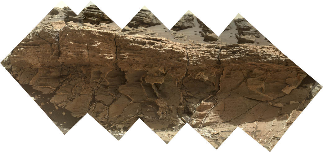
A rock outcrop dubbed "Missoula," near Marias Pass on Mars, is seen in this image mosaic taken by the Mars Hand Lens Imager on NASA's Curiosity rover. Pale mudstone (bottom of outcrop) meets coarser sandstone (top) in this geological contact zone, which has piqued the interest of Mars scientists.   Credit: NASA/JPL-Caltech/MSSS
A rock outcrop dubbed “Missoula,” near Marias Pass on Mars, is seen in this image mosaic taken by the Mars Hand Lens Imager on NASA’s Curiosity rover. Pale mudstone (bottom of outcrop) meets coarser sandstone (top) in this geological contact zone, which has piqued the interest of Mars scientists. Credit: NASA/JPL-Caltech/MSSS

Meanwhile the team is studying a nearby rock outcrop called “Ch-paa-qn” which means “shining peak” in the native Salish language of northern Montana.”

Anderson says the target is a bright patch on a nearby outcrop. Via active and passive observations with the mast-mounted ChemCam laser and Mastcam multispectral imager, the purpose is to determine if “Ch-paa-qn” is comprised of calcium sulfate like other white veins visible nearby, or perhaps it’s something else entirely.

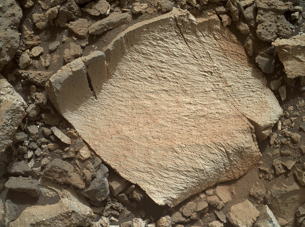
A rock fragment dubbed "Lamoose" is shown in this picture taken by the Mars Hand Lens Imager (MAHLI) on NASA's Curiosity rover. Like other nearby rocks in a portion of the "Marias Pass" area of Mt. Sharp, Mars, it has unusually high concentrations of silica. The high silica was first detected in the area by the Chemistry & Camera (ChemCam) laser spectrometer. This rock was targeted for follow-up study by the MAHLI and the arm-mounted Alpha Particle X-ray Spectrometer (APXS).  Credits: NASA/JPL-Caltech/MSSS
A rock fragment dubbed “Lamoose” is shown in this picture taken by the Mars Hand Lens Imager (MAHLI) on NASA’s Curiosity rover. Like other nearby rocks in a portion of the “Marias Pass” area of Mt. Sharp, Mars, it has unusually high concentrations of silica. The high silica was first detected in the area by the Chemistry & Camera (ChemCam) laser spectrometer. This rock was targeted for follow-up study by the MAHLI and the arm-mounted Alpha Particle X-ray Spectrometer (APXS). Credits: NASA/JPL-Caltech/MSSS

Before arriving by the “Lion” outcrop last week, Curiosity was investigating another outcrop area nearby, the high-silica target dubbed “Elk” with the ChemCam instrument, while scouting around the “Marias Pass” area in search of tasty science targets for in-depth analysis.

Sometimes the data subsequently returned and analyzed is so extraordinary, that the team decides on a return trip to a spot previously departed. Such was the case with “Elk” and the rover was commanded to do a U-turn to acquire more precious data.

“One never knows what to expect on Mars, but the Elk target was interesting enough to go back and investigate,” said Roger Wiens, the principal investigator of the ChemCam instrument from the Los Alamos National Laboratory in New Mexico.

Soon, ChemCam will have fired on its 1,000th target. Overall the laser blaster has been fired more than 260,000 times since Curiosity landed inside the nearly 100 mile wide Gale Crater on Mars on Aug. 6, 2012, alongside Mount Sharp.

“ChemCam acts like eyes and ears of the rover for nearby objects,” said Wiens.

“Marias Pass” is a geological context zone where two rock types overlap – pale mudstone meets darker sandstone.

The rover spotted a very curious outcrop named “Missoula.”

“We found an outcrop named Missoula where the two rock types came together, but it was quite small and close to the ground. We used the robotic arm to capture a dog’s-eye view with the MAHLI camera, getting our nose right in there,” said Ashwin Vasavada, the mission’s project scientist at NASA’s Jet Propulsion Laboratory in Pasadena, California.

White mineral veins, possibly comprised of calcium sulfate, filled the fractures by depositing the mineral from running groundwater.

“Such clues help scientists understand the possible timing of geological events,” says the team.

Read more about Curiosity in an Italian language version of this story at Alive Universe Images – here.

NASA’s Martian Curiosity rover looks backs to 1000 Sols of science and exploration on the surface of the Red Planet.  Robot wheel tracks lead back through valley dunes.  Gale Crater rim seen in the distant hazy background.  Sol 997 (May 28, 2015) navcam camera raw images stitched and colorized. Credit:  NASA/JPL-Caltech/ Marco Di Lorenzo/Ken Kremer/kenkremer.com
NASA’s Martian Curiosity rover looks backs to 1000 Sols of science and exploration on the surface of the Red Planet. Robot wheel tracks lead back through valley dunes. Gale Crater rim seen in the distant hazy background. Sol 997 (May 28, 2015) navcam camera raw images stitched and colorized. Credit: NASA/JPL-Caltech/ Marco Di Lorenzo/Ken Kremer/kenkremer.com
Featured on APOD on June 13, 2015

As of today, Sol 1060, July 31, 2015, she has taken over 255,000 amazing images.

Curiosity recently celebrated 1000 Sols of exploration on Mars on May 31, 2015 – detailed here with our Sol 1000 mosaic also featured at Astronomy Picture of the Day on June 13, 2015.

Stay tuned here for Ken’s continuing Earth and planetary science and human spaceflight news.
Ken Kremer

Red Mars, Gray Mars: "Mini-start hole" drill maneuver was successful.  Image of mini start drill hole taken by Mars Hand Lens Imager (MAHLI) aboard NASA's Mars rover Curiosity on July 30, 2015, Sol 1059. Credit: NASA/JPL-Caltech/MSSS
Red Mars, Gray Mars: “Mini-start hole” drill maneuver was successful. Image of mini start drill hole taken by Mars Hand Lens Imager (MAHLI) aboard NASA’s Mars rover Curiosity on July 30, 2015, Sol 1059. Credit: NASA/JPL-Caltech/MSSS
Curiosity conducts test drill at “Buckskin” rock target at bright toned “Lion” outcrop on the lower region of Mount Sharp on Mars, seen at right.   Gale crater rim seen in the distant background at left, in this composite mosaic of navcam raw images taken to Sol 1059, July 30, 2015.  Navcam camera raw images stitched. Credit:  NASA/JPL-Caltech/Ken Kremer/kenkremer.com/Marco Di Lorenzo
Curiosity extends robotic arm and conducts test drill at “Buckskin” rock target at bright toned “Lion” outcrop on the lower region of Mount Sharp on Mars, seen at right. Gale crater rim seen in the distant background at left, in this composite mosaic of navcam raw images taken to Sol 1059, July 30, 2015. Navcam camera raw images stitched. Credit: NASA/JPL-Caltech/Ken Kremer/kenkremer.com/Marco Di Lorenzo

See Pluto’s Icy Flow Plains and Mountains Revealed in Highest Resolution Flyover Mosaic and Movie

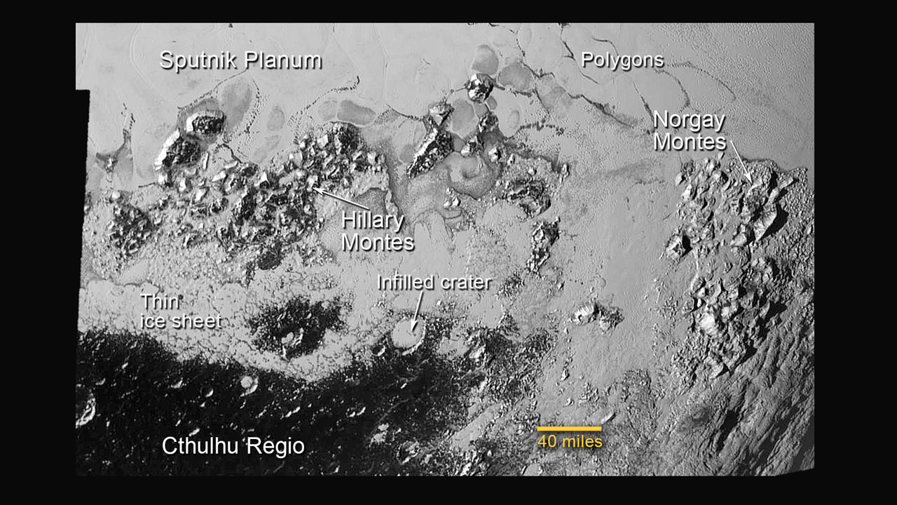
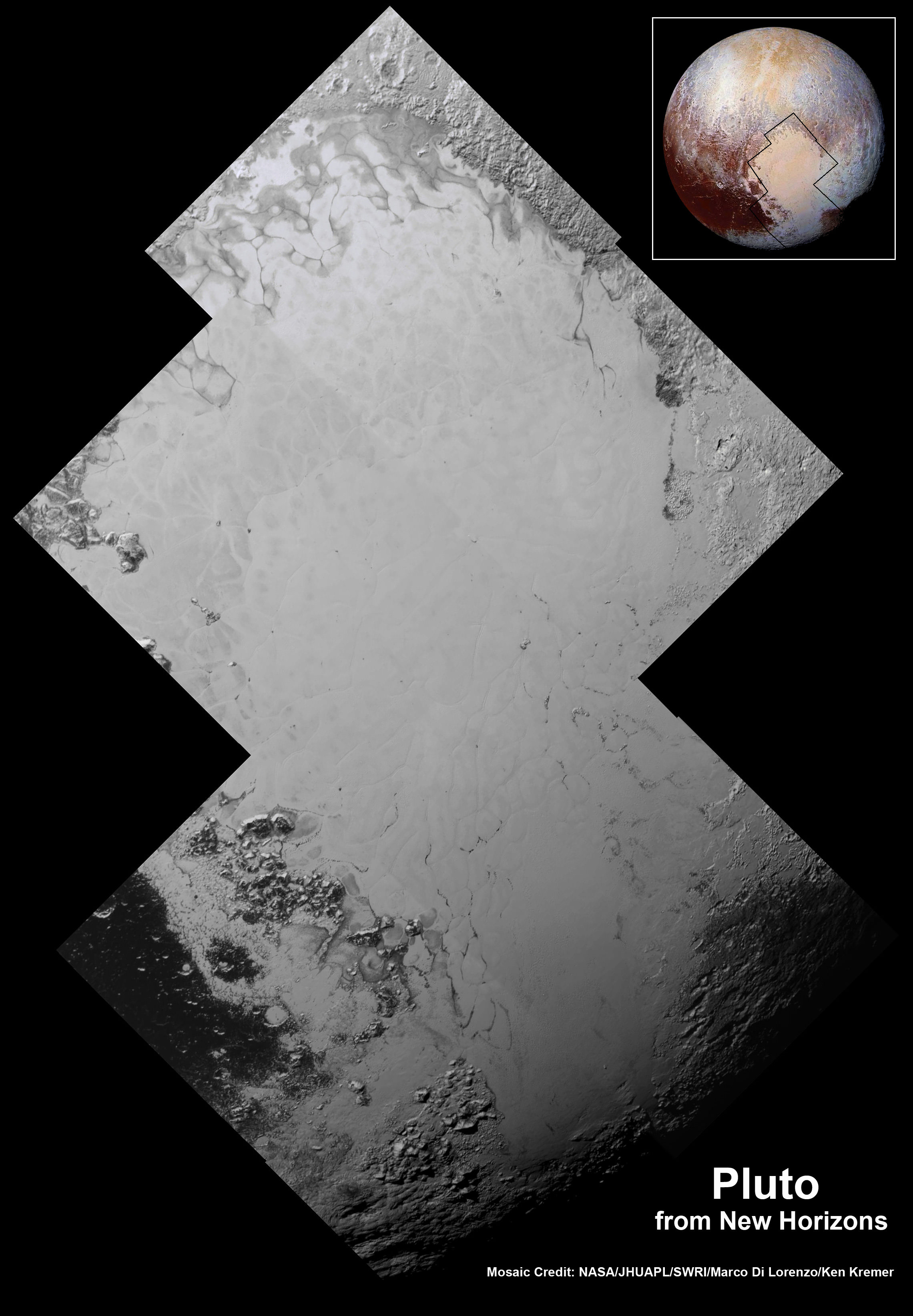
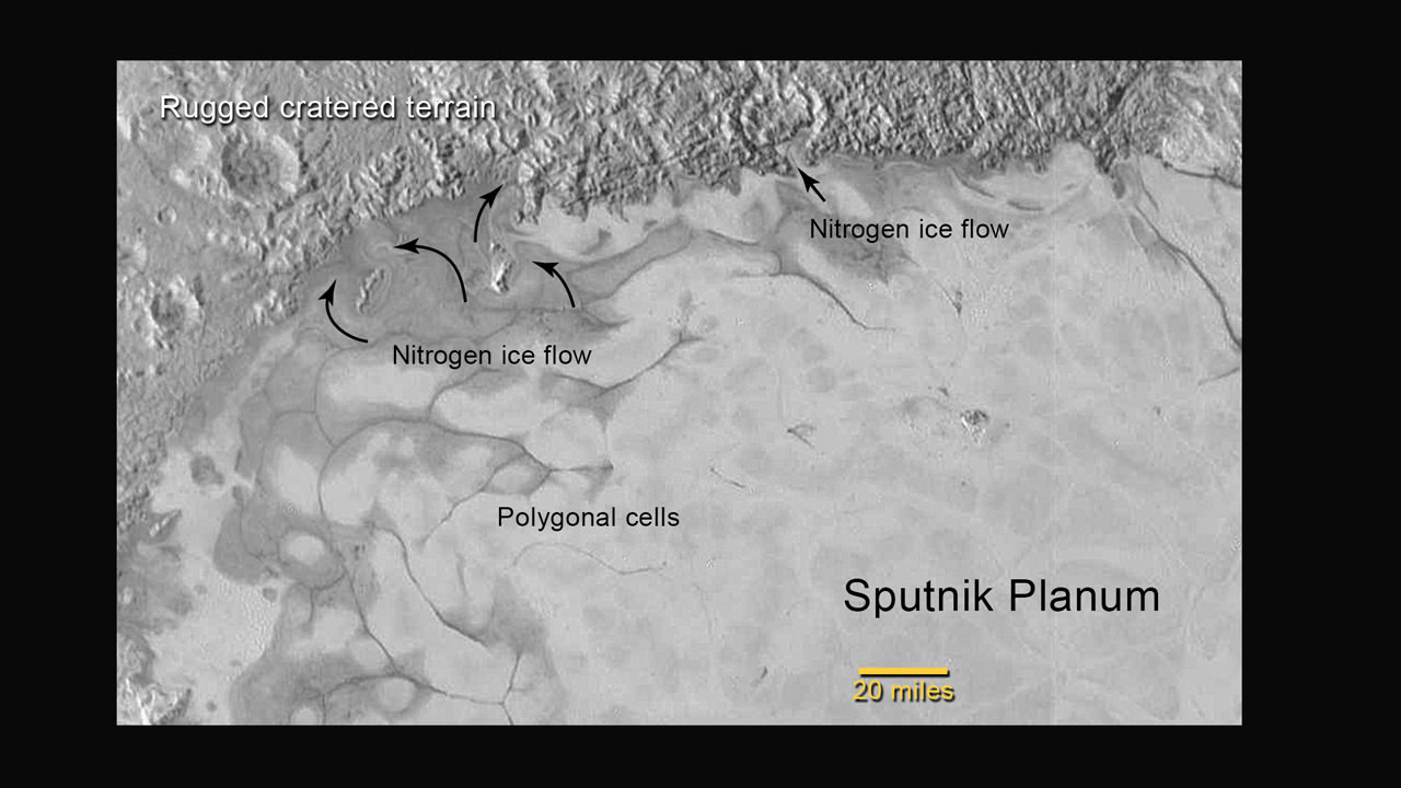
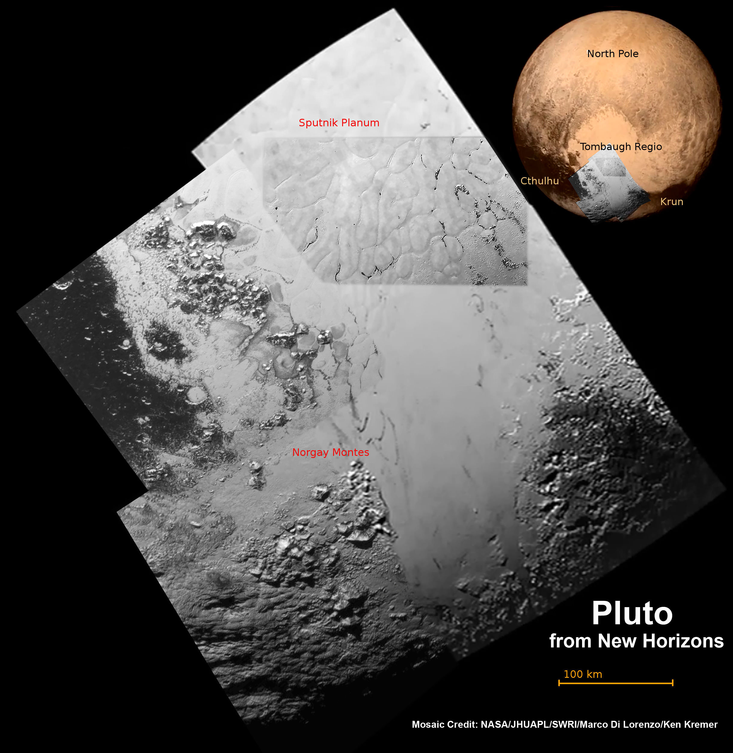
Highest resolution mosaic of ‘Tombaugh Regio’ shows the heart-shaped region on Pluto focusing on ice flows and plains of ‘Sputnik Planum’ at top and icy mountain ranges of ‘Hillary Montes’ and ‘Norgay Montes’ below. This new mosaic combines the seven highest resolution images captured by NASA’s New Horizons LORRI imager during history making closest approach flyby on July 14, 2015. Inset at right shows global view of Pluto with location of mosaic and huge heart-shaped region in context. Annotated with place names. Credit: NASA/JHUAPL/SWRI/ Marco Di Lorenzo/Ken Kremer/kenkremer.com

Highest resolution mosaic of ‘Tombaugh Regio’ shows the heart-shaped region on Pluto focusing on ice flows and plains of ‘Sputnik Planum’ at top and icy mountain ranges of ‘Hillary Montes’ and ‘Norgay Montes’ below. This new mosaic combines the seven highest resolution images captured by NASA’s New Horizons LORRI imager during history making closest approach flyby on July 14, 2015. Inset at right shows global view of Pluto with location of mosaic and huge heart-shaped region in context. Annotated with place names. Credit: NASA/JHUAPL/SWRI/ Marco Di Lorenzo/Ken Kremer/kenkremer.com
Unannotated version below[/caption]

Until barely two weeks ago, Pluto tantalized humanity for eight decades with mysteries we could only imagine – seen as just a point of light or fuzzy blob in the world’s most powerful telescopes.

Now the last explored planetary system in our solar system is being revealed for the first time in history to human eyes, piece by piece, in the form of the highest resolution flyover mosaics and movies of the alien surface ever available, now and for decades to come.

And it’s all thanks to the brilliant efforts of the scientists and engineers leading NASA’s New Horizons mission – which culminated in the first ever close encounter with Pluto and its five moons by a spacecraft from Earth on July 14, 2015.

With the resoundingly successful close flyby completed and the piano shaped New Horizons probe now looking in the rear view mirror, the scientific booty is raining down on receivers back on Earth. However it will take about 16 months to send all the flyby science data back to Earth due to limited bandwidth.

The first series of seven breathtaking high resolution surface images focusing on Pluto’s bright heart-shaped region, informally named ‘Tombaugh Regio’, has been stitched together into our new and wider view mosaic, shown above and below, by the image processing team of Marco Di Lorenzo and Ken Kremer.

Furthermore the New Horizons team has created a spectacular simulated flyover movie centered in the heart of Pluto’s huge ‘Heart’ at ‘Tombaugh Regio’, showing the stunning views including the incredibly recent ice flows and plains of ‘Sputnik Planum’ and monumental icy mountain ranges of ‘Norgay Montes’ and newly discovered ‘Hillary Montes.’

The mosaic and movie are compiled from the seven highest resolution images captured by NASA’s New Horizons LORRI imager during the history making closest approach flyby.

The LORRI images were taken from a distance of 48,000 miles (77,000 kilometers) from the surface of the planet about 1.5 hours prior to the closest approach at 7:49 a.m. EDT on July 14. The images easily resolve structures smaller than a mile across.

New Horizon’s unveiled Pluto as a surprising vibrant and geologically active “icy world of wonders” as it barreled past the Pluto-Charon double planet system on July 14 at over 31,000 mph (49,600 kph) and collected unprecedented high resolution imagery and spectral measurements of the utterly alien worlds.

This annotated image of the southern region of Sputnik Planum illustrates its complexity, including the polygonal shapes of Pluto’s icy plains, its two mountain ranges, and a region where it appears that ancient, heavily-cratered terrain has been invaded by much newer icy deposits. The large crater highlighted in the image is about 30 miles (50 kilometers) wide, approximately the size of the greater Washington, DC area.  Credits: NASA/JHUAPL/SwRI
This annotated image of the southern region of Sputnik Planum illustrates its complexity, including the polygonal shapes of Pluto’s icy plains, its two mountain ranges, and a region where it appears that ancient, heavily-cratered terrain has been invaded by much newer icy deposits. The large crater highlighted in the image is about 30 miles (50 kilometers) wide, approximately the size of the greater Washington, DC area. Credits: NASA/JHUAPL/SwRI

The newly-discovered mountain range has been informally named Hillary Montes (Hillary Mountains) for Sir Edmund Hillary, who first summited Mount Everest with Tenzing Norgay in 1953. They rise about one mile (1.6 kilometers) above the surrounding plains, similar to the height of the Appalachian Mountains in the United States.

They are located nearby and somewhat north of another mountain range discovered first and named Norgay Montes (Norgay Mountains).

“For many years, we referred to Pluto as the Everest of planetary exploration,” said New Horizons Principal Investigator Alan Stern of the Southwest Research Institute, Boulder, Colorado.

“It’s fitting that the two climbers who first summited Earth’s highest mountain, Edmund Hillary and Tenzing Norgay, now have their names on this new Everest.”

Watch this flyover above Pluto’s icy plains at Sputnik Planum and Hillary Montes:

Video caption: This simulated flyover of two regions on Pluto, northwestern Sputnik Planum (Sputnik Plain) and Hillary Montes (Hillary Mountains), was created from New Horizons close-approach images. Sputnik Planum has been informally named for Earth’s first artificial satellite, launched in 1957. Hillary Montes have been informally named for Sir Edmund Hillary, one of the first two humans to reach the summit of Mount Everest in 1953. The images were acquired by the Long Range Reconnaissance Imager (LORRI) on July 14 from a distance of 48,000 miles (77,000 kilometers). Features as small as one-half mile (1 kilometer) across are visible. Credit: NASA/JHUAPL/SwRI

The LORRI images show “extensive evidence of exotic ices flowing across Pluto’s surface and revealing signs of recent geologic activity, something scientists hoped to find but didn’t expect.”

Sputnik Planum is a Texas-sized plain, which lies on the western, left half of Pluto’s bilobed and bright heart-shaped feature, known as Tombaugh Regio.

The new imagery and spectral evidence from the Ralph instrument appears to show the flow of nitrogen ices in geologically recent times across a vast region. They appear to flow similar to glaciers on Earth. There are also carbon monoxide and methane ices mixed in with the water ices.

“At Pluto’s temperatures of minus-390 degrees Fahrenheit, these ices can flow like a glacier,” said Bill McKinnon, deputy leader of the New Horizons Geology, Geophysics and Imaging team at Washington University in St. Louis.

“In the southernmost region of the heart, adjacent to the dark equatorial region, it appears that ancient, heavily-cratered terrain has been invaded by much newer icy deposits.”

“We see the flow of viscous ice that looks like glacial flow.”

Highest resolution mosaic of ‘Tombaugh Regio’ shows the heart-shaped region on Pluto focusing on ice flows and plains of ‘Sputnik Planum’ at top and icy mountain ranges of ‘Hillary Montes’ and ‘Norgay Montes’ below.  This new mosaic combines the seven highest resolution images captured by NASA’s New Horizons LORRI imager during history making closest approach flyby on July 14, 2015.  Inset at right shows global view of Pluto with location of mosaic and huge heart-shaped region in context.  Credit: NASA/JHUAPL/SWRI/Marco Di Lorenzo/Ken Kremer/kenkremer.com
Highest resolution mosaic of ‘Tombaugh Regio’ shows the heart-shaped region on Pluto focusing on ice flows and plains of ‘Sputnik Planum’ at top and icy mountain ranges of ‘Hillary Montes’ and ‘Norgay Montes’ below. This new mosaic combines the seven highest resolution images captured by NASA’s New Horizons LORRI imager during history making closest approach flyby on July 14, 2015. Inset at right shows global view of Pluto with location of mosaic and huge heart-shaped region in context. Credit: NASA/JHUAPL/SWRI/Marco Di Lorenzo/Ken Kremer/kenkremer.com

As of today, July 26, New Horizons is 12 days past the Pluto flyby and already over 15 million kilometers beyond Pluto and continuing its journey into the Kuiper Belt, the third realm of worlds in our solar system.

New Horizons discovered that Pluto is the largest known body beyond Neptune – and thus reigns as the “King of the Kuiper Belt!”

The science team plans to target New Horizons to fly by another smaller Kuiper Belt Object (KBO) as soon as 2018.

Watch for Ken’s continuing coverage of the Pluto flyby. He was onsite reporting live on the flyby and media briefings for Universe Today from the Johns Hopkins University Applied Physics Laboratory (APL), in Laurel, Md.

Stay tuned here for Ken’s continuing Earth and planetary science and human spaceflight news.
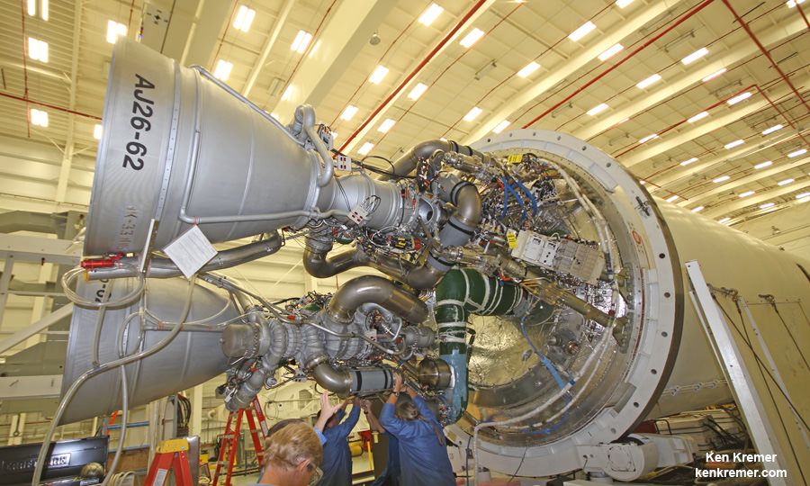
Ken Kremer

Four images from New Horizons’ Long Range Reconnaissance Imager (LORRI) were combined with color data from the Ralph instrument to create this enhanced color global view of Pluto. (The lower right edge of Pluto in this view currently lacks high-resolution color coverage.) The images, taken when the spacecraft was 280,000 miles (450,000 kilometers) away, show features as small as 1.4 miles (2.2 kilometers), twice the resolution of the single-image view taken on July 13.  Credits: NASA/JHUAPL/SwRI
Four images from New Horizons’ Long Range Reconnaissance Imager (LORRI) were combined with color data from the Ralph instrument to create this enhanced color global view of Pluto. (The lower right edge of Pluto in this view currently lacks high-resolution color coverage.) The images, taken when the spacecraft was 280,000 miles (450,000 kilometers) away, show features as small as 1.4 miles (2.2 kilometers), twice the resolution of the single-image view taken on July 13. Credits: NASA/JHUAPL/SwRI

Flowing Ice, Exotic Mountains and Backlit Haze Highlight Pluto as Never Seen Before

Backlit by the sun, Pluto’s atmosphere rings its silhouette like a luminous halo in this image taken by NASA’s New Horizons spacecraft around midnight EDT on July 15. This global portrait of the atmosphere was captured when the spacecraft was about 1.25 million miles (2 million kilometers) from Pluto and shows structures as small as 12 miles across. The image, delivered to Earth on July 23, is displayed with north at the top of the frame. Credits: NASA/JHUAPL/SwRI

Spectacular imagery of huge regions of flowing ice, monumental mountain ranges and a breathtakingly backlit atmospheric haze showing Pluto as we’ve never seen it before, were among the newest discoveries announced today, July 24, by scientists leading NASA’s New Horizons mission which sped past the planet for humanity’s first ever up-close encounter only last week.

New Horizon’s revealed Pluto be an unexpectedly vibrant “icy world of wonders” as it barreled by the Pluto-Charon double planet system last Tuesday, July 14, at over 31,000 mph (49,600 kph).

The scientists publicly released a series of stunning new images and science discoveries at Pluto that exceeded all pre-flyby expectations.

“The images of Pluto are spectacular,” said John Grunsfeld, NASA’s associate administrator for the Science Mission Directorate, at today’s media briefing.

“We knew that a mission to Pluto would bring some surprises, and now — 10 days after closest approach — we can say that our expectation has been more than surpassed. With flowing ices, exotic surface chemistry, mountain ranges, and vast haze, Pluto is showing a diversity of planetary geology that is truly thrilling.”

New Horizons discovers flowing ices in Pluto’s heart-shaped feature. In the northern region of Pluto’s Sputnik Planum (Sputnik Plain), swirl-shaped patterns of light and dark suggest that a surface layer of exotic ices has flowed around obstacles and into depressions, much like glaciers on Earth.  Credits: NASA/JHUAPL/SwRI
New Horizons discovers flowing ices in Pluto’s heart-shaped feature. In the northern region of Pluto’s Sputnik Planum (Sputnik Plain), swirl-shaped patterns of light and dark suggest that a surface layer of exotic ices has flowed around obstacles and into depressions, much like glaciers on Earth. Credits: NASA/JHUAPL/SwRI

Over 50 gigabits of data were collected during the encounter and flyby periods of the highest scientific activity in the most critical hours before and after the spacecrafts closest approach to Pluto, its largest moon Charon and its quartet of smaller moons.

Data from the flyby is now raining back to Earth, but slowly due to limited bandwidth of an average “downlink” of only about 2 kilobits per second via its two transmitters.

“So far we’ve seen only about 5% of the encounter data,” said Jim Green, director of Planetary Science at NASA Headquarters in Washington.

At that pace it will take about 16 months to send all the flyby science data back to Earth.

Among the top highlights is the first view ever taken from the back side of Pluto, a backlit view that humans have never seen before.

It shows a global portrait of the planets extended atmosphere and was captured when NASA’s New Horizons spacecraft was about 1.25 million miles (2 million kilometers) from Pluto. It shows structures as small as 12 miles across.

“The silhouette of Pluto taken after the flyby and show a remarkable haze of light representing the hazy worlds extended atmosphere,” Alan Stern, principal investigator for New Horizons at the Southwest Research Institute (SwRI) in Boulder, Colorado, said at the media briefing.

“The image is the equivalent of the Apollo astronauts Earth-rise images.”

“It’s the first image of Pluto’s atmosphere!” said Michael Summers, New Horizons co-investigator at George Mason University in Fairfax, Virginia, at the briefing.

“We’ve known about the atmosphere for over 25 years,” and now we can see it. There are haze layers and it shows structure and weather. There are two distinct layers of haze. One at about 30 miles (50 kilometers) and another at about 50 miles (80 kilometers) above the surface.”

“The haze extend out about 100 miles! Which is five times more than expected.”

This annotated image of the southern region of Sputnik Planum illustrates its complexity, including the polygonal shapes of Pluto’s icy plains, its two mountain ranges, and a region where it appears that ancient, heavily-cratered terrain has been invaded by much newer icy deposits. The large crater highlighted in the image is about 30 miles (50 kilometers) wide, approximately the size of the greater Washington, DC area.  Credits: NASA/JHUAPL/SwRI
This annotated image of the southern region of Sputnik Planum illustrates its complexity, including the polygonal shapes of Pluto’s icy plains, its two mountain ranges, and a region where it appears that ancient, heavily-cratered terrain has been invaded by much newer icy deposits. The large crater highlighted in the image is about 30 miles (50 kilometers) wide, approximately the size of the greater Washington, DC area. Credits: NASA/JHUAPL/SwRI

The image was taken by New Horizons’ high resolution Long Range Reconnaissance Imager (LORRI) while looking back at Pluto, barely seven hours after closest approach at 7:49 a.m. EDT on July 14, and gives significant clues about the atmosphere’s dynamics and interaction with the surface. It captures sunlight streaming through the atmosphere.

“The hazes detected in this image are a key element in creating the complex hydrocarbon compounds that give Pluto’s surface its reddish hue.”

Methane (CH4) in the upper atmosphere break down by interaction of UV radiation and forms ethylene and acetylene which leads to more complex hydrocarbons known as tholins – which the team says is responsible for Pluto’s remarkable reddish hue.

The team also released new LORRI images showing “extensive evidence of exotic ices flowing across Pluto’s surface and revealing signs of recent geologic activity, something scientists hoped to find but didn’t expect.”

The images focuses on Sputnik Planum, a Texas-sized plain, which lies on the western, left half of Pluto’s bilobed and bright heart-shaped feature, known as Tombaugh Regio.

Pluto and Charon are shown in a composite of natural-color images from New Horizons. Images from the Long Range Reconnaissance Imager (LORRI) were combined with color data from the Ralph instrument to produce these views, which portray Pluto and Charon as an observer riding on the spacecraft would see them. The images were acquired on July 13 and 14, 2015.   Credit: NASA/JHUAPL/SWRI
Pluto and Charon are shown in a composite of natural-color images from New Horizons. Images from the Long Range Reconnaissance Imager (LORRI) were combined with color data from the Ralph instrument to produce these views, which portray Pluto and Charon as an observer riding on the spacecraft would see them. The images were acquired on July 13 and 14, 2015. Credit: NASA/JHUAPL/SWRI

New imagery and spectral evidence from the Ralph instrument was presented that appears to show the flow of nitrogen ices in geologically recent times across a vast region. They appear to flow similar to glaciers on Earth. There are also carbon monoxide and methane ices mixed in with the water ices.

“We’ve only seen surfaces like this on active worlds like Earth and Mars,” said mission co-investigator John Spencer of SwRI. “I’m really smiling.”

“At Pluto’s temperatures of minus-390 degrees Fahrenheit, these ices can flow like a glacier,” said Bill McKinnon, deputy leader of the New Horizons Geology, Geophysics and Imaging team at Washington University in St. Louis.

“In the southernmost region of the heart, adjacent to the dark equatorial region, it appears that ancient, heavily-cratered terrain has been invaded by much newer icy deposits.”

“We see the flow of viscous ice that looks like glacial flow.”

Four images from New Horizons’ Long Range Reconnaissance Imager (LORRI) were combined with color data from the Ralph instrument to create this enhanced color global view of Pluto. (The lower right edge of Pluto in this view currently lacks high-resolution color coverage.) The images, taken when the spacecraft was 280,000 miles (450,000 kilometers) away, show features as small as 1.4 miles (2.2 kilometers), twice the resolution of the single-image view taken on July 13.  Credits: NASA/JHUAPL/SwRI
Four images from New Horizons’ Long Range Reconnaissance Imager (LORRI) were combined with color data from the Ralph instrument to create this enhanced color global view of Pluto. (The lower right edge of Pluto in this view currently lacks high-resolution color coverage.) The images, taken when the spacecraft was 280,000 miles (450,000 kilometers) away, show features as small as 1.4 miles (2.2 kilometers), twice the resolution of the single-image view taken on July 13. Credits: NASA/JHUAPL/SwRI

If the spacecraft remains healthy as expected, the science team plans to target New Horizons to fly by another smaller Kuiper Belt Object (KBO) as soon as 2018.

Watch for Ken’s continuing coverage of the Pluto flyby. He was onsite reporting live on the flyby and media briefings for Universe Today from the Johns Hopkins University Applied Physics Laboratory (APL), in Laurel, Md.

Stay tuned here for Ken’s continuing Earth and planetary science and human spaceflight news.

Ken Kremer

Hi Res mosaic of ‘Tombaugh Regio’ shows the heart-shaped region on Pluto and focuses on icy mountain ranges of ‘Norgay Montes’ and ice plains of ‘Sputnik Planum.’ The new mosaic combines highest resolution imagery captured by NASA’s New Horizons LORRI imager during history making closest approach flyby on July 14, 2015, draped over a wider, lower resolution view of Tombaugh Regio.   Inset at left shows possible wind streaks.  Inset at right shows global view of Pluto with location of huge heart-shaped region in context.  Annotated with place names.  Credit: NASA/JHUAPL/SWRI/ Marco Di Lorenzo/Ken Kremer/kenkremer.com
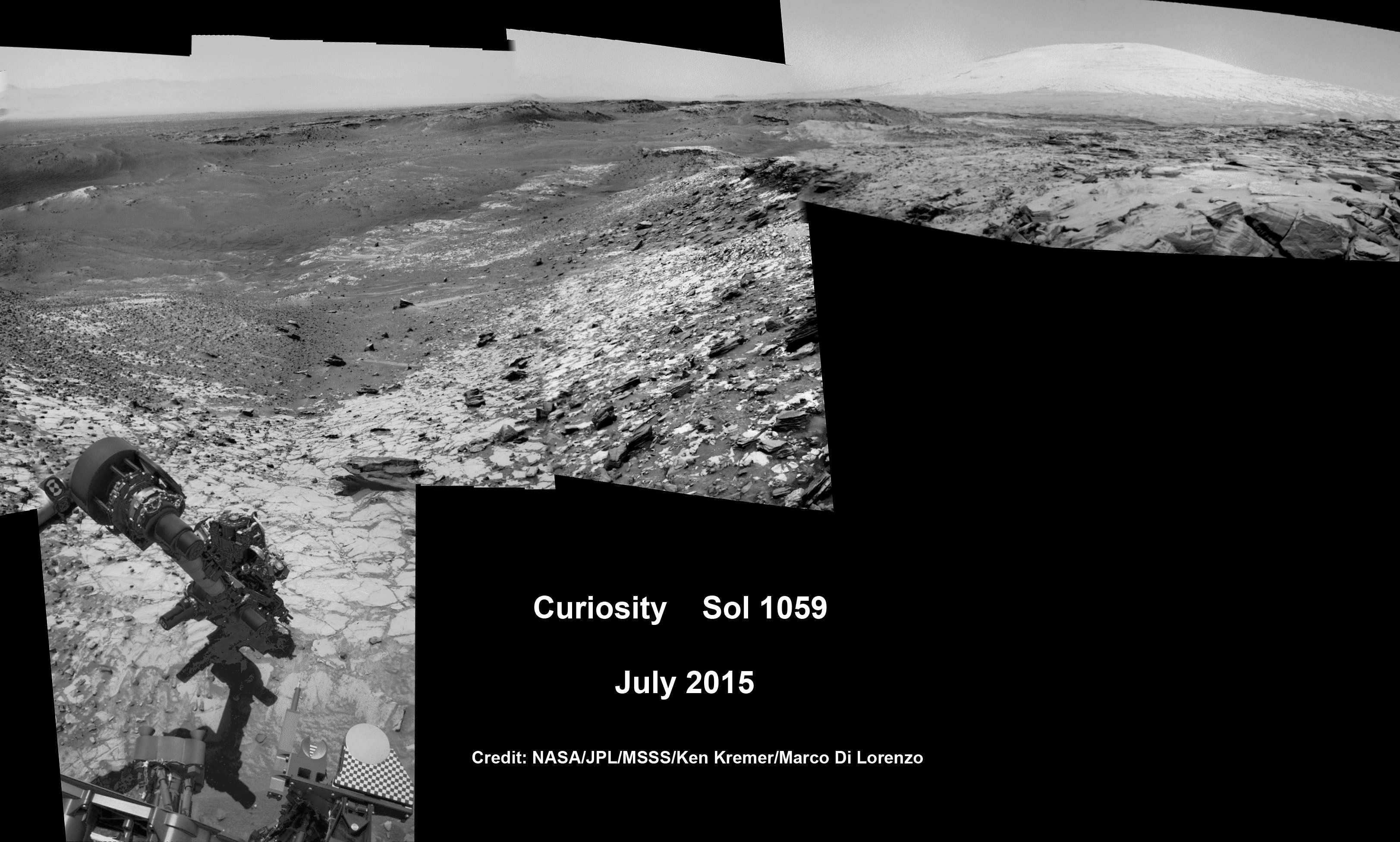
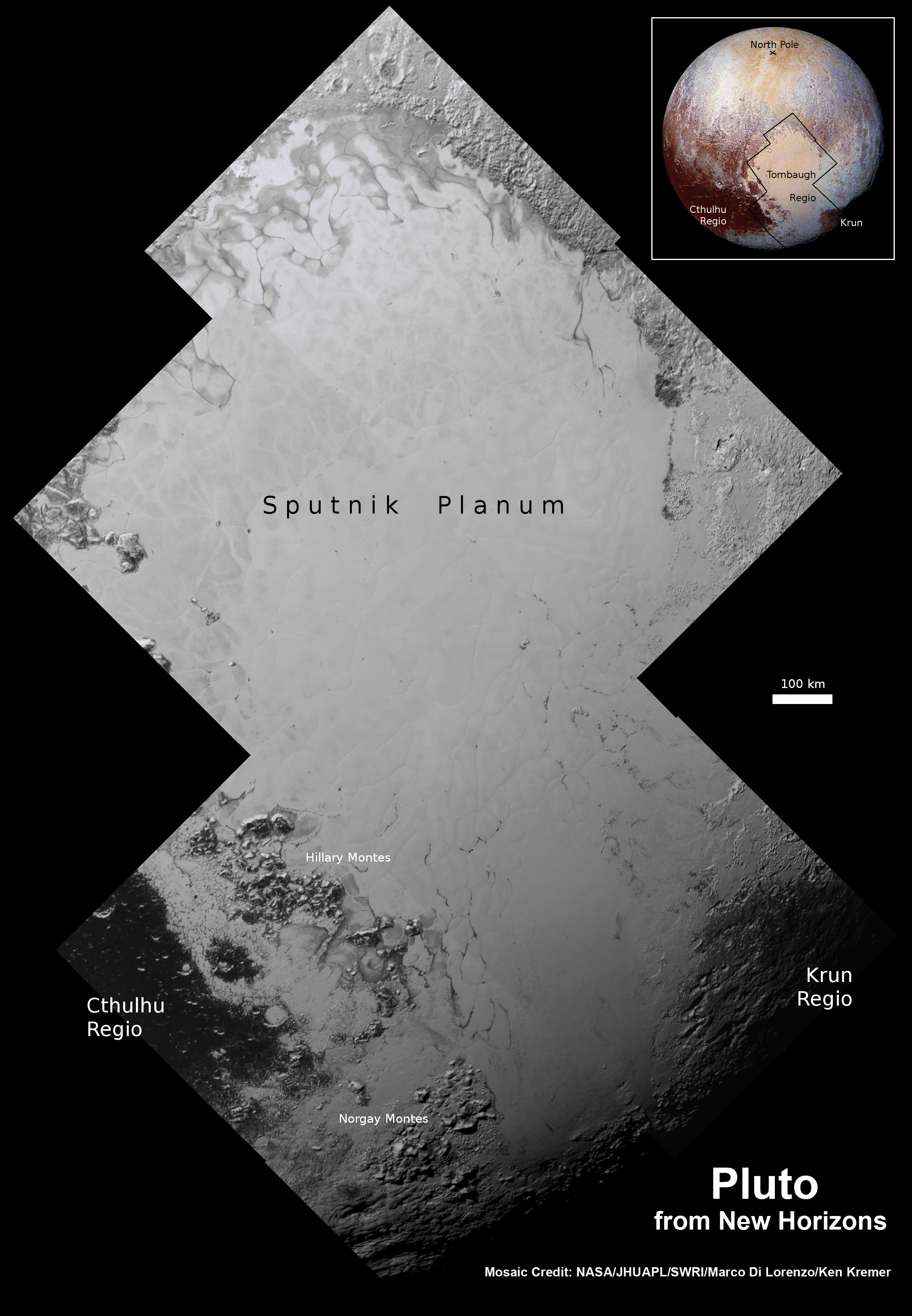
Hi Res mosaic of ‘Tombaugh Regio’ shows the heart-shaped region on Pluto and focuses on icy mountain ranges of ‘Norgay Montes’ and ice plains of ‘Sputnik Planum.’ The new mosaic combines highest resolution imagery captured by NASA’s New Horizons LORRI imager during history making closest approach flyby on July 14, 2015, draped over a wider, lower resolution view of Tombaugh Regio. Inset at left shows possible wind streaks. Inset at right shows global view of Pluto with location of huge heart-shaped region in context. Annotated with place names. Credit: NASA/JHUAPL/SWRI/ Marco Di Lorenzo/Ken Kremer/kenkremer.com