Dr. Ken Kremer is a speaker, research scientist, freelance science journalist (KSC area,FL) and photographer whose articles, space exploration images and Mars mosaics have appeared in magazines, books, websites and calendars including Astronomy Picture of the Day, NBC, FOX, BBC, SPACE.com, Spaceflight Now, Science and the covers of Aviation Week & Space Technology, Spaceflight and the Explorers Club magazines. Ken has presented at numerous educational institutions, civic & religious organizations, museums and astronomy clubs. Ken has reported first hand from the Kennedy Space Center, Cape Canaveral, NASA Wallops, NASA Michoud/Stennis/Langley and on over 80 launches including 8 shuttle launches. He lectures on both Human and Robotic spaceflight - www.kenkremer.com. Follow Ken on Facebook and Twitter
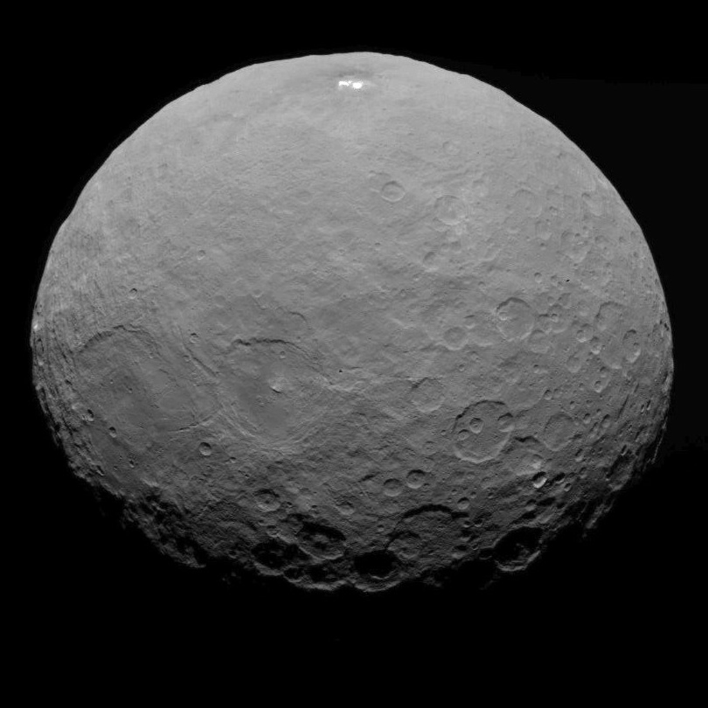
This image of Ceres was taken by NASA's Dawn spacecraft on May 7, 2015, from a distance of 8,400 miles (13,600 kilometers). Credit: NASA/JPL-Caltech/UCLA/MPS/DLR/IDA
Video caption: This new video animation of Ceres was created from images taken by NASA’s Dawn spacecraft at altitudes of 8,400 miles (13,600 kilometers) and 3,200 miles (5,100 kilometers) away. Vertical dimension has been exaggerated by a factor of two and a star field added. Credit: NASA/JPL-Caltech/UCLA/MPS/DLR/IDA
Scientists leading NASA’s Dawn mission to dwarf planet Ceres have just released a brand new animated video showing a dramatic fly over of the heavily cratered world featuring its mysterious bright spots whose exact origin and nature remain elusive.
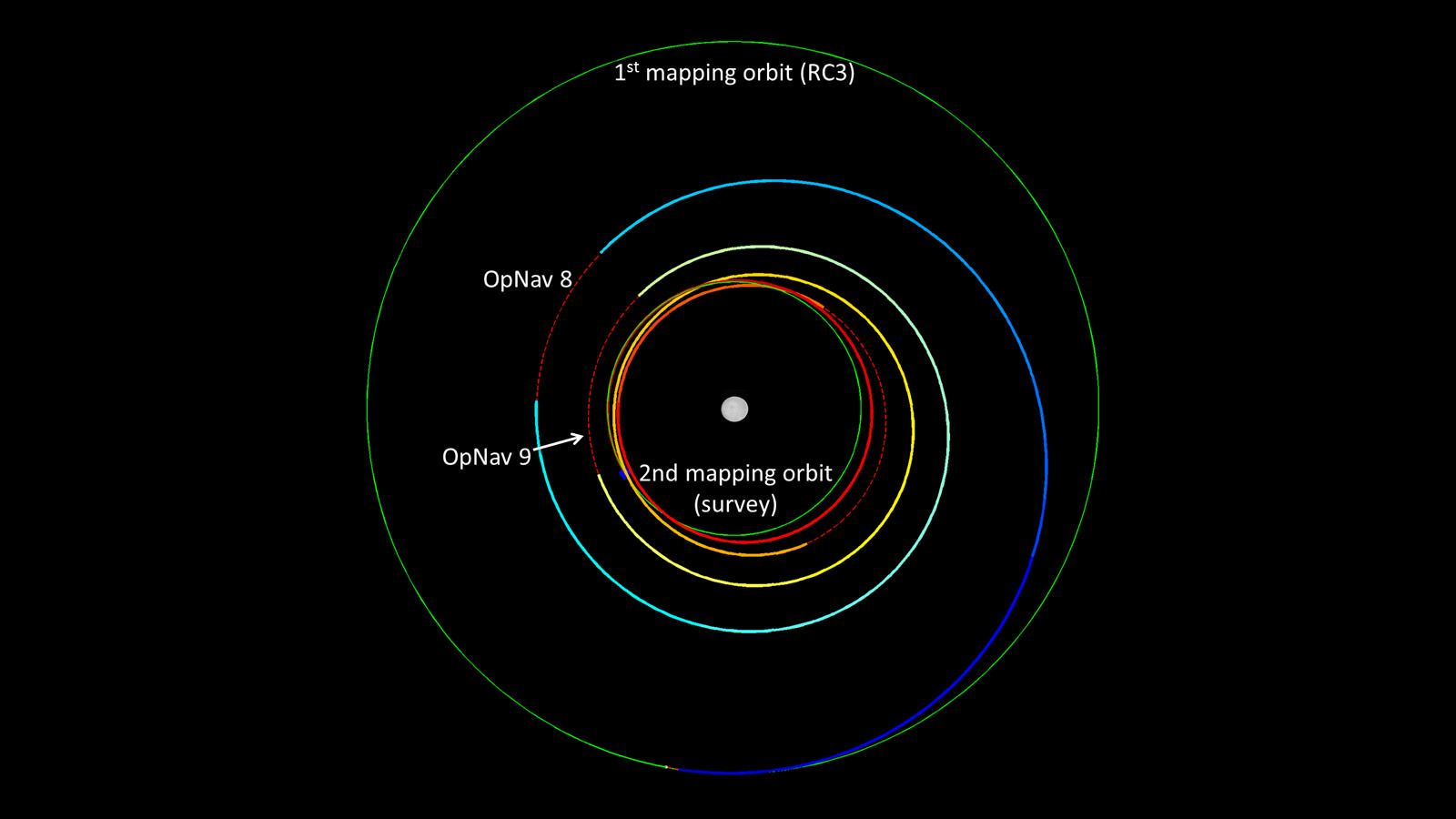
Meanwhile, the venerable probe has just successfully entered its new and lower mapping orbit on June 3 from which researchers hope to glean hordes of new data to unravel the secrets of the bright spots and unlock the nature of Ceres origin and evolution.
Pockmarked Ceres is an alien world unlike any other in our solar system.
“Dawn completed the maneuvering to reach its second mapping orbit and stopped ion-thrusting on schedule. Since May 9, the spacecraft has reduced its orbital altitude from 8,400 miles (13,600 kilometers) to 2,700 miles (4,400 kilometers),” reported Marc Rayman, Dawn Chief Engineer/ Mission Director of NASA’s Jet Propulsion Laboratory, Pasadena, California.
“As Dawn flew 2,700 miles (4,400 kilometers) over Ceres’ north pole on June 5 that marked the beginning of the new mapping phase, and Dawn began taking photos and making other measurements on schedule.”
Each orbit of Dawn around Ceres at this second science mapping orbit lasts 3.1 days.
The new video was created by the research team based on observations of Ceres that were taken from Dawn’s initial mapping orbit, at an altitude of 8,400 miles (13,600 kilometers), as well as the most recent navigational images taken from 3,200 miles (5,100 kilometers), according to NASA.
It is based on data from over 80 images captured by Dawn’s framing cameras which were provided The German Aerospace Center (DLR) and Max Planck Institute for Solar System Research in Göttingen, Germany.
The images were used to provide a three-dimensional video view. The vertical dimension is exaggerated by a factor of two in the video.
“We used a three-dimensional terrain model that we had produced based on the images acquired so far,” said Dawn team member Ralf Jaumann of the German Aerospace Center (DLR), in Berlin.
“They will become increasingly detailed as the mission progresses — with each additional orbit bringing us closer to the surface.”
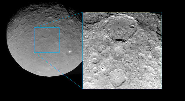
Imagery of the mysterious bright spots show them to seemingly be sheets of many spots of water ice, and not just single huge patches. The famous duo of ice spots are located inside the middle of a 57 miles (92 kilometers) wide crater situated in Ceres northern hemisphere.
Dawn is an international science mission managed by NASA’s Jet Propulsion Laboratory, Pasadena, California. The trio of science instruments are from the US, Germany and Italy.
The framing camera was provided by the Max Planck Institute for Solar System Research, Göttingen, Germany and the German Aerospace Center (DLR).
This view of Ceres was taken by Dawn spacecraft on May 23 and shows finer detail becoming visible on the dwarf planet. The spacecraft snapped the image at a distance of 3,200 miles (5,100 kilometers) with a resolution of 1,600 feet (480 meters) per pixel. Credit: NASA/JPL-Caltech/UCLA/MPS/DLR/IDA
Dawn will spend most if June at this second mapping orbit before firing up the ion engines and spiraling yet lower for a mission expected to last until at least June 2016.
Stay tuned here for Ken’s continuing Earth and planetary science and human spaceflight news.
Dawn’s spiral descent from its first mapping orbit (RC3) to its second (survey). The two mapping orbits are shown in green. The color of Dawn’s trajectory progresses through the spectrum from blue, when it began ion-thrusting on May 9, to red, when ion-thrusting concludes on June 3. The red dashed sections show where Dawn is coasting, mostly for telecommunications. The first two coast periods include OpNav 8 and 9. Image credit: NASA/JPL-Caltech
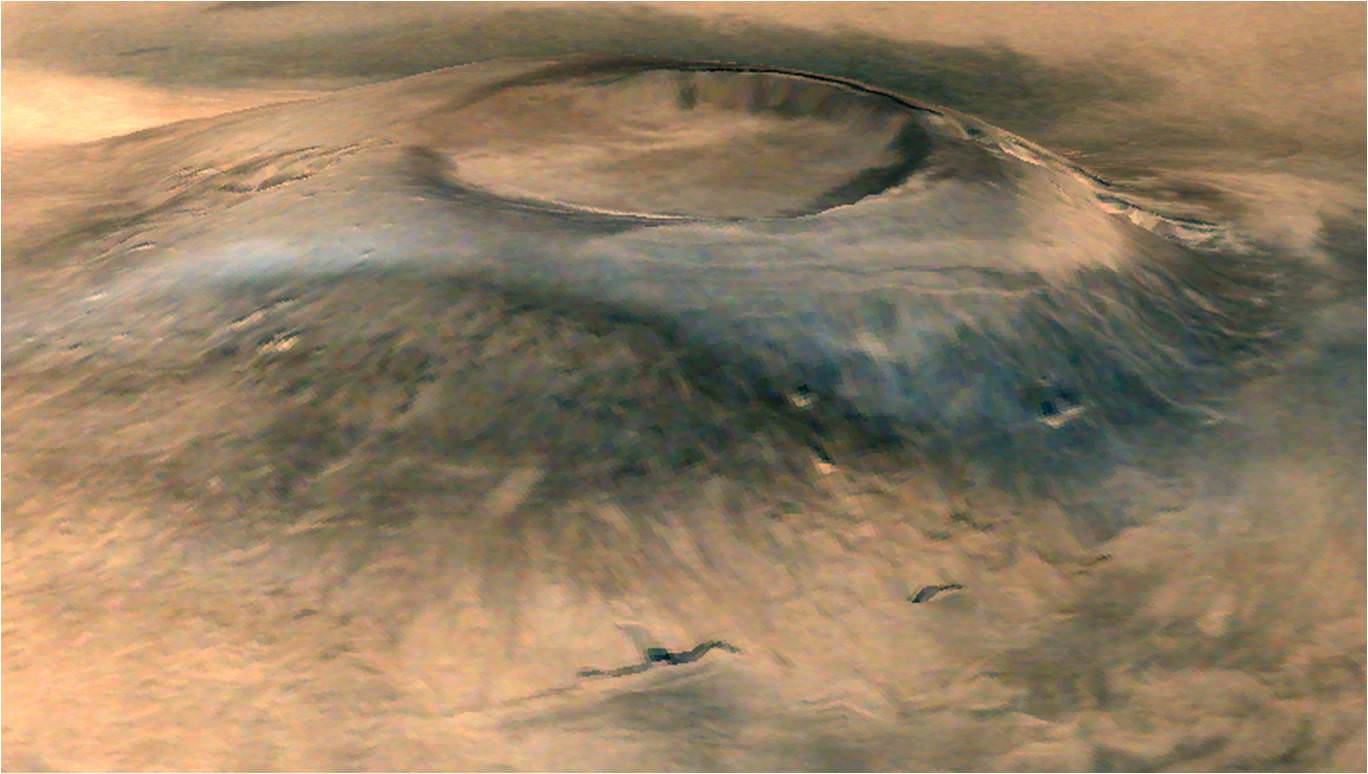
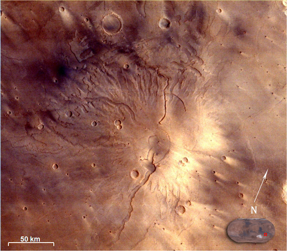
Spectacular 3D view of Arsia Mons, a huge volcano on Mars, taken by camera on India's Mars Orbiter Mission (MOM). Credit: ISRO
Spectacular 3D view of Arsia Mons, a huge volcano on Mars, taken by camera on India’s Mars Orbiter Mission (MOM). Credit: ISRO
Story updated with more details and imagery[/caption]
The Indian Space Research Organization (ISRO), India’s space agency, has recently published a beautiful gallery of images featuring a variety of picturesque Martian canyons, volcanoes, craters, moons and more.
We’ve gathered a collection here of MOM’s newest imagery snapped by the probes Mars Color Camera (MCC) for the enjoyment of Martian fans worldwide.
The spectacular 3D view of the Arsia Mons volcano, shown above, was “created by draping the MCC image on topography of the region derived from the Mars Orbiter Laser Altimeter (MOLA), one of five instruments on board NASA’s Mars Global Surveyor (MGS) spacecraft.
The Arsia Mons image was taken from Mars orbit on 1 April 2015 at a spatial resolution of 556 meters from an altitude of 10707 km. Volcanic deposits can be seen located at the flanks of the Mons, according to ISRO.
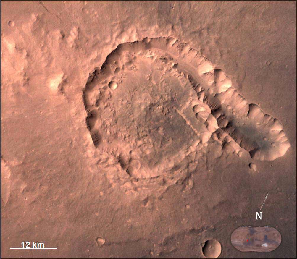
The view of Pital crater below was released in late May and taken on 23 April 2015. Pital is a 40 km wide impact crater located in the Ophir Planum region of Mars and the image shows a chain of small impact craters. It is located in the eastern part of Valles Marineris region, says an ISRO description. MCC took the image from an altitude of 808 km.
Pital crater is an impact crater located in Ophir Planum region of Mars, which is located in the eastern part of Valles Marineris region. This image is taken by Mars Color Camera (MCC) on 23-04-2015 at a spatial resolution of ~42 m from an altitude of 808 km. Credit: ISRO
It is an odd shaped crater, neither circular nor elliptical in shape, possibly due to “regional fracture in the W-E trending fracture zone.”
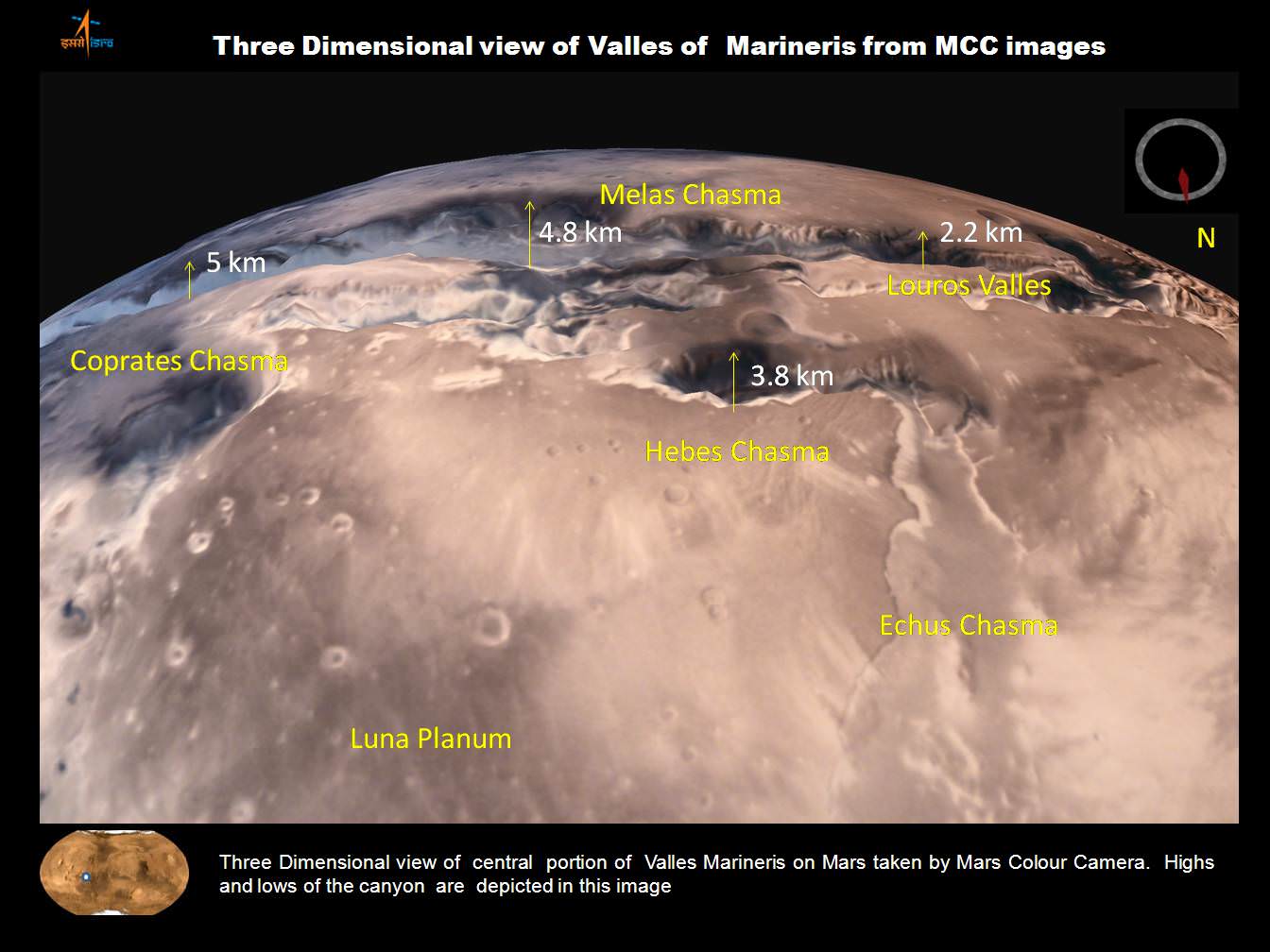
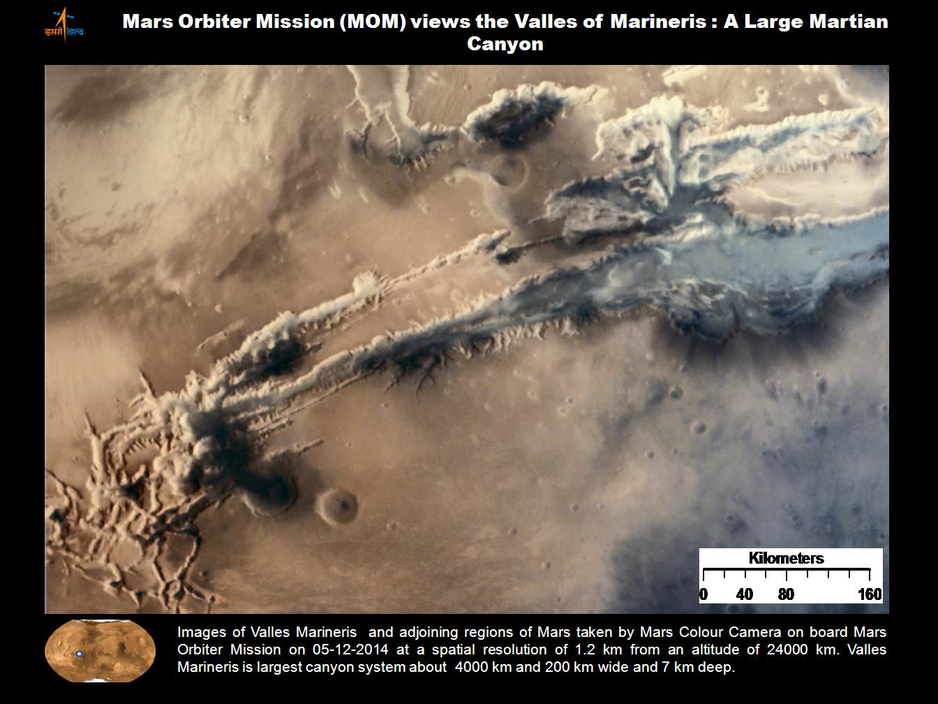
A trio of images, including one in stunning 3D, shows various portions of Valles Marineris, the largest known canyon in the Solar System.
Three dimensional view of Valles Marineris center portion from India’s MOM Mars Mission. Credit: ISRO
Valles Marineris stretches over 4,000 km (2,500 mi) across the Red Planet , is as much as 600 km wide and measures as much as 7 kilometers (4 mi) deep.
Valles Marineris from India’s Mars Mission. Credit: ISRO
For context here’s a previously taken global image of the red planet from MOM showing Valles Marinaris and Arsia Mons, which belongs to the Tharsis Bulge trio of shield volcanoes. They are both near the Martian equator.
Olympus Mons, Tharsis Bulge trio of volcanoes and Valles Marineris from ISRO’s Mars Orbiter Mission. Note the clouds and south polar ice cap. Credit: ISRO
Valles Marineris is often called the “Grand Canyon of Mars.” It spans about as wide as the entire United States.
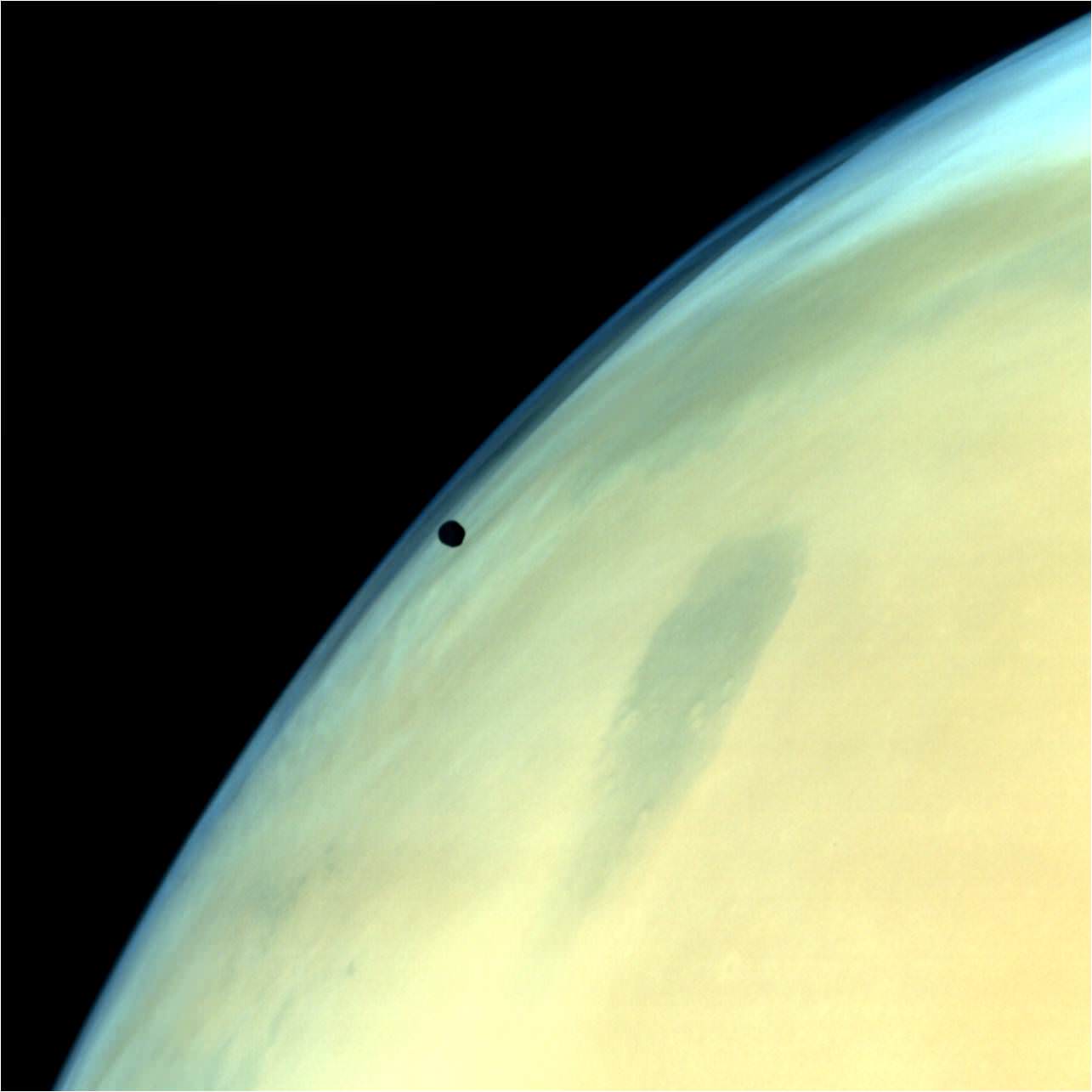
A gorgeous view of Phobos, the largest of Mars’ two tiny moons, silhouetted against the surface is shown below.
Phobos, one of the two natural satellites of Mars silhouetted against the Martian surface. Credit: ISRO
MOM’s goal is to study Mars atmosphere, surface environments, morphology, and mineralogy with a 15 kg (33 lb) suite of five indigenously built science instruments. It is also sniffing for methane, a potential marker for biological activity.
MOM is India’s first deep space voyager to explore beyond the confines of her home planets influence and successfully arrived at the Red Planet after the “history creating” orbital insertion maneuver on Sept. 23/24, 2014 following a ten month journey from Earth. MOM swoops around Mars in a highly elliptical orbit whose nearest point to the planet (periapsis) is at about 421 km and farthest point (apoapsis) at about 76,000 km, according to ISRO.
It takes MOM about 3.2 Earth days or 72 hours to orbit the Red Planet.
Higher resolution view of a portion of Valles Marineris canyon from India’s MOM Mars Mission. Credit: ISRO
MOM was launched on Nov. 5, 2013 from India’s spaceport at the Satish Dhawan Space Centre, Sriharikota, atop the nations indigenous four stage Polar Satellite Launch Vehicle (PSLV) which placed the probe into its initial Earth parking orbit.
The $73 million MOM mission was expected to last at least six months. In March, ISRO extended the mission duration for another six months since its healthy, the five science instruments are operating fine and it has sufficient fuel reserves.
And with a communications blackout between Mars and Earth imminent as a result of natures solar conjunction, it’s the perfect time to catch up on all things Martian.
Solar conjunctions occur periodically between Mars and Earth about every 26 months, when the two planets line up basically in a straight line geometry with the sun in between as the two planets travel in their sun-centered orbits.
Since Mars will be located behind the Sun for most of June, communications with all the Terran spacecraft at the planet is diminished to nonexistent.
“MOM faces a communication outage during June 8-25,” according to The Hindu.
Normal science operations resume thereafter.
“Fuel on the spacecraft is not an issue,” ISRO Satellite Centre Director M. Annadurai told The Hindu.
Image of Tyrrhenus Mons in Hesperia Planum region taken by Mars Color Camera (MCC) on 25-02-2015 at a spatial resolution of 166m from an altitude of 3192km. Tyrrhenus Mons is an ancient martian volcano and image shows its timeworn gullies and wind streaks. Credit: ISRO
Including MOM, Earth’s invasion fleet at the Red Planet numbers a total of seven spacecraft comprising five orbiters from NASA, ESA and ISRO as well as the sister pair of mobile surface rovers from NASA – Curiosity and Opportunity.
Stay tuned here for Ken’s continuing Earth and planetary science and human spaceflight news.
This single frame Rosetta navigation camera image was taken from a distance of 77.8 km from the centre of Comet 67P/Churyumov-Gerasimenko on 22 March 2015. The image has a resolution of 6.6 m/pixel and measures 6 x 6 km. The image is cropped and processed to bring out the details of the comet’s activity. Credit: ESA/Rosetta/NAVCAM – CC BY-SA IGO 3.0
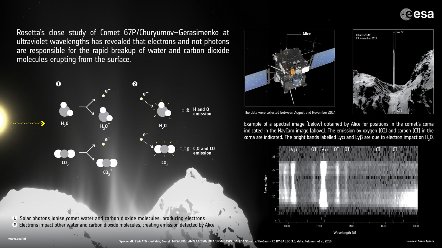
A NASA science instrument flying aboard the European Space Agency’s (ESA) Rosetta spacecraft has made a very surprising discovery – namely that the molecular breakup mechanism of “water and carbon dioxide molecules spewing from the comet’s surface” into the atmosphere of comet 67P/Churyumov-Gerasimenko is caused by “electrons close to the surface.”
The surprising results relating to the emission of the comet coma came from measurements gathered by the probes NASA funded Alice instrument and is causing scientists to completely rethink what we know about the wandering bodies, according to the instruments science team.
“The discovery we’re reporting is quite unexpected,” said Alan Stern, principal investigator for the Alice instrument at the Southwest Research Institute (SwRI) in Boulder, Colorado, in a statement.
“It shows us the value of going to comets to observe them up close, since this discovery simply could not have been made from Earth or Earth orbit with any existing or planned observatory. And, it is fundamentally transforming our knowledge of comets.”
A paper reporting the Alice findings has been accepted for publication by the journal Astronomy and Astrophysics, according to statements from NASA and ESA.
Alice is a spectrograph that focuses on sensing the far-ultraviolet wavelength band and is the first instrument of its kind to operate at a comet.
Until now it had been thought that photons from the sun were responsible for causing the molecular breakup, said the team.
The carbon dioxide and water are being released from the nucleus and the excitation breakup occurs barely half a mile above the comet’s nucleus.
“Analysis of the relative intensities of observed atomic emissions allowed the Alice science team to determine the instrument was directly observing the “parent” molecules of water and carbon dioxide that were being broken up by electrons in the immediate vicinity, about six-tenths of a mile (one kilometer) from the comet’s nucleus.”
The excitation mechanism is detailed in the graphic below.
Rosetta’s continued close study of Comet 67P/Churyumov-Gerasimenko has revealed an unexpected process at work close to the comet nucleus that causes the rapid breakup of water and carbon dioxide molecules. Credits: ESA/ATG medialab; ESA/Rosetta/MPS for OSIRIS Team MPS/UPD/LAM/IAA/SSO/INTA/UPM/DASP/IDA; ESA/Rosetta/NavCam – CC BY-SA IGO 3.0
“The spatial variation of the emissions along the slit indicates that the excitation occurs within a few hundred meters of the surface and the gas and dust production are correlated,” according to the Astronomy and Astrophysics journal paper.
The data shows that the water and CO2 molecules break up via a two-step process.
“First, an ultraviolet photon from the Sun hits a water molecule in the comet’s coma and ionises it, knocking out an energetic electron. This electron then hits another water molecule in the coma, breaking it apart into two hydrogen atoms and one oxygen, and energising them in the process. These atoms then emit ultraviolet light that is detected at characteristic wavelengths by Alice.”
“Similarly, it is the impact of an electron with a carbon dioxide molecule that results in its break-up into atoms and the observed carbon emissions.”
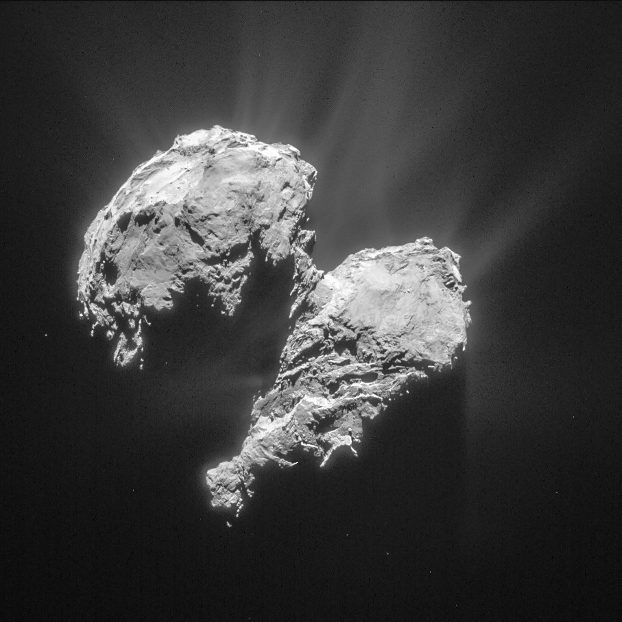
After a decade long chase of over 6.4 billion kilometers (4 Billion miles), ESA’s Rosetta spacecraft arrived at the pockmarked Comet 67P/Churyumov-Gerasimenko on Aug. 6, 2014 for history’s first ever attempt to orbit a comet for long term study.
Since then, Rosetta deployed the Philae landing craft to accomplish history’s first ever touchdown on a comets nucleus. It has also orbited the comet for over 10 months of up close observation, coming at times to as close as 8 kilometers. It is equipped with a suite 11 instruments to analyze every facet of the comet’s nature and environment.
Comet 67P is still becoming more and more active as it orbits closer and closer to the sun over the next two months. The pair reach perihelion on August 13, 2015 at a distance of 186 million km from the Sun, between the orbits of Earth and Mars.
Alice works by examining light emitted from the comet to understand the chemistry of the comet’s atmosphere, or coma and determine the chemical composition with the far-ultraviolet spectrograph.
According to the measurements from Alice, the water and carbon dioxide in the comet’s atmospheric coma originate from plumes erupting from its surface.
“It is similar to those that the Hubble Space Telescope discovered on Jupiter’s moon Europa, with the exception that the electrons at the comet are produced by solar radiation, while the electrons at Europa come from Jupiter’s magnetosphere,” said Paul Feldman, an Alice co-investigator from the Johns Hopkins University in Baltimore, Maryland, in a statement.
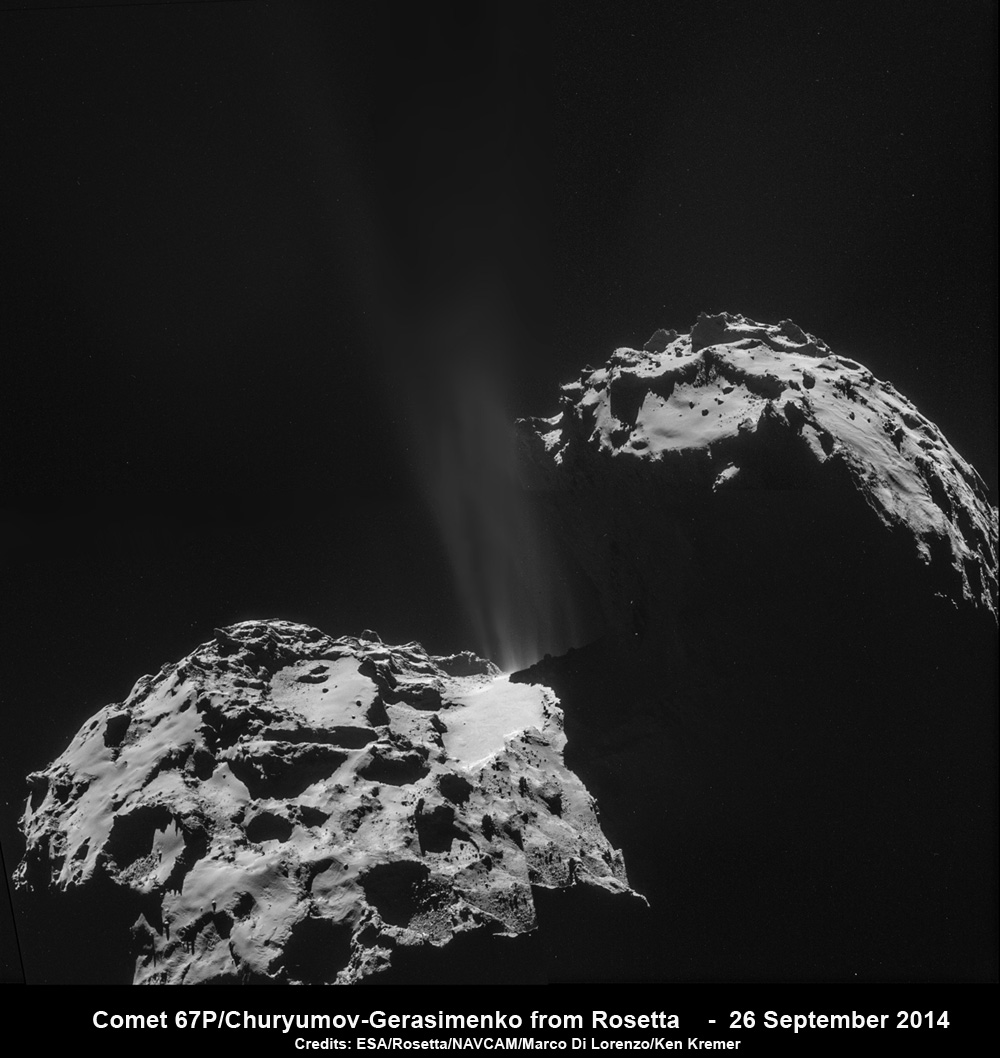
Rosetta discovered an unexpected process at comet nucleus that causes the rapid breakup of water and carbon dioxide molecules. Jets of gas and dust are blasting from the active neck of comet 67P/Churyumov-Gerasimenko in this photo mosaic assembled from four images taken on 26 September 2014 by the European Space Agency’s Rosetta spacecraft at a distance of 26.3 kilometers (16 miles) from the center of the comet. Credit: ESA/Rosetta/NAVCAM/Marco Di Lorenzo/Ken Kremer/kenkremer.com
Other instruments aboard Rosetta including MIRO, ROSINA and VIRTIS, which study relative abundances of coma constituents, corroborate the Alice findings.
“These early results from Alice demonstrate how important it is to study a comet at different wavelengths and with different techniques, in order to probe various aspects of the comet environment,” says ESA’s Rosetta project scientist Matt Taylor, in a statement.
“We’re actively watching how the comet evolves as it moves closer to the Sun along its orbit towards perihelion in August, seeing how the plumes become more active due to solar heating, and studying the effects of the comet’s interaction with the solar wind.”
Stay tuned here for Ken’s continuing Earth and planetary science and human spaceflight news.
NASA’s Martian Curiosity rover looks backs to 1000 Sols of science and exploration on the surface of the Red Planet. Robot wheel tracks lead back through valley dunes. Gale Crater rim seen in the distant hazy background. Sol 997 (May 28, 2015) navcam camera raw images stitched and colorized. Credit: NASA/JPL-Caltech/ Marco Di Lorenzo/Ken Kremer/kenkremer.com
Featured on APOD on June 13, 2015
Looking back 1000 Sols on the Red Planet
NASA’s Martian Curiosity rover looks backs to 1000 Sols of science and exploration on the surface of the Red Planet. Robot wheel tracks lead back through valley dunes. Gale Crater rim seen in the distant hazy background. Sol 997 (May 28, 2015) navcam camera raw images stitched and colorized. Credit: NASA/JPL-Caltech/ Marco Di Lorenzo/Ken Kremer/kenkremer.com Featured on APOD on June 13, 2015
Story updated[/caption]
The Martian Curiosity celebrates 1000 Sols on Mars!
Marking the occasion with utter glee, the car sized robot snapped a cool mosaic view (above) looking back to 1000 Sols of high impact exploration and discovery on the Red Planet, showing her wheel tracks leading back through valley dunes from the foothills of humongous Mount Sharp and across the alien surface floor and out to the distant rim of the Gale Crater landing site she descended to nearly three years ago in August 2012.
“A thousand thanks to the best team a rover could have. Celebrating 1,000 sols. Here’s to the Martian days ahead!” the robot tweeted.
But at 1K sols she’s not content to just bask in the Martian sunshine during the history making event. Rather, she is as always hard at work, reaching out with the high tech robotic arm and inspecting intriguing rock outcrops spread out all around her.
Check out Curiosity’s current workspace, looking back and hard at work in our new photo mosaics herein created by the imaging team of Marco Di Lorenzo and Ken Kremer. They are also featured at NBC News – here – and Alive Space Images (in Italian) – here and here.
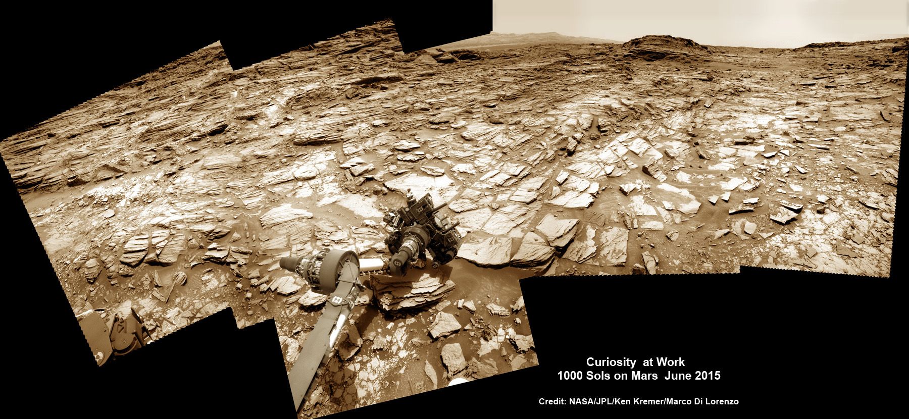
Curiosity rover at work for 1000 Sols on Mars
This composite multi sol photo mosaic shows outstretched robotic arm inspecting intriguing rock outcrops. The APXS spectrometer is investigating a target called ‘Ronan’ on the Stimson overlying outcrop. Navcam camera raw images taken from sols 997 to 1000 are stitched and colorized. Credit: NASA/JPL/Ken Kremer/kenkremer.com/Marco Di Lorenzo
The raw images for the look back mosaic were taken after she arrived at her current location on Martian Sol 997, or Earth’s Day May 28, 2015.
The Curiosity Mars Science Laboratory (MSL) rover officially celebrated 1000 Martian Sols on May 31, 2015 since she safely touched down on the crater floor on August 5, 2012 following the nail-biting and unprecedented sky crane maneuver that delivered her with pinpoint precision to a landing site nearby Mount Sharp.
“An MSL landmark day. We have reached 1000 sols on Mars. Looking back the remarkable thing is how few serious problems there have been,” says team member Professor John Bridges of the University of Leicester, England, in an update.
Exploring the sedimentary layers of Mount Sharp, which towers 3.4 miles (5.5 kilometers) into the Martian sky, form the primary destination and goal of her scientific expedition.
The six wheeled robot and her team of handlers back on Earth, are eeking out every last drop of science before she and all of Earth’s entire Martian invasion fleet enter solar conjunction, when Mars is behind the sun and little or no communications will be possible for most of the month of June. Activities will be limited per safety protocols.
“However, there is one issue even Curiosity can’t avoid – Conjunction. For much of June, Mars will be obscured from Earth by the Sun. Few science operations,” explains Bridges.
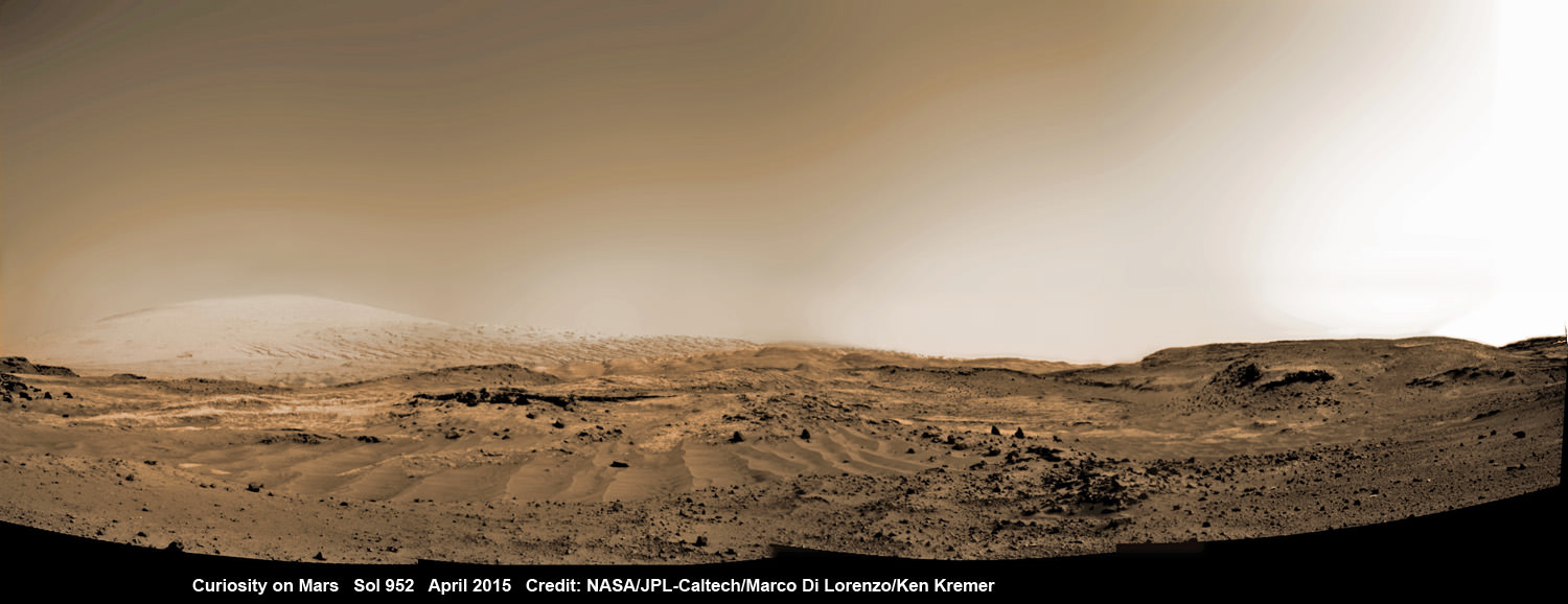
Curiosity rover rolls across Mars at the foothills of Mount Sharp, seen in the background, in this mosaic of images taken on April 11, 2015 (Sol 952). Navcam camera raw images stitched and colorized. Credit: NASA/JPL-Caltech/ Marco Di Lorenzo/Ken Kremer/kenkremer.com
After a short drive Curiosity arrived at her current location at “Marias Pass” on Sol 997, where she will stay stationary during the conjunction period out of an abundance of caution.
“A short bump on Sol 997 put Curiosity in a great position to investigate a few different rock units in Marias Pass, using the instruments on the rover’s arm,” wrote MSL and USGS mission scientist Ken Herkenhoff in an update.
She also reached within an eyelash of 10.6 kilometers (6.6 mi) of total driving.
“The 2.5 m drive brings our total odometry to 10,599 m,” noted Herkenoff.
Along the way she discovered the chemical ingredient minerals necessary to support life, as well as low levels of some organic molecules and some traces of methane, and and ample evidence for lakes and streams of liquid water.
“Curiosity is now parked for the next few weeks. But we are parked in front of a beautiful outcrop that shows the contact between the underlying Pahrump unit and the overlying Stimson unit.”
Our arm photo mosaic herein shows the seven foot (2 m) long robotic arm and its APXS spectrometer deployed at the target called “Ronan”, which is part of the overlying Stimson outcrop unit.
The rover is also using the ChemCam, MastCam and MAHLI cameras and spectrometers and other instruments to characterize the outcrop and its texture and composition in detail.
The robotic arm will be stowed during the June conjunction period.
Curiosity arrived at the Pahrump Hills at the base of Mount Sharp back in September 2014. Since then she has conducted an intensive investigation of the rocks and a trio of drilling operations to elucidate how this area fits in context with Mount Sharp and the habitable region discovered on the crater floor at Yellowknife Bay back in the spring of 2013.
In recent weeks, Curiosity has been driving up hills with slopes of as much as 21 degrees, higher than ever before, on an exciting journey endeavoring to slowly ascend up to the lower layers of Mount Sharp.
The current Martian outcrop area under investigation is a place where two distinctive geologic types of bedrock meet and where pale rock meets darker overlying rock.
“Such contacts can reveal clues about how the environmental conditions that produced one type of rock were related to the conditions that produced the other,” says NASA.
“The rover science team wants to examine an outcrop that contains the contact between the pale rock unit the mission analyzed lower on Mount Sharp and a darker, bedded rock unit that the mission has not yet examined up close.”
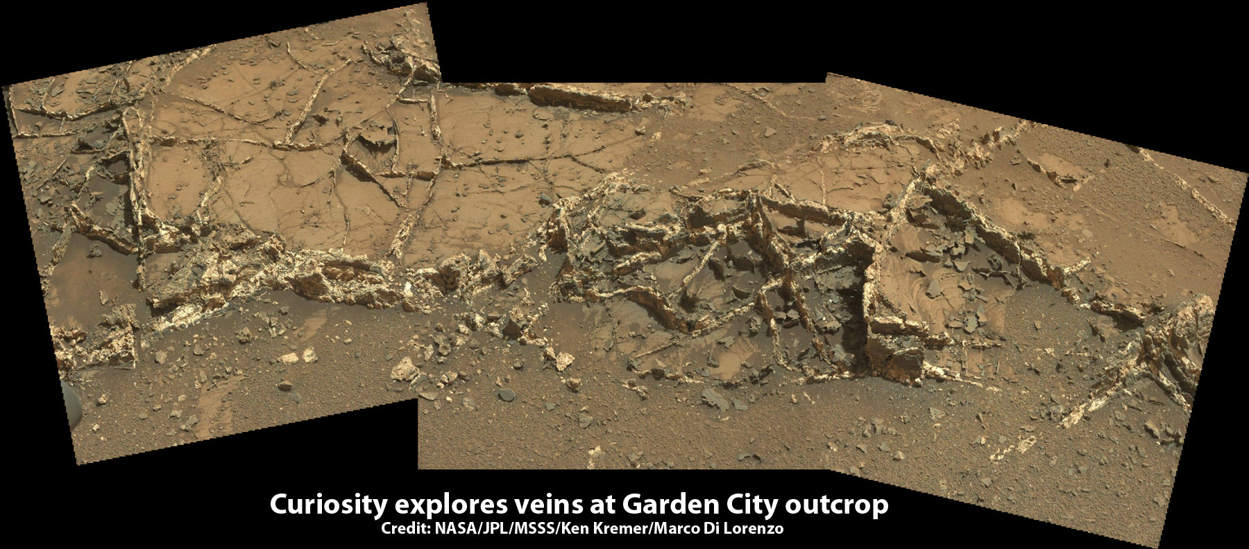
The team is also scouting around for the presence of mineral veins, like those recently discovered at the “Garden City” outcrop, that formed in the past during periods of flowing liquid water that could be favorable for microbial life forms if they ever existed.
Curiosity investigates a beautiful outcrop of scientifically enticing dark and light mineral veins at ”Garden City” outcrop at the base of Mount Sharp at current location on Mars. This photo mosaic was stitched from Mastcam color camera raw images. Credit: NASA/JPL-Caltech/MSSS/Ken Kremer/kenkremer.com/Marco Di Lorenzo
Because there’s a plethora of treacherous dunes, the team has had to monitor operations carefully and alter the route on occasion to maintain safe operations.
Curiosity has already accomplished her primary objective of discovering a habitable zone on the Red Planet that contains the minerals necessary to support microbial life in the ancient past when Mars was far wetter and warmer billions of years ago.
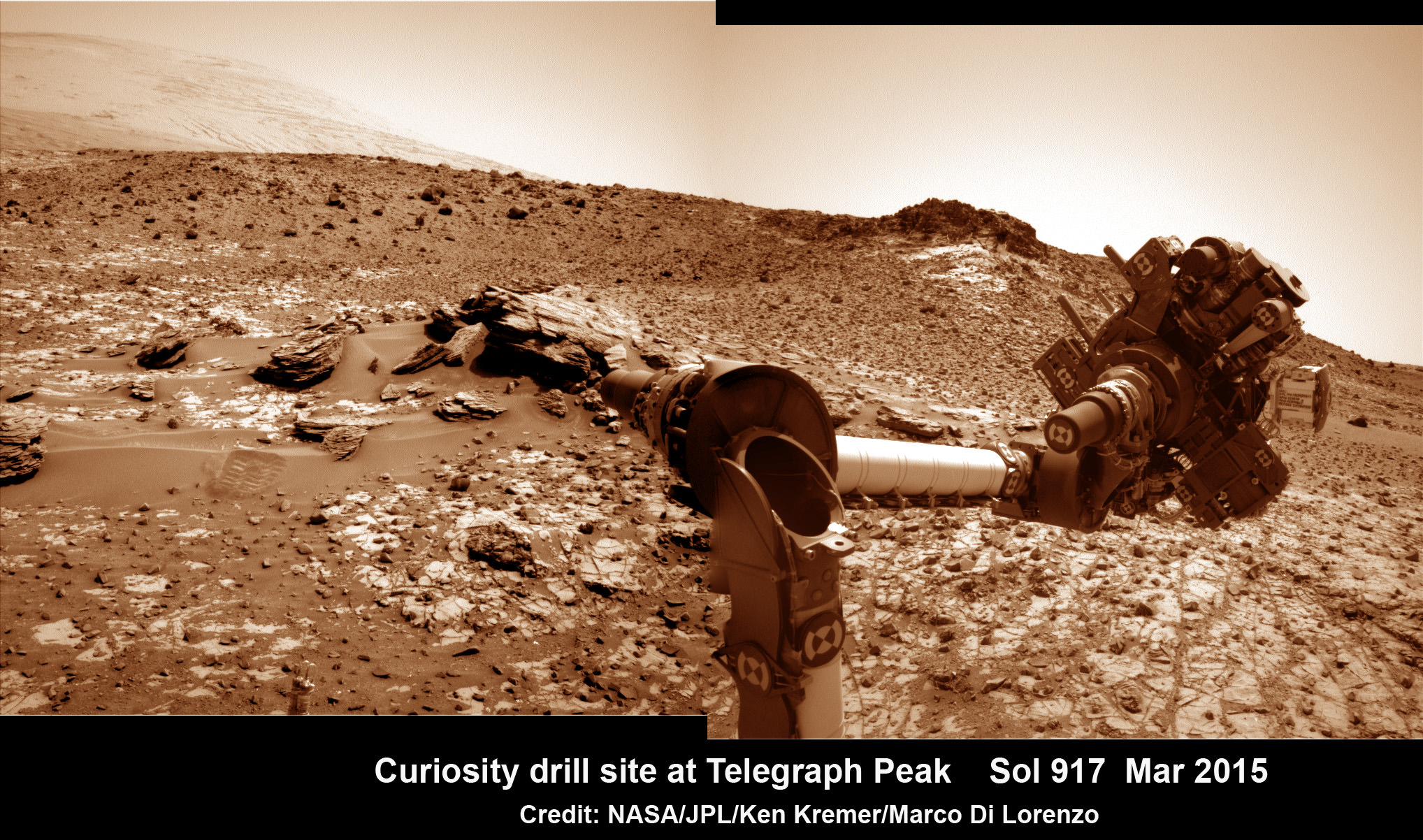
This March 6, 2015 (Sol 917), mosaic of images from the Navcam camera on NASA’s Curiosity Mars rover shows the position in which the rover held its arm for several days after a transient short circuit triggered onboard fault-protection programming to halt arm activities on Feb. 27, 2015, Sol 911. The rover team chose to hold the arm in the same position for several days of tests to diagnose the underlying cause of the Sol 911 event. Navcam camera raw images stitched and colorized. Credit: NASA/JPL-Caltech/Ken Kremer/kenkremer.com/Marco Di Lorenzo
To date, Curiosity’s odometer totals over 5.1 miles (8.4 kilometers) since landing inside Gale Crater on Mars in August 2012.
As of today, Sol 1001, June 1, 2015, she has taken over 246,000 amazing images.
Stay tuned here for Ken’s continuing Earth and planetary science and human spaceflight news.
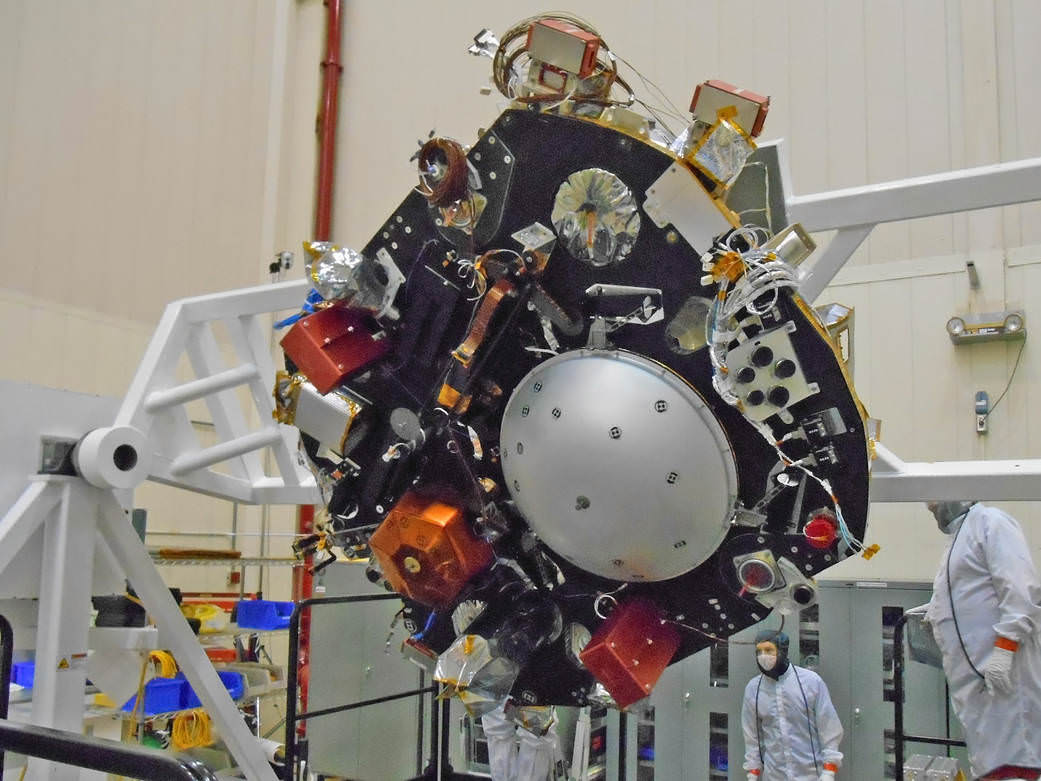
NASA's InSight Mars lander spacecraft in a Lockheed Martin clean room near Denver. As part of a series of deployment tests, the spacecraft was commanded to deploy its solar arrays in the clean room to test and verify the exact process that it will use on the surface of Mars. Credits: NASA/JPL-Caltech/Lockheed Martin
NASA’s ‘Journey to Mars’ is ramping up significantly with ‘InSight’ – as the agency’s next Red Planet lander has now been assembled into its flight configuration and begun a comprehensive series of rigorous and critical environmental stress tests that will pave the path to launch in 2016 on a mission to unlock the riddles of the Martian core.
The countdown clock is ticking relentlessly and in less than nine months time, NASA’s InSight Mars lander is slated to blastoff in March 2016.
InSight, which stands for Interior Exploration Using Seismic Investigations, Geodesy and Heat Transport, is a stationary lander. It will join NASA’s surface science exploration fleet currently comprising of the Curiosity and Opportunity missions which by contrast are mobile rovers.
But before it will even be allowed to get to the launch pad, the Red Planet explorer must first prove its mettle and show that it can operate in and survive the harsh and unforgiving rigors of the space environment via a battery of prelaunch tests. That’s an absolute requirement in order for it to successfully carry out its unprecedented mission to investigate Mars deep interior structure.
InSight’s purpose is to elucidate the nature of the Martian core, measure heat flow and sense for “Marsquakes.” These completely new research findings will radically advance our understanding of the early history of all rocky planets, including Earth and could reveal how they formed and evolved.
“Today, our robotic scientific explorers are paving the way, making great progress on the journey to Mars,” said Jim Green, director of NASA’s Planetary Science Division at the agency’s headquarters in Washington, in a statement.
“Together, humans and robotics will pioneer Mars and the solar system.”
The science deck of NASA’s InSight lander is being turned over in this April 29, 2015, photo from InSight assembly and testing operations inside a clean room at Lockheed Martin Space Systems, Denver. The large circular component on the deck is the protective covering to be placed over InSight’s seismometer after the seismometer is placed directly onto the Martian ground. Credits: NASA/JPL-Caltech/Lockheed Martin
The launch window for InSight opens on March 4 and runs through March 30, 2016.
InSight counts as NASA’s first ever interplanetary mission to launch from California.
The car sized probe will touch down near the Martian equator about six months later in the fall of 2016.
The prime contractor for InSight is Lockheed Martin Space Systems in Denver, Co and the engineering and technical team recently finished assembling the lander into its final configuration.
So now the time has begun to start the shakedown that literally involve “shaking and baking and zapping” the spacecraft to prove its ready and able to meet the March 2016 launch deadline.
During the next seven months of environmental testing at Lockheed’s Denver facility, “the lander will be exposed to extreme temperatures, vacuum conditions of nearly zero air pressure simulating interplanetary space, and a battery of other tests.”
“The assembly of InSight went very well and now it’s time to see how it performs,” said Stu Spath, InSight program manager at Lockheed Martin Space Systems, Denver, in a statement.
“The environmental testing regimen is designed to wring out any issues with the spacecraft so we can resolve them while it’s here on Earth. This phase takes nearly as long as assembly, but we want to make sure we deliver a vehicle to NASA that will perform as expected in extreme environments.”
The first test involves “a thermal vacuum test in the spacecraft’s “cruise” configuration, which will be used during its seven-month journey to Mars. In the cruise configuration, the lander is stowed inside an aeroshell capsule and the spacecraft’s cruise stage – for power, communications, course corrections and other functions on the way to Mars — is fastened to the capsule.”
After the vacuum test, InSight will be subjected to a series of tests simulating the vibrations of launch, separation and deployment shock, as well as checking for electronic interference between different parts of the spacecraft and compatibility testing.
Finally, a second thermal vacuum test will expose the probe “to the temperatures and atmospheric pressures it will experience as it operates on the Martian surface.”
The $425 million InSight mission is expected to operate for about two years on the Martian surface.
Artist rendition of NASA’s Mars InSight (Interior exploration using Seismic Investigations, Geodesy and Heat Transport) Lander. InSight is based on the proven Phoenix Mars spacecraft and lander design with state-of-the-art avionics from the Mars Reconnaissance Orbiter (MRO) and Gravity Recovery and Interior Laboratory (GRAIL) missions. Credit: JPL/NASA
InSight is an international science mission and a near duplicate of NASA’s successful Phoenix Mars landing spacecraft, Bruce Banerdt, InSight Principal Investigator of NASA’s Jet Propulsion Laboratory (JPL), Pasadena, California, told Universe Today.
“InSight is essentially built from scratch, but nearly build-to-print from the Phoenix design,” Banerdt, of NASA’s Jet Propulsion Laboratory (JPL) in Pasadena , Calif, told me. The team can keep costs down by re-using the blueprints pioneered by Phoenix instead of creating an entirely new spacecraft.
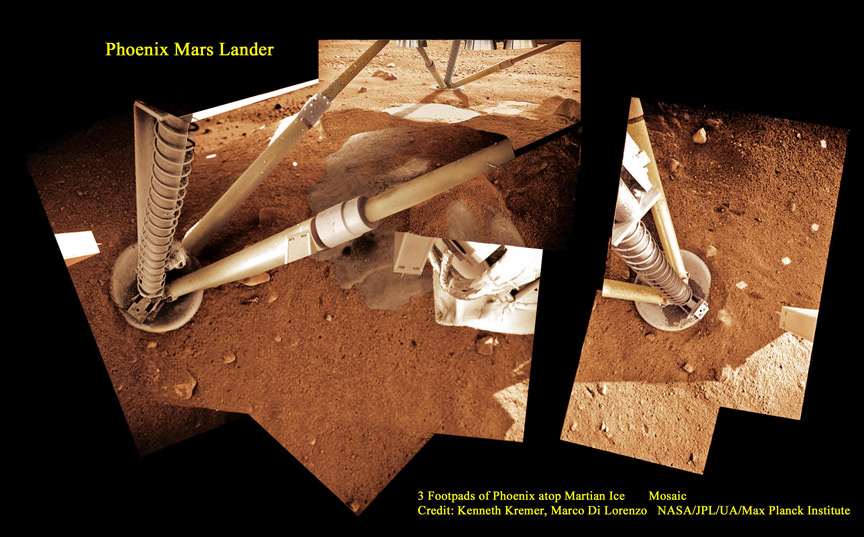
3 Footpads of Phoenix Mars Lander atop Martian Ice. NASA’s Mars InSight spacecraft design is based on the successful 2008 Phoenix lander. This mosaic shows Phoenix touchdown atop Martian ice. Phoenix thrusters blasted away Martian soil and exposed water ice. InSight carries instruments to peer deep into the Red Planet and investigate the nature and size of the mysterious Martian core. Credit: Ken Kremer/kenkremer.com/Marco Di Lorenzo/NASA/JPL/UA/Max Planck Institute
It is funded by NASA’s Discovery Program as well as several European national space agency’s and countries. Germany and France are providing InSight’s two main science instruments; HP3 and SEIS through the Deutsches Zentrum für Luft- und Raumfahrt. or German Aerospace Center (DLR) and the Centre National d’Etudes Spatiales (CNES).
“The seismometer (SEIS, stands for Seismic Experiment for Interior Structure) is from France (built by CNES and IPGP) and the heat flow probe (HP3, stands for Heat Flow and Physical Properties Probe) is from Germany (built by DLR),” Banerdt explained.
SEIS and HP3 are stationed on the lander deck. They will each be picked up and deployed by a robotic arm similar to that flown on Phoenix with some modifications.
Stay tuned here for Ken’s continuing Earth and planetary science and human spaceflight news.
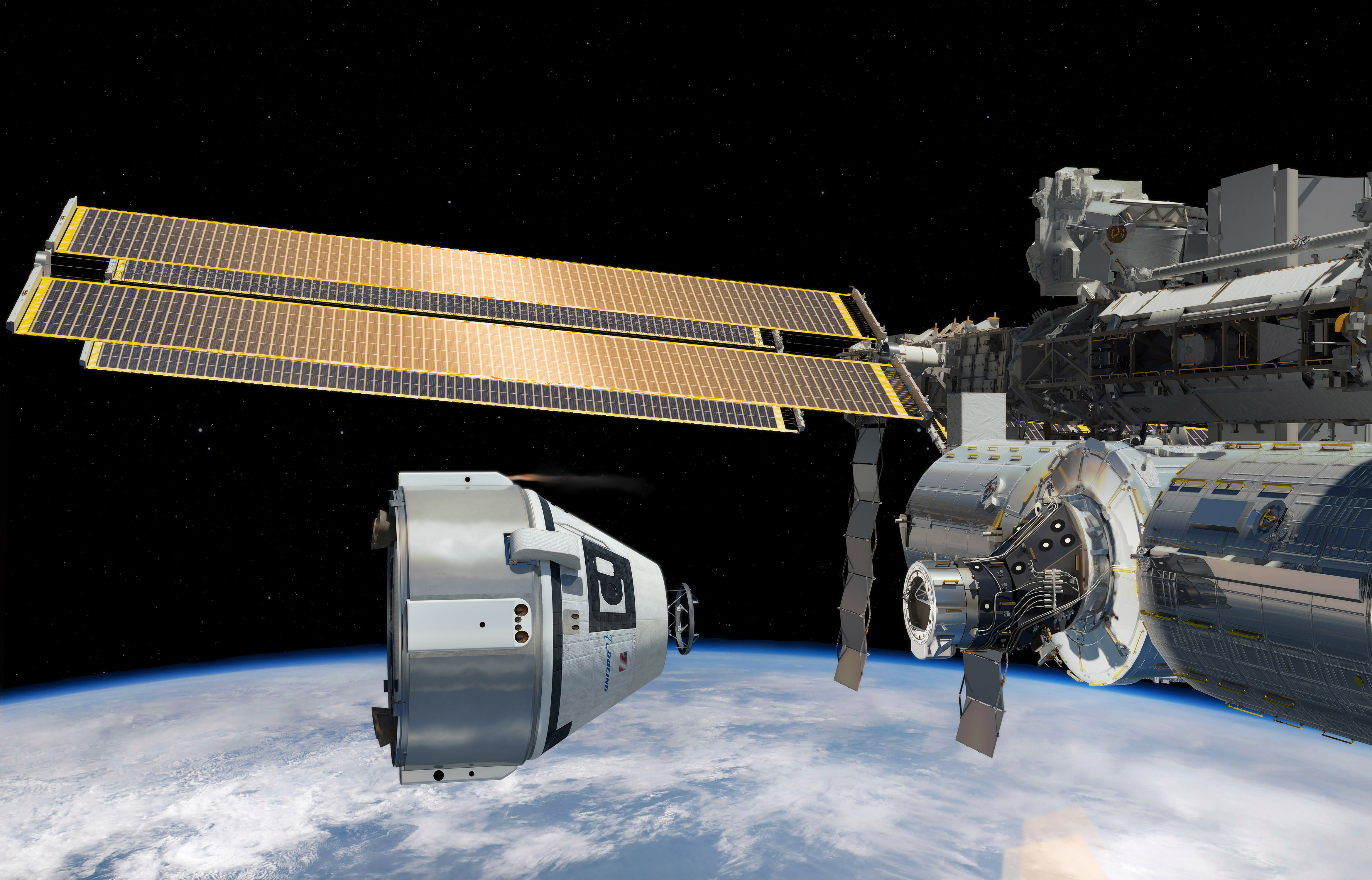
Boeing was awarded the first service flight of the CST-100 crew capsule to the International Space Station as part of the Commercial Crew Transportation Capability agreement with NASA in this artists concept. Credit: Boeing
NASA’s Commercial Crew Program (CCP) office gave the first commercial crew rotation mission award to the Boeing Company to launch its CST-100 astronaut crew capsule to the ISS by late 2017, so long as the company satisfactorily meets all of NASA’s human spaceflight certification milestones.
Thus begins the history making new era of commercial human spaceflight.
“This occasion will go in the books of Boeing’s nearly 100 years of aerospace and more than 50 years of space flight history,” said John Elbon, vice president and general manager of Boeing’s Space Exploration division, in a statement.
“We look forward to ushering in a new era in human space exploration.”
Boeing was awarded a $4.2 Billion contract in September 2014 by NASA Administrator Charles Bolden to complete development and manufacture of the CST-100 ‘space taxi’ under the agency’s Commercial Crew Transportation Capability (CCtCap) program and NASA’s Launch America initiative.
“Final development and certification are top priority for NASA and our commercial providers, but having an eye on the future is equally important to the commercial crew and station programs,” said Kathy Lueders, manager of NASA’s Commercial Crew Program.
“Our strategy will result in safe, reliable and cost-effective crew missions.”
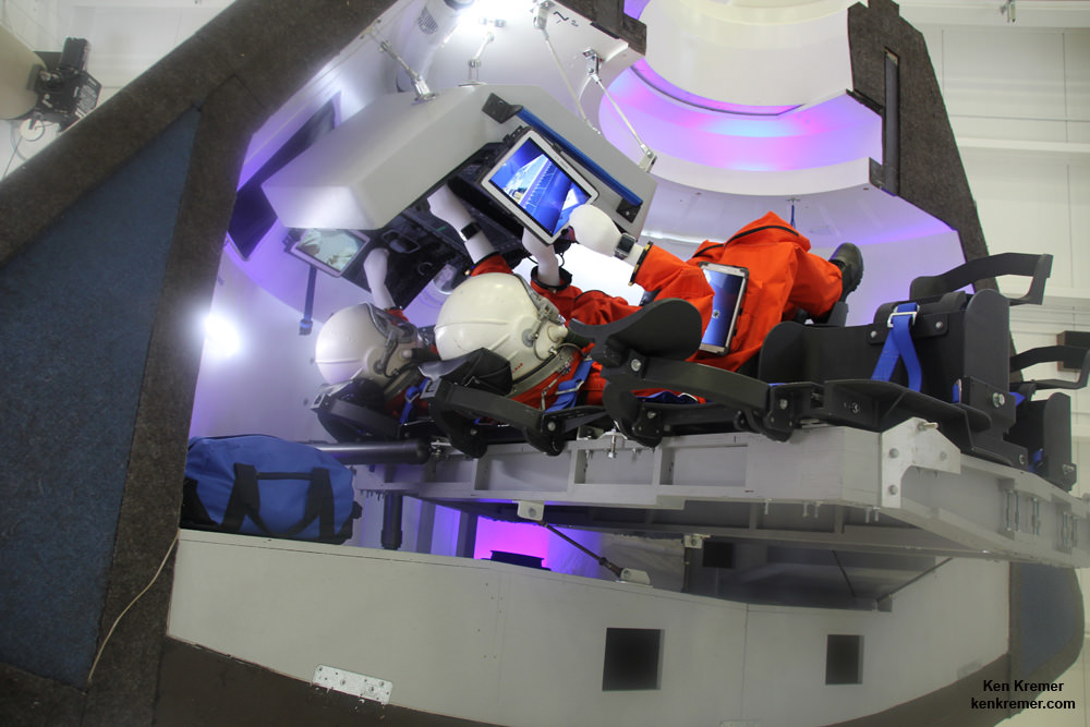
Boeing CST-100 crew capsule will carry four to seven person crews to the ISS. Credit: Ken Kremer – kenkremer.com
The CST-100 will be carried to low Earth orbit atop a manrated United Launch AllianceAtlas V rocket launching from Cape Canaveral Air Force Station, Florida.
Boeing will first conduct a pair of unmanned and manned orbital CST-100 test flights earlier in 2017 in April and July, prior to the operational commercial crew rotation mission to confirm that their capsule is ready and able and met all certification milestone requirements set by NASA.
“Orders under the CCtCap contracts are made two to three years prior to the missions to provide time for each company to manufacture and assemble the launch vehicle and spacecraft. In addition, each company must successfully complete the certification process before NASA will give the final approval for flight,” says NASA.
Boeing got the mission order from NASA because they have “successfully demonstrated to NASA that the Commercial Crew Transportation System has reached design maturity appropriate to proceed to assembly, integration and test activities.”
Boeing recently completed the fourth milestone in the CCtCap phase dubbed the delta integrated critical design review.
Read my earlier exclusive, in depth one-on-one interviews with Chris Ferguson – America’s last shuttle commander and who now leads Boeings CST-100 program; here and here.
The commercial crew program is designed to return human spaceflight launches to the United States and end our sole source reliance on Russia and the Soyuz capsule.
Since the forced retirement of NASA’s shuttle orbiters in 2011, US astronauts have been totally dependent on the Russians for trips to space and back.
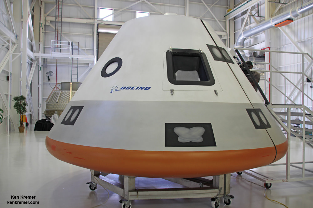
Boeing unveiled full scale mockup of their commercial CST-100 ‘Space Taxi’ on June 9, 2014 at its intended manufacturing facility at the Kennedy Space Center in Florida. The private vehicle will launch US astronauts to low Earth orbit and the ISS from US soil. Credit: Ken Kremer – kenkremer.com
SpaceX also received a NASA award worth $2.6 Billion to build the Crew Dragon spacecraft for launch atop the firms man-rated Falcon 9 rocket.
NASA will order a commercial mission from SpaceX sometime later this year. At a later date NASA will decide which company will fly the first commercial crew rotation mission to the ISS.
Both the CST-100 and Crew Dragon will typically carry a crew of four or five NASA or NASA-sponsored crew members, along with some 220 pounds of pressurized cargo. Each will also be capable of carrying up to seven crew members depending on how the capsule is configured.
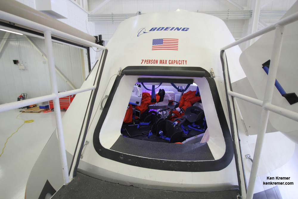
Hatch opening to Boeing’s commercial CST-100 crew transporter. Credit: Ken Kremer – kenkremer.com
The spacecraft will be capable to remaining docked at the station for up to 210 days and serve as an emergency lifeboat during that time.
The NASA CCtCAP contracts call for a minimum of two and a maximum potential of six missions from each provider.
The station crew will also be enlarged to seven people that will enable a doubling of research time.
“Commercial Crew launches are critical to the International Space Station Program because it ensures multiple ways of getting crews to orbit,” said Julie Robinson, International Space Station chief scientist.
“It also will give us crew return capability so we can increase the crew to seven, letting us complete a backlog of hands-on critical research that has been building up due to heavy demand for the National Laboratory.”
NASA’s Commercial Crew Program initiative aims to restore US access to the ISS. Credit: NASA
Stay tuned here for Ken’s continuing Earth and planetary science and human spaceflight news.
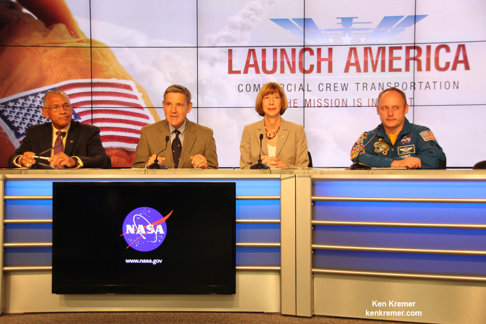
NASA Administrator Charles Bolden (left) announces the winners of NASA’s Commercial Crew Program development effort to build America’s next human spaceships launching from Florida to the International Space Station. Speaking from Kennedy’s Press Site, Bolden announced the contract award to Boeing and SpaceX to complete the design of the CST-100 and Crew Dragon spacecraft. Former astronaut Bob Cabana, center, director of NASA’s Kennedy Space Center in Florida, Kathy Lueders, manager of the agency’s Commercial Crew Program, and former International Space Station Commander Mike Fincke also took part in the announcement. Credit: Ken Kremer- kenkremer.com
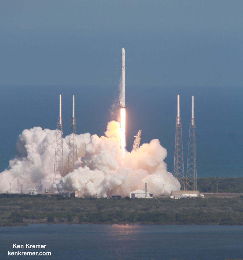
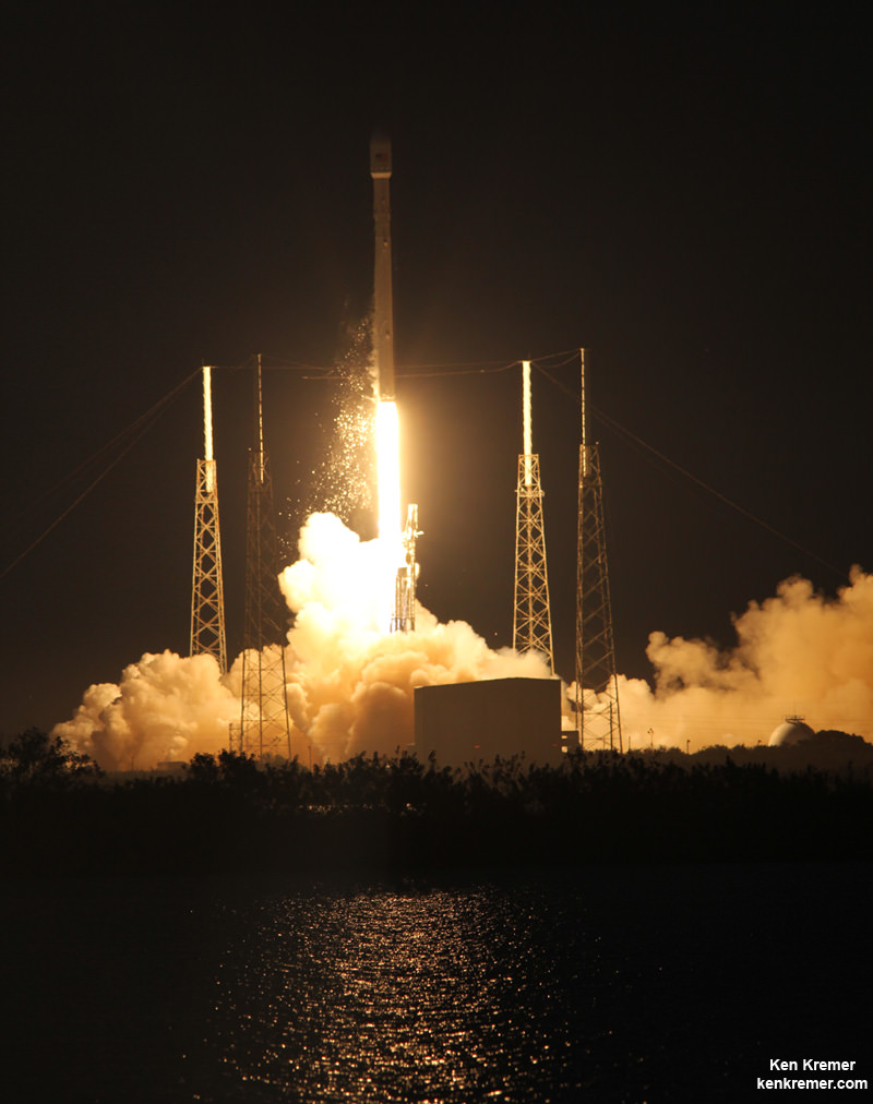
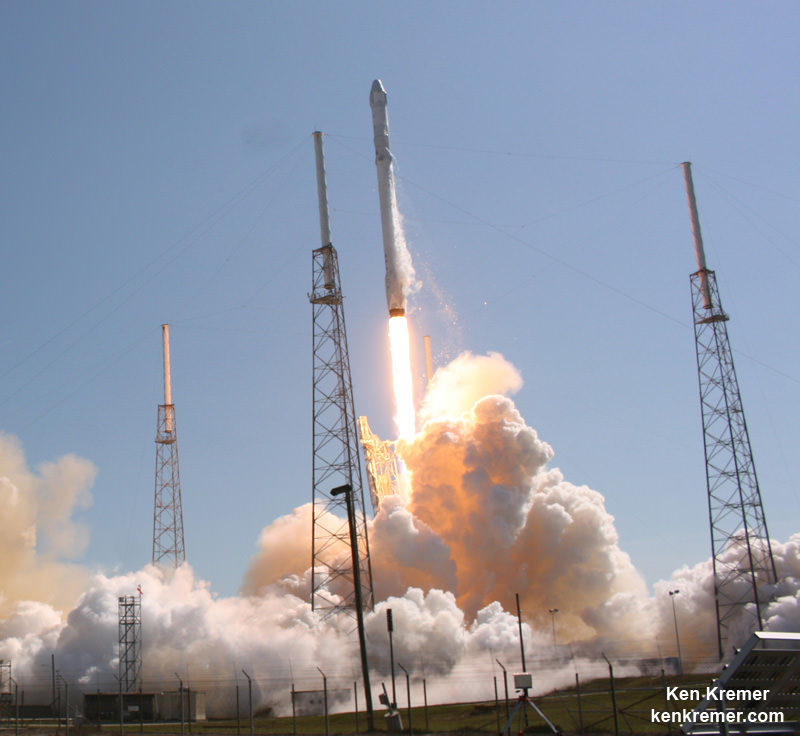
SpaceX Falcon 9 and Dragon blastoff from Space Launch Complex 40 at Cape Canaveral Air Force Station in Florida on April 14, 2015 at 4:10 p.m. EDT on the CRS-6 mission to the International Space Station. Credit: Ken Kremer/kenkremer.com
SpaceX Falcon 9 is now certified for USAF launches. SpaceX Falcon 9 and Dragon blastoff from Space Launch Complex 40 at Cape Canaveral Air Force Station in Florida on April 14, 2015 at 4:10 p.m. EDT on the CRS-6 mission to the International Space Station. Credit: Ken Kremer/kenkremer.com
Story updated[/caption]
The U.S. Air Force announced Tuesday that they have certified SpaceX to launch the nations critical and highly valuable national security satellites on the firms Falcon 9 rocket, thereby breaking the decade old launch monopoly held by launch competitor United Launch Alliance (ULA). ULA is a joint venture owned by aerospace giants Boeing and Lockheed Martin.
The Air Force’s goal in approving the SpaceX Falcon 9 booster is aimed at drastically cutting the high cost of access to space by introducing competition in the awarding of military mission launch contacts. The prior contract involved a sole source $11 Billion “block buy” bid for 36 rocket cores from ULA in December 2013 which was legally challenged by SpaceX in April 2014, but eventually settled by SpaceX in an agreement with the USAF earlier this year.
Lieutenant General Samuel Greaves, Commander of the Air Force Space and Missile Systems Center (SMC), announced the long awaited decision on Tuesday, May 26.
The certification milestone came after a grueling two year review process in which the Air Force invested more than $60 million and 150 people to thoroughly review all aspects of the Falcon 9 booster. The review was based on three successful flights by the Falcon 9 v1.1 which first launched in late 2013.
The purpose of certification is to assure that qualified launch providers could meet the challenge of safely, securely and reliably lofting expensive U.S. national security military missions to space and into their intended orbits with full mission capability that are critical for maintaining national defense.
“The SpaceX and SMC teams have worked hard to achieve certification,” said Greaves, Commander of the Air Force Space and Missile Systems Center (SMC) and Air Force Program Executive Officer for Space, in a statement.
“And we’re also maintaining our spaceflight worthiness process supporting the National Security Space missions. Our intent is to promote the viability of multiple EELV-class launch providers as soon as feasible.”
And the competitive launch races “for award of qualified national security space launch missions” between SpaceX and ULA start very soon, within the next month says the USAF.
In June, the Air Force will issue a Request for Proposal (RFP) for GPS III launch services. ULA has three GPS launches in its manifest for 2015.
Of course SpaceX was overjoyed on hearing the certification news.
“This is an important step toward bringing competition to National Security Space launch, said Elon Musk, SpaceX CEO and Lead Designer.
‘We thank the Air Force for its confidence in us and look forward to serving it well.”
Until today, ULA has held a launch monopoly over military missions since the company was founded in 2006. ULA also launches many NASA science missions, but very few commercial satellites.
Thus the U.S. military and NASA provide the core of ULA’s business and the source of much of its income and profits.
SpaceX is now certified by the Air Force for the right to compete for US national security satellites launches using Falcon 9 rockets such as this one which successfully launched the SES-8 communications satellite on Dec. 3, 2013 from Pad 40 at Cape Canaveral, FL. Credit: Ken Kremer/kenkremer.com
“This is a very important milestone for the Air Force and the Department of Defense,” said Secretary of the Air Force Deborah Lee James, in a statement.
“SpaceX’s emergence as a viable commercial launch provider provides the opportunity to compete launch services for the first time in almost a decade. Ultimately, leveraging of the commercial space market drives down cost to the American taxpayer and improves our military’s resiliency.”
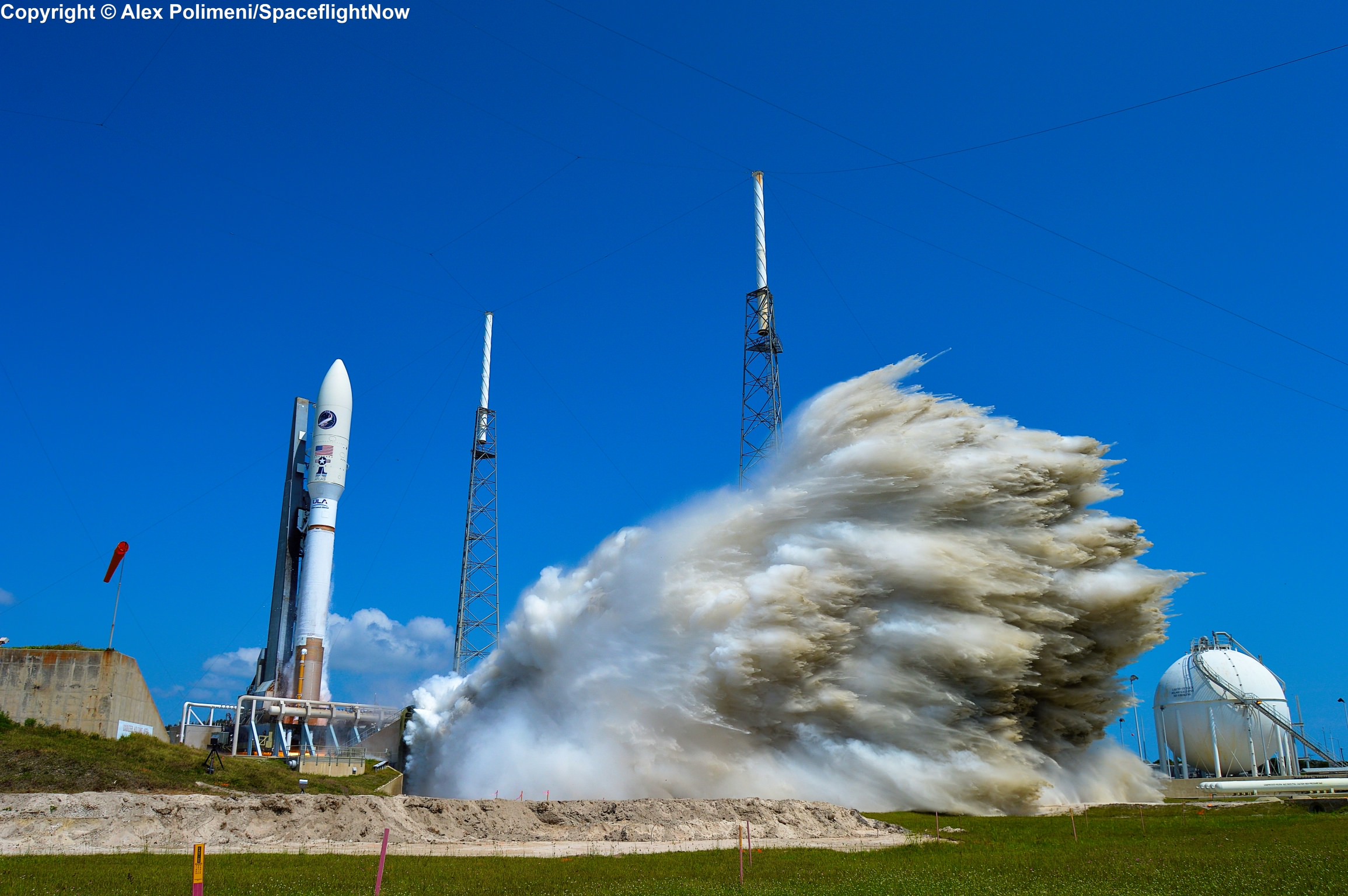
Other military spacecraft in the future could involve vehicles such as the X-37B space plane which recently launched on an Atlas V, as well as weather satellites, signals intelligence and missile warning satellites and a range of top secret missions for the National Reconnaissance Office (NRO) that have been routinely launched by ULA with a 100% success rate to date.
USAF X-37B orbital test vehicle launches atop United Launch Alliance Atlas V rocket on May 20, 2015 on OTV-4 mission. Credit: Alex Polimeni
ULA’s stable of launchers includes the Atlas V and Delta IV families of vehicles. ULA is phasing out the Delta IV due to its high costs. Only the Delta IV Heavy will remain in service as required to launch the very heaviest satellites that cannot be accommodated by less powerful rockets.
ULA is also replacing the Atlas V with the partly reusable new Vulcan rocket, that will be phased in starting in 2019 using American-made engines from either Blue Origin or Aerojet Rocketdyne.
The Atlas V uses Russian made RD-180 engines, who’s use has become highly contentious since the deadly crisis in Ukraine erupted in 2014.
The ensuing threats of RD-180 engine embargoes and imposition of sanctions and counter sanctions imposed by the US and Russia have thus placed US national security at risk by being dependent on a rocket with foreign made engines whose future supply chain was uncertain.
U.S. Senator John McCain (R-AZ), Chairman of the Senate Armed Services Committee, has been highly critical of the ULA dependence on the Russian RD-180 engines and issued this statement in response to the Air Force announcement.
“The certification of SpaceX as a provider for defense space launch contracts is a win for competition, said McCain.
“Over the last 15 years, as sole-source contracts were awarded, the cost of EELV was quickly becoming unjustifiably high. I am hopeful that this and other new competition will help to bring down launch costs and end our reliance on Russian rocket engines that subsidizes Vladimir Putin and his cronies.”
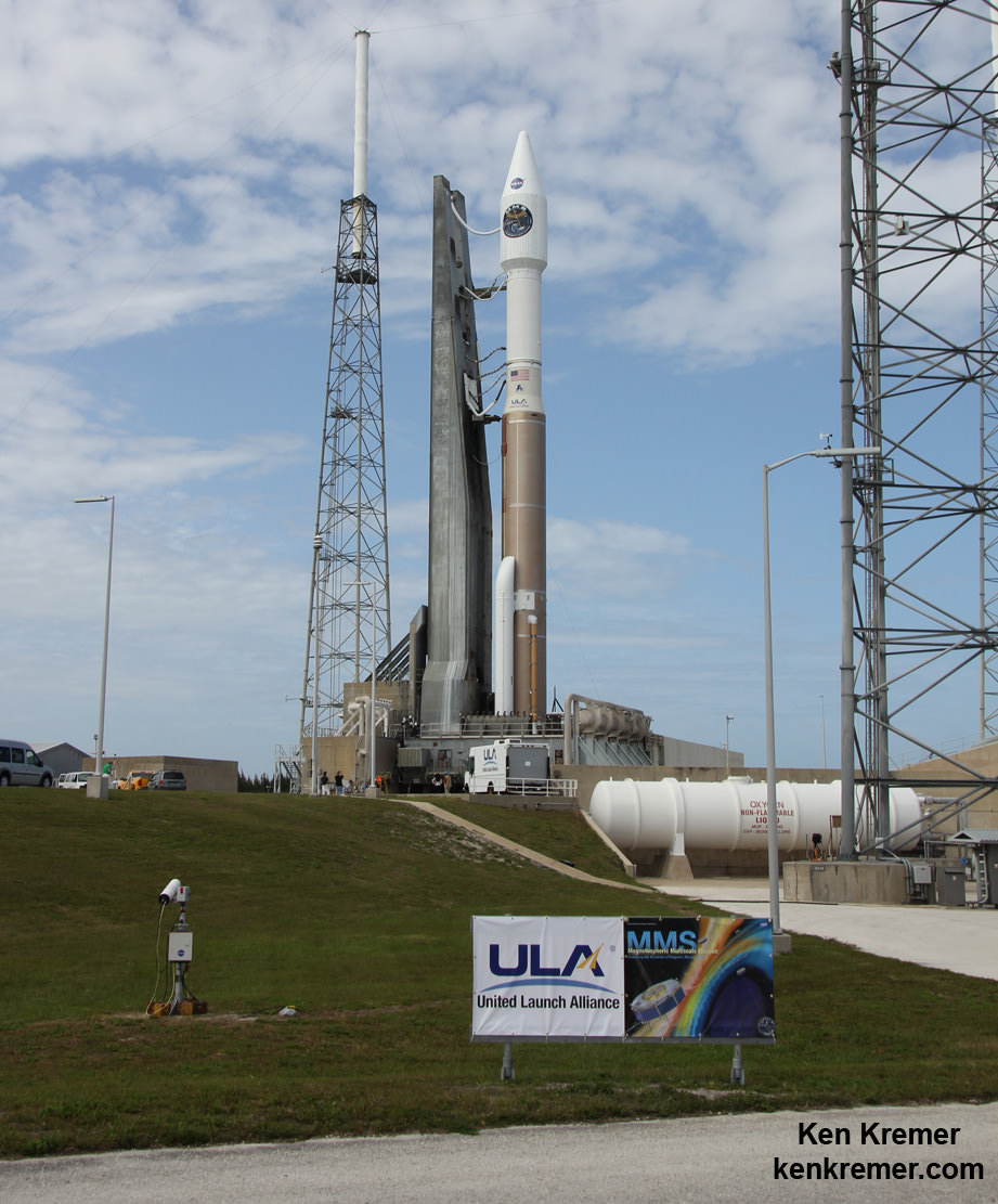
A United Launch Alliance Atlas V 421 rocket is poised for blastoff at Cape Canaveral Air Force Station’s Space Launch Complex-41 in preparation for launch of NASA’s Magnetospheric Multiscale (MMS) science mission on March 12, 2015. Credit: Ken Kremer- kenkremer.com
Overall the Air Force “invested more than $60 million and 150 people in the certification effort which encompassed 125 certification criteria, including more than 2,800 discreet tasks, 3 certification flight demonstrations, verifying 160 payload interface requirements, 21 major subsystem reviews and 700 audits in order to establish the technical baseline from which the Air Force will make future flight worthiness determinations for launch.”
Stay tuned here for Ken’s continuing Earth and planetary science and human spaceflight news.
SpaceX Falcon 9 and Dragon blastoff from Space Launch Complex 40 at Cape Canaveral Air Force Station in Florida on April 14, 2015 at 4:10 p.m. EDT on the CRS-6 mission to the International Space Station. Credit: Ken Kremer/kenkremer.com
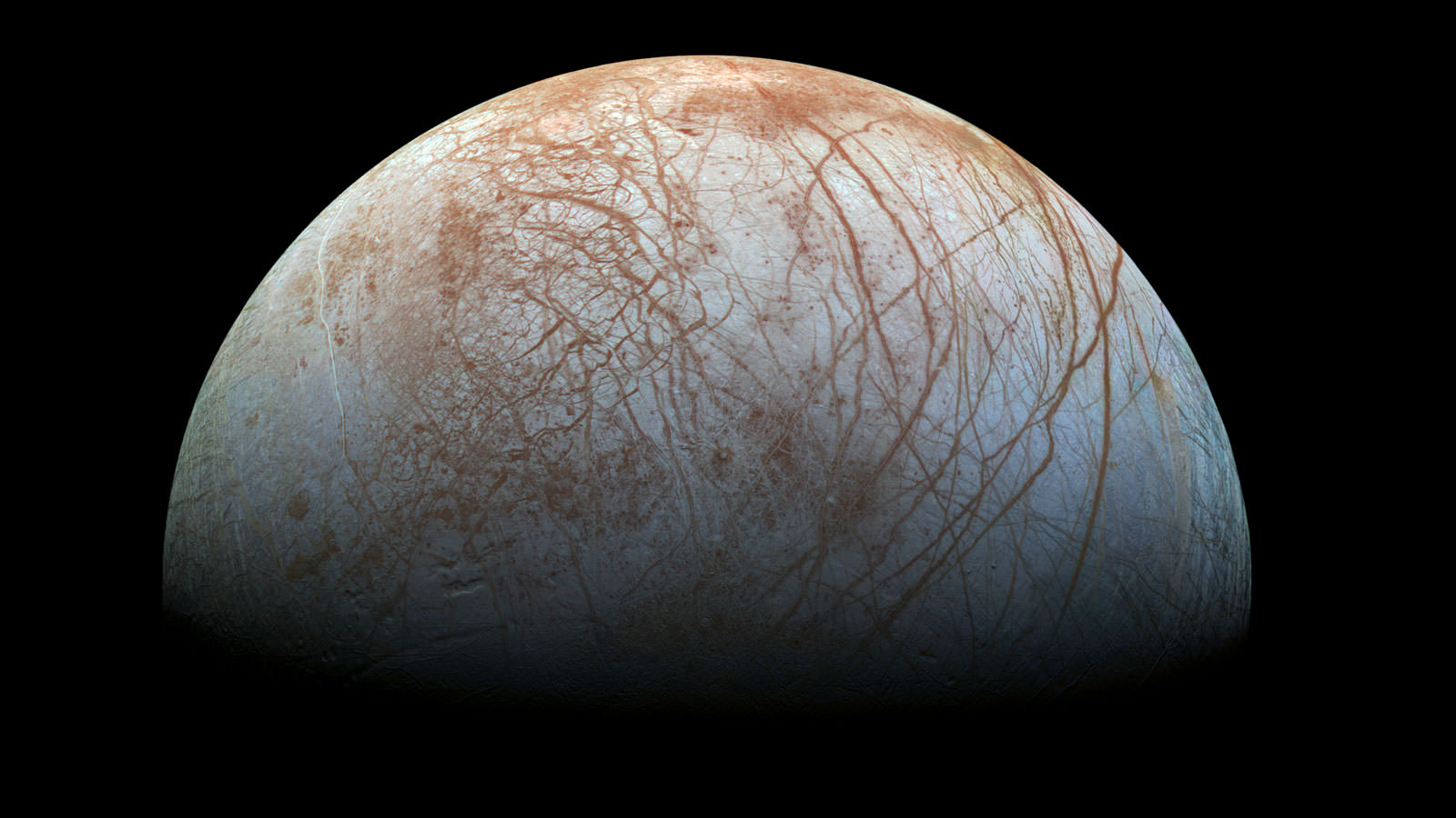
The fascinating surface of Jupiter’s icy moon Europa looms large in this newly-reprocessed color view, made from images taken by NASA's Galileo spacecraft in the late 1990s. This is the color view of Europa from Galileo that shows the largest portion of the moon's surface at the highest resolution. Credits: NASA/JPL-Caltech/SETI Institute
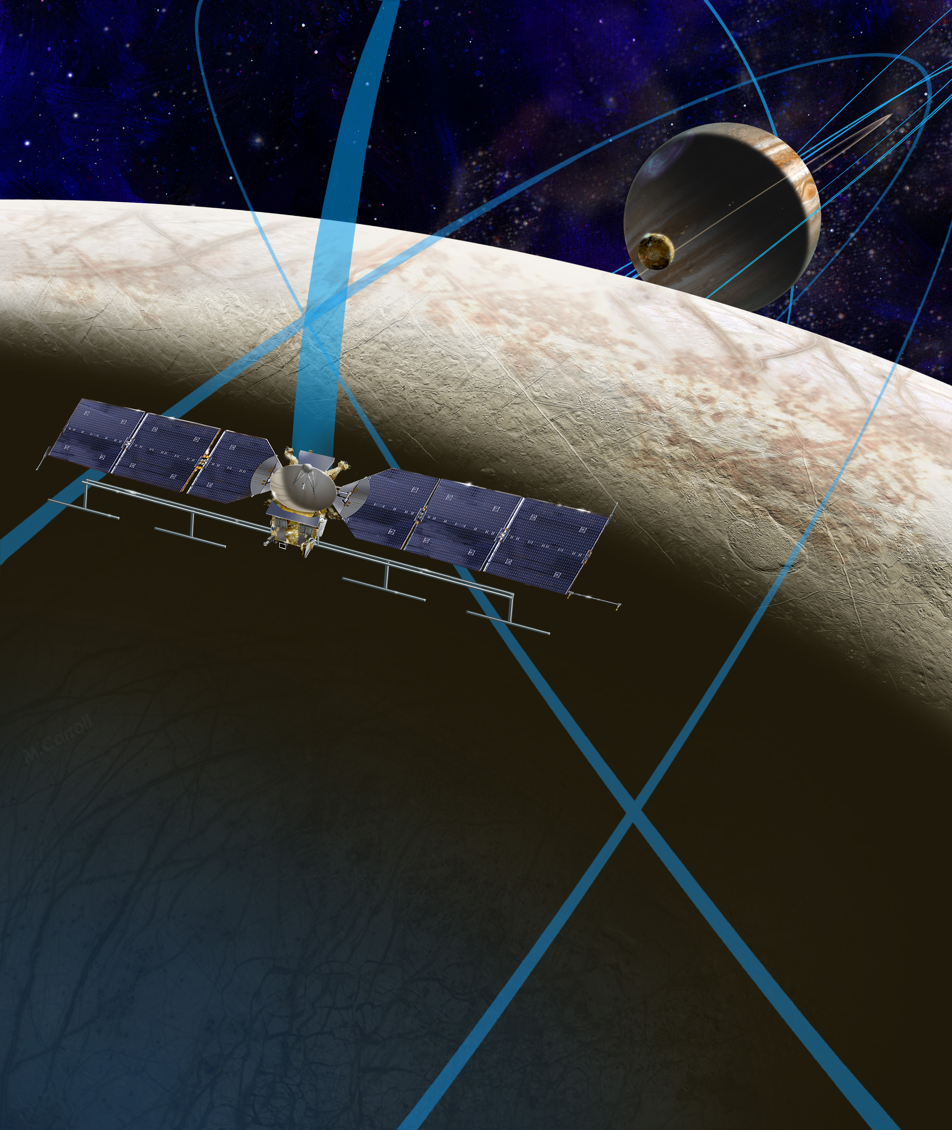
In a major move forward on a long dreamed of mission to investigate the habitability of the subsurface ocean of Jupiter’s mysterious moon Europa, top NASA officials announced today, Tuesday, May 26, the selection of nine science instruments that will fly on the agency’s long awaited planetary science mission to an intriguing world that many scientists suspect could support life.
“We are on our way to Europa,” proclaimed John Grunsfeld, associate administrator for NASA’s Science Mission Directorate in Washington, at a media briefing today outlining NASA’s plans for a mission dedicated to launching in the early to mid-2020s. “It’s a mission to inspire.”
“We are trying to answer big questions. Are we alone?”
“The young surface seems to be in contact with an undersea ocean.”
The Europa mission goal is to investigate whether the tantalizing icy Jovian moon, similar in size to Earth’s moon, could harbor conditions suitable for the evolution and sustainability of life in the suspected ocean.
It will be equipped with high resolution cameras, radar and spectrometers, several generations beyond anything before to map the surface in unprecedented detail and determine the moon’s composition and subsurface character. And it will search for subsurface lakes and seek to sample erupting vapor plumes like those occurring today on Saturn’s tiny moon Enceladus.
“Europa has tantalized us with its enigmatic icy surface and evidence of a vast ocean, following the amazing data from 11 flybys of the Galileo spacecraft over a decade ago and recent Hubble observations suggesting plumes of water shooting out from the moon,” says Grunsfeld.
“We’re excited about the potential of this new mission and these instruments to unravel the mysteries of Europa in our quest to find evidence of life beyond Earth.”
Planetary scientists have long desired a speedy return on Europa, ever since the groundbreaking discoveries of NASA’s Galileo Jupiter orbiter in the 1990s showed that the alien world possessed a substantial and deep subsurface ocean beneath an icy shell that appears to interact with and alter the surface in recent times.
This 12-frame mosaic provides the highest resolution view ever obtained of the side of Jupiter’s moon Europa that faces the giant planet. It was obtained on Nov. 25, 1999 by the camera onboard the Galileo spacecraft, a past NASA mission to Jupiter and its moons. Credit: NASA/JPL/University of Arizona
NASA’s Europa mission would blastoff perhaps as soon as 2022, depending on the budget allocation and rocket selection, whose candidates include the heavy lift Space Launch System (SLS).
The solar powered probe will go into orbit around Jupiter for a three year mission.
“The mission concept is that it will conduct multiple flyby’s of Europa,” said Jim Green. director, Planetary Science Division, NASA Headquarters, during the briefing.
“The purpose is to determine if Europa is a habitable place. It shows few craters, a brown gum on the surface and cracks where the subsurface meet the surface. There may be organics and nutrients among the discoloration at the surface.”
Europa is at or near the top of the list for most likely places in our solar system that could support life. Mars is also near the top of the list and currently being explored by a fleet of NASA robotic probes including surface rovers Curiosity and Opportunity.
“Europa is one of those critical areas where we believe that the environment is just perfect for potential development of life,” said Green. “This mission will be that step that helps us understand that environment and hopefully give us an indication of how habitable the environment could be.”
The exact thickness of Europa’s ice shell and extent of its subsurface ocean is not known.
The ice shell thickness has been inferred by some scientists to be perhaps only 5 to 10 kilometers thick based on data from Galileo, the Hubble Space Telescope, a Cassini flyby and other ground and space based observations.
The global ocean might be twice the volume of all of Earth’s water. Research indicates that it is salty, may possess organics, and has a rocky sea floor. Tidal heating from Jupiter could provide the energy for mixing and chemical reactions, supplemented by undersea volcanoes spewing heat and minerals to support living creatures, if they exist.
This artist’s rendering shows a concept for a future NASA mission to Europa in which a spacecraft would make multiple close flybys of the icy Jovian moon, thought to contain a global subsurface ocean. Credits: NASA/JPL-Caltech
“Europa could be the best place in the solar system to look for present day life beyond our home planet,” says NASA officials.
The instruments chosen today by NASA will help answer the question of habitability, but they are not life detection instruments in and of themselves. That would require a follow on mission.
“They could find indications of life, but they’re not life detectors,” said Curt Niebur, Europa program scientist at NASA Headquarters in Washington. “We currently don’t even have consensus in the scientific community as to what we would measure that would tell everybody with confidence this thing you’re looking at is alive. Building a life detector is incredibly difficult.”
‘During the three year mission, the orbiter will conduct 45 close flyby’s of Europa,” Niebur told Universe Today. “These will occur about every two to three weeks.”
The close flyby’s will vary in altitude from 16 miles to 1,700 miles (25 kilometers to 2,700 kilometers).
“The mass spectrometer has a range of 1 to 2000 daltons, Niebur told me. “That’s a much wider range than Cassini. However there will be no means aboard to determine chirality.” The presence of Chiral compounds could be an indicator of life.
Right now the Europa mission is in the formulation stage with a budget of about $10 million this year and $30 Million in 2016. Over the next three years the mission concept will be defined.
The mission is expected to cost in the range of at least $2 Billion or more.
Jupiter Moon Europa, Ice Rafting View
Here’s a NASA description of the 9 instruments selected:
Plasma Instrument for Magnetic Sounding (PIMS) — principal investigator Dr. Joseph Westlake of Johns Hopkins Applied Physics Laboratory (APL), Laurel, Maryland. This instrument works in conjunction with a magnetometer and is key to determining Europa’s ice shell thickness, ocean depth, and salinity by correcting the magnetic induction signal for plasma currents around Europa.
Interior Characterization of Europa using Magnetometry (ICEMAG) — principal investigator Dr. Carol Raymond of NASA’s Jet Propulsion Laboratory (JPL), Pasadena, California. This magnetometer will measure the magnetic field near Europa and – in conjunction with the PIMS instrument – infer the location, thickness and salinity of Europa’s subsurface ocean using multi-frequency electromagnetic sounding.
Mapping Imaging Spectrometer for Europa (MISE) — principal investigator Dr. Diana Blaney of JPL. This instrument will probe the composition of Europa, identifying and mapping the distributions of organics, salts, acid hydrates, water ice phases, and other materials to determine the habitability of Europa’s ocean.
Europa Imaging System (EIS) — principal investigator Dr. Elizabeth Turtle of APL. The wide and narrow angle cameras on this instrument will map most of Europa at 50 meter (164 foot) resolution, and will provide images of areas of Europa’s surface at up to 100 times higher resolution.
Radar for Europa Assessment and Sounding: Ocean to Near-surface (REASON) — principal investigator Dr. Donald Blankenship of the University of Texas, Austin. This dual-frequency ice penetrating radar instrument is designed to characterize and sound Europa’s icy crust from the near-surface to the ocean, revealing the hidden structure of Europa’s ice shell and potential water within.
Europa Thermal Emission Imaging System (E-THEMIS) — principal investigator Dr. Philip Christensen of Arizona State University, Tempe. This “heat detector” will provide high spatial resolution, multi-spectral thermal imaging of Europa to help detect active sites, such as potential vents erupting plumes of water into space.
MAss SPectrometer for Planetary EXploration/Europa (MASPEX) — principal investigator Dr. Jack (Hunter) Waite of the Southwest Research Institute (SwRI), San Antonio. This instrument will determine the composition of the surface and subsurface ocean by measuring Europa’s extremely tenuous atmosphere and any surface material ejected into space.
Ultraviolet Spectrograph/Europa (UVS) — principal investigator Dr. Kurt Retherford of SwRI. This instrument will adopt the same technique used by the Hubble Space Telescope to detect the likely presence of water plumes erupting from Europa’s surface. UVS will be able to detect small plumes and will provide valuable data about the composition and dynamics of the moon’s rarefied atmosphere.
SUrface Dust Mass Analyzer (SUDA) — principal investigator Dr. Sascha Kempf of the University of Colorado, Boulder. This instrument will measure the composition of small, solid particles ejected from Europa, providing the opportunity to directly sample the surface and potential plumes on low-altitude flybys.
Stay tuned here for Ken’s continuing Earth and planetary science and human spaceflight news.
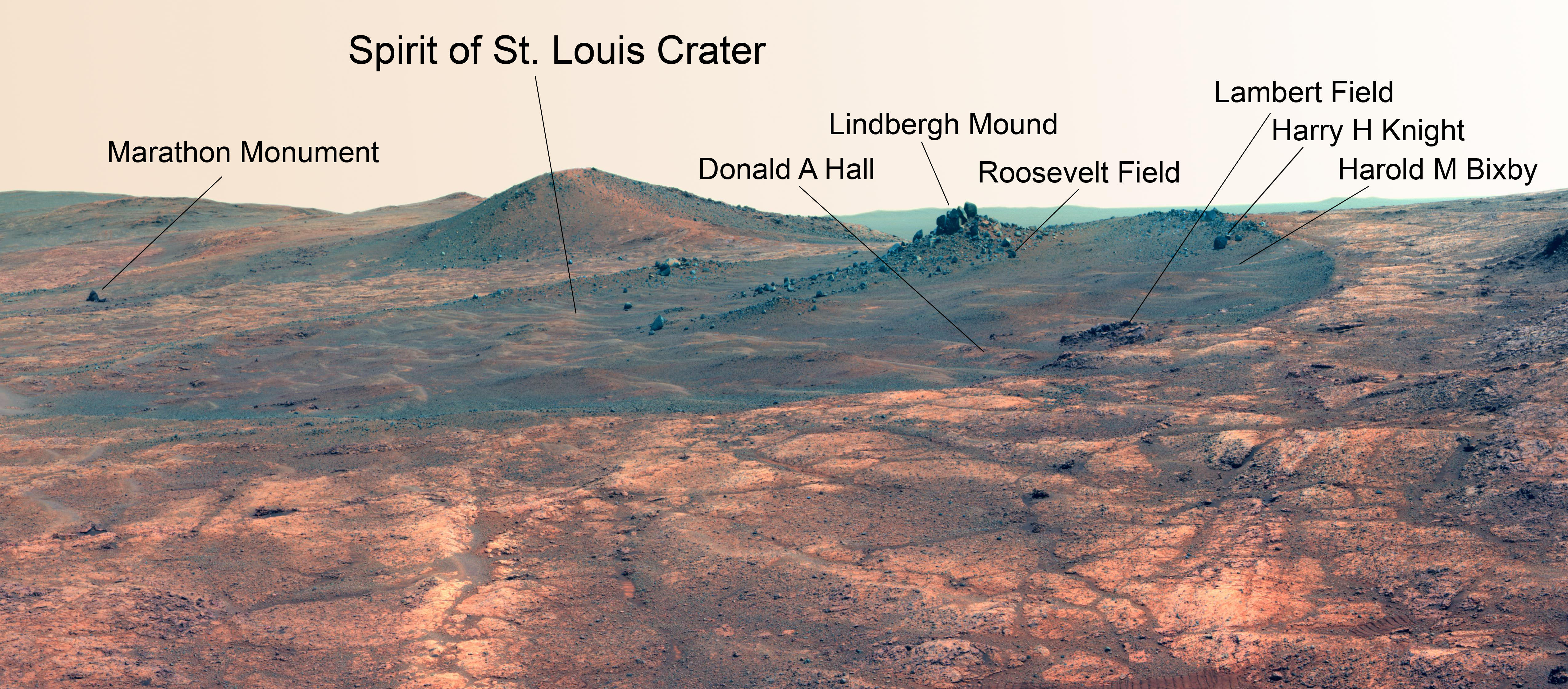
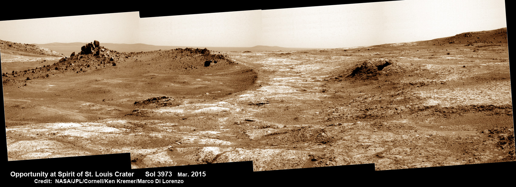
Martian Reminder of a Pioneering Flight. Names related to the first solo nonstop flight across the Atlantic have been informally assigned to a crater NASA's Opportunity Mars rover is studying. This false-color view of the "Spirit of St. Louis Crater" and the "Lindbergh Mound" inside it comes from Opportunity's panoramic camera. Image Credit: NASA/JPL-Caltech/Cornell Univ./Arizona State Univ.
Martian Reminder of a Pioneering Flight. Names related to the first solo nonstop flight across the Atlantic have been informally assigned to a crater NASA’s Opportunity Mars rover is studying. This false-color view of the “Spirit of St. Louis Crater” and the “Lindbergh Mound” inside it comes from Opportunity’s panoramic camera. Image Credit: NASA/JPL-Caltech/Cornell Univ./Arizona State Univ. See additional Opportunity photo mosaics below [/caption]
The science team leading NASA’s long-lived Opportunity rover mission is honoring the pioneering solo nonstop trans-Atlantic flight of aviator Charles Lindbergh by assigning key features of the Mars mountain top crater area the rover is now exploring with names related to the historic flight.
Opportunity is now studying an elongated crater called “Spirit of St. Louis” and an unparalleled rock spire within the crater called “Lindbergh Mound” which are named in honor of Lindbergh himself and his plane – the Spirit of Saint Louis.
“Spirit of Saint Louis” crater is quite special in many ways related not just to history but also to science and exploration – that very reasons behind Lindbergh’s flight and Opportunity’s astounding mission to the Red Planet.
The team is ecstatic that the 11 year old rover Opportunity has reached “Spirit of St. Louis Crater” because its serves as the gateway to the alien terrain of “Marathon Valley” holding caches of water altered minerals that formed under environmental conditions conducive to support Martian microbial life forms, if they ever existed.
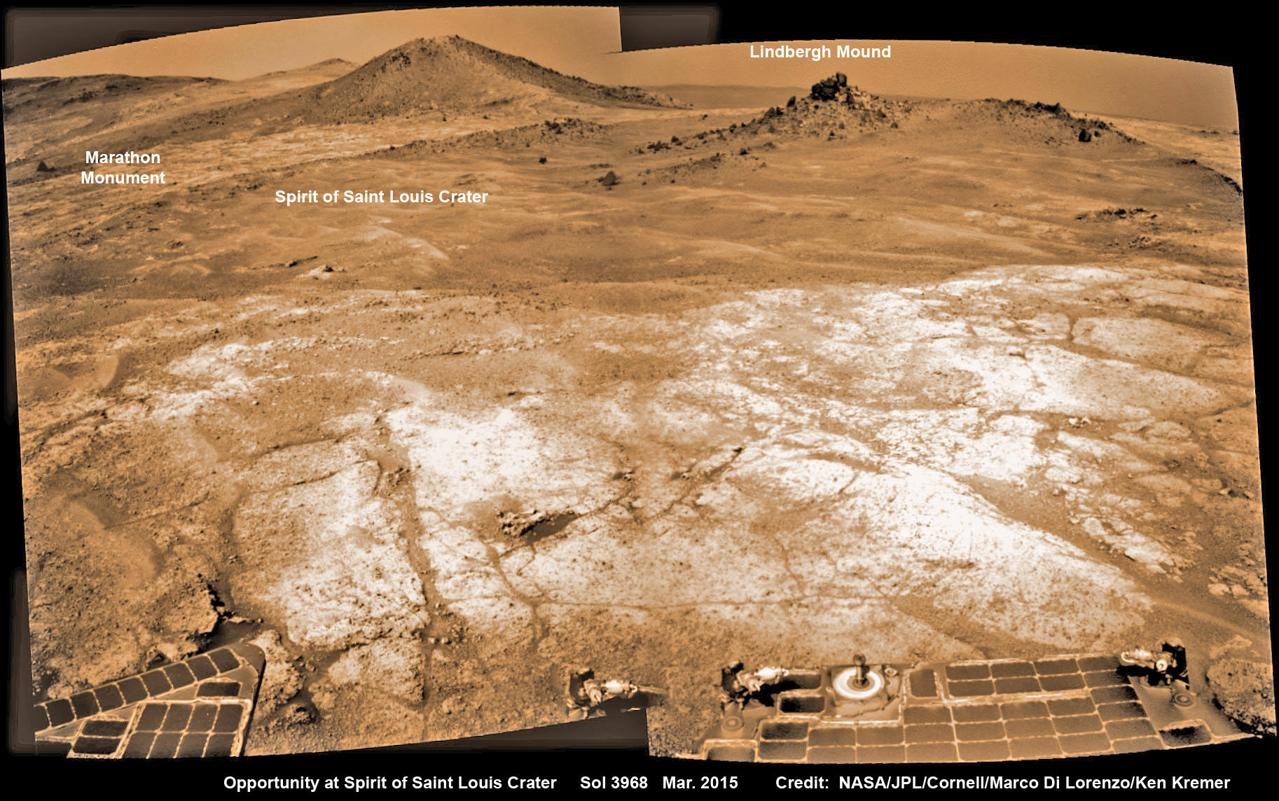
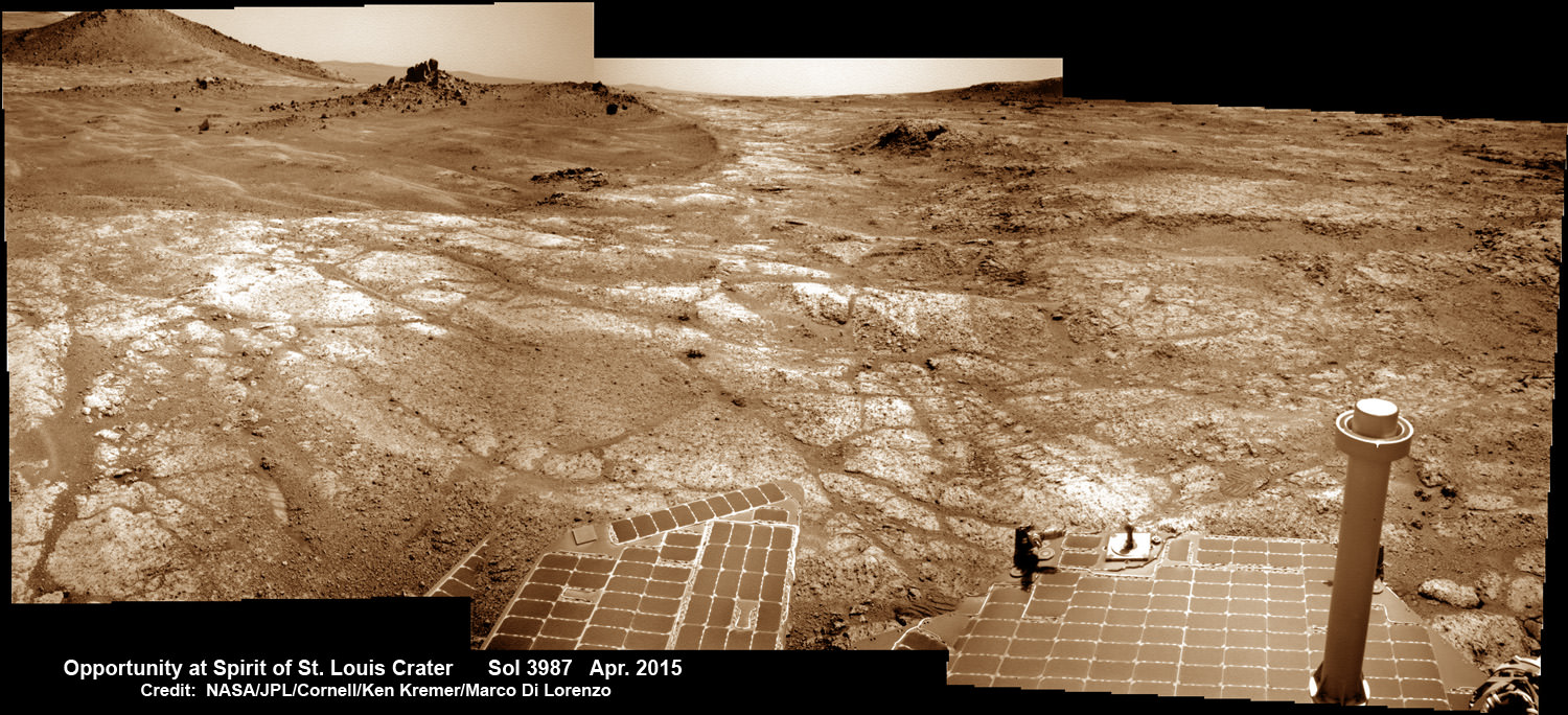
The crater, rock spire and several features in and near it are shown in several recent panoramic mosaics, above and below, created by the rover team and separately by the image processing team of Ken Kremer and Marco Di Lorenzo.
Opportunity’s view (annotated) on the day the NASA rover exceeded the distance of a marathon on the surface of Mars on March 24, 2015, Sol 3968 with features named in honor of Charles Lindbergh’s historic solo flight across the Atlantic Ocean in 1927. Rover stands at Spirit of Saint Louis Crater near mountaintop at Marathon Valley overlook and Martian cliffs at Endeavour crater holding deposits of water altered clay minerals. This navcam camera photo mosaic was assembled from images taken on Sol 3968 (March 24, 2015) and colorized. Credit: NASA/JPL/Cornell/Marco Di Lorenzo/Ken Kremer/kenkremer.com
Marathon Valley and Spirit of St. Louis Crater are located just a few hundred meters south of a Mars mountain summit at a majestic spot called Cape Tribulation. It lies along a marvelous ridgeline along the western rim of Endeavour crater, which spans some 22 kilometers (14 miles) in diameter.
“What’s the connection between St. Louis and the Spirit of St. Louis? Lindbergh flew from New York to Paris, but he named his aircraft for the St. Louis citizens who purchased it for him,” says Prof. Ray Arvidson, the rover Deputy Principal Investigator of Washington University in St. Louis.
The raw images for the mosaics were taken in March and April 2015 using the robots mast mounted pancam and navcam cameras. The mosaics are shown in false color and colorized versions, annotated and unannotated.
Charles Lindbergh embarked in May 1927 on his history making flight from New York to Paris in the airplane he named Spirit of St. Louis, the first solo nonstop flight across the Atlantic.
Opportunity at Spirit of Saint Louis crater scanning into Marathon Valley and Endeavour crater from current location on Mars in April 2015 in this photo mosaic. The crater, featuring an odd mound of rocks now named Lingbergh Mound, is the gateway to Marathon Valley and exposures of water altered clay minerals. This navcam camera photo mosaic was assembled from images taken on Sol 3987 (April 12, 2015) and colorized. Credit: NASA/JPL/Cornell/ Ken Kremer/kenkremer.com/Marco Di Lorenzo
The shallow Spirit of St. Louis Crater is about 110 feet (34 meters) long and about 80 feet (24 meters) wide, with a floor slightly darker than surrounding terrain, says NASA.
Lindbergh Mound dominates the crater measuring about 7 to 10 feet (2 to 3 meters) tall, rising higher than the crater’s rim.
The annotations also include features named to recognize the financial backing for the flight from St. Louis residents including Harold M. Bixby and Harry M. Knight. The plane’s designer was Donald A. Hall.
Opportunity arrives at Spirit of Saint Louis crater and peers into Marathon Valley and Endeavour crater from current location on Mars as of April 3, 2015 in this photo mosaic. The crater, featuring an odd mound of rocks now named Lingbergh Mound, is the gateway to Marathon Valley and exposures of water altered clay minerals. This pancam camera photo mosaic was assembled from images taken on Sol 3973 (March 29, 2015) and colorized. Credit: NASA/JPL/Cornell/ Ken Kremer/kenkremer.com/Marco Di Lorenzo
Among other features named are Roosevelt Field, the spot on New York’s Long Island from which Lindbergh took off, and Marathon Monument, where the rover completed a her first marathon distance runners drive on Mars. The team picked a distinctive outcrop, Marathon Monument, to mark the finish line, said NASA officials.
“The science team for the rover picks crater names from a list of “vessels of exploration,” including ships of sail and spacecraft as well as aircraft. As long as the rover remains in the crater, names for interesting features will drawn from a list of names related to this famous flight,” according to a NASA statement.
Stay tuned here for Ken’s continuing Earth and planetary science and human spaceflight news.
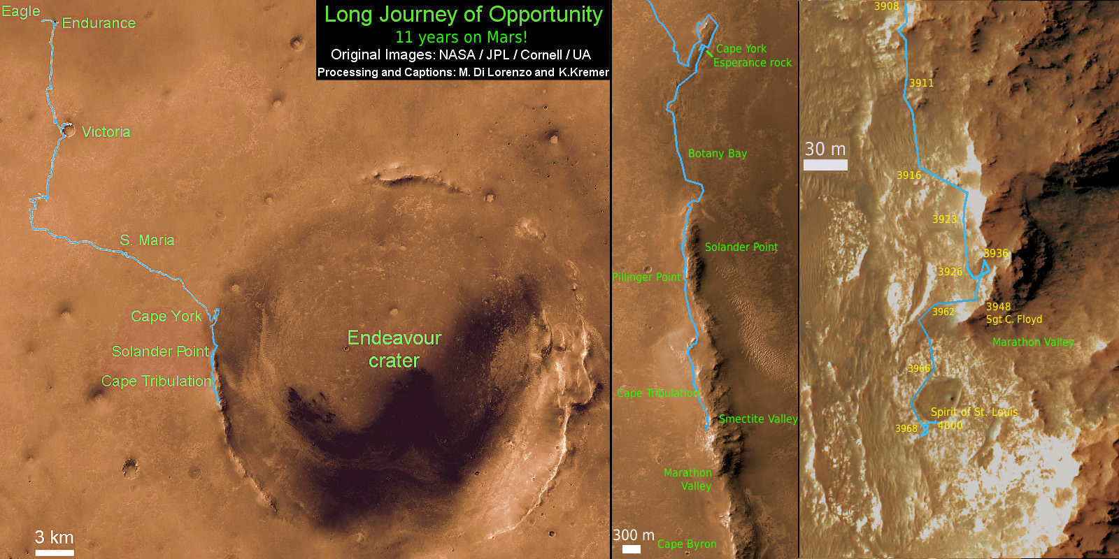
11 Year Traverse Map for NASA’s Opportunity rover from 2004 to 2015. This map shows the entire path the rover has driven during 11 years and three months and a marathon runners distance on Mars for over 4000 Sols, or Martian days, since landing inside Eagle Crater on Jan 24, 2004 -to current location just past the Cape Tribulation summit at the western rim of Endeavour Crater at Marathon Valley. Rover surpassed Marathon distance on Sol 3968 and marked 11th Martian anniversary on Sol 3911. Opportunity discovered clay minerals at Esperance – indicative of a habitable zone – and is searching for more on the road ahead at Marathon Valley. Credit: NASA/JPL/Cornell/ASU/Marco Di Lorenzo/Ken Kremer – kenkremer.com
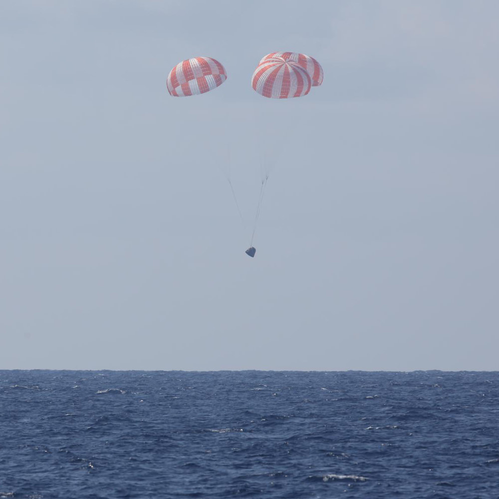
Release of SpaceX-6 Dragon on May 21, 2015 from the International Space Station for Pacific Ocean splashdown later in the day. Credit: NASA/Terry Virts
Release of SpaceX-6 Dragon on May 21, 2015 from the International Space Station for Pacific Ocean splashdown later in the day. Credit: NASA/Terry Virts Story updated with further details and photos[/caption]
SpaceX Dragons seem to be flying nearly everywhere these days, coming and going at a record pace to the delight and relief of NASA, researchers and the space faring crews serving aboard the International Space Station (ISS). As one Dragon returned to Earth from space today, May 21, another Dragon prepares to soar soon to space.
The commercial SpaceX-6 cargo Dragon successfully splashed down in the Pacific Ocean at 12:42 p.m. EDT (1642 GMT) today, Thursday, about 155 miles southwest of Long Beach, California, some five hours after it was released from the grip of the stations robotic arm this morning at 7:04 a.m. EDT by the Expedition 43 crew as the craft were flying some 250 miles (400 km) above Australia.
The ocean splashdown marked the conclusion to the company’s sixth cargo resupply mission to the ISS under a commercial contract with NASA. Overall this was the seventh trip by a Dragon spacecraft to the station since the inaugural flight in 2012.
Following the launch failure and uncontrolled destructive plummet back to Earth of the Russian Progress 59 cargo freighter earlier this month, the station and its six person international crews are more dependent than ever on the SpaceX commercial supply train to orbit to keep it running and humming with productive science.
Working from a robotics work station in the domed cupola, NASA astronaut Scott Kelly released the Dragon CRS-6 spacecraft from the grappling snares of the 57.7-foot-long (17-meter-long) Canadian-built robotic arm with help from fellow NASA astronaut Terry Virts. Kelly is a member of the first 1 Year ISS mission crew, along with Russian cosmonaut Mikhail Kornienko.
The capsule then performed an intricate series of three departure burns and maneuvers to move beyond the imaginary 656-foot (200-meter) “keep out sphere” around the station and begin its five and a half hour long trip back to Earth.
The station crew had packed Dragon with almost 3,100 pounds of NASA cargo from the International Space Station. The including research samples pertaining to a host of experiments on how spaceflight and microgravity affect the aging process and bone health as well as no longer need items and trash to reduce station clutter.
The SpaceX Dragon cargo spacecraft was released from the International Space Station’s robotic arm at 7:04 a.m. EDT Thursday. The capsule then performed a series of departure burns and maneuvers to move beyond the 656-foot (200-meter) “keep out sphere” around the station and begin its return trip to Earth. Credits: NASA TV
“Spaceflight-induced health changes, such as decreases in muscle and bone mass, are a major challenge facing our astronauts,” said Julie Robinson, NASA’s chief scientist for the International Space Station Program Office at NASA’s Johnson Space Center in Houston, in a statement.
“We investigate solutions on the station not only to keep astronauts healthy as the agency considers longer space exploration missions but also to help those on Earth who have limited activity as a result of aging or illness.”
The Dragon was retrieved from the ocean by recovery boats following the parachute assisted splashdown. It will be transported to Long Beach, California for removal and return of the NASA cargo. The capsule itself will be shipped to SpaceX’s test facility in McGregor, Texas, for processing to remove cargo and inspection of its performance.
Dragon splashes down into the Pacific Ocean, carrying 3,100 lbs of cargo and science for NASA on May 21, 2015, Credit: SpaceX.
“The returning Space Aging study, for example, examines the effects of spaceflight on the aging of roundworms, widely used as a model for larger organisms,” noted NASA in a statement.
“By growing millimeter-long roundworms on the space station, researchers can observe physiological changes that may affect the rate at which organisms age. This can be applied to changes observed in astronauts, as well, particularly in developing countermeasures before long-duration missions.”
Dragon departed after having spent a record setting stay of 33 days berthed to the station at an Earth facing port on the Harmony node.
Dragon is also the only current US means for sending cargo to the station after the loss of the Orbital Sciences Cygnus craft in the Antares rocket explosion last October.
The SpaceX CRS-6 Dragon successfully blasted off atop a Falcon 9 booster from Space Launch Complex 40 at Cape Canaveral Air Force Station in Florida on April 14, 2015 at 4:10 p.m. EDT (2010:41 GMT) on the CRS-6 (Commercial Resupply Services-6) mission.
SpaceX Falcon 9 and Dragon blastoff from Space Launch Complex 40 at Cape Canaveral Air Force Station in Florida on April 14, 2015 at 4:10 p.m. EDT on the CRS-6 mission to the International Space Station. Credit: Ken Kremer/kenkremer.com
The resupply vessel had arrived three days later on April 17 and was successfully snared by the Expedition 43 Flight Engineer Samantha Cristoforetti of the European Space Agency, the first female Italian astronaut.
Dragon launched on April 14 with more than 4,300 pounds of supplies, science experiments, and technology demonstrations, including critical materials to support about 40 of more than 250 science and research investigations during the station’s Expeditions 43 and 44.
An Espresso machine was also aboard and delivered to enhance station morale during the daily grind some 250 miles above Earth.
Among the research investigations were a fresh batch of 20 rodents for the Rodent Research Habitat, and experiments on osteoporosis to counteract bone deterioration in microgravity, astronaut vision loss, protein crystal growth, and synthetic muscle for prosthetics and robotics.
CRS-6 marks the company’s sixth operational resupply mission to the ISS under a $1.6 Billion contract with NASA to deliver 20,000 kg (44,000 pounds) of cargo to the station during a dozen Dragon cargo spacecraft flights through 2016 under NASA’s original Commercial Resupply Services (CRS) contract.
Following the complete success of the SpaceX Dragon CRS-6 mission, NASA just announced that the next SpaceX Dragon is currently slated to launch on June 26 at 11:09 a.m. EDT.
The Dragon will carry critical US equipment enabling docking by the SpaceX Crew Dragon and Boeing CST-100 astronaut transporters.
Read Ken’s earlier onsite coverage of the CRS-6 launch from the Kennedy Space Center and Cape Canaveral Air Force Station.
Stay tuned here for Ken’s continuing Earth and planetary science and human spaceflight news.
SpaceX Falcon 9 and Dragon blastoff from Space Launch Complex 40 at Cape Canaveral Air Force Station in Florida on April 14, 2015 at 4:10 p.m. EDT on the CRS-6 mission to the International Space Station. Credit: Ken Kremer/kenkremer.com
Video caption: SpaceX CRS-6 Falcon 9 Launch to the International Space Station on April 14, 2015. Credit: Alex Polimeni