Deadly Monster Winter Storm Batters US Eastern Seaboard – More Snow and Ice on the Way!

This visible image of the winter storm over the U.S. south and East Coast was taken by NOAA's GOES-13 satellite on Feb. 13 at 1455 UTC/9:45 a.m. EST. Snow covered ground can be seen over the Great Lakes region and Ohio Valley. Image Credit: NASA/NOAA GOES Project

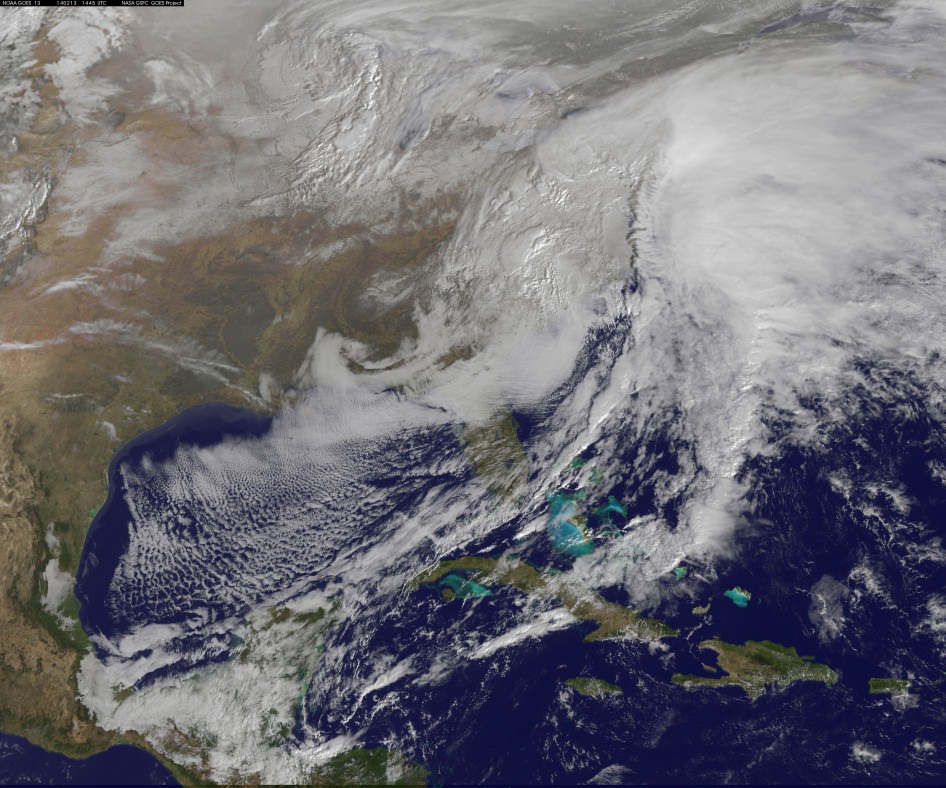
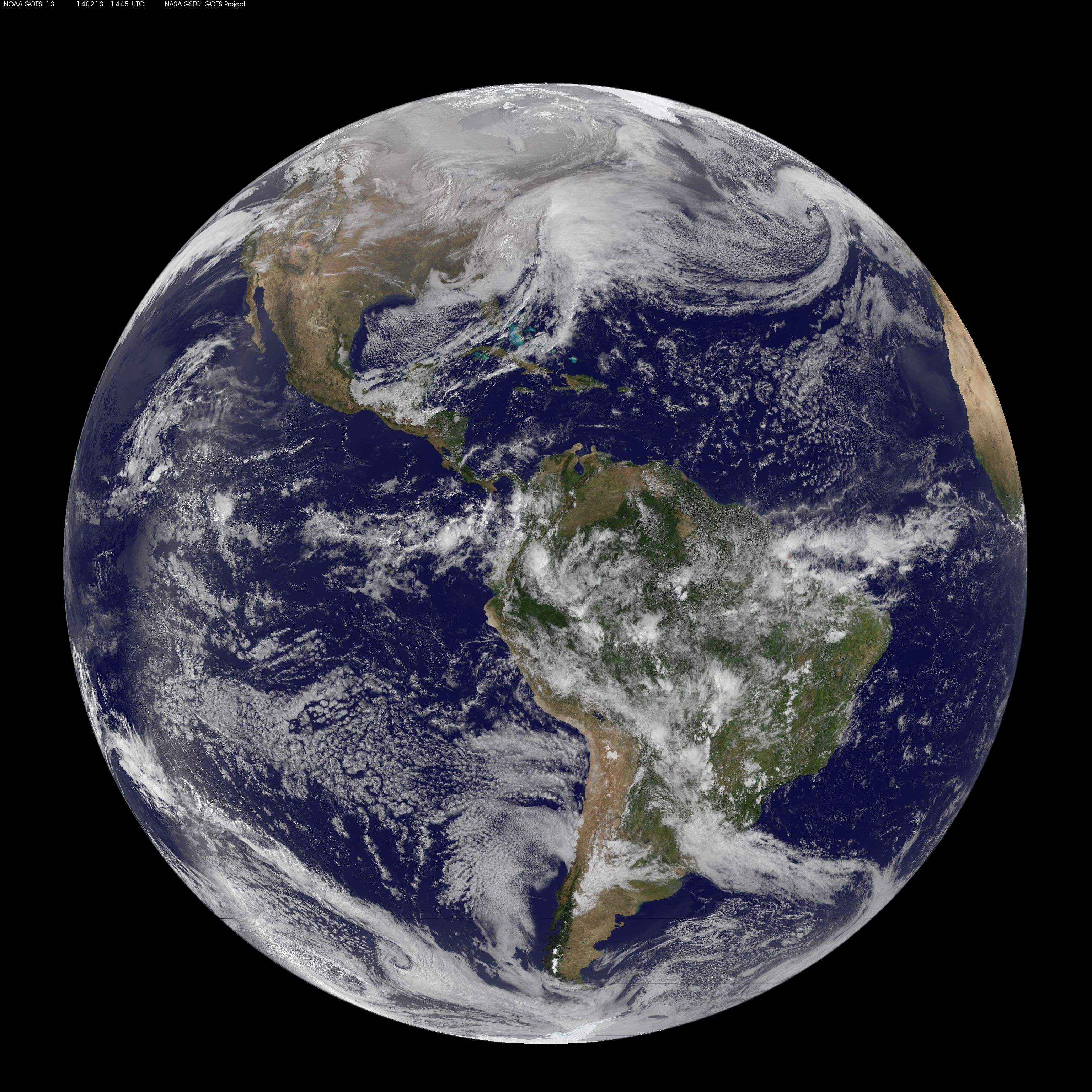
This visible image of the winter storm over the U.S. south and East Coast was taken by NOAA’s GOES-13 satellite on Feb. 13 at 1455 UTC/9:45 a.m. EST. Snow covered ground can be seen over the Great Lakes region and Ohio Valley. Image Credit: NASA/NOAA GOES Project
Story updated[/caption]

A deadly monster storm is battering virtually the entire US Eastern seaboard today, Thursday, Feb. 13, as it moves from the Southeast to the Northeast and into the New England states, wreaking havoc and causing miserable weather conditions for over 100 million Americas.

This afternoon, NASA and NOAA published a new image taken by a GOES satellite that showed the extent of the clouds associated with the massive winter storm over the US East Coast – see above and below.

Blizzard, white out and slippery conditions have already caused more than 18 deaths.

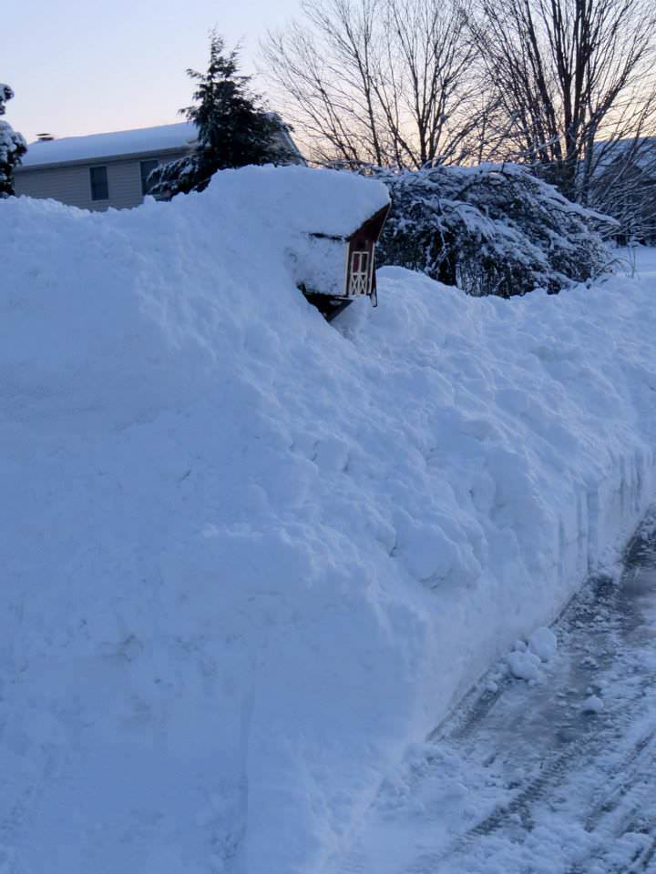
The killer storm has brought relentless waves of snow, sleet and ice over the past two days covering a vast swath stretching from inland to coastal areas as it moved up from the southern to northern states.

More than a foot of snow has already fallen in many areas today stretching from the Mid-Atlantic into the entire Northeast region.

Several states have declared states of emergency.

This is the season’s 12th snow storm. In many Northeast localities, the accumulated snowfall totals are three times the normal average. As a result many municipalities are running out of road salt.

And to add insult to injury, much more icy snow is falling overnight into Friday on top of the massive existing mounds and piles of frozen ice and snow that’s accumulated over the past few weeks of subfreezing temperatures.

There are also predictions for patches of “thunder snow” — which is a snow storm mixed with thunder and lightning!

Full disk image of the winter storm over the U.S. south and East Coast was taken by NOAA's GOES-13 satellite on Feb. 13 at 1455 UTC/9:45 a.m. EST. Credit:  NASA/NOAA GOES Project
Full disk image of the winter storm over the U.S. south and East Coast was taken by NOAA’s GOES-13 satellite on Feb. 13 at 1455 UTC/9:45 a.m. EST. Credit: NASA/NOAA GOES Project

Incredibly, another round of snow is forecast for Saturday.

Much of the I-95 corridor where I also live has been especially hard hit.

The image above was created from data captured by NOAA’s GOES-East satellite today, Feb. 13 at 1455 UTC/9:45 a.m. EST by a team from the NASA/NOAA’s GOES Project at NASA’s Goddard Space Flight Center in Greenbelt, Md.

“The clouds and fallen snow data from NOAA’s GOES-East satellite were overlaid on a true-color image of land and ocean created by data from the Moderate Resolution Imaging Spectroradiometer or MODIS instrument that flies aboard NASA’s Aqua and Terra satellites,” said NASA in a statement.

An eight months pregnant 36 year old women was tragically killed in New York City accident today by a snowplow. Thank God the unborn baby was saved and delivered by cesarean section.

The storm has caused thousands of traffic accidents and several deaths.

Video Caption: This animation of NOAA’s GOES satellite data shows the progression of the major winter storm in the U.S. south from Feb. 10 at 1815 UTC/1:15 p.m. EST to Feb. 12 to 1845 UTC/1:45 p.m. EST. Credit: NASA/NOAA GOES Project, Dennis Chesters

Hundreds of thousands of customers have lost power due to fallen tree limbs on exposed power lines, mostly in the southeast. In recent days, hundreds of thousands of us here in the Northeast lost power after a severe ice storm.

Mountains of snow inundate the Northeast. Credit: Mark Usciak

Most of those affected were left with no heat in subfreezing temperatures. It’s definitely no fun when you can see you exhaled breath – indoors.

Many school districts were closed today. But not in NYC where the new Mayor Bill DeBlasio kept schools open, and faced a hail of criticism – including from NBC News weatherman Al Roker.

Over 6500 airplane flights have been cancelled, stranding over a half million people.

So after days of shoveling, even more is on tap for the morning. Be careful, pace yourself and don’t overdo it – as several people died from heart attacks digging out the heavy slushy mess


Here is this evenings forecast (Feb 13) from the National Weather Service (NWS):

STORM SUMMARY NUMBER 09 FOR SOUTHERN PLAINS TO EAST COAST WINTER STORM
NWS WEATHER PREDICTION CENTER COLLEGE PARK MD – – 1000 PM EST THU FEB 13 2014

…LOW PRESSURE CENTER HAS MOVED OFF THE NEW JERSEY COAST AND IS
RAPIDLY INTENSIFYING…HEAVY SNOW BANDS IMPACTING INTERIOR
NORTHEAST AND I 95 CORRIDOR…WINDS INCREASING ACROSS THE AFFECTED
REGION…

WINTER STORM WARNINGS AND WINTER WEATHER ADVISORIES ARE IN EFFECT
FOR THE NORTHERN MID ATLANTIC AND NORTHEAST….

FOR A DETAILED GRAPHICAL DEPICTION OF THE LATEST
WATCHES…WARNINGS AND ADVISORIES…PLEASE SEE WWW.WEATHER.GOV

AT 900 PM EST…THE MAIN CENTER OF A RAPIDLY INTENSIFYING LOW
PRESSURE SYSTEM WITH ESTIMATED CENTRAL PRESSURE OF 986 MB…29.12
INCHES…WAS LOCATED JUST EAST OF THE SOUTHERN NEW JERSEY COAST.
NATIONAL WEATHER SERVICE DOPPLER RADAR AND SURFACE OBSERVATIONS
INDICATED THAT OVER THE PAST FEW HOURS…A BAND OF HEAVY SNOW WAS
IMPACTING CENTRAL PENNSYLVANIA ACROSS NORTHERN NEW ENGLAND TO
NORTHERN MAINE. MEANWHILE…ANOTHER BAND OF MODERATE TO HEAVY
SNOW WAS LOCATED ALONG THE I 95 CORRIDOR FROM WASHINGTON DC TO NEW YORK CITY. EAST OF I 95 THE PRECIPITATION TYPE IS MAINLY RAIN…BUT A CHANGEOVER BACK TO SNOW IS EXPECTED.

Stay tuned here for Ken’s continuing planetary and human spaceflight news.

Ken Kremer

Recent ice and snow storms caused hundreds of thousands to lose power and heat in the Northeast. Credit: Ken Kremer
Recent ice and snow storms caused hundreds of thousands to lose power and heat in the Northeast in subfreezing temperatures. Credit: Ken Kremer
Mountains of snow inundate the Northeast. Credit: Mark Usciak

China’s Yutu Moon Rover Alive and Awake for 3rd Lunar Day of Exploration despite Malfunction

This composite view shows China’s Yutu rover heading south and away forever from the Chang’e-3 landing site about a week after the Dec. 14, 2013 touchdown at Mare Imbrium. This cropped view was taken from the 360-degree panorama. See complete 360 degree landing site panorama herein. Chang’e-3 landers extreme ultraviolet (EUV) camera is at right, antenna at left. Credit: CNSA/Chinanews/Ken Kremer/Marco Di Lorenzo – kenkremer.com. See our complete Yutu timelapse pano at NASA APOD Feb. 3, 2014: http://apod.nasa.gov/apod/ap140203.htm

Yutu Lives!

The little ‘rabbit’ beloved worldwide has now phoned home and actually survived the perils of the long lunar night and is alive and awake to start a 3rd day of scientific exploration despite suffering a serious malfunction as it entered the latest hibernation period two weeks ago.

“Yutu has come back to life!” said Pei Zhaoyu, the spokesperson for China’s lunar probe program, according to a breaking news report by the state owned Xinhua news agency.

“Experts are still working to verify the causes of its mechanical control abnormality.”

The Chang’e-3 mothership lander and piggybacked Yutu surface rover soft landed on the Moon on Dec. 14, 2013 at Mare Imbrium (Sea of Rains) – marking China’s first successful spacecraft landings on an extraterrestrial body in history.

Yutu’s new lease on life also comes after Monday’s (Feb. 11) premature report of the robots demise by the state owned China News Service, reported here.

However, “Yutu failed to power-up Monday [Feb 11] and data about its current condition and repair progress is still being collected and analyzed,” Xinhua and CCTV (China state run television) reported.

This indicates that Yutu was in fact feared lost for some time by the mission team, until further efforts finally resulted in the detection of a signal from the spacecraft – and a welcome reversal of yesterdays news!

The robot “has now been restored to its normal signal reception function,” says Pei.

Side by side screenshot photos of the Chang'e-3 moon lander (L) and the Yutu moon rover during the mutual-photograph process, at the Beijing Aerospace Control Center in Beijing, on Dec. 15, 2013. The moon rover and the moon lander took photos of each other  marking the complete success of the Chang'e-3 lunar probe mission. (Xinhua/Ding Lin)
Side by side screenshot photos of the Chang’e-3 moon lander (L) and the Yutu moon rover during the mutual-photograph process, at the Beijing Aerospace Control Center in Beijing, on Dec. 15, 2013. The moon rover and the moon lander took photos of each other marking the complete success of the Chang’e-3 lunar probe mission. (Xinhua/Ding Lin)

Earlier today (Feb. 12) amateur radio operators at UHF-satcom reported detection of a signal from Yutu.

But much technical work remains ahead for the engineering and science teams to ascertain why it malfunctioned and whether the six wheeled rover can be restored to partial or full functionality.

As night fell on Jan. 25, the rover entered its second two week long period of dormancy just as the rover “experienced a mechanical control abnormality,” according to a report by China’s official government newspaper, The People’s Daily.

“Yutu went into sleep under an abnormal status,” Pei said.

“Experts were initially concerned that it might not be able to survive the extremely low temperatures during the lunar night.”

360-degree time-lapse color panorama from China’s Chang’e-3 lander This 360-degree time-lapse color panorama from China’s Chang’e-3 lander shows the Yutu rover at three different positions during its trek over the Moon’s surface at its landing site from Dec. 15-22, 2013 during the 1st Lunar Day. Credit: CNSA/Chinanews/Ken Kremer/Marco Di Lorenzo – kenkremer.com.  See our Yutu timelapse pano at NASA APOD Feb. 3, 2014: http://apod.nasa.gov/apod/ap140203.htm
360-degree time-lapse color panorama from China’s Chang’e-3 lander
This 360-degree time-lapse color panorama from China’s Chang’e-3 lander shows the Yutu rover at three different positions during its trek over the Moon’s surface at its landing site from Dec. 15-22, 2013 during the 1st Lunar Day. Credit: CNSA/Chinanews/Ken Kremer/Marco Di Lorenzo – kenkremer.com. See our Yutu timelapse pano at NASA APOD Feb. 3, 2014: http://apod.nasa.gov/apod/ap140203.htm

Each lunar day and night lasts for alternating periods of 14 Earth days.

During each long night, the Moon’s temperatures plunge dramatically to below minus 180 Celsius, or minus 292 degrees Fahrenheit.

Both solar powered probes must enter hibernation mode during each lunar night to conserve energy and protect their science instruments and control mechanisms, computers and electronics.

“The rover stands a chance of being saved now that it is still alive,” Pei stated.

Yutu, which translates as ‘Jade Rabbit’ is named after the rabbit in Chinese mythology that lives on the Moon as a pet of the Moon goddess Chang’e.

‘Jade Rabbit’ had departed the landing site forever, and was journeying southwards as the anomoly occurred – about six weeks into its planned 3 month long moon roving expedition to investigate the moon’s surface composition and natural resources.

The 140 kg Yutu robot is located some 100 m south of the lander.

Traverse Path of Yutu rover from Dec. 14 landing to Dec. 21. Landscape textured with Chang'e 3 imagery from space and ground.  Credit: CNSA/BACC
Traverse Path of Yutu rover from Dec. 14 landing to Dec. 21. Landscape textured with Chang’e 3 imagery from space and ground. Credit: CNSA/BACC

Definitive word about the Chang’e-3 lander has not yet been announced. But it is expected to survive since no malfunctions have been reported. It has a 1 year design lifetime.

Xinhua stated that Chinese space officials will comment on the landers status soon.

The 1200 kg stationary lander is expected to return science data about the Moon and conduct telescopic observations of the Earth and celestial objects for at least one year.

Chang’e-3 and Yutu landed on a thick deposit of volcanic material.

The inaugural pair of probes could be the forerunners to a manned Chinese Moon landing mission a decade from now.

China’s current plans call for the Chang’e-4 Moon lander/rover to launch in 2016, perhaps with some upgrades and lessons learned from the ongoing mission.

China is only the 3rd country in the world to successfully soft land a spacecraft on Earth’s nearest neighbor after the United States and the Soviet Union.

Stay tuned here for Ken’s continuing Chang’e-3, Orion, Orbital Sciences, SpaceX, commercial space, LADEE, Mars and more planetary and human spaceflight news.

Ken Kremer

Time for Earth to bid China’s Yutu Moon Rover Farewell ?

Farewell Yutu - artistic impression of Earthrise over Yutu at lunar landing site. This composite photomosaic combines farewell view of China’s Yutu rover with Moon’s surface terrain at Mare Imbrium landing site and enlarged photo of Earth, all taken by Chang’e-3 lander. Not a science image. Credit: CNSA/Chinanews/Ken Kremer/Marco Di Lorenzo – kenkremer.com

Farewell Yutu – artistic impression of Earthrise over Yutu at lunar landing site. This composite timelapse photomosaic combines farewell view of China’s Yutu rover with Moon’s surface terrain at Mare Imbrium landing site and enlarged photo of Earth – all actual images taken by Chang’e-3 lander. Not a science image. Credit: CNSA/Chinanews/Ken Kremer/Marco Di Lorenzo – kenkremer.com
See complete Yutu timelapse panorama below and at NASA APOD Feb. 3, 2014:http://apod.nasa.gov/apod/ap140203.html
Story and Headline revised and updated[/caption]

Update: There might yet be hope for Yutu. Amateur radio operators at UHF-satcom reported detection of a signal from Yutu today. But no update has been reported on the China News Service website or other official state media. Yutu’s fate is unknown.]

Update 2: Yutu is alive. story and headline revised. Further details – here
………..

For a time, it seemed China’s maiden moon rover ‘Yutu’, beloved by millions worldwide, had been lost.

The apparently unfortunate and sad breaking news was just reported today in an ultra brief dispatch by the English language version of Chinadaily – with the headline “Loss of lunar rover.”

But the death notice by Chinese officials turned out to be premature when a signal was detected a day later.

It had been thought that Yutu froze to death due to a pre-hibernation mechanical malfunction and failed to wake up and communicate with China’s mission controllers in Beijing on Monday, Feb. 10, when daylight returned to the rovers Moon landing site at Mare Imbrium (Sea of Rains) at the start of what would have been Lunar Day 3 for the mission.

“China’s first lunar rover, Yutu, could not be restored to full function on Monday [Feb. 10] as expected,” wrote the state owned Chinadaily.com, China News Service agency.

The cause of the pre-hibernation malfunction may perhaps be traced back to a buildup of abrasive lunar dust, but no one knows at this time.

Note: This story has been updated as further details emerged.

Portrait photo of Yutu moon rover taken by camera on the Chang'e-3 moon lander on Dec. 15, 2013 shortly after rolling all 6 wheels onto lunar surface.  Credit: Chinese Academy of Sciences
Portrait photo of Yutu moon rover taken by camera on the Chang’e-3 moon lander on Dec. 15, 2013 shortly after rolling all 6 wheels onto lunar surface. Credit: Chinese Academy of Sciences

Yutu has touched the hearts of countless Earthlings since the history making landing on the desolate gray plains of the the Moon atop the Chang’e-3 lander two month ago on Dec. 14, 2013.

See our timelapse mosaic, artistic impression of Earthrise over Yutu – above – by the image processing team of Ken Kremer and Marco Di Lorenzo.

It combines real images of the Moon’s surface terrain with an intentionally enlarged photo of Earth – all snapped by the Chang’e-3 lander – as a homage to the mission.

See the complete timelapse mosaic herein and featured at NASA APOD on Feb 3, 2013.

Although definitive word about the Chang’e-3 lander has not yet been announced, it is expected to survive and has a 1 year design lifetime.

Potentially bad news about Yutu’s fate was not unexpected however, after Chinese space officials disclosed that the rover “experienced a mechanical control abnormality” two weeks ago, just as her 2nd lunar night was to begin, according to a report by China’s official government newspaper, The People’s Daily.

“Yutu experienced mechanical problems on Jan 25 and has been unable to function since then,” according to Chinadaily.com, China News service.

360-degree time-lapse color panorama from China’s Chang’e-3 lander This 360-degree time-lapse color panorama from China’s Chang’e-3 lander shows the Yutu rover at three different positions during its trek over the Moon’s surface at its landing site from Dec. 15-22, 2013 during the 1st Lunar Day. Credit: CNSA/Chinanews/Ken Kremer/Marco Di Lorenzo – kenkremer.com
360-degree time-lapse color panorama from China’s Chang’e-3 lander
This 360-degree time-lapse color panorama from China’s Chang’e-3 lander shows the Yutu rover at three different positions during its trek over the Moon’s surface at its landing site from Dec. 15-22, 2013 during the 1st Lunar Day.
Credit: CNSA/Chinanews/Ken Kremer/Marco Di Lorenzo – kenkremer.com
See our Yutu timelapse pano also at NASA APOD Feb. 3, 2014:
http://apod.nasa.gov/apod/ap140203.html

Each lunar day and night lasts for alternating periods of 14 Earth days.

The six wheeled Yutu rover and Chang’e-3 mothership lander had just finished sleeping through the terribly frigid two week long lunar night since they entered their second hibernation period on Jan. 24th and 25th respectively, and Chinese space engineers had hoped to reawaken both probes in the past few days.

No communications are possible during the period of nighttime dormancy.

This time-lapse color panorama from China’s Chang’e-3 lander shows the Yutu rover at two different positions during its trek over the Moon’s surface at its landing site from Dec. 15-18, 2013. This view was taken from the 360-degree panorama. Credit: CNSA/Chinanews/Ken Kremer/Marco Di Lorenzo.   See our complete Yutu timelapse pano at NASA APOD Feb. 3, 2014:  http://apod.nasa.gov/apod/ap140203.htm
This time-lapse color panorama from China’s Chang’e-3 lander shows the Yutu rover at two different positions during its trek over the Moon’s surface at its landing site from Dec. 15-18, 2013. This view was taken from the 360-degree panorama, herein. Credit: CNSA/Chinanews/Ken Kremer/Marco Di Lorenzo. See our complete Yutu timelapse pano also at NASA APOD Feb. 3, 2014: http://apod.nasa.gov/apod/ap140203.htm

Yutu, which translates as ‘Jade Rabbit’ is named after the rabbit in Chinese mythology that lives on the Moon as a pet of the Moon goddess Chang’e.

The piggybacked pair of Chinese probes safely touched down on the Moon at Mare Imbrium near the Bay of Rainbows on Dec. 14, 2013.

Photo of Chang'e-3 moon lander emblazoned with Chinese national flag taken by the panoramic camera on the Yutu moon rover on Dec. 22, 2013. Credit: CNSA
Photo of Chang’e-3 moon lander emblazoned with Chinese national flag taken by the panoramic camera on the Yutu moon rover on Dec. 22, 2013. Credit: CNSA

Apparently one of Yutu’s solar panels did not fold back properly over the instrument laden mast after it was lowered to a horizontal position into a warmed electronics box where it is shielded and insulated from the extremely frigid lunar night time temperatures.

Dust accumulation on the rover and gears may possibly be to blame for the failure to retract, based on unofficial accounts.

China has not released any official or detailed information on the cause of the malfunction or recovery actions taken by Chinese space engineers.

Such a malfunction could spell doom for the fragile electronic and computer components in the unprotected mast mounted instruments and systems, including the color and navigation cameras and the high gain antenna.

During each 14 Earth-day long night, the Moon’s temperatures plunge dramatically to below minus 180 Celsius, or minus 292 degrees Fahrenheit.

‘Jade Rabbit’ had departed the landing site forever, and was journeying southwards as the incident occurred – about six weeks into its planned 3 month long moon roving expedition to investigate the moon’s surface composition and natural resources.

The 140 kg Yutu robot drove off a pair of ramps and onto the moon seven hours after the Dec. 14, 2013 touchdown.

The 1200 kg stationary lander is expected to return science data about the Moon and telescopic observations of the Earth and celestial objects for at least one year.

Chang’e-3 and Yutu landed on a thick deposit of volcanic material.

Chang’e-3 lander and Yutu rover – from Above And Below  Composite view shows China’s Chang’e-3 lander and Yutu rover from Above And Below (orbit and surface) – lander color panorama (top) and orbital view from NASA’s LRO orbiter (bottom). Chang’e-3 lander color panorama shows Yutu rover after it drove down the ramp to the moon’s surface and began driving around the landers right side to the south. Yellow lines connect craters seen in the lander panorama and the LROC image from LRO (taken at a later date after the rover had moved), red lines indicate approximate field of view of the lander panorama. Credit: CNSA/NASA/Ken Kremer/Marco Di Lorenzo/Mark Robinson
Chang’e-3 lander and Yutu rover – from Above And Below
Composite view shows China’s Chang’e-3 lander and Yutu rover from Above And Below (orbit and surface) – lander color panorama (top) and orbital view from NASA’s LRO orbiter (bottom). Chang’e-3 lander color panorama shows Yutu rover after it drove down the ramp to the moon’s surface and began driving around the landers right side to the south. Yellow lines connect craters seen in the lander panorama and the LROC image from LRO (taken at a later date after the rover had moved), red lines indicate approximate field of view of the lander panorama. Credit: CNSA/NASA/Ken Kremer/Marco Di Lorenzo/Mark Robinson

They were designed to conduct their science investigations and work independently of one another.

China can be proud of its magnificent space flight accomplishment.

Chang’e-3 was the first spacecraft from Earth to soft land on the Moon in nearly four decades since the touchdown of the Soviet Union’s Luna 24 sample return spacecraft back in 1976.

America’s last visit to the Moon’s surface occurred with the manned Apollo 17 landing mission – crewed by astronauts Gene Cernan and Harrison ‘Jack’ Schmitt , who coincidentally ascended from the lunar soil on Dec. 14, 1972 – exactly 41 years before Chang’e-3.

China’s follow on Chang’e-4 Moon lander is due to blastoff in 2015.

Surely the science and engineering team will incorporate valuable lessons learned.

China is only the 3rd country in the world to successfully soft land a spacecraft on Earth’s nearest neighbor after the United States and the Soviet Union.

Stay tuned here for Ken’s continuing Chang’e-3, Orion, Orbital Sciences, SpaceX, commercial space, LADEE, Mars and more planetary and human spaceflight news.

Ken Kremer

Landing site of Chinese lunar probe Chang'e-3 on Dec. 14, 2013.
Landing site of Chinese lunar probe Chang’e-3 on Dec. 14, 2013.

Science Instruments Perfect as NASA’s MAVEN Orbiter Speeds to Red Planet

MAVEN is NASA’s next Mars Orbiter and will investigate how the planet lost most of its atmosphere and water over time. Credit: NASA

NASA’s newest Mars orbiter, the Mars Atmosphere and Volatile Evolution (MAVEN) probe passed a significant interplanetary milestone with the announcement that all of the craft’s science instruments were activated and passed their initial checkout.

“I’m delighted that we’re operating in space so well,” Bruce Jakosky, MAVEN’s Principal Investigator told Universe Today.

“We’re on our way!”

Earth is now clearly in the rear view mirror and fading with each passing day.

The $671 Million MAVEN spacecraft’s goal is to study Mars upper atmosphere to explore how the Red Planet may have lost its atmosphere and water over billions of years.

The MAVEN probe carries nine sensors in three instrument suites to study why and exactly when did Mars undergo the radical climatic transformation.

“I’m really looking forward to getting to Mars and starting our science!” Jakosky told me.

1545738_10152331207662868_437738198_n

MAVEN aims to discover the history of water and habitability stretching back over billions of years on Mars.

It will measure current rates of atmospheric loss to determine how and when Mars lost its atmosphere and water.

MAVEN thundered to space nearly three months ago on Nov. 18, 2013 following a flawless blastoff from Cape Canaveral Air Force Station’s Space Launch Complex 41 atop a powerful Atlas V rocket and thus began a 10 month interplanetary voyage from Earth to the Red Planet.

NASA’s Mars bound MAVEN spacecraft launches atop Atlas V booster at 1:28 p.m. EST from Space Launch Complex 41 at Cape Canaveral Air Force Station on Nov. 18, 2013. Image taken from the roof of the Vehicle Assembly Building (VAB) at NASA’s Kennedy Space Center.  Credit: Ken Kremer/kenkremer.com
NASA’s Mars bound MAVEN spacecraft launches atop Atlas V booster at 1:28 p.m. EST from Space Launch Complex 41 at Cape Canaveral Air Force Station on Nov. 18, 2013. Image taken from the roof of the Vehicle Assembly Building (VAB) at NASA’s Kennedy Space Center. Credit: Ken Kremer/kenkremer.com

“I can’t tell you how exciting this is to be now only seven and a half months from getting to Mars,” Jakosky gushed.

Further instrument checkouts are planned as the orbiter streaks closer to Mars including tesating to the Electra communications package that will serve as a critical relay for NASA’s surface rovers including Curiosity, Opportunity and the planned 2020 rover.

“The second Trajectory Correction Maneuver (TCM-2) is scheduled for Feb. 26,” said Jakosky.

MAVEN’s trajectory from Earth to Mars. MAVEN arrives at Mars on Sept. 22, 2014 some ten months after launch on Nov. 18, 2013.  Credit: NASA
MAVEN’s trajectory from Earth to Mars. MAVEN arrives at Mars on Sept. 22, 2014 some ten months after launch on Nov. 18, 2013. Credit: NASA

TCM thruster firings insure that the spacecraft is exactly on course for the do or die orbital insertion maneuver when MAVEN arrives on September 22, 2014.

To date MAVEN has flown over 137 million miles (221 million km) of its total 442 million miles (712 million km) path to Mars. It is speeding around the sun at 69,480 mph or 31.06 kps.

“The performance of the spacecraft and instruments to date bears out all the hard work the team put into testing the system while it was on the ground,” said David Mitchell, MAVEN project manager at NASA’s Goddard Space Flight Center in Greenbelt, Md, in a statement.

“The way that the operations team has performed while flying the system has been nothing short of outstanding. We have big events ahead of us before we can claim success but I am very pleased with how things have gone thus far.”

MAVEN is not alone in the frigid vacuum of space. She is joined by India’s Mars Orbiter Mission (MOM) orbiter in pursuit of Mars to fortify Earth’s invasion fleet.

MOM will reach Mars vicinity on Sept. 24, just two days after the arrival MAVEN on Sept. 22, 2014.

Stay tuned here for Ken’s continuing MAVEN, Curiosity, Opportunity, Chang’e-3, SpaceX, Orbital Sciences, LADEE, MOM, Mars and more planetary and human spaceflight news.

Ken Kremer

NASA’s MAVEN Mars orbiter, chief scientist Prof. Bruce Jakosky of CU-Boulder and Ken Kremer of Universe Today inside the clean room at the Kennedy Space Center on Sept. 27, 2013. MAVEN launches to Mars on Nov. 18, 2013 from Florida. Credit: Ken Kremer/kenkremer.com
NASA’s MAVEN Mars orbiter, chief scientist Prof. Bruce Jakosky of CU-Boulder and Ken Kremer of Universe Today inside the clean room at the Kennedy Space Center on Sept. 27, 2013. MAVEN launched to Mars on Nov. 18, 2013 from Florida. Credit: Ken Kremer/kenkremer.com

Awaiting Yutu’s Phone Home on Lunar Day 3

This composite view shows China’s Yutu rover heading south and away forever from the Chang’e-3 landing site about a week after the Dec. 14, 2013 touchdown at Mare Imbrium. This cropped view was taken from the 360-degree panorama. See complete 360 degree landing site panorama herein. Chang’e-3 landers extreme ultraviolet (EUV) camera is at right, antenna at left. Credit: CNSA/Chinanews/Ken Kremer/Marco Di Lorenzo – kenkremer.com. See our complete Yutu timelapse pano at NASA APOD Feb. 3, 2014: http://apod.nasa.gov/apod/ap140203.htm

Will Yutu Phone Home ?
This composite view shows China’s Yutu rover heading south and away forever from the Chang’e-3 landing site about a week after the Dec. 14, 2013 touchdown at Mare Imbrium. This cropped view was taken from the 360-degree timelapse panorama. See complete 360 degree landing site timelapse panorama below. Chang’e-3 landers extreme ultraviolet (EUV) camera is at right, antenna at left. Credit: CNSA/Chinanews/Ken Kremer/Marco Di Lorenzo – kenkremer.com
See our Yutu timelapse pano at NASA APOD Feb. 3, 2014:
http://apod.nasa.gov/apod/ap140203.html[/caption]

Will ‘Yutu’ phone home? Will Yutu live to see another Earthrise?

Those are the million dollar questions we’re all awaiting the answer to on pins and needles as Lunar Day 3 begins for China’s world famous ‘Yutu’ moon rover and Chang’e-3 lander, following a significant malfunction as night fell two weeks ago.

With the Sun due to rise over the Mare Imbrium landing site, China’s maiden pair of lunar probes are due to awaken at any moment now – and hopefully send good news.

Yutu – which means ‘Jade Rabbit’- and the mothership lander have been sleeping through the utterly frigid two week long lunar night since they entered their second hibernation period on Jan. 24th and 25th respectively, according to Chinese space agency officials.

No communications are possible during the period of dormancy.

To get a clear view of Yutu’s traverse across the Moon’s magnificently desolate gray plains, be sure to check out our timelapse panoramic mosaic showing the rover’s movements at three different positions around the stationary lander – above and below.

360-degree time-lapse color panorama from China’s Chang’e-3 lander This 360-degree time-lapse color panorama from China’s Chang’e-3 lander shows the Yutu rover at three different positions during its trek over the Moon’s surface at its landing site from Dec. 15-22, 2013 during the 1st Lunar Day. Credit: CNSA/Chinanews/Ken Kremer/Marco Di Lorenzo – kenkremer.com
360-degree time-lapse color panorama from China’s Chang’e-3 lander
This 360-degree time-lapse color panorama from China’s Chang’e-3 lander shows the Yutu rover at three different positions during its trek over the Moon’s surface at its landing site from Dec. 15-22, 2013 during the 1st Lunar Day.
Credit: CNSA/Chinanews/Ken Kremer/Marco Di Lorenzo – kenkremer.com
See our Yutu timelapse pano at NASA APOD Feb. 3, 2014:
http://apod.nasa.gov/apod/ap140203.html

The 360 degree panorama by the imaging processing team of Ken Kremer and Marco Di Lorenzo was also newly featured on Astronomy Picture of the Day (APOD) on Feb 3, 2014.

However, as I reported earlier here, Yutu suffered a rather serious mechanical anomaly just as the sun was setting and causing China’s moon mission team to urgently sprang into action.

“Scientists are organizing repairs,” wrote the People’s Daily, the official government newspaper of China’s ruling Communist Party.

Apparently one of the solar panels did not fold back properly over Yutu’s instrument laden mast after it was lowered to the required horizontal position and into a warmed electronics box to shield and insulate it from the extremely frigid lunar night time temperatures.

The potentially deadly malfunction could spell doom for the unprotected mast mounted instruments and electronic systems, including the color and navigation cameras and the high gain antenna, if true.

Chang’e-3 lander and Yutu rover – from Above And Below  Composite view shows China’s Chang’e-3 lander and Yutu rover from Above And Below (orbit and surface) – lander color panorama (top) and orbital view from NASA’s LRO orbiter (bottom). Chang’e-3 lander color panorama shows Yutu rover after it drove down the ramp to the moon’s surface and began driving around the landers right side to the south. Yellow lines connect craters seen in the lander panorama and the LROC image from LRO (taken at a later date after the rover had moved), red lines indicate approximate field of view of the lander panorama. Credit: CNSA/NASA/Ken Kremer/Marco Di Lorenzo/Mark Robinson
Chang’e-3 lander and Yutu rover – from Above And Below Composite view shows China’s Chang’e-3 lander and Yutu rover from Above And Below (orbit and surface) – lander color panorama (top) and orbital view from NASA’s LRO orbiter (bottom). Chang’e-3 lander color panorama shows Yutu rover after it drove down the ramp to the moon’s surface and began driving around the landers right side to the south. Yellow lines connect craters seen in the lander panorama and the LROC image from LRO (taken at a later date after the rover had moved), red lines indicate approximate field of view of the lander panorama. Credit: CNSA/NASA/Ken Kremer/Marco Di Lorenzo/Mark Robinson

During each 14 Earth-day long night, the Moon’s temperatures plunge dramatically to below minus 180 Celsius, or minus 292 degrees Fahrenheit.

A radioisotopic heater unit keeps the Mast instruments warm, during lunar night, in the absence of solar power.

Dust accumulation on the rover and gears may possibly be to blame for the failure to retract, based on unofficial accounts.

China has not released any official or detailed information on the cause of the malfunction or recovery actions taken by Chinese space engineers.

So, no one knows the ‘Jade Rabbits’ fate at this time.

‘Jade Rabbit’ has been immensely popular with the Chinese public.

Over 36,000 well wishes were posted on an unofficial Sina Weibo account shortly after word of the mechanical anomaly was announced.

Lunar Day 3 at Mare Imbrium was due to start around this past weekend Feb. 8 or 9.

Traverse Path of Yutu rover from Dec. 14 landing to Dec. 21. Landscape textured with Chang'e 3 imagery from space and ground.  Credit: CNSA/BACC
Traverse Path of Yutu rover from Dec. 14 landing to Dec. 21, 2013. Landscape textured with Chang’e 3 imagery from space and ground. Credit: CNSA/BACC

An anonymous writer on Weibo, China’s twitter equivalent, reported; “We will hopefully get back news of the rabbit after sunrise today February 10 at 15:00 hrs (3 pm), Beijing local time, and confirm whether safe or unable to move.” That is according to a google translation I used.

Both vehicles depend on their life giving solar panels to produce power in order to function and accomplish their scientific tasks during each Lunar day which lasts approximately 14 days.

They had been functioning perfectly and collecting science measurement as planned during Lunar Day 2.

‘Jade Rabbit’ had departed the landing site forever, and was journeying southwards as the incident occurred – about six weeks into its planned 3 month long moon roving expedition.

In a historic feat for China, the Chang’e-3 spacecraft safely touched down on the Moon at Mare Imbrium near the Bay of Rainbows some two months ago on Dec. 14, 2013 .

Seven hours later, the piggybacked 140 kg Yutu robot drove off a pair of ramps, onto the Moon and into the history books.

The 1200 kg stationary lander is expected to return science data about the Moon and telescopic observations of the Earth and celestial objects for at least one year.

Chang’e-3 and Yutu landed on a thick deposit of volcanic material.

The hugely popular probes could be the forerunners to a manned Chinese Moon landing mission a decade from now.

China is only the 3rd country in the world to successfully soft land a spacecraft on Earth’s nearest neighbor after the United States and the Soviet Union.

Stay tuned here for Ken’s continuing Chang’e-3, Orion, Orbital Sciences, SpaceX, commercial space, LADEE, Mars and more planetary and human spaceflight news.

Ken Kremer

Photo of Chang'e-3 moon lander emblazoned with Chinese national flag taken by the panoramic camera on the Yutu moon rover on Dec. 22, 2013. Credit: CNSA
Photo of Chang’e-3 moon lander emblazoned with Chinese national flag taken by the panoramic camera on the Yutu moon rover on Dec. 22, 2013. Credit: CNSA

Curiosity Crosses Dingo Gap Dune – Gateway to ‘Moonlight Valley’ and Mountain Destinations Beyond

Curiosity scans Moonlight Valley beyond Dingo Gap Dune. Curiosity’s view to “Moonlight Valley” beyond after crossing over ‘Dingo Gap’ sand dune. This photomosaic was taken after Curiosity drove over the 1 meter tall Dingo Gap sand dune and shows dramatic scenery in the valley beyond, back dropped by eroded rim of Gale Crater. Assembled from navigation camera (navcam) raw images from Sol 535 (Feb. 6, 2104) Credit: NASA/JPL-Caltech/Ken Kremer- kenkremer.com/Marco Di Lorenzo

Curiosity scans Moonlight Valley beyond Dingo Gap Dune.
Curiosity’s view to “Moonlight Valley” beyond after crossing over ‘Dingo Gap’ sand dune. This photomosaic was taken after Curiosity drove over the 1 meter tall Dingo Gap sand dune and shows dramatic scenery in the valley beyond, back dropped by eroded rim of Gale Crater. Assembled from navigation camera (navcam) raw images from Sol 535 (Feb. 6, 2104) Credit: NASA/JPL-Caltech/Ken Kremer- kenkremer.com/Marco Di Lorenzo
See below more before/after Dingo Gap imagery
Story updated[/caption]

NASA’s Curiosity mega rover has successfully crossed over the ‘Dingo Gap’ sand dune- opening the gateway to the science rich targets in the “Moonlight Valley” and Martian mountain beyond.

“I’m over the moon that I’m over the dune! I successfully crossed the “Dingo Gap” sand dune on Mars,” Curiosity tweeted overnight Thursday.

“Moonlight Valley” is the name of the breathtaking new locale beyond Dingo, Curiosity Principal Investigator John Grotzinger, of Caltech, told Universe Today.

Curiosity drove westward over the 1 meter ( 3 foot) tall Dingo Gap dune in stellar style on Thursday, Feb. 6, on Sol 535.

Curiosity looks back to ‘Dingo Gap’ sand dune after crossing over, backdropped by Mount Sharp on Sol 535, Feb. 5, 2014.  Hazcam fisheye image linearized and colorized.  Credit: NASA/JPL/Marco Di Lorenzo/Ken Kremer- kenkremer.
Curiosity looks back to ‘Dingo Gap’ sand dune after crossing over, backdropped by Mount Sharp on Sol 535, Feb. 5, 2014. Hazcam fisheye image linearized and colorized. Credit: NASA/JPL/Marco Di Lorenzo/Ken Kremer- kenkremer.com

Dramatic before and after photos reveal that the rover passed over the Red Planet dune without difficulty. They also show some interesting veins and mineral fractures are visible in the vicinity just ahead.

“Moonlight Valley has got lots of veins cutting through it,” Grotzinger told me.

“We’re seeing recessive bedrock.”

The Martian dune lies between two low scarps sitting at the north and south ends.

“The rover successfully traversed the dune in Dingo Gap,” wrote science team member Ken Herkenhoff in an update.

“The data look good.”

Curiosity Crosses ‘Dingo Gap’ sand dune - Looking forward and back. Credit:  NASA
Curiosity Crosses ‘Dingo Gap’ sand dune – Looking forward and back on Sol 535. Hazcam camera images. Credit: NASA

Since arriving at the picturesque “Dingo Gap” sand dune about a week ago, Curiosity’s handlers had pondered whether to breach the dune as an alternate pathway into the smoother terrain of the valley beyond as a work around to avoid fields of rough rocks that have been ripping holes into the robots six aluminum wheels in recent months.

“We’re guessing it will be softer on the wheels,” Grotzinger informed me.

Before giving the go ahead to move forward, engineers took a few days to carefully assess the dune’s integrity and physical characteristics with the rovers science instruments and cameras to insure there wasn’t the potential to get irretrievably stuck in a deep sand trap.

The team even commanded Curiosity to carry out a toe dip by gently rolling the 20 inch (50 cm) diameter wheels back and forth over the crest on Tuesday, Feb. 4 to insure it was safe to mount.

They won’t take any chances with safety, recalling that rover Spirit’s demise occurred when she because mired in a hidden sand trap in 2010 from which there was ultimately no escape. She froze to death during the bitter Martin winter – more than 6 years into her 90 day mission.

Opportunity also got wedged at the seemingly endless dune field at “Purgatory Dune”, that nearly doomed her early in the now decade long trek. Engineers spent weeks on the extrication effort.

Curiosity does a “toe dip” wheel motion test at Dingo Gap sand dune on Sol 534, Feb 5, 2014 before crossing dune on Sol 535. Hazcam image linearized and colorized. Credit: NASA/JPL/Marco Di Lorenzo/Ken Kremer- kenkremer.com

Since last summer, Curiosity has been traveling on a southwestward route to the breathtaking foothills of Mount Sharp, her ultimate science destination.

The westward route though Dingo will soon lead Curiosity to a spot dubbed “KMS-9” where the team hopes to conduct the first rock drilling operations since departing the Yellowknife Bay quadrant in July 2013, into areas of intriguing bedrock.

“At KMS-9, we see three terrain types exposed and a relatively dust-free surface,” said science team collaborator Katie Stack of the California Institute of Technology, Pasadena.

The missions science focus has shifted to “search for that subset of habitable environments which also preserves organic carbon,” says Curiosity Principal Investigator John Grotzinger, of the California Institute of Technology in Pasadena.

But first, with the dune now safely in the rear view mirror, the team plans a busy weekend of research activities.

A big science program using the X-Ray spectrometer and high resolution MAHLI camera on the robotic arm is already planned for this weekend.

“The arm will be deployed to investigate some interesting veins or minerals filling fractures in front of the rover,” says Herkenhoff.

“ChemCam will search for frost early on the morning of Sol 538 (Saturday), then analyze targets Collett and Mussell along the vein/fracture fill later in the day.”

Thereafter Curiosity will continue on its journey across the floor of Gale Crater, taking images and atmospheric measurements along the way to the sedimentary layers at the base of Mount Sharp.

Curiosity has already accomplished her primary goal of discovering a habitable zone on Mars that could support Martian microbes if they ever existed.

And be sure to check out Curiosity’s first ever image of Earth from Mars in my new story – here.

To date Curiosity’s odometer stands at nearly 5 kilometers and she has taken over 118,000 images.

The robot has about another 5 km to go to reach Mount Sharp.

Meanwhile, NASA’s sister Opportunity rover is exploring clay mineral outcrops by the summit of Solander Point on the opposite side of Mars at the start of her 2nd Decade investigating the Red Planet’s mysteries.

And a pair of new orbiters are streaking to the Red Planet to fortify Earth’s invasion fleet- NASA’s MAVEN and India’s MOM.

Stay tuned here for Ken’s continuing Curiosity, Opportunity, Chang’e-3, SpaceX, Orbital Sciences, LADEE, MAVEN, MOM, Mars and more planetary and human spaceflight news.

Ken Kremer

You are here! As an Evening Star in the Martian Sky. This evening-sky view taken by NASA's Mars rover Curiosity shows the  Earth and Earth's moon as seen on Jan. 31, 2014, or Sol 529 shortly after sunset inside Gale Crater. Credit: NASA/JPL-Caltech/MSSS/TAMU
You are here! As an Evening Star in the Martian Sky
This evening-sky view taken by NASA’s Mars rover Curiosity shows the Earth and Earth’s moon as seen on Jan. 31, 2014, or Sol 529 shortly after sunset at the Dingo Gap inside Gale Crater. Credit: NASA/JPL-Caltech/MSSS/TAMU
Curiosity’s View Past Tall Dune at edge of ‘Dingo Gap’  This photomosaic from Curiosity’s Navigation Camera (Navcam) taken at the edge of the entrance to the Dingo Gap shows a 3 foot (1 meter) tall dune and valley terrain beyond to the west, all dramatically back dropped by eroded rim of Gale Crater. View from the rover’s current position on Sol 528 (Jan. 30, 2014). The rover team may decide soon whether Curiosity will bridge the dune gap as a smoother path to next science destination. Credit: NASA/JPL-Caltech/Marco Di Lorenzo/Ken Kremer- kenkremer.com
Curiosity’s View Past Tall Dune at edge of ‘Dingo Gap’
This photomosaic from Curiosity’s Navigation Camera (Navcam) taken at the edge of the entrance to the Dingo Gap shows a 3 foot (1 meter) tall dune and valley terrain beyond to the west, all dramatically back dropped by eroded rim of Gale Crater. View from the rover’s overlook position on Sol 528 (Jan. 30, 2014). The rover team has now commanded Curiosity to bridge the dune gap as a smoother path to next science destination. Credit: NASA/JPL-Caltech/Marco Di Lorenzo/Ken Kremer- kenkremer.com
Up close view of hole in one of rover Curiosity’s six wheels caused by recent driving over rough Martian rocks. Mosaic assembled from Mastcam raw images taken on Dec. 22, 2013 (Sol 490).  Credit: NASA/JPL/MSSS/Ken Kremer - kenkremer.com/Marco Di Lorenzo
Up close view of hole in one of rover Curiosity’s six wheels caused by recent driving over rough Martian rocks. Mosaic assembled from Mastcam raw images taken on Dec. 22, 2013 (Sol 490). Credit: NASA/JPL/MSSS/Ken Kremer – kenkremer.com/Marco Di Lorenzo

You are Here! Curiosity’s 1st Photo of Home Planet Earth from Mars

You are here! As an Evening Star in the Martian Sky. This evening-sky view taken by NASA's Mars rover Curiosity shows the Earth and Earth's moon as seen on Jan. 31, 2014, or Sol 529 shortly after sunset at the Dingo Gap inside Gale Crater. Credit: NASA/JPL-Caltech/MSSS/TAMU

You are here! – As an Evening Star in the Martian Sky
This evening-sky view taken by NASA’s Mars rover Curiosity shows the Earth and Earth’s moon as seen on Jan. 31, 2014, or Sol 529 shortly after sunset at the Dingo Gap inside Gale Crater.
Credit: NASA/JPL-Caltech/MSSS/TAMU
See more imagery of the Earth and Moon below!
Story updated[/caption]

18 months into her mission to discover a habitable zone on the Red Planet, NASA’s Curiosity rover has at last looked back to the inhabited zone of all humanity and snapped her 1st image of all 7 Billion Earthlings living on the Home Planet.

“Look Back in Wonder… My first picture of Earth from the surface of Mars,” tweeted Curiosity today.

You are there! See yourselves in the spectacular imagery from the Red Planet’s surface at the ‘Dingo Gap’ inside Gale Crater – above and below.

Car sized Curiosity captured the evocative image of Earth as an evening star in the Martian sky just days ago on Jan. 31, 2014, or Sol 529, some 80 minutes after sunset.

And what’s more is that the evening sky view even includes the Earth’s Moon!

Annotated evening-sky view taken by NASA's Mars rover Curiosity shows the  Earth and Earth's moon - enlarged in inset - as seen on Jan. 31, 2014, or Sol 529 shortly after sunset at the Dingo Gap sand dune.  Credit: NASA/JPL-Caltech/MSSS/TAMU
Annotated evening-sky view taken by NASA’s Mars rover Curiosity shows the Earth and Earth’s moon – enlarged in inset – as seen on Jan. 31, 2014, or Sol 529 shortly after sunset at the Dingo Gap sand dune. Credit: NASA/JPL-Caltech/MSSS/TAMU

Earth shines brilliantly as the brightest beacon in the Martian twilight sky view taken from the 1 ton rovers current location at the edge of a sand dune dubbed the ‘Dingo Gap.’

“A human observer with normal vision, if standing on Mars, could easily see Earth and the moon as two distinct, bright “evening stars,” said NASA in a statement issued today.

Curiosity’s View Past Tall Dune at edge of ‘Dingo Gap’  This photomosaic from Curiosity’s Navigation Camera (Navcam) taken at the edge of the entrance to the Dingo Gap shows a 3 foot (1 meter) tall dune and valley terrain beyond to the west, all dramatically back dropped by eroded rim of Gale Crater. View from the rover’s current position on Sol 528 (Jan. 30, 2014). The rover team may decide soon whether Curiosity will bridge the dune gap as a smoother path to next science destination. Credit: NASA/JPL-Caltech/Marco Di Lorenzo/Ken Kremer- kenkremer.com
1st Curiosity Snapshot of Earth taken from here –
Curiosity’s View Past Tall Dune at edge of ‘Dingo Gap’ sand dune
This photomosaic from Curiosity’s Navigation Camera (Navcam) taken at the edge of the entrance to the Dingo Gap shows a 3 foot (1 meter) tall dune and valley terrain beyond to the west, all dramatically back dropped by eroded rim of Gale Crater. View from the rover’s current position on Sol 528 (Jan. 30, 2014). The rover team may decide soon whether Curiosity will bridge the dune gap as a smoother path to next science destination.
Credit: NASA/JPL-Caltech/Marco Di Lorenzo/Ken Kremer- kenkremer.com

Curiosity used both of her high resolution mast mounted color cameras to collect a series of Earth/Moon images flittering across the Martian sky.

The Earth and the Moon in this evening-sky view taken by Curiosity’s telephoto Mastcam right -eye camera  on Jan. 31, 2014, or Sol 529 shortly after sunset at the Dingo Gap. Moon’s brightness was enhanced to aid visibility. Credit: NASA/JPL-Caltech/MSSS/TAMU
The Earth and the Moon in this evening-sky view taken by Curiosity’s telephoto Mastcam right -eye camera on Jan. 31, 2014, or Sol 529 shortly after sunset at the Dingo Gap. Moon’s brightness was enhanced to aid visibility. Credit: NASA/JPL-Caltech/MSSS/TAMU

Processing has removed the numerous cosmic ray strikes – see raw image below.

Right now Curiosity’s handlers are pondering whether to climb over the 1 meter tall sand dune and cross into the smooth terrain of the valley beyond the ‘Dingo Gap’ – as an alternate path to minimize damaging encounters with sharp edged Martian rocks that are puncturing holes and ripping tears into the robots six wheels.

To be clear, these are not the first images of the Earth from Mars orbit or Mars surface.

NASA’s Mars Exploration Rover Spirit imaged Earth from the surface in March 2004, soon after landing in Gusev Crater in January 2004.

Two of NASA’s other Red Planet explorers also imaged Earth; Mars Global Surveyor in 2003 and Mars Reconnaissance Orbiter in 2007.

More recently, NASA’s Cassini orbiter at Saturn spied the Earth and Moon during the Wave at Saturn event in July 2013 from a distance of 898 million miles (1.44 billion kilometers).

And still more images of the Earth from NASA’s Mariner 10 and Juno Jupiter orbiter in my recent planetary exploration story – here

The most famous and distant of all is the ‘Pale Blue Dot’ image of Earth taken by NASA’s Voyager 1 probe in 1990 from about 6 billion kilometers (3.7 billion miles) away.

Meanwhile, NASA’s sister rover Opportunity is exploring clay mineral outcrops by the summit of Solander Point on the opposite side of Mars at the start of her 2nd Decade investigating the Red Planet’s mysteries.

Stay tuned here for Ken’s continuing Curiosity, Opportunity, Chang’e-3, SpaceX, Orbital Sciences, LADEE, MAVEN, MOM, Mars and more planetary and human spaceflight news.

Ken Kremer

Curiosity Mastcam raw image showing the Earth in the Martian twilight sky on Jan. 31, 2014 above Gale crater rim amidst numerous cosmic ray strikes. Credit: NASA/JPL-Caltech/MSSS
Curiosity Mastcam raw image showing the Earth in the Martian twilight sky on Jan. 31, 2014 amidst numerous cosmic ray strikes. . Credit: NASA/JPL-Caltech/MSSS
Curiosity photographed You and all of humanity looking from somewhere above the eroded rim of Gale Crater -  a portion of which is seen in this photomosaic taken by the same Mastcam camera  on Feb 1, 2014, Sol 530, at the Dingo Gap sand dune.  Credit: NASA/JPL-Caltech/MSSS/Marco Di Lorenzo/Ken Kremer- kenkremer.com
Curiosity photographed You and all of humanity looking from somewhere above the eroded rim of Gale Crater – a portion of which is seen in this photomosaic taken by the same Mastcam camera on Feb 1, 2014, Sol 530, at the Dingo Gap sand dune. Credit: NASA/JPL-Caltech/MSSS/Marco Di Lorenzo/Ken Kremer- kenkremer.com
Photomosaic shows new holes and tears in several of rover Curiosity’s six wheels caused by recent driving over sharp edged Martian rocks on the months long trek to Mount Sharp. Raw images taken by the MAHLI camera on Curiosity’s arm on Jan. 31, 2014 (Sol 529) were assembled to show some recent damage to several of its six wheels.  Credit: NASA / JPL / MSSS / Marco Di Lorenzo / Ken Kremer- kenkremer.com
Photomosaic shows new holes and tears in several of rover Curiosity’s six wheels caused by recent driving over sharp edged Martian rocks on the months long trek to Mount Sharp. Raw images taken by the MAHLI camera on Curiosity’s arm on Jan. 31, 2014 (Sol 529) were assembled to show some recent damage to several of its six wheels. Credit: NASA / JPL / MSSS / Marco Di Lorenzo / Ken Kremer- kenkremer.com

Mariner 10: Best Venus Image and 1st Ever Planetary Gravity Assist – 40 Years Ago Today

On Feb. 5, 1974, NASA's Mariner 10 mission took this first close-up photo of Venus during 1st gravity assist flyby. Credit: NASA

Exactly 40 Years ago today on Feb. 5, 1974, Mariner 10, accomplished a history making and groundbreaking feat when the NASA science probe became the first spacecraft ever to test out and execute the technique known as a planetary gravity assisted flyby used to alter its speed and trajectory – in order to reach another celestial body.

Mariner 10 flew by Venus 40 years ago to enable the probe to gain enough speed and alter its flight path to eventually become humanity’s first spacecraft to reach the planet Mercury, closest to our Sun.

Indeed it was the first spacecraft to visit two planets.

During the flyby precisely four decades ago, Mariner 10 snapped its 1st close up view of Venus – see above.

From that moment forward, gravity assisted slingshot maneuvers became an extremely important technique used numerous times by NASA to carry out planetary exploration missions that would not otherwise have been possible.

For example, NASA’s twin Voyager 1 and 2 probes launched barely three years later in 1977 used the gravity speed boost to conduct their own historic flyby expeditions to our Solar Systems outer planets.

Mariner 10's Mercury.  This is a photomosaic of images collected by Mariner 10 as it flew past Mercury on 29 March 1974.  It shows the southern hemisphere.  The spacecraft took more than 7,000 images of Mercury, Venus, the Earth, and the moon during its mission.  Credit: NASA
Mariner 10’s Mercury.
This is a photomosaic of images collected by Mariner 10 as it flew past Mercury on 29 March 1974. It shows the southern hemisphere. The spacecraft took more than 7,000 images of Mercury, Venus, the Earth, and the moon during its mission. Credit: NASA

Without the flyby’s, the rocket launchers thrust by themselves did not provide sufficient interplanetary speed to reach their follow on targets.

NASA’s Juno Jupiter orbiter just flew back around Earth this past October 9, 2013 to gain the speed it requires to reach the Jovian system.

The Mariner 10 probe used an ultraviolet filter in its imaging system to bring out details in the Venusian clouds which are otherwise featureless to the human eye – as you’ll notice when viewing it through a telescope.

Venus surface is completely obscured by a thick layer of carbon dioxide clouds.

The hellish planet’s surface temperature is 460 degrees Celsius or 900 degrees Fahrenheit.

Diagram of Mariner 10 which flew by Venus and Mercury in 1974 and 1975. This photo identifies various parts of the spacecraft and the science instruments, which were used to study the atmospheric, surface, and physical characteristics of Venus and Mercury. This was the sixth in the series of Mariner spacecraft that explored the inner planets beginning in 1962. Credit: Jet Propulsion Laboratory

Following the completely successful Venus flyby, Mariner 10 eventually went on to conduct a trio of flyby’s of Mercury in 1974 and 1975.

It imaged nearly half of the planets moon-like surface, found surprising evidence of a magnetic field, discovered that a metallic core comprised nearly 80 percent of the planet’s mass, and measured temperatures ranging from 187°C on the dayside to minus 183°C on the nightside.

Mercury was not visited again for over three decades until NASA’s MESSENGER flew by and eventually orbited the planet – and where it remains active today.

Mariner 10 was launched on Nov. 3, 1973 from the Kennedy Space Center atop an Atlas-Centaur rocket.

Mosaic of the Earth from Mariner 10 after launch. Credit: NASA
Shortly after blastoff if also took photos of the Earth and the Moon.

Ultimately it was the last of NASA’s venerable Mariner planetary missions hailing from the dawn of the Space Age.

Mariner 11 and 12 were descoped due to congressional budget cuts and eventually renamed as Voyager 1 and 2.

The Mariner 10 science team was led by Bruce Murray of the Jet Propulsion Laboratory (JPL), Pasadena, Calif.

Murray eventually became the Director of JPL. After he passed away in 2013, key science features on Martian mountain climbing destinations were named in his honor by the Opportunity and Curiosity Mars rover science teams.

Stay tuned here for Ken’s continuing LADEE, Chang’e-3, Orion, Orbital Sciences, SpaceX, commercial space, Mars rover and more planetary and human spaceflight news.

Ken Kremer

Mariner 10 trajectory and timeline to Venus and Mercury. Credit: NASA
Diagram of the Mariner series of spacecraft and launch vehicle. Mariner spacecraft explored Mercury, Venus and Mars. Credit: Jet Propulsion Laboratory
This false color composite shows more than half of Earth’s disk over the coast of Argentina and the South Atlantic Ocean as the Juno probe slingshotted by on Oct. 9, 2013 for a gravity assisted acceleration to Jupiter. The mosaic was assembled from raw images taken by the Junocam imager. Credit: NASA/JPL/SwRI/MSSS/Ken Kremer/Marco Di Lorenzo
Mosaic of Earth from Juno gravity assist Flyby in 2013 –
compare to Mariner 10 Earth mosaic above from 1973 to see advances in space technology
This false color composite shows more than half of Earth’s disk over the coast of Argentina and the South Atlantic Ocean as the Juno probe slingshotted by on Oct. 9, 2013 for a gravity assisted acceleration to Jupiter. The mosaic was assembled from raw images taken by the Junocam imager. Credit: NASA/JPL/SwRI/MSSS/Ken Kremer/Marco Di Lorenzo

NASA Extends LADEE Dust Explorer for Bonus Lunar Science

Depiction of NASA's Lunar Atmosphere and Dust Environment Explorer (LADEE) observatory as it approaches lunar orbit.Credit: NASA Ames/Dana Berry

Depiction of NASA’s Lunar Atmosphere and Dust Environment Explorer (LADEE) observatory as it approaches lunar orbit.Credit: NASA Ames/Dana Berry
LADEE will now orbit far lower than ever before – details below![/caption]

LADEE, NASA’s latest lunar orbiter, is getting a new lease on life and will live a little longer to study the mysteries of the body’s tenuous atmosphere, or exosphere, and make surprising new discoveries while hugging Earth’s nearest neighbor even tighter than ever before, the team told Universe Today.

NASA has announced that the Lunar Atmosphere and Dust Environment Explorer (LADEE) mission will be granted a month long extension since the residual rocket fuel is more than anticipated due to the expertise of LADEE’s navigation engineers.

This is great news because it means LADEE’s three research instruments will collect a big bonus of science measurements about the pristine lunar atmosphere and dust during an additional 28 days in an ultra tight low orbit skimming around the Moon.

And the extension news follows closely on the heels of LADEE being photographed in lunar orbit for the first time by a powerful camera aboard NASA’s five year old Lunar Reconnaissance Orbiter (LRO), her orbital NASA sister – detailed here.

This dissolve  animation compares the LRO image (geometrically corrected) of LADEE  captured on Jan 14, 2014 with a computer-generated and labeled image of LADEE .  LRO and LADEE are both NASA science spacecraft currently in orbit around the Moon. Credit:  NASA/Goddard/Arizona State University
This dissolve animation compares the LRO image (geometrically corrected) of LADEE captured on Jan 14, 2014 with a computer-generated and labeled image of LADEE . LRO and LADEE are both NASA science spacecraft currently in orbit around the Moon. Credit: NASA/Goddard/Arizona State University

LADEE is currently flying around the moon’s equator at altitudes ranging barely eight to 37 miles (12-60 kilometers) above the surface which crosses over from lunar day to lunar night approximately every two hours.

During the extended mission lasting an additional full lunar cycle, LADEE will fly even lower to within a few miles (km) thereby allowing scientists an exceptional vantage point to unravel the mysteries of the moon’s atmosphere.

Just how low will LADEE fly?

I asked Rick Elphic, LADEE project scientist at NASA Ames Research Center, Moffett Field, Calif.

“We will be taking LADEE from its nominal 20 to 50 kilometer periapsis right down to the treetops — we want to get data from 5 kilometers or even less!” Elphic told me.

“So far we’ve been keeping a healthy margin for spacecraft safety, but after the nominal mission is completed, we will relax those requirements in the interest of new science.”

With the measurements collected so far the science team has already established a baseline of data for the tenuous lunar atmosphere, or exosphere, and dust impacts, says NASA.

Therefore the LADEE team is free to fly the spacecraft much lower than ever before.

And why even go to lower altitudes? I asked Elphic.

Basically because the team hopes to see changes in the particle density and composition.

“The density depends on the species. For instance, argon-40 is heavier than neon-20, and has a lower scale height. That means we should see a big increase in argon compared to neon.”

“And we may see the heavier species for the first time at these really low altitudes.”

“It’s remotely possible we’ll see krypton, for instance.”

“But the real boon will be in the dust measurements.”

“LDEX (The Lunar Dust Experiment) will be measuring dust densities very close to the surface, and we will see if something new shows up. Each time we’ve dropped our orbit down to lower altitudes, we’ve been surprised by new things,” Elphic told Universe Today.

The Neutral Mass Spectrometer (NMS) instrument will measure the identity and abundances of the exospheres constituents, such as argon, neon and krypton.

LADEE Science Instrument locations

With the extension, LADEE is expected to continue capturing data in orbit until about April 21, 2014, depending on the usage of the declining on board fuel to feed its maneuvering thrusters.

“LADEE is investigating the moons tenuous exosphere, trace outgases like the sodium halo and lofted dust at the terminator,” Jim Green, Planetary Science Division Director at NASA HQ, told me earlier in an exclusive interview.

“The spacecraft has a mass spectrometer to identify the gases, a physical dust detector and an imager to look at scattered light from the dust. These processes also occur at asteroids.”

The Lunar Dust Experiment (LDEX) recorded dust impacts as soon as its cover opened, says NASA and is also seeing occasional bursts of dust impacts caused by meteoroid showers, such as the Geminids.

By studying the raised lunar dust, scientists also hope to solve a 40 year old mystery – Why did the Apollo astronauts and early unmanned landers see a glow of rays and streamers at the moon’s horizon stretching high into the lunar sky.

The science mission duration had initially been planned to last approximately 100 days and finish with a final impact on the Moon on about March 24th.

And the team had told me before launch that an extension was rather unlikely since the spacecraft would be flying in such a very low science orbit of about 50 kilometers altitude above the moon that it will require considerable fuel to maintain.

“LADEE is limited by the amount of onboard fuel required to maintain orbit,” Doug Voss, launch manager, Wallops, told me.

So what accounts for the extension?

Basically it’s because of the expert navigation by NASA’s engineers and the Orbital Sciences Minotaur V rocket and upper stages following the spectacular night time LADEE blastoff from NASA Wallops, VA, on Sept. 6, 2013 and subsequent insertion into lunar orbit.

“The launch vehicle performance and orbit capture burns using LADEE’s onboard engines were extremely accurate, so the spacecraft had significant propellant remaining to enable extra science,” said Butler Hine, LADEE project manager at NASA’s Ames where the mission was designed, built, tested, in a NASA statement.

“This extension represents a tremendous increase in the amount of science data returned from the mission.”

Launch of NASA’s LADEE lunar orbiter on Friday night Sept. 6, at 11:27 p.m. EDT on the maiden flight of the Minotaur V rocket from NASA Wallops, Virginia, viewing site 2 miles away. Antares rocket launch pad at left.  Credit: Ken Kremer/kenkremer.com
Launch of NASA’s LADEE lunar orbiter on Friday night Sept. 6, at 11:27 p.m. EDT on the maiden flight of the Minotaur V rocket from NASA Wallops, Virginia, viewing site 2 miles away. Antares rocket launch pad at left. Credit: Ken Kremer/kenkremer.com

“LADEE launched with 134.5 kilograms of fuel. After the third lunar orbit insertion burn (LOI-3), 80% of our fuel had been consumed,” said Dawn McIntosh, LADEE deputy project manager at NASA Ames Research Center, in an exclusive interview with Universe Today.

“Additional orbit-lowering maneuvers with the orbital control system (OCS) and reaction control system (RCS) of approximately 40 seconds were used to get LADEE into the science orbit.

And LADEE’s orbit capture was accomplished amidst the ridiculous US government shutdown with a skeleton crew.

The spacecraft finally entered its planned two hour science orbit around the moon’s equator on Nov. 20.

So LADEE’s orbital lifetime depends entirely on the remaining quantity of rocket fuel.

“LADEE has about 20 kg of propellant remaining today,” Butler Hine told Universe Today.

The 844 pound (383 kg) robot explorer is the size of a couch and was assembled at NASA’s Ames Research Center, Moffett Field, Calif., and is a cooperative project with NASA Goddard Spaceflight Center in Maryland.

Full scale model of NASA’s LADEE lunar orbiter on display at the free visitor center at NASA’s Wallops Flight Facility in Virginia. Credit: Ken Kremer/kenkremer.com

The $280 million probe is built on a revolutionary ‘modular common spacecraft bus’, or body, that could dramatically cut the cost of exploring space and also be utilized on space probes to explore a wide variety of inviting targets in the solar system.

“LADEE is the first in a new class of interplanetary exploration missions,” NASA Ames Center Director Pete Worden told me in an interview. “It will study the pristine moon to study significant questions.”

“This is probably our last best chance to study the pristine Moon before there is a lot of human activity there changing things.”

To date LADEE has traveled over 1 million miles and in excess of 1200 equatorial orbits around the Moon.

LADEE is also searching for any changes caused to the exosphere and dust by the landing of China’s maiden Chang’e-3 lander and Yutu moon rover in December 2013.

Stay tuned here for Ken’s continuing LADEE, Chang’e-3, Orion, Orbital Sciences, SpaceX, commercial space, Mars rover and more news.

Ken Kremer

LADEE_Poster_01

Paul Mahaffy, LADEE Neutral Mass Spectrometer (NMS) instrument, principal investigator, and Ken Kremer/Universe Today discuss LADEE science at NASA Wallops Flight Facility, VA. Credit: Ken Kremer/kenkremer.com
Paul Mahaffy, LADEE Neutral Mass Spectrometer instrument, principal investigator, and Ken Kremer/Universe Today discuss LADEE science at NASA Wallops Flight Facility, VA. Credit: Ken Kremer/kenkremer.com

Holy Wheels, Sharp Rocks Force NASA’s Curiosity rover to Seek Smoother Pathway to Mount Sharp

Up close photomosaic view shows lengthy tear in rover Curiosity’s left front wheel caused by recent driving over sharp edged Martian rocks on the months long trek to Mount Sharp. Raw images taken by the MAHLI camera on Curiosity’s arm on Jan. 31, 2014 (Sol 529) were assembled to show some recent damage to several of its six wheels Credit: NASA / JPL / MSSS / Marco Di Lorenzo / Ken Kremer- kenkremer.com See below complete 6 wheel mosaic and further wheel mosaics for comparison

Up close photomosaic view shows lengthy tear in rover Curiosity’s left front wheel caused by recent driving over sharp edged Martian rocks on the months long trek to Mount Sharp. The team is evaluating an alternate, smoother way forward to next science target. Raw images taken by the MAHLI camera on Curiosity’s arm on Jan. 31, 2014 (Sol 529) were assembled to show some recent damage to several of its six wheels.
Credit: NASA / JPL / MSSS / Marco Di Lorenzo / Ken Kremer- kenkremer.com
See below complete 6 wheel mosaic and ‘Dingo Gap’ dune alternate route mosaic plus 3-D view[/caption]

Continuing wheel damage from hoards of sharp edged Martian rocks are forcing engineers to seek a smoother pathway forward – potentially through a treacherous dune field – for NASA’s Curiosity rover on the jagged rock strewn road to Mount Sharp, her primary science destination.

Ever since rover engineers noticed holes and tears to the robots six aluminum wheels this past fall and winter 2013, the team has been photographing the wheels much more frequently and carefully assessing their condition. See our mosaics above and below.

Curiosity’s handlers are now considering diverting the SUV-sized robot to an alternate path crossing into a dune field and the valley beyond that entails traversing through much smoother Martian terrain to reach a highly desirable and nearby science destination called “KMS-9.”

Newly received images taken by the robot only on Friday, Jan. 31, reveal a very significant ragged looking puncture at least 2 to 3 inches (5 to 8 cm) in length and a inch or so (3 cm) wide that’s bent back to the inside of the left front wheel.

Curiosity’s View Past Tall Dune at edge of ‘Dingo Gap’  This photomosaic from Curiosity’s Navigation Camera (Navcam) taken at the edge of the entrance to the Dingo Gap shows a 3 foot (1 meter) tall dune and valley terrain beyond to the west, all dramatically back dropped by eroded rim of Gale Crater. View from the rover’s current position on Sol 528 (Jan. 30, 2014). The rover team may decide soon whether Curiosity will bridge the dune gap as a smoother path to next science destination. Credit: NASA/JPL-Caltech/Marco Di Lorenzo/Ken Kremer- kenkremer.com
Curiosity’s View Past Tall Dune at edge of ‘Dingo Gap’
This photomosaic from Curiosity’s Navigation Camera (Navcam) taken at the edge of the entrance to the Dingo Gap shows a 3 foot (1 meter) tall dune and valley terrain beyond to the west, all dramatically back dropped by eroded rim of Gale Crater. View from the rover’s current position on Sol 528 (Jan. 30, 2014). The rover team may decide soon whether Curiosity will bridge the dune gap as a smoother path to next science destination. Credit: NASA/JPL-Caltech/Marco Di Lorenzo/Ken Kremer- kenkremer.com
See NASA’s 3-D view of Dingo Gap below

Unfortunately, the fields of rough Red Planet rocks have not been a blessing to the 1 ton behemoth.

See our new underbelly mosaic view of Curiosity’s holy wheels (above and below) snapped on Jan. 31, (Sol 529), that’s aimed at the interior and which vividly shows the extent of the injury to the 20 inch diameter wheel.

Photomosaic shows new holes and tears in several of rover Curiosity’s six wheels caused by recent driving over sharp edged Martian rocks on the months long trek to Mount Sharp. Raw images taken by the MAHLI camera on Curiosity’s arm on Jan. 31, 2014 (Sol 529) were assembled to show some recent damage to several of its six wheels.  Credit: NASA / JPL / MSSS / Marco Di Lorenzo / Ken Kremer- kenkremer.com
Photomosaic shows new holes and tears in several of rover Curiosity’s six wheels caused by recent driving over sharp edged Martian rocks on the months long trek to Mount Sharp. Raw images taken by the MAHLI camera on Curiosity’s arm on Jan. 31, 2014 (Sol 529) were assembled to show some recent damage to several of its six wheels. Credit: NASA / JPL / MSSS / Marco Di Lorenzo / Ken Kremer- kenkremer.com

The rate of wheel damage has picked up dramatically as the driving pace accelerated across the rugged, rock filled Martian terrain over the past six months and put over 4.89 kilometers (3.04 mi.) on the odometer to date since the nailbiting August 2012 landing.

The mega robot is now standing at the edge of the dune field by the picturesque entrance known as the “Dingo Gap” after driving another 865 feet (264.7 meters) during January 2014.

You can see the increased damage resulting from the past months drive by comparing the new Sol 529 view with our underbelly mosaic from Sol 490 in December 2013.

Photomosaic shows new holes and tears in several of rover Curiosity’s six wheels caused by recent driving over sharp edged Martian rocks on the months long trek to Mount Sharp. Raw images taken by the MAHLI camera on Curiosity’s arm on Dec. 22, 2013 (Sol 490) were assembled to show some recent damage to several of its six wheels – most noticeably the two here in middle and front. Credit: NASA / JPL / MSSS / Marco Di Lorenzo / Ken Kremer- kenkremer.com See below complete 6 wheel mosaic and further wheel mosaics for comparison
Photomosaic shows new holes and tears in several of rover Curiosity’s six wheels caused by recent driving over sharp edged Martian rocks on the months long trek to Mount Sharp. Raw images taken by the MAHLI camera on Curiosity’s arm on Dec. 22, 2013 (Sol 490) were assembled to show some recent damage to several of its six wheels – most noticeably the two here in middle and front. Credit: NASA / JPL / MSSS / Marco Di Lorenzo / Ken Kremer- kenkremer.com

However, the dune cutting across “Dingo Gap” measures about 3 feet (1 meter) in height.

Look at this 3-D “Dingo Gap” mosaic view from NASA and you can judge for yourself the choices the team faces.

Curiosity's 3-D View Past Tall Dune at edge of 'Dingo Gap' This stereo mosaic of images from the Navigation Camera (Navcam) on Curiosity shows the terrain to the west from the rover's position on Sol 528 (Jan. 30, 2014). The scene appears three dimensional when viewed through red-blue glasses with the red lens on the left.  The view was taken just after Curiosity had arrived at the eastern edge of a location called "Dingo Gap." A dune across the gap is about 3 feet (1 meter) high in the middle and tapered at south (left) and north (right) ends onto low scarps on either side of the gap. The rover team is evaluating possible driving routes on the other side before a decision whether the cross the gap.  Credit: NASA/JPL-Caltech
Curiosity’s 3-D View Past Tall Dune at edge of ‘Dingo Gap’
This stereo mosaic of images from the Navigation Camera (Navcam) on Curiosity shows the terrain to the west from the rover’s position on Sol 528 (Jan. 30, 2014). The scene appears three dimensional when viewed through red-blue glasses with the red lens on the left. The view was taken just after Curiosity had arrived at the eastern edge of a location called “Dingo Gap.” A dune across the gap is about 3 feet (1 meter) high in the middle and tapered at south (left) and north (right) ends onto low scarps on either side of the gap. The rover team is evaluating possible driving routes on the other side before a decision whether the cross the gap. Credit: NASA/JPL-Caltech

So the team is evaluating whether that’s safe to bridge because they don’t want to get stuck in a hidden sand trap like the one that ultimately led to Spirit’s demise a few years back.

“The decision hasn’t been made yet, but it is prudent to go check,” said Jim Erickson of NASA’s Jet Propulsion Laboratory, Pasadena, Calif., project manager for Curiosity, in a NASA statement.

Up close view of hole in one of rover Curiosity’s six wheels caused by recent driving over rough Martian rocks. Mosaic assembled from Mastcam raw images taken on Dec. 22, 2013 (Sol 490) Credit: NASA/JPL/MSSS/Ken Kremer -kenkremer.com/Marco Di Lorenzo
Up close view of hole in one of rover Curiosity’s six wheels caused by recent driving over rough Martian rocks. Mosaic assembled from Mastcam raw images taken on Dec. 22, 2013 (Sol 490). Credit: NASA/JPL/MSSS/Ken Kremer -kenkremer.com/Marco Di Lorenzo

“We’ll take a peek over the dune into the valley immediately to the west to see whether the terrain looks as good as the analysis of orbital images implies,” Erickson added, based on orbital images snapped by the High Resolution Imaging Science Experiment (HiRISE) camera on NASA’s Mars Reconnaissance Orbiter (MRO) circling overhead.

The team is also testing an array of different driving techniques to minimize the accumulation of wheel punctures, such as driving backwards or using only four of the six wheels to reduce the force of the wheels pushing against jagged rocks.

The “Dingo Gap” could offer a safer gateway to “KMS-9” along the journey of the rovers southwestwardly route to breathtaking foothills of Mount Sharp.

Curiosity Celebrates 500 Sols on Mars on Jan. 1, 2014.  NASA’s Curiosity rover snaps fabulous new mosaic spying towering Mount Sharp destination looming dead ahead with her high resolution color cameras, in this cropped view. See full mosaic below. Imagery assembled from Mastcam raw images taken on Dec. 26, 2013 (Sol 494).   Credit: NASA/JPL/MSSS/Marco Di Lorenzo/Ken Kremer- kenkremer.com
Curiosity Celebrates 500 Sols on Mars on Jan. 1, 2014. NASA’s Curiosity rover snaps fabulous new mosaic spying towering Mount Sharp destination looming dead ahead with her high resolution color cameras, in this cropped view. Imagery assembled from Mastcam raw images taken on Dec. 26, 2013 (Sol 494). Credit: NASA/JPL/MSSS/Marco Di Lorenzo/Ken Kremer- kenkremer.com

Dingo Gap lies between two low scarps and that is tapered off at both sides to the north and south.

KMS-9 is a potentially science rich target where the team hopes to conduct the first rock drilling operations since departing the Yellowknife Bay quadrant in July 2013.

The candidate drilling site lies only about half a mile (800 meters) away as the martian crow flies and features geology that’s appealing to the science team. But the roving routes under consideration are all much farther in actual distance.

“At KMS-9, we see three terrain types exposed and a relatively dust-free surface,” said science team collaborator Katie Stack of the California Institute of Technology, Pasadena.

Curiosity has already accomplished her primary goal of discovering a habitable zone on Mars that could support Martian microbes if they ever existed.

NASA’s rover Curiosity uncovered evidence that an ancient Martian lake had the right chemical ingredients, including clay minerals that could have sustained microbial life forms for long periods of time – and that these habitable conditions persisted on the Red Planet until a more recent epoch than previously thought.

As a result, the science team has shifted the missions focus to include the search for organic molecules – the building blocks of life as we know it – which may be preserved in the sedimentary rock layers of Mount Sharp.

“Really what we’re doing is turning the corner from a mission that is dedicated to the search for habitable environments to a mission that is now dedicated to the search for that subset of habitable environments which also preserves organic carbon,” Curiosity Principal Investigator John Grotzinger, of the California Institute of Technology in Pasadena, said recently at the Dec. 2013 annual meeting of the American Geophysical Union (AGU).

Meanwhile, NASA’s Opportunity rover is exploring clay mineral outcrops by the summit of Solander Point on the opposite side of the Mars at the start of her 2nd Decade investigating the Red Planets mysteries.

Read my new story about the Top 10 Decade 1 discoveries of Spirit and Opportunityhere.

And a pair of new orbiters are streaking to the Red Planet to fortify Earth’s invasion fleet- NASA’s MAVEN and India’s MOM.

Finally, China’s new Yutu moon rover is hibernating through her 2nd lunar night as we await word of her fate next weekend, around Feb 8 or 9.

Stay tuned here for Ken’s continuing Curiosity, Opportunity, Chang’e-3, SpaceX, Orbital Sciences, LADEE, MAVEN, MOM and Mars news.

Ken Kremer

Traverse Map for Mars Rover Curiosity as of Jan. 26, 2014   Credit: NASA/JPL-Caltech
Traverse Map for Mars Rover Curiosity as of Jan. 26, 2014
Credit: NASA/JPL-Caltech