A Top 10 Decade 1 Discovery by NASA’s Twin Mars Exploration Rovers
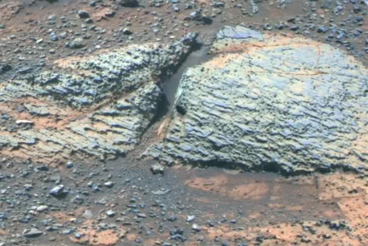
Carbonate-Containing Martian Rocks discovered by Spirit Mars Rover
Spirit collected data in late 2005 which confirmed that the Comanche outcrop contains magnesium iron carbonate, a mineral indicating the past environment was wet and non-acidic, possibly favorable to life. This view was captured during Sol 689 on Mars (Dec. 11, 2005). The find at Comanche is the first unambiguous evidence from either Spirit or Opportunity for a past Martian environment that may have been more favorable to life than the wet but acidic conditions indicated by the rovers’ earlier finds. Credit: NASA/JPL-Caltech/Cornell University
Story updated[/caption]
January 2014 marks the 10th anniversary since the nail biting and history making safe landings of NASA’s renowned Mars Explorations Rovers – Spirit and Opportunity – on the Red Planet barely three weeks apart during January 2004.
Due to their completely unforeseen longevity, a decade of spectacular and groundbreaking scientific discoveries continuously flowed from the robot sisters that have graced many articles, magazine covers, books, documentaries and refereed scientific papers.
What are the Top 10 Decade 1 discoveries from Spirit and Opportunity?
Find out below what a top Mars rover team scientist told Universe Today!
Ray Arvidson, the rovers Deputy Principal Investigator and professor at Washington University in St. Louis, has kindly shared with me his personal list of the Top 10 discoveries from Spirit and Opportunity for the benefit of readers of Universe Today.
The Top 10 list below are Ray’s personal choices and does not necessarily reflect the consensus of the Mars Explorations Rover (MER) team.
First some background.
The dynamic duo were launched on their interplanetary voyages from Cape Canaveral Florida atop Delta II rockets during the summer of 2003.
The now legendary pair landed on opposite sides of the Red Planet. Spirit landed first on Jan. 3 inside Gusev Crater and twin sister Opportunity landed second on Jan. 24 on the dusty plains of Meridiani Planum.
On May 19th, 2005, NASA’s Mars Exploration Rover Spirit captured this stunning view as the Sun sank below the rim of Gusev crater on Mars. This Panoramic Camera (Pancam) mosaic was taken around 6:07 in the evening of Sol 489. The terrain in the foreground is the rock outcrop “Jibsheet,” a feature that Spirit has been investigating for several weeks (rover tracks are dimly visible leading up to “Jibsheet”). The floor of Gusev crater is visible in the distance, and the Sun is setting behind the wall of Gusev some 80 km (50 miles) in the distance. Credit: NASA/JPL-Caltech/Texas A&M/Cornell
The goal was to “follow the water” as a potential enabler for past Martian microbes if they ever existed.
Together, the long-lived, golf cart sized robots proved that early Mars was warm and wet, billions of years ago – a key finding in the search for habitats conducive to life beyond Earth.
The solar powered robo duo were expected to last a mere three months – with a ‘warrenty’ of 90 Martian days (Sols).
Spirit endured the utterly extreme Red Planet climate for more than six years until communications ceased in 2010.
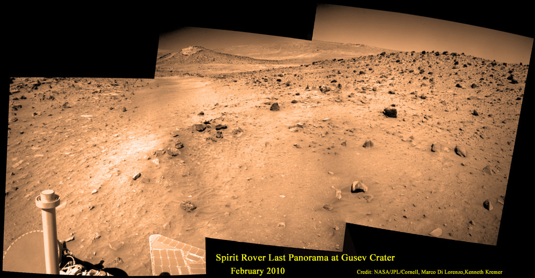
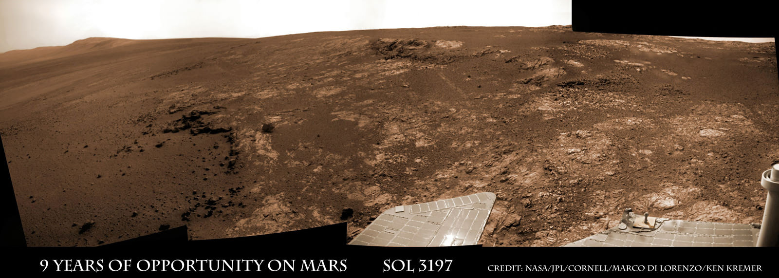
Spirit’s last panorama from Gusev Crater was taken during February 2010 before her death from extremely low temperatures during her 4th Martian winter. Spirit was just 500 feet from her next science target – dubbed Von Braun – at center, with Columbia Hills as backdrop. Mosaic Credit: Marco Di Lorenzo/ Kenneth Kremer/ NASA/JPL/Cornell University.
Mosaic featured on Astronomy Picture of the Day (APOD) on 30 May 2011 – http://apod.nasa.gov/apod/ap110530.html
Opportunity lives on TODAY and is currently exploring by the summit of Solander Point on the western rim of a vast crater named Endeavour that spans some 22 kilometers (14 miles) in diameter.
“Because of the rovers’ longevity, we essentially got four different landing sites for the price of two,” says the rovers’ Principal Investigator, Steve Squyres of Cornell University, Ithaca, N.Y.
Here are the Top 10 MER discoveries from Ray Arvidson, Deputy Principal Investigator
1. Opportunity: Ancient Acidic Martian Lakes
The Meridiani plains Burns formation as sulfate-rich sandstones with hematitic concretions formed in ancient acidic and oxidizing shallow lakes and reworked into sand dunes and cemented by rising groundwaters.
2. Opportunity: Phyllosilicate Clays at ‘Whitewater Lake’ at Endeavour Crater indicate Ancient Habitable Zone
At the rim of Endeavour crater and the Cape York rim segment the discovery of ferric and aluminous smectite [phyllosilicate] clays in the finely-layered Matijevic formation rocks that pre-exist the Endeavour impact event.
Alteration in moderately acidic and reducing waters, perhaps mildly oxidizing for ferric smectites. These are the oldest rocks examined by Opportunity and the waters are much more habitable than waters that led to Burns formation.
3. Opportunity: Martian Meteorites
Many meteorites were found [throughout the long traverse] that are dispersed across the Meridiani plains landing site
4. Opportunity: Wind-blown sand ripples
Wind-blown sand ripples throughout the Meridiani plains relict from the previous wind regime, probably when Mars spin axis tilt was different than today’s value
5. Spirit: Opaline silica indicates Ancient Hydrothermal system
Discovery of Opaline silica at Home Plate, Gusev Crater. This formed in volcanic fumeroles and/or hydrothermal vents indicating that water was interacting with magma.
6. Spirit: Carbonates at Comanche – see lead image above
The discovery of Fe-Mg [iron-magnesium] carbonates at the Comanche outcrop on Husband Hill, Gusev Crater, again showing that water interacted with magma.
Note: Carbonates form in neutral, non-acid water. This was the first time they were found and investigated examined on the surface Mars during Dec. 2005.
7. Spirit: Ferric sulfates moved by modern water
Ferric sulfates moved down the soil column by modern waters at Troy and Husband Hill in Gusev Crater.
8. Spirit: Modern water alters rocks
Complex coatings on olivine basalts on the Gusev Crater plains showing modern water or frost has altered rock surfaces
9. Both rovers: Martian Dust Devils
The finding [and imaging] of dust devil frequency and dynamics, showing how dust and sand are moved by wind in the very thin Martian atmosphere.
Note: Wind action occasionally cleaning off the solar panels led to their unexpected longevity
See a dust devil imaged in our Solander Point mosaic below
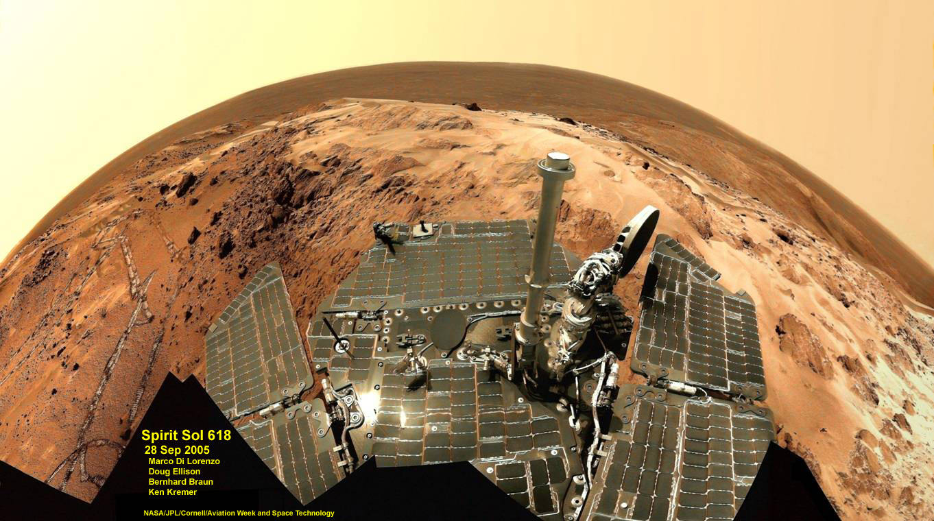
Spirit snapped this unique self portrait view from the summit of Husband Hill inside Gusev crater on Sol 618 on 28 September 2005. The rovers were never designed or intended to climb mountains. It took more than 1 year for Spirit to scale the Martian mountain. This image was created from numerous raw images by an international team of astronomy enthusiasts and appeared on the cover of the 14 November 2005 issue of Aviation Week & Space Technology magazine and the April 2006 issue of Spaceflight magazine. Also selected by Astronomy Picture of the Day (APOD) on 28 November 2005. Credit: NASA/JPL/Cornell/ Marco Di Lorenzo/Doug Ellison/Bernhard Braun/Ken Kremer – kenkremer.com
10. Both rovers: Atmospheric Argon measurements
Argon gas was used as a tracer of atmospheric dynamics by both rovers. It was measured by using the APXS (Alpha Particle X-Ray Spectrometer) on the robotic arm to measure the Martian atmosphere and detect argon
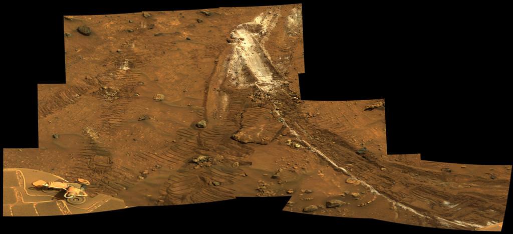
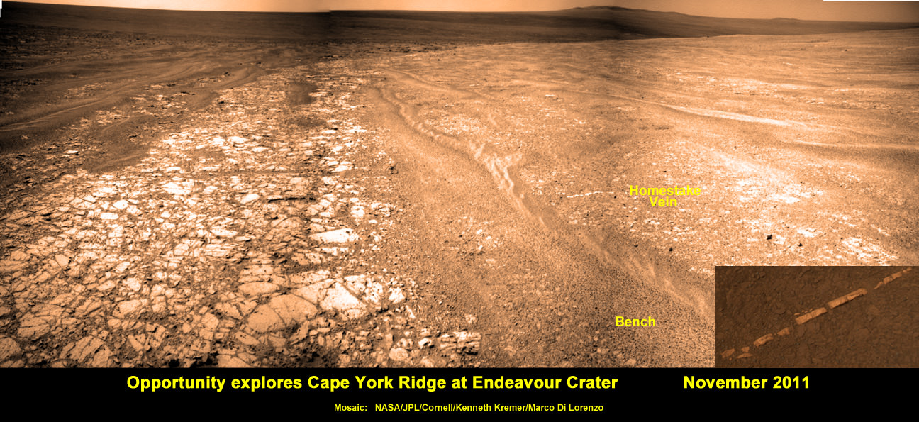
Another major discovery by Opportunity was the finding of hydrated mineral veins of calcium sulfate in the bench surrounding Cape York. The vein discovery is another indication of the ancient flow of liquid water in this region on Mars.
Altogether, Spirit snapped over 128,000 raw images, drove 4.8 miles (7.7 kilometers) and ground into 15 rock targets.
![MER10-SpiritAndOpportunity_ByTheNumbers[1]](https://www.universetoday.com/wp-content/uploads/2014/01/MER10-SpiritAndOpportunity_ByTheNumbers1.jpg)
Opportunity is currently investigating a new cache of exposed clay mineral outcrops by the summit of Solander Point, a rim segment just south of Cape York and Matejivic Hill.
These new outcrops at ‘Cape Darby’ like those at ‘Esperance’ at Matijevic Hill were detected based on spectral observations by the CRISM spectrometer aboard NASA’s Mars Reconnaissance Orbiter (MRO) circling overhead, Arvidson told me.
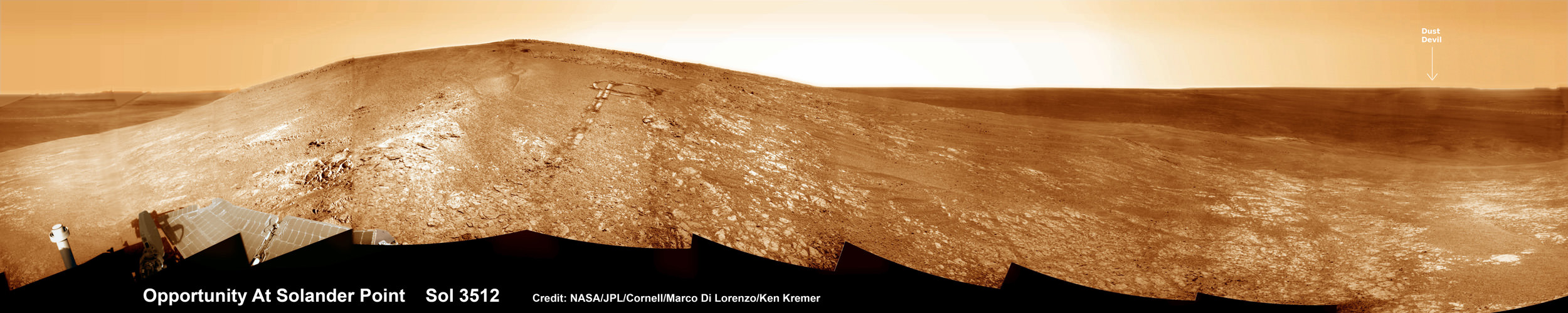
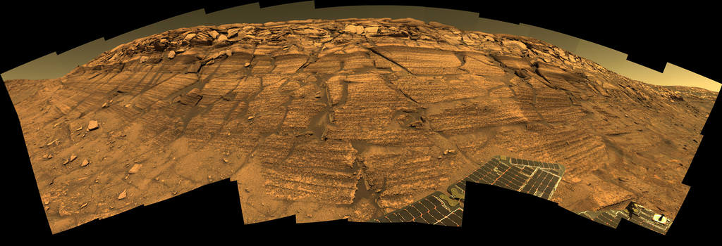
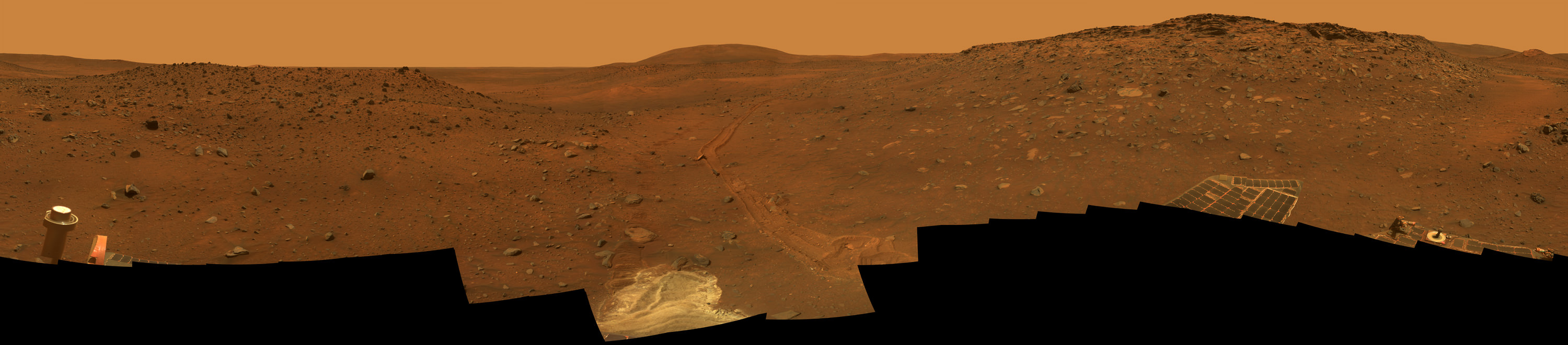
NASA’s Opportunity rover captured this panoramic mosaic on Dec. 10, 2013 (Sol 3512) near the summit of “Solander Point” on the western rim of vast Endeavour Crater where she starts Decade 2 on the Red Planet. She is currently investigating summit outcrops of potential clay minerals formed in liquid water on her 1st mountain climbing adventure. See wheel tracks at center and dust devil at right. Assembled from Sol 3512 navcam raw images. Credit: NASA/JPL/Cornell/Marco Di Lorenzo/Ken Kremer-kenkremer.com
Today, Jan. 31, marks Opportunity’s 3563rd Sol or Martian Day roving Mars – for what was expected to be only a 90 Sol mission.
So far she has snapped over 188,200 amazing images on the first overland expedition across the Red Planet.
Her total odometry stands at over 24.07 miles (38.73 kilometers) since touchdown on Jan. 24, 2004 at Meridiani Planum.
Read more about sister Spirit – here and here.
Meanwhile on the opposite side of Mars, Opportunity’s younger sister rover Curiosity is trekking towards gigantic Mount Sharp. She celebrated 500 Sols on Mars on New Years Day 2014.
And a pair of new orbiters are streaking to the Red Planet to fortify Earth’s invasion fleet- NASA’s MAVEN and India’s MOM.
What’s Ahead for Opportunity in Decade 2 on Mars ?
Many more ground breaking discoveries surely lie ahead for Opportunity since she is currently exploring ancient terrain at Endeavour crater that’s chock full of minerals indicative of a Martian habitable zone.
She remains healthy and the solar panels are generating enough power to actively continue science investigations throughout her 6th frigid Martian winter!

Therefore – Stay tuned here for Ken’s continuing Opportunity, Curiosity, Chang’e-3, LADEE, MAVEN, Mars rover and MOM news.
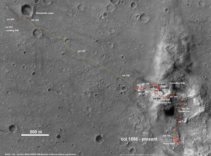

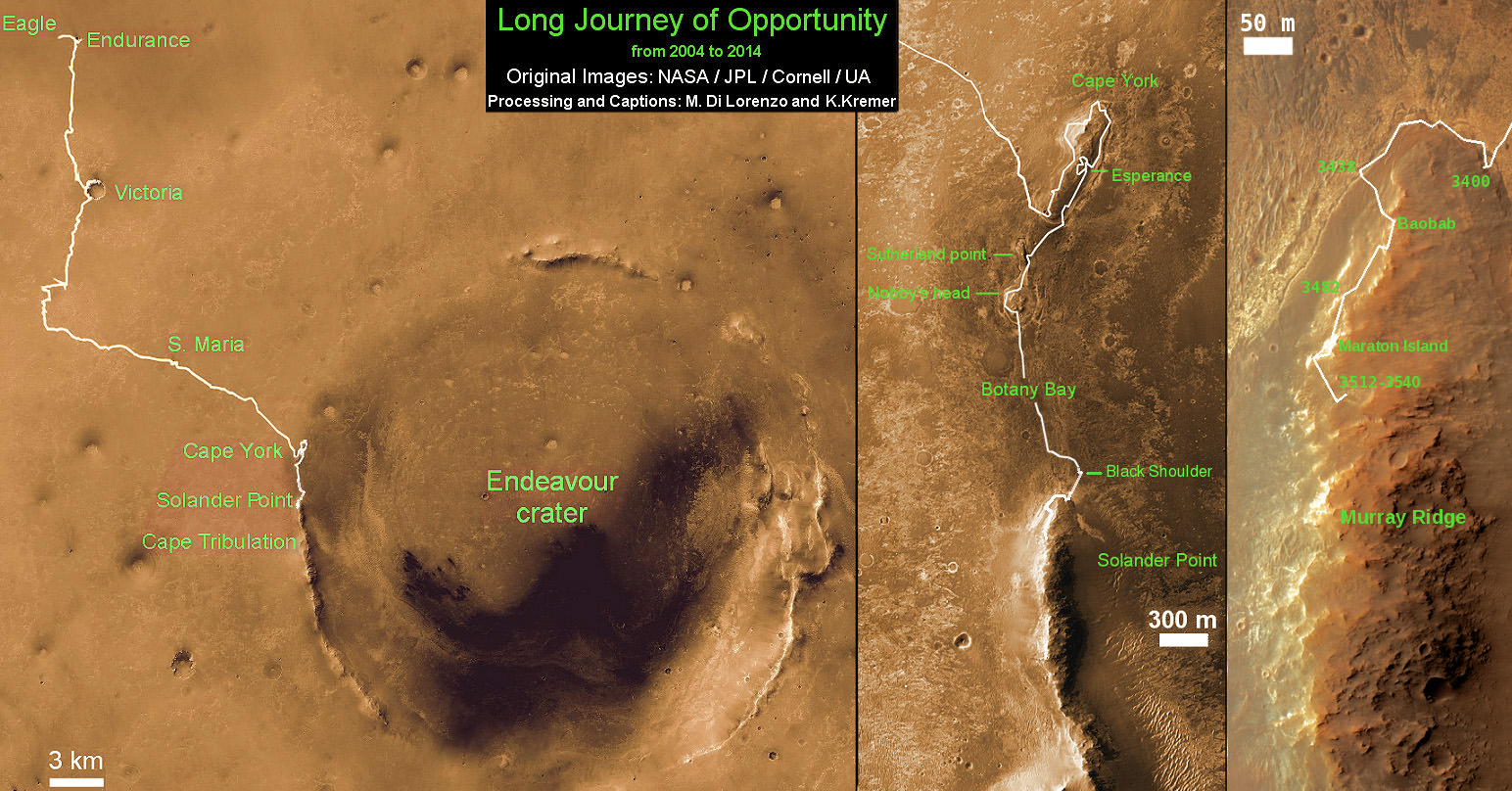
This map shows the entire path the rover has driven during a decade on Mars and over 3560 Sols, or Martian days, since landing inside Eagle Crater on Jan 24, 2004 to current location by Solander Point summit at the western rim of Endeavour Crater. Rover will spend 6th winter here atop Solander. Opportunity discovered clay minerals at Esperance – indicative of a habitable zone. Credit: NASA/JPL/Cornell/ASU/Marco Di Lorenzo/Ken Kremer – kenkremer.com