It’s time once again for this week’s Where In The Universe challenge. Take a look at the image above and try to determine where in the universe this image was taken. Give yourself extra points if you can name the spacecraft responsible for taking this image. As always, no peeking below before you make your guess. And comments are welcome if you want to share how well you did!
Make your guess, and then proceed.
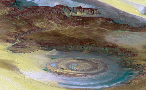
This prominent circular feature, known as the Richat Structure, is found on our home planet Earth, in the Sahara Desert. Lots of astronauts have noted it and taken pictures of it because it forms a conspicuous 50-kilometer-wide (30-mile-wide) bullet’s-eye on the otherwise rather featureless expanse of the desert. Initially it was thought to be an impact crater, but it is now known to be an eroded circular anticline (structural dome) of layered sedimentary rocks.
This image was generated from a Landsat satellite image draped over an elevation model produced by the Shuttle Radar Topography Mission (SRTM), so if you said either a satellite or an astronaut took this image, you can consider yourself correct. The view uses a 6-times vertical exaggeration to greatly enhance topographic expression. To give a scale for this image, the height of the mesa ridge in the back center of the view is about 285 meters (about 935 feet) tall. This is a color enhanced image, using both visible and infrared bands, which helps to differentiate bedrock (browns), sand (yellow, some white), minor vegetation in drainage channels (green), and salty sediments (bluish whites). Some shading of the elevation model was included to further highlight the topographic features.
This is quite a striking image from the old home planet.
See a hi-resolution image here.
Source: NASA Earth Observatory

