Comet 41P glows green (left) and shows its true coma and just the hint of a stubby tail in the negative (red) image (right) from March 19th. Image credit and copyright: Hisayoshi Kato
Comet 41P Tuttle-Giacobini-Kresák glows green (left) and shows its true coma and just the hint of a stubby tail in the negative (red) image (right) from March 19th. Image credit and copyright: Hisayoshi Kato
Miss out on comet 45P Honda-Mrkos-Pajdušáková? Is Comet 2P Encke too low in the dawn sky for your current latitude? Well, the Universe is providing us northerners with another shot at a fine binocular comet, as 41P Tuttle-Giacobini-Kresák glides through Ursa Major this week.
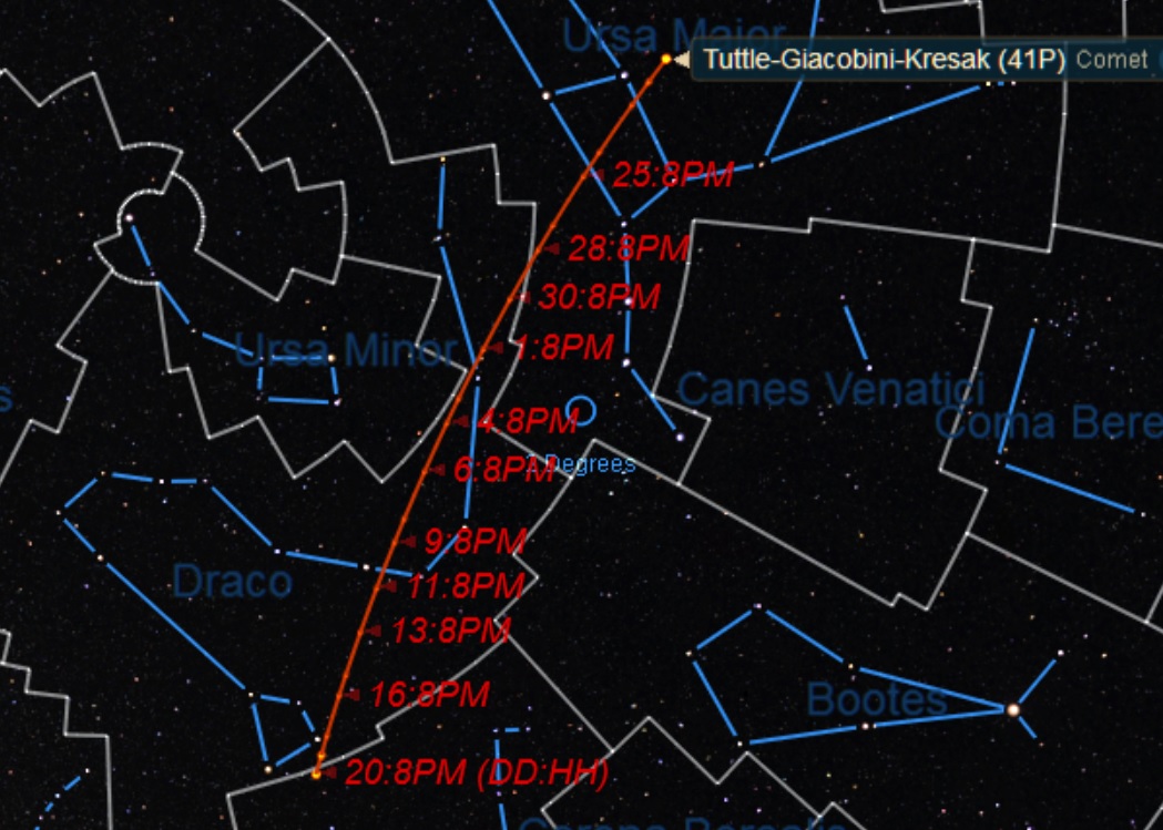
As seen from 30 degrees north, Comet 41P Tuttle-Giacobini-Kresák (sometimes called “Comet 41P” or “Comet TGK”) starts the last week of March about 40 degrees above the NE horizon at 9PM local. It then makes the plunge below 30 degrees elevation on April 1st for the same latitude at the same time. At its closest on April 5th, the comet will be moving at two degrees a day (the width of four Full Moons!) as seen from the Earth as it slides down through the snaky constellation of Draco.
The path of Comet 41P from March 20th through April 20th. Credit: Starry Night.
The comet reaches an elevation of 10 degrees for evening viewers around April 15th, and passes 10 degrees north of another up and coming binocular comet C/2015 V2 Johnson right around the same date. After early April, your odds get better to see Comet 41P Tuttle-Giacobini-Kresák high in the sky at its upper culmination past local midnight towards dawn.
There’s another reason to try and recover this comet this week, as the Moon is now a waning crescent headed towards New on March 28th. From there, the waxing Moon begins to interfere with cometary observations as it heads towards the Easter Full Moon on April 11th, pushing efforts to recover and follow the comet towards pre-dawn hours.
First discovered by astronomer Horace Tuttle 1858, the comet was independently recovered by Michel Giacobini in 1907 and L’ubor Kresák in 1951 and its periodic nature was uncovered.
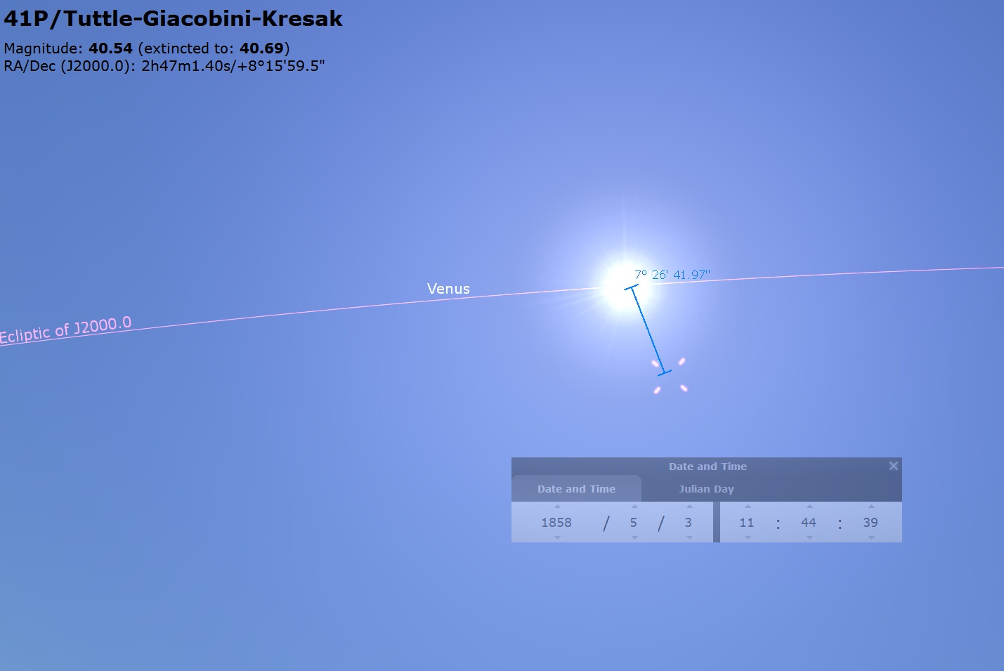
Note: We believe that the “May 3rd, 1858” date given for the discovery of this comet around ye ole Web is in fact, erroneous, as both Stellarium and Starry Night put the comet just a few degrees from the Sun on this date! Perhaps both programs are wrong looking that far back in time… but they’re both exactly wrong. Perhaps a bit of astronomical detective work is in order? More to come!
Due for a revision? Here’s the position of Comet 41P Tuttle-Giacobini-Kresák on the oft quoted discovery date of May 3rd, 1858… just 8 degrees from the Sun! Credit: Stellarium.
Orbiting the Sun once every 5.4 years, this is the 29th perihelion return of the comet since its discovery in 1858. The comet’s orbit takes it from 5.1 AU, out to near the orbit of Jupiter, to a perihelion just 0.13 AU outside the orbit of the Earth. This year’s passage is nearly as close as the comet can approach the Earth, with solar opposition also occurring on April 5th. The comet’s orbit is inclined about nine degrees to the ecliptic plane. Think of the comet zipping down over the northern hemisphere of the Earth, reaching perihelion as it heads from north to south, then headed back out over the southern hemisphere.
Currently at +9th magnitude, the comet should flirt with naked eye visibility of magnitude +6 in early April. This comet is also worth watching, as it’s known for periodic outbursts. Flashback to 1973, and Comet 41P Tuttle-Giacobini-Kresák made an easy naked eye apparition of +4. This is also the closest approach of Comet 41P Tuttle-Giacobini-Kresák near the Earth in our lifetimes, and the closest in the two century span from 1900 to 2100.
The projected light curve for Comet 41P Tuttle-Giacobini-Kresák. The pink line denotes perihelion, at the black dots mark recorded magnitude estimates. Adapted from Seiichi Yoshida’s Weekly Information About Bright Comets.
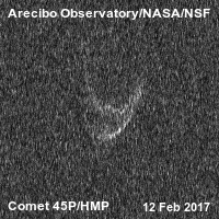
Arecibo did ping 41P Tuttle-Giacobini-Kresák in early March, but probably won’t image the comet near perihelion due to its northerly declination (Arecibo is only partially steerable). They did, however nab a great animation of the twin lobbed Comet 45P Honda-Mrkos-Pajdušáková on February 12th:
An amazing view: Comet 45P Honda-Mrkos-Pajušáková pinged by Arecibo radar last month. Credit: Arecibo/USRA
That makes two, bi-bulbous comets, if you include Comet 67P Churyumov-Gerasimenko. Are twin-lobbed comets in fact as common as comet-hunters with umlauts in their name?
Here are some key highlight events for Comet 41P Tuttle-Giacobini-Kresák to watch out for. Close passes are less than one degree unless otherwise noted:
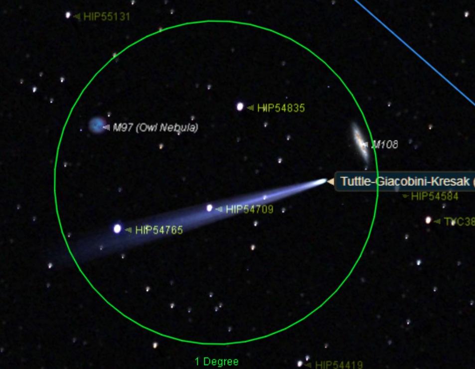
March 21st: Photo-op: passes between M108 and M97 the Owl Nebula March 29th: passes into Draco April 2nd: Passes near the 3.6 magnitude star Thuban (Alpha Draconis) April 5th: Passes just 0.15 AU (23.2 million kilometers) from the Earth at 13:30 UT. April 7th: passes just 22 degrees from the north celestial pole at declination 68 degrees north. April 11th: reaches perihelion at 1.05 AU (162.7 million kilometers) from the Sun. April 18th: passes the 2.7 magnitude star Rastaban (Beta Draconis) April 20th: passes into the constellation Hercules
The comet vs two Messier objects: the view on March 22nd at 12:00 UT. Credit: Starry Night
Observing comets is an exercise in patience, as that quoted magnitude is often smeared out over an extended area. Dark skies and a good star chart are key. I like to use binoculars when hunting for comets brighter than +10th magnitude, as it gives you a true (un-inverted both up/down and left to right) view, coupled with a generous field of view.
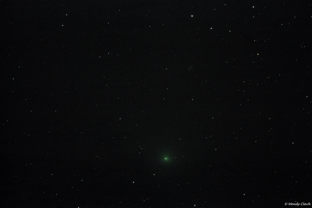
Comet 41P Tuttle-Giacobini-Kresák from March 15th. Image credit and copyright: Wendy Clark.
If Comet 41P Tuttle-Giacobini-Kresák outperforms into the +6th magnitude range or brighter, it could become a fine target to image with foreground objects. We’re already seeing some amazing images streaming in, with more to come as perihelion approaches.
Other binocular comets to watch for in 2017 include C/2015 ER61 PanSTARRS (May) and C/2015 V2 Johnson (June).
If Comet 41P Tuttle-Giacobini-Kresák performs at or above expectations (and if no great “comet(s) of the century show up!) it could be the best binocular comet of 2017. Don’t miss it!
-Send those images to Universe Today’s Flickr page.
-Be sure to read about the brightest comets of the year and more in our 2017 Astronomical Guide, free from Universe Today.
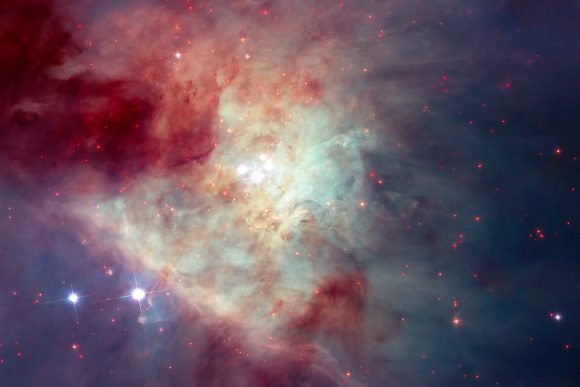
The stunning, shaped clouds of gas in the Orion Nebula make it beautiful, but also make it difficult to see inside of. This image of the Orion Nebula was captured by the Hubble Telescope. Image: NASA, ESA, M. Robberto (STScI/ESA) and
The Hubble Space Telescope Orion Treasury Project Team
It sometimes doesn’t take much to tear a family apart. A Christmas dinner gone wrong can do that. But for a family of stars to be torn apart, something really huge has to happen.
The dramatic break-up of a family of stars played itself out in the Orion Nebula, about 600 years ago. The Orion Nebula is one of the most studied objects in our galaxy. It’s an active star forming region, where much of the star birth is concealed behind clouds of dust. Advances in infrared and radio astronomy have allowed us to peer into the Nebula, and to watch a stellar drama unfolding.
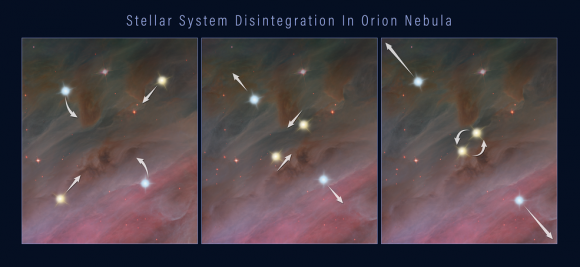
This three-frame illustration shows how a grouping of stars can break apart, flinging the members into space. Panel 1: members of a multiple-star system orbiting each other. Panel 2: two of the stars move closer together in their orbits. Panel 3: the closely orbiting stars eventually either merge or form a tight binary. This event releases enough gravitational energy to propel all of the stars in the system outward, as shown in the third panel. Credits: NASA, ESA, and Z. Levy (STScI)
Over the last few decades, observations showed the two of the stars in our young family travelling off in different directions. In fact, they were travelling in opposite directions, and moving at very high speeds. Much higher than stars normally travel at. What caused it?
Astronomers were able to piece the story together by re-tracing the positions of both stars back 540 years. All those centuries ago, around the same time that it was dawning on humanity that Earth revolved around the Sun instead of the other way around, both of the speeding stars were in the same location. This suggested that the two were part of a star system that had broken up for some reason. But their combined energy didn’t add up.
Now, the Hubble has provided another clue to the whole story, by spotting a third runaway star. They traced the third star’s path back 540 years and found that it originated in the same location as the others. That location? An area near the center of the Orion Nebula called the Kleinmann-Low Nebula.
This composite image of the Kleinmann-Low Nebula, part of the Orion Nebula complex, is composed of several pointings of the NASA/ESA Hubble Space Telescope in optical and near-infrared light. Infrared light allows to peer through the dust of the nebula and to see the stars therein. The revealed stars are shown with a bright red colour in the image. With this image, showing the central region of the Orion Nebula, scientists were looking for rogue planets and brown dwarfs. As side-effect they found a fast-moving runaway star. By ESA/Hubble, CC BY 4.0, https://commons.wikimedia.org/w/index.php?curid=57169218
The team behind these new results, led by Kevin Luhman of Penn State University, will release their findings in the March 20, 2017 issue of The Astrophysical Journal Letters.
“The new Hubble observations provide very strong evidence that the three stars were ejected from a multiple-star system,” said Luhman. “Astronomers had previously found a few other examples of fast-moving stars that trace back to multiple-star systems, and therefore were likely ejected. But these three stars are the youngest examples of such ejected stars. They’re probably only a few hundred thousand years old. In fact, based on infrared images, the stars are still young enough to have disks of material leftover from their formation.”
Young stars have a disk of gas and dust around them called a protoplanetary disk. Credit: NASA/JPL-Caltech
“The Orion Nebula could be surrounded by additional fledging stars that were ejected from it in the past and are now streaming away into space.” – Lead Researcher Kevin Luhman, Penn State University.
The three stars are travelling about 30 times faster than most of the Nebula’s other stellar inhabitants. Theory has predicted the phenomenon of these breakups in regions where newborn stars are crowded together. These gravitational back-and-forths are inevitable. “But we haven’t observed many examples, especially in very young clusters,” Luhman said. “The Orion Nebula could be surrounded by additional fledging stars that were ejected from it in the past and are now streaming away into space.”
The key to this mystery is the recently discovered third star. But this star, the so-called “source x”, was discovered by accident. Luhman is part of a team using the Hubble to hunt for free-floating planets in the Orion Nebula. A comparison of Hubble infrared images from 2015 with images from 1998 showed that source x had changed its position. This indicated that the star was moving at a speed of about 130,000 miles per hour.
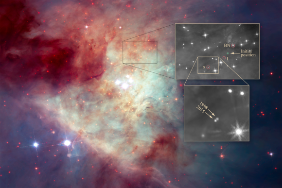
The image by NASA’s Hubble Space Telescope shows a grouping of young stars, called the Trapezium Cluster (center). The box just above the Trapezium Cluster outlines the location of the three stars. A close-up of the stars is top right. The birthplace of the multi-star system is marked “initial position.” Two of the stars — labeled BN, and “I,” for source I — were discovered decades ago. Source I is embedded in thick dust and cannot be seen. The third star, “x,” for source x, was recently discovered to have moved noticeably between 1998 and 2015, as shown in the inset image at bottom right. Credits: NASA, ESA, K. Luhman (Penn State University), and M. Robberto (STScI)
Luhmann then re-traced source x’s path and it led to the same position as the other 3 runaway stars 540 years ago: the Kleinmann-Low Nebula.
According to Luhmann, the three stars were most likely ejected from their system due to gravitational fluctuations that should be common in a high-population area of newly-born stars. Two of the stars can come very close together, either forming a tight binary system or even merging. That throws the gravitational parameters of the system out of whack, and other stars can be ejected. The ejection of those stars can also cause fingers of matter to flow out of the system.
As we get more powerful telescopes operating in the infrared, we should be able to clarify exactly what happens in areas of intense star formation like the Orion Nebula and its embedded Kleinmann-Low Nebula. The James Webb Space Telescope should advance our understanding greatly. If that’s the case, then not only will the details of star birth and formation become much clearer, but so will the break up of young families of stars.
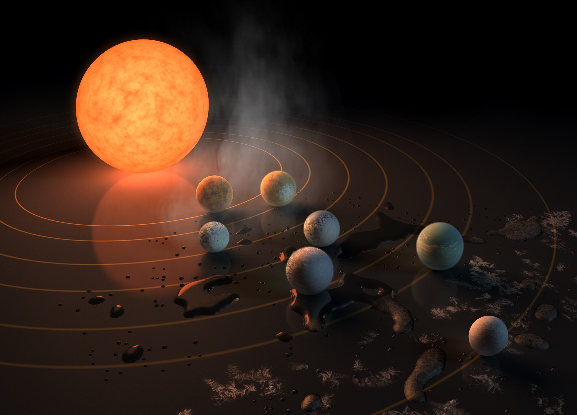
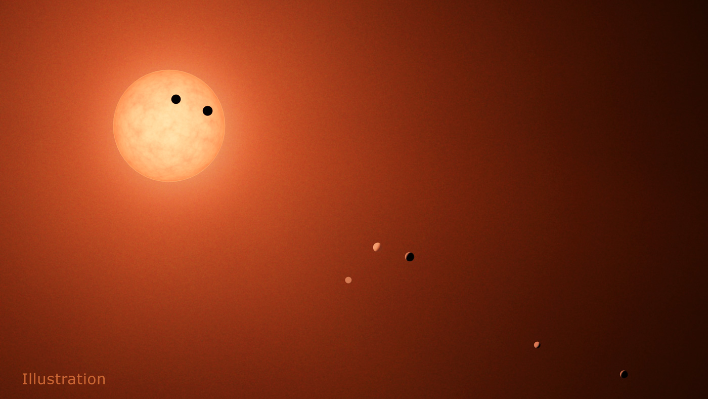
Artist's concept of the TRAPPIST-1 star system, an ultra-cool dwarf that has seven Earth-size planets orbiting it. We're going to keep finding more and more solar systemsl like this, but we need observatories like WFIRST, with starshades, to understand the planets better. Credits: NASA/JPL-Caltech
In case you haven’t heard, some new potentially habitable planets were discovered, and they’re named after beer. To celebrate two of our favorite things finally coming together, Forbidden Brewing Co. welcomes local space expert Fraser Cain for an evening of space talk, beer, and pizza.
The newly discovered planets are called the TRAPPIST-1 planets, and they’re named after a type of beer brewed by Belgian Trappist Monks. The knowledgeable and entertaining Fraser Cain will host the evening, and will answer your questions about these fascinating planets and their star.
Whether you’re just curious, or you’re a bona fide astronomy nerd, this is a great opportunity to rub shoulders with others who share your curiosity. And your love of beer.
A mug of beer. Mmmmm… Image: http://twitter.com/aizek https://creativecommons.org/licenses/by/2.0/
Fraser Cain is a lifelong Comox Valley resident, and is the publisher of Universe Today, a popular space and astronomy website. In honor of the planets-named-after-Belgian-beer, Forbidden Brewing will be serving their Belgian Saison, (which we can confirm as a great beer!) There will also be food available.
This fun and fact-filled evening will be held at the Forbidden Brewing Company on Cliffe Avenue in Courtenay, Vancouver Island, BC, on March 29th at 6:30 PM.
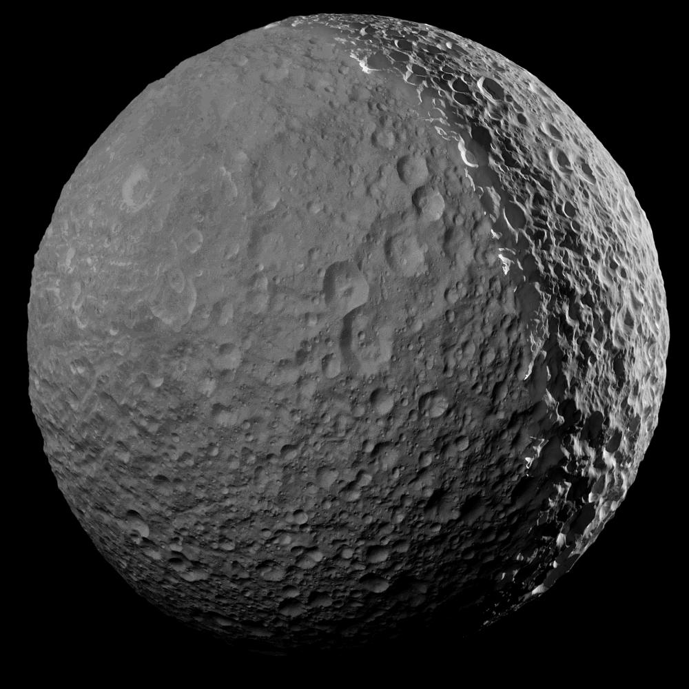
Mosaic view of Mimas, created using images taken by the Cassini probe (and illuminated to show the full surface). Credit: NASA/JPL-Caltech/Space Science Institute
Since the Cassini mission arrived in the Saturn system in 2004, it has provided some stunning images of the gas giant and its many moons. And in the course of capturing new views of Titan’s dense atmosphere, Iapetus’ curious “yin-yang” coloration, and the water plumes and “tiger stripes” of Enceladus, it snapped the most richly-detailed images of Mimas ever seen.
But like all good things, Cassini’s days of capturing close-up images of Mimas are coming to an end. As of January 30th, 2017, the probe made its final close approach to the moon, and took the last of it’s close-up pictures in the process. In the future, all observations (and pictures) of Mimas will take place at roughly twice this distance – and will therefore be less detailed.
To be fair, these close approaches were a pretty rare event during the Cassini mission. Over the course of the thirteen years that the probe has been in the Saturn system, only seven flybys have taken place, occurring at distances of less 50,000 km (31,000 mi). At its closest approach, Cassini passed within 41,230 km (25,620 mi) of Mimas.
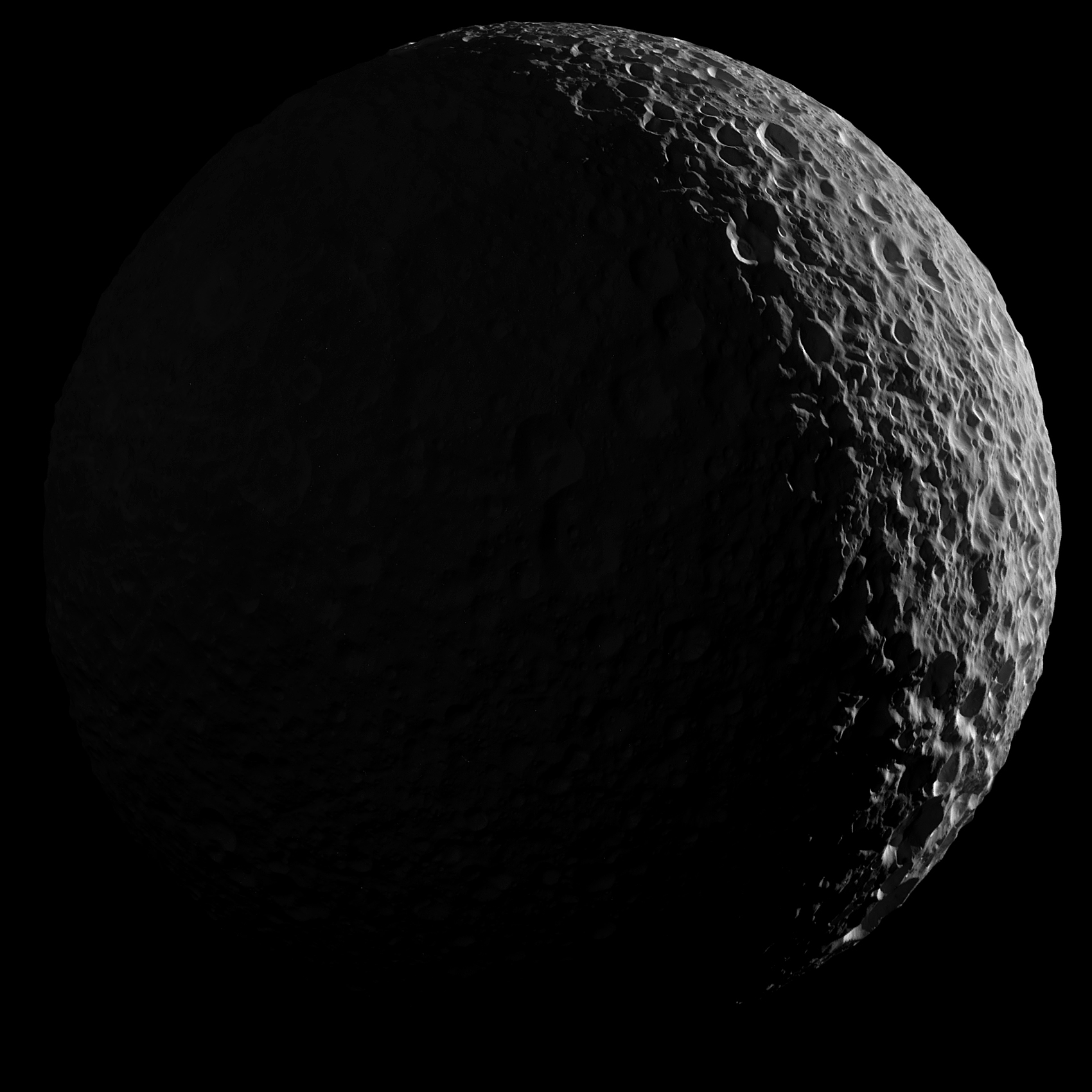
Second mosaic view of Mimas, showing illumination on only the Sun-facing side. Credit: NASA/JPL-Caltech/Space Science Institute
During this time, the probe managed to take a series of images that allowed for the creation of a beautiful mosaic. This mosaic was made from ten combined narrow-angle camera images, and is one of the highest resolution views ever captured of the icy moon. It also comes in two versions. In one, the left side of Mimas is illuminated by the Sun and the picture is enhanced to show the full moon (seen at top).
In the second version (shown above), natural illumination shows only the Sun-facing side of the moon. They also created an animation that allows viewers to switch between mosaics, showing the contrast. And as you can see, these mosaics provide a very detailed look at Mimas heavily-cratered surface, a well as the large surface fractures that are believed to have been caused by the same impact that created the Herschel Crater.
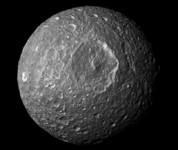
This famous crater, from which Mimas gets it’s “Death Star” appearance, was photographed during Cassini’s first flyby – which occurred on February 13th, 2010. Named in honor of William Herschel (the discoverer of Uranus, its moons Oberon, and Titania, and Saturn’s moons Enceladus and Mimas), this crater measures 130 km (81 mi) across, almost a third of Mimas’ diameter.
This mosaic, created from images taken by NASA’s Cassini spacecraft during its closest flyby of Saturn’s moon Mimas, looks straight at the moon’s huge Herschel Crater Credit: NASA/JPL
Its is also quite deep, as craters go, with walls that are approximately 5 km (3.1 mi) high. Parts of its floor reach as deep as 10 km (6.2 mi), and it’s central peak rises 6 km (3.7 mi) above the crater floor. The impact that created this crater is believed to have nearly shattered Mimas, and also caused the fractures visible on the opposite side of the moon.
It’s a shame we won’t be getting any more close ups of the moon’s many interesting features. However, we can expect a plethora of intriguing images of Saturn’s rings, which it will be exploring in depth as part of the final phase of its mission. The mission is scheduled to end on September 15th, 2017, which will culminate with the crash of the probe in Saturn’s atmosphere.
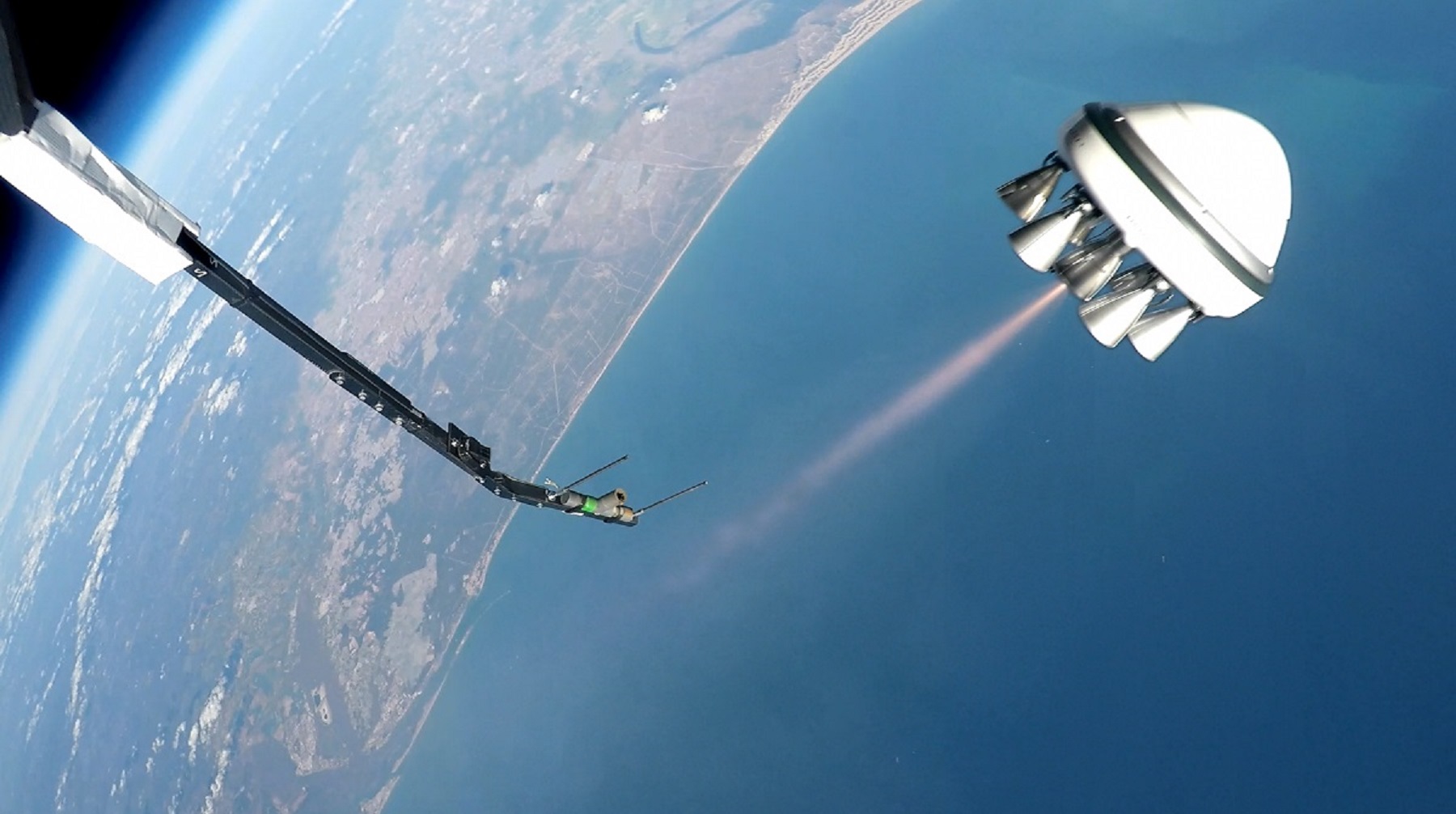
Zero 2 Infinity's Bloostar being deployed from a balloon 25 km (15.5 mi) above the coast of Spain. Credit: zero2infinity.space
Founded in 2009, the private aerospace company Zero2Infinity – which is headquartered in Barcelona, Spain – was created with the vision of delivering orbital payloads and providing space tourism on a budget. But unlike your conventional aerospace companies – i.e. SpaceX, Blue Origin, Orbital ATK, etc – their plan is to do it all using high-altitude stratospheric balloons.
On March 1st, the Zero2Infinity team passed a major milestone, deploying a prototype “rockoon” craft from the National Institute of Aerospace Technology‘s (INTA) facility in El Arenosillo, Spain. Known as Bloostar, this two-stage craft (which consists of a balloon and a rocket) is one of the latest technologies seeking to drastically reduce the costs of launching people and payloads into space.
As the name would suggest, the Bloostar craft consists of a first-stage balloon that carries a launch vehicle to altitudes of about 40 km (25 mi), where it is then engages its engine. By bringing a rocket to an attitude that is twice the cruising altitude of commercial aircraft, rockoons are capable of reducing the size of rockets and the amount of propellant needed to place payloads into orbit.
The launch vehicle itself is composed of a set of liquid fuel engines that are arranged in a concentric torus-configuration, which are then attached to the central payload. Each torus works as a stage during the rocket’s ascent, which are ignited once it reaches deployment altitude. After all the rocket stages are are finished deploying the payload, they all return to Earth with the balloon where they are recovered.
In this respect, the Bloostar employs technology that is similar to what United Launch Alliance is exploring with the proposed mid-air recovery of their Vulcan rockets’ engines. But the largest cost-cutting measure arises from the fact that the ignition phase does not start until the rocket is at an altitude that puts its beyond 95% of the mass of the Earth’s atmosphere.
This also allows for additional flexibility with launches since it means getting above inclement weather, and also ensures that polluting emissions are not added to the lower atmosphere. The use of several torus-shaped stages reduces the chance of damage occurring to the launch vehicle on re-entry, since several small stages experience less in the way of air friction and heat than larger rocket states.
There is the added benefit of there being less chance of damage. Oftentimes, satellites have fold-out solar panels and science instruments that have to be tucked away to be able to fit inside the cargo hold of a launch vehicle. But with the Bloostar, they can be attached to the flat front end, and will experience less in the way of launch stress since they are floated into space instead of accelerated to escape velocity.
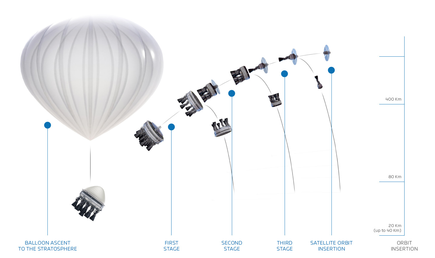
Diagram showing the various stages in the launch of he Bloostar. Credit: zero2infinity.space
For the sake of their test flight, the Bloostar’s first-stage was elevated to an altitude of 25 km (15.5 mi) above sea level, a little over halfway towards their maximum deployment height. Once there, the launch vehicle conducted a successful ignition test. In addition to being a crucial milestone in the development of the prototype, the flight provided an opportunity to test several key subsystems and steps that will come into play.
These included the craft’s telemetry systems, which needed to be tested in space. There was also the controlled ignition sequence and stabilization systems of the rocket, the launch sequence, the deployment of its parachute deployment, and finally, recovery of the engines at sea. And according to a news release issued by the company on Monday, March 13th, “All these goals were achieved in full.”
This test was a first for the aerospace industry, as Zero2Infinity is currently the only company using stratospheric balloons as a first-stage vehicle. And already, the company states that it has garnered its fair share of interest from leading satellite developers, claiming that they have “gathered upwards of 250 million Euros in Letters of Intent for future launches.”
In addition to Bloostar, the company also has a space tourism program in the works. Known as “Bloon“, this service will offer clients the ability to travel to near-space aboard a stratospheric balloon for a chance to see Earth from suborbit. The purpose here is not just leisure, but to inspire people to appreciate the planet as a whole and help to protect it.
And then there’s Elevate, which is the company’s service for launching communications and weather-monitoring satellites, science experiments, stratospheric platforms, and other payloads to sub-orbital space. One of the more interesting packages they deployed in recent years was a Barbie doll in October of 2016, as part of Mattel’s “Barbie to Space” PR campaign.
There is no doubt that the commercial aerospace sector (aka. NewSpace) plays an important role in the era of renewed space exploration. Whereas the Space Race was characterized by fierce competition between two rival superpowers and their respective federal space agencies, the new era is characterized by cooperation between multiple space agencies and (for he most part) healthy competition in the private sector.
With the development of reusable rockets, reusable launch components, and now reusable “rockoons”, the costs of exploiting Low-Earth Orbit are dropping, and space itself is becoming far more accessible.
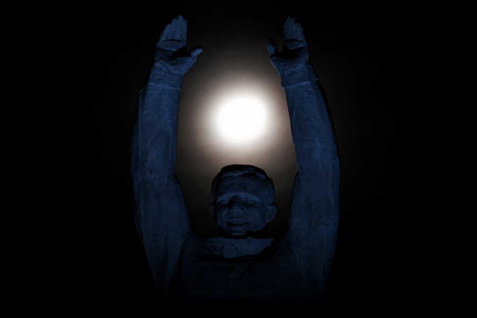
Statue of Yuri Gagarin, the first man in space, at the Baikonur Cosmodrome. Credit: AFP
Roscosmos has certainly come a long way in the past few decades. After facing an uncertain future in the 1990s, the federal space agency has rebounded to become a major player in space and a crucial partner in the International Space Station. And in the coming years, Roscosmos hopes to expand its reach further, with missions planned to the Moon and even Mars.
Towards this end, on Tuesday, March 14th, the agency announced that it is conducting a recruitment drive for new cosmonauts. All are welcome, the agency stressed, to apply to become the next-generation of space explorers (provided they meet the criteria). And if all goes as planned, a few lucky applicants will be the first members of the Russian space program to “fly to the Moon.”
Understandably, Roscosmos is hoping to jump start its space exploration program again and recapture the momentum it enjoyed during the Soviet Era. In addition to Sputnik and sending the first man and woman into space (as part of the Vostok program), the Soviet space program also produced a reusable spacecraft by the 1980s that was similar to the Space Shuttle (known as the Buran program).
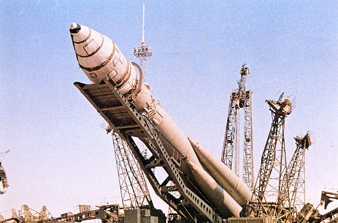
Rollout and Erection of Vostok 1, the flight that took the first man (Yuri Gagarin) into space on April 12th, 1961. Credits: alldayru.com
Unfortunately, with budget cuts during this decade and the fall of the Soviet Union in 1991, several changes had to be made. For one, Roscosmos needed to turn to commercial satellite launches and space tourism in order to make up the difference in its funding. In addition, some observers have cited how Russia’s financial commitment to the ISS has had a detrimental effect on other programs.
It is little wonder then why Russian wants to embark on some serious missions in the coming decades, ones which will reestablish it as a leader in space exploration. Intrinsic to this is a proposed crewed mission to the Moon, which is scheduled to take place in 2031. Roscosmos has also been developing the next-generation spacecraft that will replace the Soyuz-TMA, which has been the workhorse of the space program since the Soviet era.
Known as the the Federatsiya (Federation) capsule, this vehicle is scheduled to make its first crewed flight to space sometime in 2023 from the Vostochny cosmodrome in the Russian far east. As you can see from the images, it bears a striking resemblance to the Orion capsule. Unveiled at the 12th International Aviation and Space Salon in Moscow (MAKS-2015), this capsule will carry the first Russian cosmonauts to the Moon.
All they need now is fresh blood to make the journey. Hence why they are conducting their first recruitment drive in five years, which is the second drive to be is open to all people – not just military pilots, but also those working in the space industry. This time around, Roscosmos is looking for 6 to 8 new recruits who will train in how to fly the next-generation spaceships and make Russia’s long-awaited lunar landing.
The Federatsiya crew capsule being unveiled at the 12th International Aviation and Space Salon in Moscow. Credit: Wikipedia Commons/Roscosmos
As Sergei Kiralyov (Roscosmos’ Executive Director of Manned Programs) was quoted by RIA Novosti as saying, “There will be no discrimination based on skin colour or gender.” The criteria for these applicants include an age limit of 35, a height of between 1 m 50 cm – 1 m 90 cm (4’11” and 6’2″), and a weight of no more than 90 kilograms (~198 pounds).
The criteria also stress physical fitness, and claim that applicants must be able to cross-country ski for 5 km (~3 mi). They must also pass a series of psychological and physical tests (which include gynaecological examinations for women). In terms of skills, Roscosmos is seeking individuals who have an engineering degree, pilot training, experience in the aviation industry, and IT skills. Knowledge of a foreign language is also a plus (other than Russian, of course!).
“Recruitment of cosmonauts will take place starting from today, March 14, will take place before the end of the year. The results would be summed up in the end of December,” said Roscosmos’ First Deputy Director General Alexander Ivanov. Roscosmos also stressed that all those who are interested must apply by post or in person at the Star City astronaut training center outside Moscow (with three passport-sized photos included).
So if you speak Russian, are interesting in becoming part of the next-generation of cosmonauts, meet the requirements, or just want to go to the Moon, you might want to consider throwing your hat into the ring! Down the road, Roscosmos also has plans to conduct crewed missions to Mars between 2040 and 2060. These are expected to take place only after missions to the Moon are complete, which may include the creation of a lunar outpost.
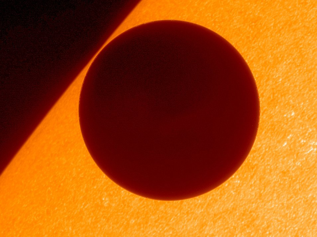
On June 5th, 2012, the NASA/JAXA Hinode mission captured these stunning views of the transit of Venus. Credit: JAXA/NASA/Lockheed Martin
Earth and Venus are often called “sister planets” because they share some key characteristics. Like Earth, Venus is a terrestrial planet (i.e. composed of silicate minerals and metals) and orbits within our Sun’s habitable zone. But of course, they are also some major differences between them, like the fact that Venus’ is atmosphere is extremely dense and the hottest in the Solar System.
This is particularly interesting when you consider that Venus is not the closest planet to our Sun (that would be Mercury). In fact, its distance from the Sun is just over 70% the distance between Earth and the Sun. And due to its low eccentricity, there is very little variation in its distance during the course of its orbital period.
Perihelion and Aphelion:
While all planets follow an elliptical orbit, Venus’s orbit is the least eccentric of any of the Solar Planets. In fact, with an eccentricity of just 0.006772 , its orbit is the closest to being circular of any of the planets. It’s average distance (semi-major axis) from the Sun is 108,208,000 km (67,237,334 mi), and ranges from 107,477,000 km (66,783,112 mi) at perihelion to 108,939,000 km (67,691,556 mi) at aphelion.
Earth and Venus’ orbit compared. Credit: Sky and Telescope
To put it another way, Venus orbits the Sun at an average distance of 0.723 AU, which ranges from 0.718 AU at its closest to 0.728 AU at its farthest. Compare this to Earth’s eccentricity of 0.0167, which means that it orbits the Sun at an average distance of 1 AU, and that this distance ranges between 0.983 and 1.0167 AUs during its orbital period.
To express that in precise terms, the Earth orbits the Sun at an average distance of 149,598,023 km (92,955,902 mi), and varies between a distance of 147,095,000 km (91,401,000 mi) at perihelion to a distance of 152,100,000 km (94,500,000 mi) at aphelion.
Mars, by contrast, orbits the Sun at an average distance of 227,939,200 km (141,634,852 mi), or 1.52 AU. But due to its high eccentricity of 0.0934, it ranges from a distance of 206,700,000 km (128,437,425 mi) at perihelion to 249,200,000 km (154,845,700 mi) at aphelion – or between 1.38 to 1.666 AUs.
Mercury, meanwhile, has the highest eccentricity of any planet in the Solar System – a surprising 0.2056. While it’s average distance from the Sun is 57,909,050 km (35,983,015 mi), or 0.387 AU, it ranges from 46,001,200 km (28,583,820 mi) at perihelion to 69,816,900 km (43,382,210 mi) at aphelion – or 0.3075 to 0.4667 AUs.
Animated diagram showing the spacing of the Solar Systems planet’s, the unusually closely spaced orbits of six of the most distant KBOs, and the possible “Planet 9”. Credit: Caltech/nagualdesign
Hence, you might say Venus is something of an oddity compared to its fellow-terrestrial planets. Whereas they all orbit our Sun with a certain degree of eccentricity (from fair to extreme), Venus is the closest to orbiting in a circular pattern. And with an orbital velocity of 35.02 km/s (126,072 km/h; 78,337.5 mph), Venus takes 224.7 Earth days to complete a single orbit around the Sun.
Retrograde Motion:
Another oddity of Venus is the peculiar nature of its rotation. Whereas most objects in our Solar System have a rotation that is in the same direction as their orbit around the Sun, Venus’ rotation is retrograde to its orbit. In other words, if you could view the Solar System from above the Sun’s northern polar region, all of the planets would appear to be orbiting it in a counter-clockwise direction.
They would also appear to be rotating on their axis in the same counter-clockwise direction. But Venus would appear to be slowly rotating in a clockwise direction, taking about 243 days to complete a single rotation. This is not only the slowest rotation period of any planet, it also means that a sidereal day on Venus lasts longer than a Venusian year.
A popular theory states that this is due to two major impacts taking place between Venus and a series protoplanets in the distant past. Much like the impact that is believed to have created the Moon (between Earth and Theia), the first of these impact would have created a moon in orbit of Venus, while a second (10 million years later) would reverseed its rotation and caused the moon to de-orbit.
Artist’s concept of a collision between proto-Earth and Theia, believed to happened 4.5 billion years ago. Credit: NASA
Every planet in our Solar System has is shares of quirks, and Venus is no exception. She’s “Earth’s Sister”, and she’s prone to extreme temperatures that do not vary. And her orbit is the most stable of any planet, also with very little variation. You might say Venus is the extremely hot-tempered sibling of Earth, and very straight-laced to boot!
TRAPPIST-1 is probably the most well-known ultra-cool, or red dwarf, star. It is host to several rocky, roughly Earth-sized planets. Astronomers think it's no accident that ultra-cool stars and red dwarfs are host to so many smaller, rocky planets, and they hope that SPECULOOS will find them. Credit: NASA/JPL-Caltech
On February 22nd, 2017, NASA announced the discovery of a seven-planet system around the red dwarf star known as TRAPPIST-1. Since that time, a number of interesting revelations have been made. For starters, the Search for Extra-Terrestrial Intelligence (SETI) recently announced that it was already monitoring this system for signs of advanced life (sadly, the results were not encouraging).
In their latest news release about this nearby star system, NASA announced the release of the first images taken of this system by the Kepler mission. As humanity’s premier planet-hunting mission, Kepler has been observing this system since December 2016, a few months after the existence of the first three of its exoplanets was announced.
NASA's Journey to Mars. NASA is developing the capabilities needed to send humans to an asteroid by 2025 and Mars in the 2030s. Credit: NASA/JPL
It’s no secret that NASA has had its share of worries with the Trump administration. In addition to being forced to wait several months to get a sense of the administration’s priorities, the space agency has also had to contend with proposed cuts to its Earth Observation and climate monitoring programs. But one thing which does not appear to be threatened is NASA’s “Journey to Mars“.
In accordance with the National Aeronautics and Space Administration Transition Authorization Act of 2017, the Trump administration has finally committed to funding NASA’s plans for deep space human exploration in the coming decades, and to the tune of $19.5 billion. Central to these plans is the proposed crewed mission to Mars, which is scheduled to take place by 2033.
The Act was introduced to Congress back in February and presented to President Trump for approval on Tuesday, March. 9th. Consistent with the Space Administration Authorization Act of 2010 and the NASA Transition Authorization Act of 2016, this bill approved of $19.5 billion in funding for NASA for fiscal year 2017, much of which was earmarked for the continuation of NASA’s “Journey to Mars”.
NASA has unveiled a new exercise device that will be used by Orion crews to stay healthy on their mission to Mars. Credit: NASA
In addition to maintaining the US government’s commitment “to extend humanity’s reach into deep space, including cis-lunar space, the Moon, the surface and moons of Mars, and beyond”, the Act also expressed the need for a continued commitment to the International Space Station and the utilization of Low Earth Orbit, and other related space ventures.
However, it is Section. 431, Subtitle C – Journey to Mars, that contains all the articles that are of particular interest to space enthusiasts – as these deal with the planned missions to Mars. Article 432, titled “Human Exploration Roadmap”, specifically states that:
“The Administrator shall develop a human exploration roadmap, including a critical decision plan, to expand human presence beyond low-Earth orbit to the surface of Mars and beyond, considering potential interim destinations such as cis-lunar space and the moons of Mars.
The Space Launch System (SLS), the Orion Space Capsule, a deep space habitat, and other capabilities are cited as crucial technologies. Other technologies that are identified are “space suits, solar electric propulsion, deep space habitats, environmental control life support systems, Mars lander and ascent vehicle, entry, descent, landing, ascent, Mars surface systems, and in-situ resource utilization.”
And last, but not least, is the need to pursue robotic and crewed missions that are intended to test these technologies – aka. Exploration Mission-1 (EM-1) and Exploration Mission-2 (EM-2). The former mission (which is scheduled for launch on September 30th, 2018) will be the first launch of the SLS with the Orion Capsule on-board, and will involve an uncrewed Orion being sent on a translunar mission.
Exploration Mission-2 (which is expected to launch in August of 2021) will be consists of a crew of four astronauts conducting another flight around the Moon and returning to Earth. Other crewed explorations are expected to follow during the 2020s, which may or may not include the crewed exploration of an asteroid towed into lunar orbit (as part of the Asteroid Redirect Mission, or ARM).
Here too, the Act was consistent with the NASA Transition Authorization Act of 2016. Based on growing budget assessments and the judgement that the benefits of “the Asteroid Robotic Redirect Mission have not been demonstrated to Congress to be commensurate with the cost”, the Act recommends that NASA select a more “cost-effective” option for testing the Orion capsule.
Aside from testing the components and developing the expertise necessary for a crewed mission to Mars, these mission will also establish an all-important “launch cadence”. In other words, NASA hopes to begin conducting regular launches using the SLS between 2021 and 2023, which will be key to restarting crewed exploration of the Solar System.
Of course, the Act also emphasizes the need for continued research into the potential health risks, which are currently being performed aboard the ISS. These include the dangers of exposure to radiation, the long-term effects of time spent in microgravity environments (i.e. muscle degeneration, loss of bone density, organ degeneration, and loss of eyesight), and efforts to mitigate them.
Of course, critics of the Act cite the adjustments made to spending on Earth sciences and heliophysics. In addition, this funding is only for the coming year, and future commitments will need to be made to ensure that the “Journey to Mars” can happen in the time frame provided. But the Act passed with almost unanimous support, and seems to have confirmed what many observers claimed about the space priorities of a Trump administration.
Proponents of space exploration and a mission to Mars can therefore rest easy, as it seems that both are safe for another year. As for Earth science and research, which are intrinsic to helping us predict the effects of climate change, that’s another battle!
We’re always talking about Mars here on the Guide to Space. And with good reason. Mars is awesome, and there’s a fleet of spacecraft orbiting, probing and crawling around the surface of Mars.
The Red Planet is the focus of so much of our attention because it’s reasonably close and offers humanity a viable place for a second home. Well, not exactly viable, but with the right technology and techniques, we might be able to make a sustainable civilization there.
We have the surface of Mars mapped in great detail, and we know what it looks like from the surface.
But there’s another planet we need to keep in mind: Venus. It’s bigger, and closer than Mars. And sure, it’s a hellish deathscape that would kill you in moments if you ever set foot on it, but it’s still pretty interesting and mysterious to visit.
Would it surprise you to know that many spacecraft have actually made it down to the surface of Venus, and photographed the place from the ground? It was an amazing feat of Soviet engineering, and there are some new technologies in the works that might help us get back, and explore it longer.
Venera 10 image of Venusian surface (1975). 174-degree raw 6-bit logarithmically encoded telemetry seen above. Linearized and aperture corrected view in center, including data from a second 124-degree panorama. Bottom image had missing portions in-painted with Bertalmio’s algorithm.
Today, let’s talk about the Soviet Venera program. The first time humanity saw Venus from its surface.
Back in the 60s, in the height of the cold war, the Americans and the Soviets were racing to be the first to explore the Solar System. First satellite to orbit Earth (Soviets), first human to orbit Earth (Soviets), first flyby and landing on the Moon (Soviets), first flyby of Mars (Americans), first flyby of Venus (Americans), etc.
The Soviets set their sights on putting a lander down on the surface of Venus. But as we know, this planet has some unique challenges. Every place on the entire planet measures the same 462 degrees C (or 864 F).
Furthermore, the atmospheric pressure on the surface of Venus is 90 times greater than Earth. Being down at the bottom of that column of atmosphere is the same as being beneath a kilometer of ocean on Earth. Remember those submarine movies where they dive too deep and get crushed like a soda can?
Finally, it rains sulphuric acid. I mean, that’s really irritating.
Needless to say, figuring this out took the Soviets a few tries.
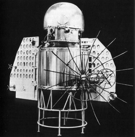
The Venera 1 spacecraft
Their first attempts to even flyby Venus was Venera 1, on February 4, 1961. But it failed to even escape Earth orbit. This was followed by Venera 2, launched on November 12, 1965, but it went off course just after launch.
Venera 3 blasted off on November 16, 1965, and was intended to land on the surface of Venus. The Soviets lost communication with the spacecraft, but it’s believed it did actually crash land on Venus. So I guess that was the first successful “landing” on Venus?
Before I continue, I’d like to talk a little bit about landing on planets. As we’ve discussed in the past, landing on Mars is really really hard. The atmosphere is thick enough that spacecraft will burn up if you aim directly for the surface, but it’s not thick enough to let you use parachutes to gently land on the surface.
Landing on the surface of Venus on the other hand, is super easy. The atmosphere is so thick that you can use parachutes no problem. If you can get on target and deploy a parachute capable of handling the terrible environment, your soft landing is pretty much assured. Surviving down there is another story, but we’ll get to that.
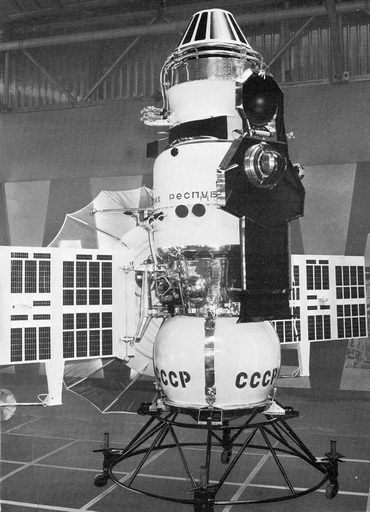
Venera 4 came next, launched on June 12, 1967. The Soviet scientists had few clues about what the surface of Venus was actually like. They didn’t know the atmospheric pressure, guessing it might be a little higher pressure than Earth, or maybe it was hundreds of times our pressure. It was tested with high temperatures, and brutal deceleration. They thought they’d built this thing plenty tough.
The Venera 4 spacecraft. Venera spacecraft 3 to 6 were similar. Image supplied by NASA
Venera 4 arrived at Venus on October 18, 1967, and tried to survive a landing. Temperatures on its heat shield were clocked at 11,000 C, and it experienced 300 Gs of deceleration.
The initial temperature 52 km was a nice 33C, but then as it descended down towards the surface, temperatures increased to 262 C. And then, they lost contact with the probe, killed dead by the horrible temperature.
We can assume it landed, though, and for the first time, scientists caught a glimpse of just how bad it is down there on the surface of Venus.
Venera 5 was launched on January 5, 1969, and was built tougher, learning from the lessons of Venera 4. It also made it into Venus’ atmosphere, returned some interested science about the planet and then died before it reached the surface.
Venera 6 followed, same deal. Built tougher, died in the atmosphere, returned some useful science.
Venera 7 was built with a full understanding of how bad it was down there on Venus. It launched on August 17, 1970, and arrived in December. It’s believed that the parachutes on the spacecraft only partially deployed, allowing it to descend more quickly through the Venusian atmosphere than originally planned. It smacked into the surface going about 16.5 m/s, but amazingly, it survived, and continued to send back a weak signal to Earth for about 23 minutes.
For the first time ever, a spacecraft had made it down to the surface of Venus and communicated its status. I’m sure it was just 23 minutes of robotic screaming, but still, progress. Scientists got their first accurate measurement of the temperatures, and pressure down there.
Bottom line, humans could never survive on the surface of Venus.
Venera 8 blasted off for Venus on March 17, 1972, and the Soviet engineers built it to survive the descent and landing as long as possible. It made it through the atmosphere, landed on the surface, and returned data for about 50 minutes. It didn’t have a camera, but it did have a light sensor, which told scientists being on Venus was kind of like Earth on an overcast day. Enough light to take pictures… next time.
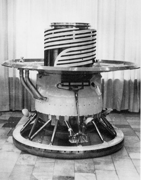
The Venera 9 spacecraft. Image supplied by NASA
For their next missions, the Soviets went back to the drawing board and built entirely new landing craft. Built big, heavy and tough, designed to get to the surface of Venus and survive long enough to send back data and pictures.
Venera 9 was launched on June 8, 1975. It survived the atmospheric descent and landed on the surface of Venus. The lander was built like a liquid cooled reverse insulated pressure vessel, using circulating fluid to keep the electronics cooled as long as possible. In this case, that was 53 minutes. Venera 9 measured clouds of acid, bromine and other toxic chemicals, and sent back grainy black and white television pictures from the surface of Venus.
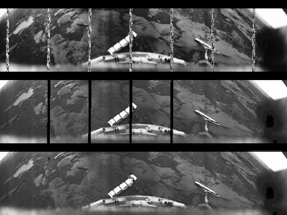
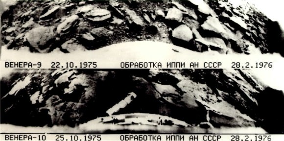
In fact, these were the first pictures ever taken from the surface of another planet.
Images from Venera 9 (top) and Venera 10 (bottom). Public Domain Images, courtesy of NASA/National Space Science Data Center.
Venera 10 lasted for 65 minutes and took pictures of the surface with one camera. The lens cap on a second camera didn’t release. The spacecraft saw lava rocks with layers of other rocks in between. Similar environments that you might see here on Earth.
Venera 11 was launched on September 9, 1975 and lasted for 95 minutes on the surface of Venus. In addition to confirming the horrible environment discovered by the other landers, Venera 11 detected lightning strikes in the vicinity. It was equipped with a color camera, but again, the lens cap failed to deploy for it or the black and white camera. So it failed to send any pictures home.
Venera 12 was launched on September 14, 1978, and made it down to the surface of Venus. It lasted 110 minutes and returned detailed information about the chemical composition of the atmosphere. Unfortunately, both its camera lens caps failed to deploy, so no pictures were returned. And pictures are what we really care about, right?
Venera 13 was built on the same tougher, beefier design, and was blasted off to Venus on October 30, 1981, and this one was a tremendous success. It landed on Venus and survived for 127 minutes. It took pictures of its surroundings using two cameras peering through quartz windows, and saw a landscape of bedrock. It used spring-loaded arms to test out how compressible the soil was.
The surface of Venus as captured by Soviet Venera 13 lander in March of 1982. NASA/courtesy of nasaimages.org
Venera 14 was identical and launched just 5 days after Venera 13. It also landed and survived for 57 minutes. Unfortunately, its experiment to test the compressibility of the soil was a botch because one of its lens caps landed right under its spring-loaded arm. But apart from that, it sent back color pictures of the hellish landscape.
And with that, the Soviet Venus landing program ended. And since then, no additional spacecraft have ever returned to the surface of Venus.
It’s one thing for a lander to make it to the surface of Venus, last a few minutes and then die from the horrible environment. What we really want is some kind of rover, like Curiosity, which would last on the surface of Venus for weeks, months or even years and do more science.
And computers don’t like this kind of heat. Go ahead, put your computer in the oven and set it to 850. Oh, your oven doesn’t go to 850, that’s fine, because it would be insane. Seriously, don’t do that, it would be bad.
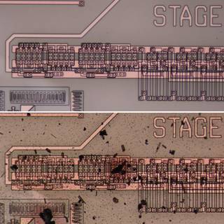
Engineers at NASA’s Glenn Research Center have developed a new kind of electrical circuitry that might be able to handle those kinds of temperatures. Their new circuits were tested in the Glenn Extreme Environments Rig, which can simulate the surface of Venus. It can mimic the temperature, pressure and even the chemistry of Venus’ atmosphere.
A before (top) and after (bottom) image of the electronics after being tested in the Glenn Extreme Environments Rig. Credit: NASA
The circuitry, originally designed for hot jet engines, lasted for 521 hours, functioning perfectly. If all goes well, future Venus rovers could be developed to survive on the surface of Venus without needing the complex and short lived cooling systems.
This discovery might unleash a whole new era of exploration of Venus, to confirm once and for all that it really does suck.
While the Soviets had a tough time with Mars, they really nailed it with Venus. You can see how they built and launched spacecraft after spacecraft, sticking with this challenge until they got the pictures and data they were looking for. I really think this series is one of the triumphs of robotic space exploration, and I look forward to future mission concepts to pick up where the Soviets left off.
Are you excited about the prospects of exploring Venus with rovers? Let me know your thoughts in the comments.